State law in Washington that dates from the 1990s requires that the Washington Department of Transportation complete a “bicycle transportation and pedestrian walkways plan”. The last version of the plan was created in 2008, and is getting a brand new update. A draft of part one of the plan is available to read and comment on at this online open house until February 15 of 2021.
Part one of the plan is in large part devoted to high level concepts around walking, biking, and rolling facilities, overall purpose and need, the current state of Washington’s active transportation infrastructure, and what WSDOT has heard from community member while conducting public outreach for the plan. Part two, which will come out next year, will cover specific policy topics around project implementation, performance measures, and next steps for developing an actual implementation plan- in other words, even deeper into the weeds.
The entire plan is worth your time, but at 184 pages the draft is a bit hard to get through. I want to highlight a particularly rich area of the report, in case you don’t have time to read it. Chapter 4 looks at cost estimates for statewide needs and opportunities. Early in the report, dropped in a section about benefits of active transportation is the fact that “for the approximate cost of one Seattle-area freeway interchange, approximately 300 miles of trail could be constructed”. These numbers come from WSDOT’s own planning level cost estimates, and it’s facts like these that are the best part of the report.
The report looked at the 6,977 miles of state highway and noted that 1,685 of them went through a city, town, or census-designated place. The plan looked at costs to improve state routes in those population centers in part because that is where a large majority of the bicyclist and pedestrian injuries and fatalities occur, 83% between 2010 and 2020.
The vast majority of people walking and biking hurt on our state highways are in population centers.
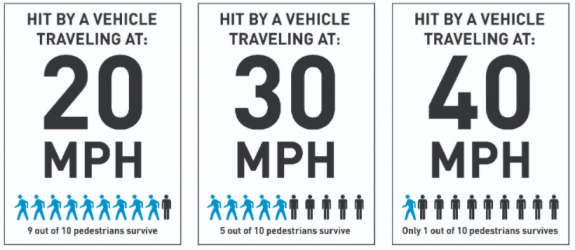
86% of pedestrian and bicyclist fatalities in Washington occurred on roads with posted speeds of 30 mph or higher during the same timeframe. The active transportation plan looks at the mileage of state highways with posted speeds over 30 mph, 849 miles, and calculates a one-time statewide need to implement changes bring vehicle speeds below 30 mph at $283 million.
Also estimated is the amount of money to improve the 542 miles of state highways that do not have adequate pedestrian facilities and 1,142 miles where there are not separated bike facilities (on highways where people walking and biking are not prohibited) at $1.8 billion. Add to that $1.6 billion to improve crossing treatments at 7,564 locations on the state system, and 1.98 billion to improve 680 bridges on state routes where pedestrian & bike facilities are nonexistent or substandard.
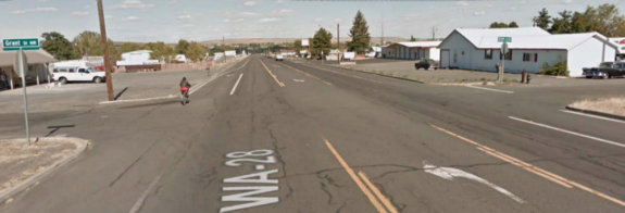
“Intersection gaps” like the one pictured here near Soap Lake were looked in by the Active Transportation plan.
Added together, the total for those improvements for safety and access to the entire statewide highway system totals $5.7 billion. These aren’t upgrades, they are basic elements that a statewide transportation system should have, before the state spends money expanding it.
Costs associated with adding basic infrastructure to the state system
Governor Inslee’s proposed transportation budget for the next two years totals $6.2 billion in spending, $3.7 billion of that for the Highway Improvements program, which mainly goes to expanding highway capacity, while a tiny portion of the biennial budget goes toward these basic safety improvements. Washington State has had a Target Zero goal for twenty years now, and the state’s transportation agency knows what it will take to make the changes needed to get us there.
Pedestrian and bicyclist fatalities in Washington, 2010-2019
We’ll be closely watching for part 2 of the Active Transportation plan to see how we can get there. In the meantime, read part 1 and submit your comments.
In March of 2019, after Mayor Jenny Durkan overrode the finalized plans that the Seattle Department of Transportation had developed for 35th Ave NE in Wedgwood and removed dedicated space for people to bike on that street, it was SDOT who had to go out sell this politically-motivated change. For months, anyone following the issue had seen the opponents of the bike lanes, with well-established ties to the Mayor, push back against the project. SDOT Director Sam Zimbabwe had been officially in his post for only a month before the decision was announced, but the department had to come up with a justification for the change.
One of those reasons cited was the fact that the inclusion of a protected bike lane on 35th Ave NE in the bicycle master plan didn’t adequately take transit into account. Seattle’s bike plan and its transit plan had a conflict on 35th. SDOT’s blog post about the cancelled bike lanes included the fact that “the new design will also allow efficient transit travel through the corridor with southbound buses making in-lane stops at the curb” as opposed to the prior design, which required buses to merge back with traffic after stopping in the bike lane.
Shortly after that, Zimbabwe told Michelle Baruchman of the Seattle Times answering a question about 35th Ave that “we’ve got a lot of modal plans that are getting to be outdated, and how [do] we take those and overlay them to try and work out some of these conflicts at the citywide level, if we can?” The conversation was being turned away from the broken decision-making process onto the city’s long established plans and goals.
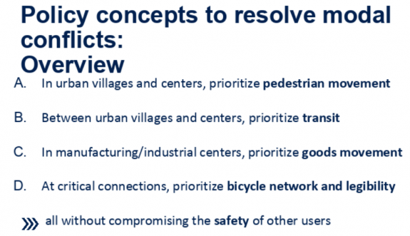
Since then, it looks like this idea that the modal plans don’t “play nice” with each other has taken deeper root at the agency. SDOT has been working on developing an in-house tool that would look at all roadway segments in the city that are “deficient”, meaning they don’t appear to have enough space for the modes in multiple plans, and use a proposed policy framework to resolve those modal conflicts.
So far, we don’t have a good idea yet of where bicycle infrastructure would get prioritized over other modes. According to the policy, “critical connections” would receive priority. Included there is the concept of prioritizing pedestrian movement in all of Seattle’s urban centers and villages, some of the most contested space in the city. “Critical bike segments [would] share priority with pedestrians” in urban villages. There are still a lot of questions about how a critical segment would be defined and how that map would be developed. Right now, it looks like this change will eliminate the bicycle master plan as we know it, and the goals that go along with it, like allowing 100% of the city to live within 1/4 mile of an ALEGRA (all ages, languages, education, genders, races, abilities) bike facility by 2035.
This policy is being developed with SDOT’s Policy and Operations Advisory Group (POAG), which originally convened in response to a council resolution to develop a consistent traffic signal policy, a finalized version of which SDOT released this month. Like this modal prioritization policy, the signal policy was heavily centered around adjacent land use.
SDOT’s proposed framework for resolving modal conflict.
At the November POAG meeting, SDOT presented four different examples of how this prioritization might impact outcomes on different street segments. Looking at those concrete examples highlights the shortcomings of the proposed policy.
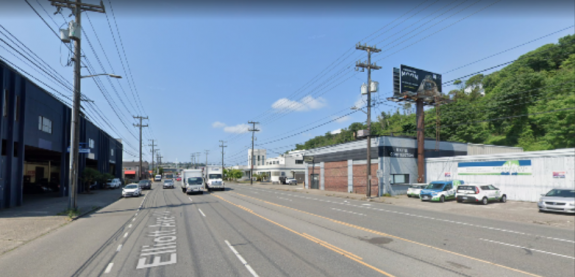
Elliott Ave W/15th Ave W in Interbay
Elliott Ave W in Interbay
Elliott Ave W & 15th Ave W are massive (70 foot+) streets with 7 lanes, including curbside Business Access and Transit (BAT) lanes for most of its length. It is not considered “in network” for bicycle facilities, likely because they were not included in the bicycle master plan, even though the nearest parallel bike facility, the terminal 91 bike path, is separated by railroad tracks with a connecting pedestrian bridge. Since the neighborhood is a manufacturing/industrial center, freight access would be at the top of the proposed priority list here, in addition to the transit lanes already in place as part of the frequent transit network. The outcome presented at the meeting is allowing freight to use the bus lanes, turning them into Freight and Transit (FAT) lanes. Additional pedestrian facilities or the impact of reducing auto capacity on the pedestrian environment were not considered here in the exercise.
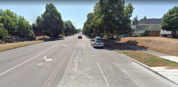
35th Ave SW in West Seattle
35th Ave SW in West Seattle
The segment of 35th Ave SW looked at here is not located in an urban village or center, and not on the freight network, but is on the frequent transit network. The current bike master plan indicates that protected bike lanes should be included on the street, but according to SDOT, “This is an unlikely critical bike segment as there are parallel bike routes that are flatter than 35th Ave SW”. It’s unclear what that proposed route would be. Bus-only lanes would be the proposed policy outcome here. It’s important to note that it’s not clear that those bus lanes would even be prioritized if it meant taking away general purpose lanes here, particularly on the busier northern segment of 35th (at least prior to the West Seattle bridge closure). A proposed rechannelization there was scaled back during the current administration.
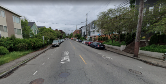
12th Ave E in Capitol Hill
12th Ave E in Capitol Hill
The only example inside an urban center or village, no buses use this street, though one is proposed in Metro’s long range plan. It’s also a minor truck route. According to SDOT, this is an “unlikely critical bike segment”, even though the paint bike lanes south of Denny Way are probably some of the busiest unprotected bike facilities in the city. This is probably because the Bicycle Master Plan shows a protected bike lane on Broadway north of the existing lane which also ends at Denny Way, not on 12th. Again, it’s not clear how “critical” bike lane segment is defined.
Since it’s inside an urban center, the proposed policy would put pedestrians at the top of the list here: the current sidewalks are half as wide as Seattle’s right-of-way manual says they should be. So the outcome would be to “prioritize future sidewalk widening to meet Streets Illustrated standards”, though it’s hard to imagine a time horizon where that would actually occur. In the meantime, the existing on-street parking lanes would be retained and “strategic widenings at intersections, bike parking, other pedestrian realm uses” would be identified.
In other words, a potential sidewalk expansion in the future justifies keeping things mostly the same in the near-term.
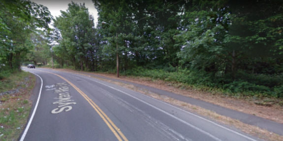
Sylvan Way in West Seattle
Sylvan Way in West Seattle
Sylvan Way is shown as the example where bicycle facilities would be at the top of the list for prioritization. SDOT called the street an “excellent candidate for designation as a ‘critical bike segment’ because it is one of the few pathways between the Delridge Valley and High Point”. But the current roadway, with two twelve foot travel lanes and a five foot uphill bike lane, is too narrow to add protected bike lanes, so the “options include constructing a multi-use trail side path, or widening the street to accommodate the PBL”. Without a specific grant, that would be likely to eat up a large segment of the bike budget, but it’s possible.
With these four examples, the only space even theoretically proposed to be reallocated away from general purpose vehicles was the bus lane on 35th Ave SW. For advocates of a citywide ALEGRA bike network, it’s hard to see what the benefit will be to moving forward with a watered down “critical segment” version of the bicycle master plan, particularly if it looks to be as skeletal as the examples provided so far have shown.
The biggest thing that seems to be missing from the policy is an actual way to account for how much street space is allocated to none of these modes, but to general purpose traffic. Bryce Kolton, a representative on the POAG from the transit advisory board, told me, “We didn’t even see the words or any term that could be used for the words ‘general purpose traffic’ or ‘single occupancy vehicle’ appear on slides until the fourth meeting”, mentioning that references to the majority of traffic didn’t appear until urging from POAG members.
Kolton is not optimistic that this policy will result in more multimodal projects moving forward. “My question for SDOT, which I have not received a satisfactory answer for, is how come, with all of the plans we have…are we continuously having watered down transportation projects. Why? Until they can tell me why established plans have not been completed when they aren’t for car traffic…I don’t think a multi-multimodal plan is the answer, and I don’t have any faith in them to go back and be able to fix it.”
Anna Zivarts, a pedestrian advisory board representative on the POAG, was slightly more optimistic about the overall goal of the policy. “I think it does need to be a conversation that happens across the modal boards,” she told me. “The question then becomes, is it an equal distribution? How do we then distribute [the street space]? And that I think is what needs to be provided by SDOT or provided by our elected leaders: what is the vision for the city?”
Noting that the policy is still a draft, she added, “From what I have seen, it’s mostly a way of preserving the status quo. I think it makes sense to integrate…if the integration is seen as a way to force the political conversation so the changes can then happen more easily, then that’s helpful, but I’m not sure the city’s going to have the political will to do that.”
SDOT will be presenting a final proposed policy at the next POAG meeting at the end of January. Once it’s finalized, the department will start to use it internally, but SDOT also has a goal of including a citywide integrated transportation map in the 2024 Comprehensive Plan update, which would enshrine these proposed changes even more deeply in city policy. This framework would absolutely play a large role in the development of the transportation levy set to replace Move Seattle at the end of 2024 as well. There’s a lot that could come out of a shift like this, and we have to make sure that it’s not actually a step in the wrong direction.
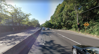
Last night, 5 days after SDOT announced that it had installed two speed-display signs on either side of the Aurora bridge, a pedestrian was hit and killed on the Queen Anne side of Aurora Avenue N by someone driving. The Seattle Times reports that as of last night SPD did not have any information to provide about the events that proceeded the crash. We know the crash happened on the west side of Aurora Ave in the 2400 block and that the victim has been described as a 41-year old man whose identity is not yet known. The driver reportedly left the scene.
This marks the 10th traffic fatality on Seattle’s portion of Aurora Ave N since last January. Nine of those ten fatalities were people walking on Aurora. Many more people have been seriously injured on the street in that timeframe. Aurora Ave and Rainier Ave frequently change places as the top street for traffic fatalities in the city of Seattle.
Aurora Ave just got a #VisionZero upgrade with new speed radar signs. Thanks to @Reuvencarlyle for supporting our work to end traffic deaths and serious injuries on city streets by 2030! https://t.co/uDiM37ubKf
— Seattle Department of Transportation (@seattledot) December 18, 2020
Last year, when the city announced that it was lowering the speed limit on the vast majority of arterial streets to 25 mph, it noted that state routes like Aurora would not be included in that but that also said that “the City will also partner with the Washington State Department of Transportation (WSDOT) to reduce speeds on state highways within city limits, including Aurora Ave N on State Route 99 and Lake City Way on State Route 522”. The speed limit remains 40 mph on Aurora Ave all the way from the SR-99 tunnel to Green Lake, the longest stretch in the city with a speed limit that high.
40 mph+ speeds substantially reduces the likelihood that a pedestrian will survive a crash
WSDOT recently spent $19 million repaving the entirety of Aurora Ave from Roy Street to the city line, and despite both agencies having a shared goal of reducing fatalities and serious injuries to zero by 2030, minimal safety improvements were completed with that repaving. According to state law, SDOT is responsible for the traffic operations on the street, though the state would need to approve a change to the speed limit. Why hasn’t it happened yet?
We recently reported that the state 2021-2023 transportation budget will likely include money to complete a $2 million planning study for Aurora, which would not include any money for actual roadway changes. The state has already completed many studies encompassing portions of this dangerous route, what is needed now is action.
Governor Jay Inslee has released his proposed two-year budget for July 2021 through June 2023 in advance of the legislative session starting in January. He has touted the budget as the “strongest environmental justice proposal in U.S. history”, and says that if approved it would put Washington on a path to reduce statewide emissions by 35% by 2030.
The centerpiece of the climate actions include a cleaner fuel standard, aligning us with Oregon and California’s standards, and a cap-and-invest program aimed at the state’s largest carbon polluters.
On the transportation side, the $6.2 billion transportation budget includes a proposed $724 for the state’s continued work to remove culverts blocking access to salmon habitat, and $190 million ($318M over four years) to continue converting the Washington state ferry fleet to hybrid electric. It also includes $15 million to electrify local transit systems, and $1.5 million for electric vehicle promotion and outreach.
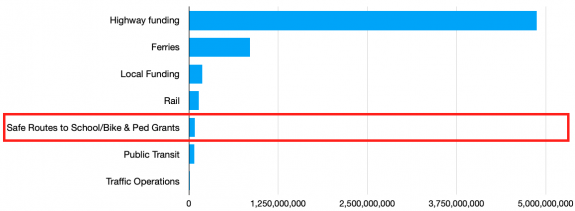
It also includes a $20 million boost to the state’s grant program for Safe Routes to School programs as well as the Pedestrian and Bicyclist grant program. That will bring the total funding for both programs to just under $80 million, or 1.3% of the statewide transportation budget.
The local active transportation grant programs relative to the rest of WSDOT’s budget.
The highway management & facilities, highway improvements, and highway preservation programs make up 78% of the state’s transportation budget, or sixty-one times the amount allocated to those safety grants.
WSDOT has already submitted its list of projects it expected to be funded under both the Safe Routes to School and the Pedestrian and Bicyclist program for 2021-2023. Local agencies submitted over $189 million dollars’ worth of projects. Only 16 out of 107 projects were expected to be funded in the Pedestrian and Bicyclist program and 23 out of 125 in the Safe Routes to School program, leaving dozens of worthy projects with real safety impacts unfunded. With the funding boost from the governor’s budget, more will move forward.
Locally, the 1st Ave NW neighborhood greenway in Greenwood is set to receive $1 million in Safe Routes to School funding. $1.8 million for the protected bike lane on MLK Jr Way S connecting Judkins Park Station, $2 million for sidewalks on Renton Ave S just south of Seattle’s city limits, and $1.5 million for a planning study on Aurora Ave N were the projects initially set to receive Pedestrian and Bicyclist Program funding.
With the additional boost in the governor’s budget, it looks like a neighborhood greenway along 135th Ave NE connecting the Olympic Hills greenway to the Cedar Park Elementary greenway is likely to receive the $620,000 that SDOT was hoping to be awarded.
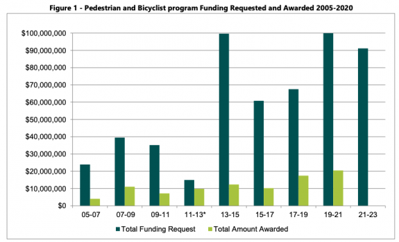
That leaves dozens of projects that could make walking and biking to school easier and improve the ability to get around without a car in cities all across Washington. WSDOT includes a chart in their program update showing the historical availability of funding compared with the requests from local agencies. These are exactly the types of projects that should all receive full funding from the state department of transportation.
Pedestrian & Bicyclist program funding relative to funding requests, since 2005.
Meanwhile, the WSDOT “highway improvement” program is set to receive funding for expansion of I-5 at Joint Base Lewis-McChord of $101 million, more than the entire requests for funding in either grant program. There’s also $112 million to widen I-90 at Snoqualmie Pass, $533 million for the next phase of the Puget Sound Gateway highway expansion project, and $205 million for the next phase of the North Spokane Corridor highway expansion. Those projects have all been approved by the legislature in previous sessions- and that’s just the big ticket items. It’s likely the legislature will seek to add to that list in the upcoming session.
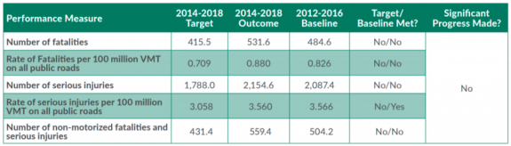
In October, the Washington Traffic Safety Commission received a presentation on WSDOT’s Safety Implementation Plan. The agency’s Target Zero goal is the same as Seattle’s- zero serious injuries or fatalities on Washington’s roadways by 2030- and the update for the safety commission was pretty blunt. “WSDOT failed to meet targets and did not make significant progress” said one slide, which included a chart showing how much Washington is off-track.
WSDOT’s Target Zero goals as presented to the WA Traffic Safety Commission.
One reason Washington is not making progress on traffic safety is likely the fact that it continues to underfund these valuable safety programs that also happen to further the climate goals that Governor Inslee’s budget is centered around. The funding boost here is welcome, but it’s clearly not enough.
Last week, District 4 Councilmember Alex Pedersen’s office sent an email including highlights from his first year in office. It included a section titled “Transportation and Climate Change”. An excerpt:
Seattle is not about to let up on its efforts to reduce address climate change, which currently include reducing carbon emissions and increasing our resiliency (“adaptation”) in the face of the negative environmental changes already underway. But as Chair of the Council’s Transportation & Utilities Committee, I can tell you it’s a relief that a new federal administration is entering that clearly embraces the science, the national and international efforts required to reverse the global threat, and the environmental and economic benefits of transitioning to a more green economy. This includes President-Elect Biden’s appointment to the U.S. Dept of Transportation, the Dept of Energy, and a new cabinet-level climate advisor. I believe the climate calvary [sic] is coming.
While reaction to the news of former South Bend Mayor Pete Buttigieg being named Biden’s Secretary of Transportation has been mixed among transportation advocates, there is little doubt that Biden is taking the issue of climate change more seriously than probably any other incoming President in history. There is an unprecedented amount of momentum behind the incoming administration to do climate-related work.
But with the recent news that Seattle’s overall emissions increased between 2016 and 2018, and the fact that we are wildly off-course on reducing our transportation emissions compared to the goal passed by the city council in 2013, it’s dangerous for the chair of the transportation committee to be waiting for the federal government to get Seattle on track to reduce emissions. The climate cavalry is here, and it is us.
Most cities in the US do not have a publicly-owned power utility, much less one that has been carbon-neutral for fifteen years. Few cities have bucked a national trend of declining transit ridership due to decades of disinvestment. Even if you include industrial and air sector emissions, Seattle’s per capita emissions are already less than half of the nationwide per capita total. We have a huge advantage relative to the rest of the country, and we want the cavalry to come help us?
For the chair of the Transportation & Utilities Committee, it has been a very unusual year to conduct committee business, that’s for sure. But after the outgoing transportation chair, Mike O’Brien, made sure that the committee had a role in shepherding the progress of the modal master plans, this year the committee has spent no time reviewing the updates & impact to project completion from the mayor’s budget cuts. SDOT is far behind on its yearly goal for new sidewalk completion, as just one example, with the schedule to catch back up currently unclear. The 2013 Climate Action Plan, which the Durkan administration has only tacitly embraced, connects all of these existing plans together and recognizes that they further the city’s climate goals, but implementation requires leadership.
Earlier this year, Councilmember Pedersen chaired the committee to send the renewal of the Seattle Transportation Benefit District back to the voters. The Mayor’s proposal was smaller than the original STBD passed in 2014, due to the exclusion of a car-tab fee while the fate of I-976 was uncertain, which translates to fewer transit service hours being funded. A 50% increase was proposed in committee, from a 0.1% to a 0.15% sales tax, but Pedersen voted no on that amendment. Thankfully it passed anyway, and voters resoundingly said yes. Just last month, with a car-tab fee unlocked after I-976 was ruled unconstitutional, Pedersen teamed up with councilmembers Lewis and Herbold to propose using the money to fund bridge maintenance instead of transit, weeks after SDOT just cut the ribbon on a brand new $100 million bridge in SoDo.
Seattle scaling back transit investments, on the heels of the wildly successful transit benefit district providing very frequent transit service to 70% of city households in 2019, will absolutely lead to more car trips and increased emissions. The Biden administration can’t save us from making own-goals like that.
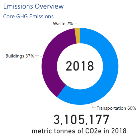
Transportation emissions are 60% of the city’s core emissions but Seattle still lacks a concrete roadmap to achieve reductions. The Transportation & Utilities committee did make sure to find time to pass Seattle City Light’s transportation electrification plan, which certainly needs to be a part of the solution, but electric vehicles cannot be the entire solution, and Seattle is in a relatively advantageous position to show the rest of the country how it is done. Seattle’s reputation as being on the cutting-edge of urban design & innovation is wearing thin as our leaders choose the easy way forward.
Transportation: 60% of core emissions
The Biden administration is not going to prevent Seattle from building a new cruise ship terminal. Nor is it likely to stop the building of another regional airport even as emissions at Sea-Tac and King County airports have shot up 40% since 2008.
Thinking of the incoming administration as the climate cavalry is backwards, and Seattle deserves better.
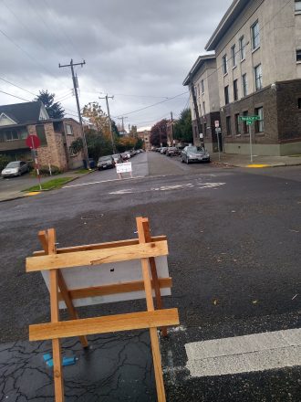
Street closure signs in place along 14th Ave in November.
Seattle’s network of Stay Healthy Streets, in place for most of this year on a portion of the city’s neighborhood greenway network, noticeably left out most of Seattle’s urban centers where a large proportion of the rental housing exists. Neighborhoods like the U District, Eastlake, First Hill, Northgate, South Lake Union, Uptown, and Capitol Hill either don’t have neighborhood greenways running through them or weren’t selected to be part of the Stay Healthy Street network.
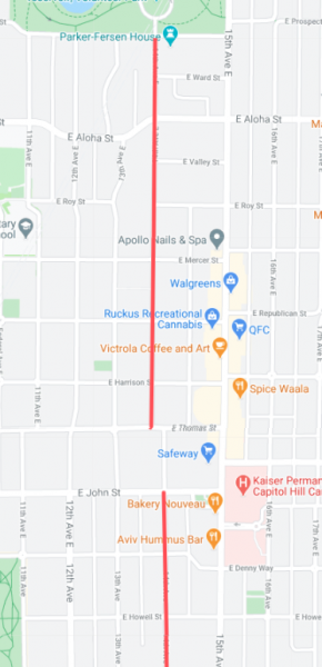
The Stay Healthy Block program, similarly named but separate, was created by SDOT to allow “residents, community-based organizations, and non-profits” to close a neighborhood street to create more outdoor space. At the beginning of November, SDOT issued a permit to Capitol Hill resident Christopher Hoffman allowing “street closure” signs to be placed on a long stretch of 14th Avenue south of Volunteer Park. The area extended from Prospect Street to Olive Street, with a one-block gap in the middle to accommodate the Safeway parking lot.
Capitol Hill, pressed for open space in its densest segments, clearly had a pent-up demand for a space like this, and the street was an instant hit. All summer long, some residents had been daring enough to use the street to jog or stroll for a bit, but with the signs up the volume of pedestrians using the street skyrocketed even as temperatures outside went down.
The stretch of 14th Ave that was opened to walking, biking and rolling in November.
Unfortunately, the street signs also were instantly hit by cars, since their frames, provided by Seattle Neighborhood Greenways and not the city, were made of wood. The signs were replaced multiple times, but not always right away, with broken signs often staying in the street for days. Some were clearly intentionally destroyed, with one “street closed” sign ripped to shreds.
This past Monday morning, under threat of fine, Hoffman removed all remaining signage from 14th Ave despite the recent announcement from the city that the Stay Healthy Block program would be extended until the end of February. SDOT has not officially extended the permit past the end of November, and it’s not clear that a new permit will ever be issued.
The primary issue with permit renewal is an odd provision of the Stay Healthy Block permit: SDOT’s rules only allow a street to be closed for twenty hours a week, though the times can vary but they can’t go past 9pm on any day. In other words, for the other 148 hours in a week, Seattle’s narrow sidewalks have to suffice if you like to use a Stay Healthy Block for exercise or transportation.
Meet up in the center of the park at 7ish. Leave at 730. Every Thursday from now until forever rain or shine. Bikes, beers, illegal firepits, nachos, bottlerockets, timetraveling, lollygagging, mechanicals, good times.ShareMastodonTwitterFacebookRedditEmail
Details from Seattle Parks: On scheduled weekends from May to September, a portion of Lake Washington Boulevard will be closed to motorized vehicles from 10 a.m. Saturday to 6 p.m. Sunday. “Seattle Parks and Recreation[…]
Join me for a 7 mile bike ride going from Capitol Hill into the University District at a Leisurely pace. We’ll visit various sites relevant to Seattle’s current gayborhood and gathering sites around UW.ShareMastodonTwitterFacebookRedditEmail
Details from Seattle Parks: On scheduled weekends from May to September, a portion of Lake Washington Boulevard will be closed to motorized vehicles from 10 a.m. Saturday to 6 p.m. Sunday. “Seattle Parks and Recreation[…]
Meet up in the center of the park at 7ish. Leave at 730. Every Thursday from now until forever rain or shine. Bikes, beers, illegal firepits, nachos, bottlerockets, timetraveling, lollygagging, mechanicals, good times.ShareMastodonTwitterFacebookRedditEmail