— Advertisement —
  • Changes at Rainier and MLK coming in 2022, but what’s next for Accessible Mount Baker?

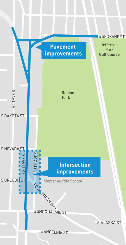
    As the Seattle Department of Transportation moves ahead with designing a planned protected bike lane between Mount Baker light rail station and the planned Judkins Park light rail station on MLK Jr Way S, with the bike lane planned to be completed close to the station’s grand opening in 2023, we now know that pedestrian improvements at one of Seattle’s most dangerous intersections along that route are planned to go in next year.

    Those improvements around Rainier Ave and MLK Way are the result of a small allocation of Move Seattle Levy dollars earmarked for Accessible Mount Baker. $6 million was reserved for “near-term improvements”, which in this case are coming during the sixth year of the levy. Two people were killed at this intersection in 2020, and one person was killed in 2019, pointing to a level of urgency at this spot.

    Rainier and MLK Intersection with missing crosswalks on two legs

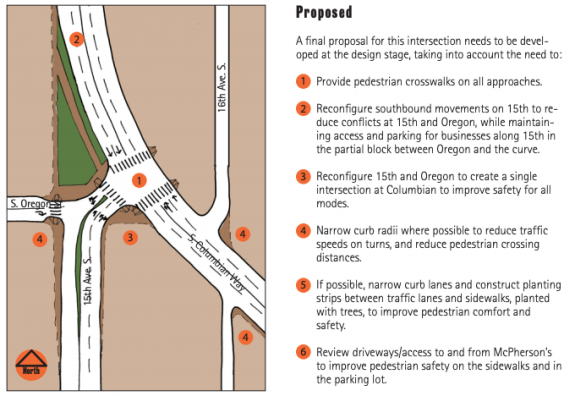
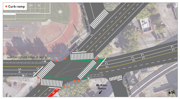
    The biggest improvement planned is the installation of marked crosswalks along the two legs of the MLK/Rainier intersection where they are currently missing. The not-fully-accessible bike and pedestrian overpass will still be there, but crossing at-grade in any direction will become an option. Crosswalks will be wider, sidewalks extended in some areas and repaired in others. A no-right-on-red restriction will be added for vehicles turning from Rainier onto MLK northbound, which will protect people biking if it’s not counteracted by the street’s design.

    Four crosswalks, new curb ramps, and green crossbike markings
    Early diagram showing upgrades at MLK and Rainier, with four crosswalks and bike crossings.

    Text reading Widen the Sidewalks and repair the sidewalk in sections with enlarged sidewalk on Rainier at MLK

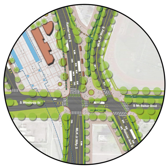
    This intersection is going to be the south end of the protected bike lane on MLK when it’s complete in 2023 and the increased pedestrian space here will help people biking transition to where they want to go next. In the future, the bike lanes may continue south on MLK. Funding to study a possible extension to S Henderson Street was included in this year’s budget.

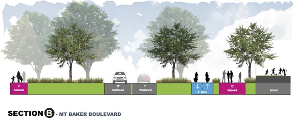
    One possible near-term improvement that SDOT eliminated from contention was the conversion of the northern traffic lanes on Mount Baker boulevard to walk and bike space. With a wide boulevard median already in place this would have been a very cost-effective way to create more space for biking. This improvement was one aspect of the larger vision for Accessible Mount Baker, so maybe it can come back at some point.

    Bike lanes and a walking lane in one lane of the historic Mount Baker Boulevard
    Turning part of Mount Baker Boulevard into a walk bike lane was eliminated from the project last year.

    So what’s next for the Accessible Mount Baker vision? The fate of the Mount Baker Transit Center will in large part determine the answer to that question, but even a concept study on its relocation is paused due to reduced revenue. SDOT”s Ethan Bergerson told me last week that it “still a priority to start again when we have more funding”.

    SDOT is applying for a grant from the Puget Sound Regional Council to use toward the MLK Protected Bike Lane project. If that grant were to come through, that could free up more money for improvements here. But nickel and diming improvements here won’t achieve the larger vision for Accessible Mount Baker, which is really a placemaking project with a lot of beneficial transportation improvements included: making the car-oriented area around Mount Baker Station more pleasant for everyone. The $24 million price tag attached to the entire project in 2015 is surely much higher now but it looks like most of the vision will have to wait for the next transportation levy.


    The bow-tie concept that mostly separates Rainier and MLK with public space created out of street space
    The Accessible Mount Baker concept: still game changing and just out of reach.

    Seattle is embarking on an ambitious plan to build a lot of much-needed social housing around Mount Baker Station. Sound Transit land in the area can be combined with the UW Laundry site, now under City ownership, presenting a truly unique opportunity to create transit-oriented public housing in Seattle. These projects were not fully in view when Accessible Mount Baker was being developed, but they make the vision even more important to realize.

    Map of station area with all land between the station and 25th Ave S as under consideration for housing
    City owned properties that could see public housing under the plan moving forward.

    The Office of Housing has a survey up through this Wednesday (March 3) on what your goals and priorities are for the sites eyed for redevelopment. If we get this right, it could be huge.

    — Advertisement —
  • Lower speed limits on state highways through city proposed by Seattle

    Update (3/1): SDOT has confirmed speed limit changes on Aurora and other corridors is expected in 2021 pending approval from WSDOT. The post has been updated below with comment from the department.

    Late last year, the Seattle Department of Transportation proposed a plan to reduce speeds on most of the highways within the city of Seattle that fall under the jurisdiction of the state of Washington. The proposal, obtained by Seattle Bike Blog via a records request, if fully implemented, would ultimately leave very few remaining stretches of highway through the city with a speed limit above 30 mile per hour.

    This move follows an announcement in fall of 2019 that the City of Seattle would be moving to adjust speed limits on most arterial streets to 25 mph. As of January, the department said that nearly 75% of arterials are currently posted as 25 mph. But WSDOT corridors like Aurora Ave and former WSDOT corridors like Rainier Ave see a huge share of Seattle’s serious traffic injuries and fatalities. SDOT’s proposal to WSDOT notes there were 53 serious injuries or fatalities on Aurora Avenue resulting from collisions between 2015 and 2019 and 595 injuries that weren’t determined to be severe in the same timeframe. Aurora Ave remains a public health crisis.

    The first phase of speed limit reductions would implement a 30 mph speed limit on Aurora Ave N north of Green Lake. Currently that stretch has segments where the limit is 40 mph and segments where it’s 35. The speed limit along 145th St would be lowered to match this speed, as well as the northern segment of Lake City Way. Between 115th and 130th on Lake City Way, in the heart of Lake City, the limit would drop to 25mph matching Seattle’s other arterials. Sand Point Way south of NE 65th St would drop from 35 to 30 mph; north of there SDOT has already implemented a 25 mph limit.

    Map of proposed changes as described in the article
    SDOT’s proposal for the first phase of lowering speed limits on WSDOT corridors on the north end of Seattle. (Click to enlarge)

    South of downtown, East Marginal Way between Spokane Street and the 1st Ave S bridge would go from 35 to 30 mph and a very short segment of Highland Park Way/SR-99 over 1st Ave S would drop from 35 mph to 25 mph.

    Map of proposed changes as described in the article
    SDOT’s proposal for the first phase of lowering speed limits on WSDOT corridors on the south end of Seattle. (Click to enlarge)

    The second phase would lower speeds on the remaining stretch of Aurora south of Green Lake from 40 mph to 35 mph. This is the stretch of Aurora that SDOT’s data shows the most people currently drive at speeds significantly above the limit. The remainder of Lake City Way south of 115th would drop from 35 to 30 mph, and Montlake Boulevard around the ship canal would drop from 30 to 25 mph.

    Map of proposed changes as described in the article
    SDOT’s proposal for the second phase of lowering speed limits on WSDOT corridors on the north end of Seattle. (Click to enlarge)

    The remaining change south of downtown in phase 2 would be a reduction on East Marginal Way south of the 1st Ave S bridge in Georgetown from 45 to 35 mph. This is the segment where SDOT is currently planning to add a grade-separated segment of the Georgetown to South Park trail. A stretch of 1st Ave S over SR-509 in South Park without any sidewalks would drop to 30 mph.

    Map of proposed changes as described in the article
    SDOT’s proposal for the second phase of lowering speed limits on WSDOT corridors on the south end of Seattle. (Click to enlarge)

    The chart below lays out the different limits proposed for each phase alongside the existing speed limit:

    Full chart of speed limit changes as described
    SDOT’s full proposal for lowering speed limits on WSDOT corridors, in two phases. (Click to enlarge)

    Speed limit changes alone aren’t enough to achieve all of our desired safety outcomes, but SDOT notes that “We’re seeing that speed limit signs alone can improve public safety, even without changes in enforcement or urban design. This finding is important because enforcement disproportionately impacts Black people and other people of color”. Increased police enforcement of speed limits doesn’t appear to be on the table here, rightfully.

    The proposal includes data collected on vehicle speeds on these WSDOT corridors, including the difference between posted speed and the median speed (50th percentile), the speed at which half the drivers are driving below. Below are the WSDOT corridors with the biggest difference; most of the segments at the top of the list are proposed to see lower posted speeds in phase 2 as SDOT collects more “before/after” data. This list shows segments where the street design may be playing a larger role in current vehicle speeds than posted speed limit signs.

    Two segments of Aurora at the top of the chart, followed by Lake City Way and SR-509 and then Aurora again.
    Difference between median speed and posted speed limit, in miles per hour, WSDOT corridors in Seattle.

    The proposal does list a few engineering strategies that SDOT is moving ahead with to pair with reduced speed limits, including traffic signal timing changes to reflect the new speed limits, as well as incorporating the new speed limits into any new project designs: design speeds can influence how lane lines are painted. But the primary one listed was increased signage: SDOT’s policy would add signs at every arterial crossing as well as every 1/4 mile: if a driver is going 25 mph they would encounter a speed limit sign every 36 seconds.

    Illustration showing one arterial bisected three times with a multitude of signs every 1,000 feet or so.
    Illustration of SDOT’s updated speed limit sign placement policy.

    SDOT did not provide answers to questions from Seattle Bike Blog about any known current implementation schedule for this proposal or details about how the proposal was received at the Washington State Department of Transportation; we hope to update the post with more information as we get it. Update: SDOT’s Ethan Bergerson tells us that “we are planning for an initial reduction in speed limits on Aurora and other state routes in 2021. We must wait for the official approval from WSDOT, which is expected in the coming months. We will continue our partnership working towards lower speed limits into the future”.

    Bergerson also told us, “Setting corridor speed limits is an important part of our larger Vision Zero strategy. Posting lower speed limits and more frequent signage follows NACTO best practices and has led to lower speeds and fewer crashes in other Seattle neighborhoods. These speed limit reductions open the door for further design changes described above and will be accompanied by signal timing changes and speed limits reductions occurring throughout Seattle.  We expect this comprehensive approach to safety will influence driver behavior and lead to safer speeds.”

    Initial data on Seattle’s first set of speed limit reductions, recorded before the pandemic caused traffic volumes to plummet, showed an overall reduction in crashes of 22%. These case studies were all on arterials in North Seattle, and none of them were high-crash corridors, but so far the data is promising. Implementing lower speed limits on the WSDOT-controlled corridors through the city will be key, though, and now we know just how far along the city is in proposing those changes.

    — Advertisement —
  • Your Voice, Your Choice program to spend 2021 catching up

    For a second year in a row, the Your Voice, Your Choice participatory budgeting program that awards funds for small street and park improvement projects will not be conducting any process to fund new projects in 2021. Last week the Department of Neighborhoods, which administers the program, announced that instead the Your Voice Your Choice team will be focusing on “ensuring that we keep our promise to the community by channeling all remaining funds to Seattle Department of Transportation and Seattle Parks and Recreation to implement previously awarded projects, particularly those in our most vulnerable communities (Equity & Environment Initiative Focus Areas)”.

    The Your Voice Your Choice program is one of the only avenues that exist to allow community suggestions on improvements to make streets safer or parks more accessible, in the case of streets, outside the normal SDOT prioritization process.

    According to Shaquan Smith, Participatory Budget Advisor at the Department of Neighborhoods, the backlog primarily consists of 22 projects that were originally selected by community in 2019. We do know of some 2018 projects that are left to be completed, though. For example, a new crosswalk being added at 14th Ave E and E Aloha Street near Volunteer Park required coordination with Seattle City Light in 2020 and is still not in place.

    Asphalt trail connecting Rainier Ave to the existing trail
    This recently installed trail connection at Rainier Ave and the Mountains to Sound trail was a 2018 Your Voice Your Choice project

    Per Smith, “​Due to COVID, the original $2 million that was meant to go towards the 22 awarded projects in 2019 was cut in half”, hence the city is having to use the 2021 Your Voice Your Choice budget to complete the existing backlog. Smith also cited unforeseen design and construction issues, coordination with other projects, departments, and/or agencies, and delays related to crew bandwidth which increases the costs of labor and materials as contributing to delay.

    We are seeing projects get completed around the city, like the curb extensions recently installed in Queen Anne at the crosswalk at Taylor Ave N and Galer Street, tweeted by Lee Pyne-Mercier:

    You can check the Your Voice Your Choice implementation page to see which projects in your neighborhood are in the backlog.

    “​If there are no other delays, the goal is to complete most of the backlogged projects by the end of 2021 with very few being carried over to 2022. This will allow the program to be able to restart an official new cycle of new projects that year,” Smith said.

    In 2018, the program was criticized for not including a broad enough array of voices in the project selection and voting stages. In 2019, more than 6,500 people voted on projects, or less than 1% of the city’s population, after attempts to broaden participation were made, including adding more paper ballots at Seattle Public Library branches. In 2019, they also allocated an extra amount of money to be available in the City’s “Equity and Environment Initiative Focus Areas”, where they would benefit underserved populations.

    The Department of Neighborhoods now says they will be spending 2021 “restructuring the YVYC program to better meet the immediate needs of Black, Indigenous and people of color (BIPOC) communities who have been most impacted by COVID-19″.

    2021 is also the year that SDOT will be completing the Neighborhood Street Fund projects, which are fewer in number and larger in scope, and which you can read about here.

    — Advertisement —
  • After years of delay, improvements coming to 15th Ave S & S Columbian Way intersection

    Later this year, the Seattle Department of Transportation is set to complete improvements that will make it easier to bike through one of Beacon Hill’s trickiest intersections. The changes planned at 15th Ave S and S Columbian Way come three years after the department was originally scheduled to implement a much bolder reconfiguration of the intersection here, but that iteration of the project was cancelled after local opposition.

    SDOT is repaving a stretch of 15th Ave S, from Spokane to Angeline Streets. Most of the street here is two lanes in both directions without much street parking, and isn’t getting any additional space for bikes. This is unfortunate, as there’s plenty of room and no parking to fight over. Traffic volumes from SDOT’s last citywide volume report show similar vehicle volumes on 15th Ave S as on the segment of Rainier Ave S which has been converted to one lane in each direction with a center turn lane. It also has very similar volumes to S Spokane Street, also getting repaved here, which already has one lane in each direction with painted bike lanes.

    Map of 15th Ave S from Spokane to Angeline Street as highlighted
    Map of planned repaving and intersection improvements on 15th Ave S.

    SDOT is currently planning an all-ages bike route across Beacon Hill for 2023, and currently plans to route people biking onto Beacon Ave in this area. But on the north end of the hill, advocates are pushing for the protected bike lane to be routed onto 15th Ave. At the south end of Beacon Hill, SDOT already installed bike facilities on Swift Ave, which is what 15th Ave turns into. 15th Ave will continue to make sense as a bike corridor and an opportunity was missed here.

    One very wide curved street meeting another one going north south with vast space where they connect
    Arial view of the current configuration of 15th and Columbian Way.

    As for the improvements at 15th Ave and Columbian Way, the plan that would have been implemented in 2018 directed all southbound traffic onto the curve of Columbian Way, with drivers wanting to continue on 15th having to make a right turn. This would have dramatically reduced the size of the massive intersection. A second crosswalk across the intersection from the middle school was to be added. A public plaza would have been created out of the excess street space, with space for people biking to get through the intersection via the crosswalks.

    Original design for the intersection described in the article.
    The original design funded and scheduled to be installed in 2018.

    The design now planned maintains one through lane on southbound 15th Ave S, doesn’t add any additional pedestrian crossings, and doesn’t include any space for people biking northbound from Columbian Way. But it does add a protected bike lane on southbound 15th Ave S by moving the parking in this stretch next to the travel lane. That protected bike lane starts very slightly out of frame at the top of the following image.

    Improvements planned this year as described in the article
    The planned 2021 improvements to 15th and Columbian. (Click to enlarge)

    On the south side of Oregon on 15th Ave, people biking will share space at bus stops with people entering and exiting buses, matching similar designs seen recently on NE 65th Street and 12th Ave S. Southbound, the bike lane disappears very shortly after the bus stop, making its utility questionable. Northbound, the bike lane extends nearly two blocks down to S Angeline Street, the street where the Chief Sealth trail terminates. But at Oregon street, people riding northbound are dumped onto the sidewalk.

    Two bus stops south of Oregon with loading space for buses and bike lanes existing in the same space
    Bike space mixes with bus loading zones south of Oregon Street at 15th and Columbian.

    Though the original redesign here was approved in 2016, improvements at this intersection date to at least 2008, when a reconfiguration very similar to the one proposed was suggested in an SDOT commissioned study, the Southeast Transportation Study.

    Sketch of street redesign similar to the 2018 planned improvements described above
    Proposed redesign for 15th and Columbian from 2008.

    With the project going in now, after years of delay, with most of the changes proposed along the way discarded, is a testament to just how much of an uphill battle it is to redistribute essentially any current street space allocated to vehicles.

    During the last full Seattle Public Schools school year (2018-2019), the southbound school zone speeding camera on 15th Ave S was the most active single camera in SDOT’s school camera arsenal. Over 800 tickets were issued on average per month during the course of the year, 8,012 in total, underlining just how much this intersection redesign is ultimately a school safety project. It’s also likely there would be zero changes happening here if not for the advocacy of groups like Beacon Hill Safe Streets, despite existing plans here on the books. The changes here are clearly hard-won, and should have an impact.

    This weekend and next weekend, SDOT will be closing Columbian Way immediately south of 15th Ave S. Traffic will be detoured via Snoqualmie Street and 15th Ave S. You can read more about the planned improvements here.

    — Advertisement —
  • Georgetown residents push to get a downtown bike connection back into plans

    A group of community leaders and residents of the Georgetown neighborhood have sent a letter this week to SDOT Director Sam Zimbabwe asking the department to “re-engage” on the issue of creating a dedicated bicycle connection between the neighborhood and the rest of the city via downtown Seattle. The letter cites systemic issues facing Georgetown that are not specifically related to the closure of the West Seattle bridge in March of last year, which has led to an increase of traffic diversion through the neighborhood and an increased focus on the transportation needs of the Duwamish valley. From the letter:

    Access to services outside our neighborhood remains a challenge. We do not have direct access to Rapid Ride, and our regular bus service is limited in destinations and times for essential services. Georgetown is not within a walk-shed of a light rail stop and we do not have shuttle service to the nearest station. Bike connectivity is dangerous for anyone who is not a seasoned rider outfitted with the experience and equipment to share routes with cars and freight in substandard conditions, which does not accommodate all abilities. While the bike link between Georgetown and South Park has been a very important and necessary project for which the community has advocated for years, we would like to re-engage on the crucial bike connectivity for Georgetown with the rest of the city, as funding for transit remains a challenge.

    A feasibility study on a Georgetown to Downtown all-ages bike route was one of the projects that SDOT “paused” in 2020 due to budget impacts caused by the COVID-19 crisis. Funding allocated to plan for an extension to the existing multiuse trail in SoDo was also paused at the same time. Last fall, the city council restored funding for planning for the Georgetown to Downtown connection as part of the 2021 budget.

    The planned trail between Georgetown and South Park is moving forward more quickly, with the city council also allocating construction funding for this project in the 2021 budget. SDOT is continuing design work on the trail so we should have more details on this in the coming months. Completing this trail will connect Georgetown to West Seattle and downtown via the Duwamish trail via South Park- if the final gap on Marginal is completed- but this route adds much more time than a direct connection via SoDo would.

    Connection on Albro, Ellis, East Marginal, and 14th Ave S.
    Proposed Georgetown to South Park trail route

    Jon Persak, one of the signatories on the letter and a member of the West Seattle Bridge Community Taskforce, spoke on the subject of SDOT’s design to finally connect the Duwamish trail on West Marginal at a taskforce meeting last week, saying that he feels the conflict over road space on Marginal Way will “suck the air out of the room for other neighborhoods who are trying to get their needs met in terms of bike connectivity to the rest of Seattle”. Peaches Thomas of Duwamish Valley Safe Streets, another signatory, has joined West Seattle Bike Connections in supporting the trail connection.

    The primary connections between Georgetown and Downtown as envisioned on the Bicycle Master Plan are Airport Way and East Marginal Way S.

    Major connections: East Marginal, Airport Way, Ellis
    Georgetown’s connections and envisioned in the Bicycle Master Plan.

    Completing the Georgetown to South Park trail as currently planned will create a safe place to bike along East Marginal Way, but extending this connection further north as envisioned in the Bicycle Master Plan will be a heavier lift. SDOT is moving forward with improvements that will significantly improve East Marginal north of the West Seattle bridge but further south proposed improvements are minimal. “Removing a motor vehicle lane was not recommended”, per SDOT’s website, and making the basic sidewalk improvements that are recommended is not even funded at this point.

    Unfunded plans on the south end of East Marginal Way show minimal improvements.

    A protected bike lane on Airport Way has appeared on ambitious bike lane plans before, most recently in 2015, but the last time it was proposed, the project did not ultimately move forward due to a concern over the need for large numbers of vehicles needing to use Airport Way as an I-5 alternative in an emergency, so this too seems like a heavy lift.

    The only other streets that fully connect Georgetown to SoDo are 1st Ave S and and 4th Ave S. Both of the existing bridges over the train tracks between those neighborhoods are coming under increased scrutiny due to seismic vulnerabilities that will cost a lot (!) of money to fix. Northbound traffic on the 4th Ave S bridge has already been reduced to one lane to reduce further deterioration.

    As the letter notes, “…Georgetown is historically often passed over for critical needs”. Most of the construction funding for bike facilities through the end of the Move Seattle levy in 2024 is accounted for, but if planning work was prioritized for a Georgetown to Downtown bike lane, completing this very needed connection could become a reality. It is absolutely a connection that needs to happen as soon as possible.

    — Advertisement —
  • King County expected to examine helmet law as Cascade Bicycle Club supports repeal UPDATED

    Correction: the data compiled by Ethan Campbell of Central Seattle Greenways has been updated after further analysis of the citations issued revealed a number of duplicates. The overall summary of the information has not significantly changed.

    The King County Board of Health is likely to add a review of the county’s bicycle helmet requirement to its 2021 workplan today at its monthly meeting. This move comes after the Cascade Bicycle Club, nation’s largest statewide bicycle nonprofit, formally announced earlier this month that they are in support of repealing the law requiring bike riders in the state’s largest county to wear helmets.

    Cascade’s Tamar Shuhendler told me that the bicycle club sees a responsibility to reexamine its decision on the helmet law, as one of the organizations that originally had supported a King County helmet law. When I asked her about the reaction in the cycling community to the club coming out for repeal, she acknowledged the diversity of opinion on the issue, saying Cascade “welcomes as much community input as we can possibly get”, in advance of any final action on the law.

    King County Councilmember Jeanne Kohl-Welles announced she would introduce the amendment to the workplan earlier this month. “The current helmet laws in place are clearly having a disparate and negative impact on our most vulnerable neighbors and I agree that the enforcement of this law is not being applied fairly,” Kohl-Welles wrote in an email sent to her constituents. The amendment is expected to pass. UPDATE: It passed, unanimously.

    The impetus for reviewing the law now is largely driven by new information around the disproportionate impact of the law. In December, Crosscut’s David Kroman published data showing that nearly half of the helmet law citations given in the City of Seattle since 2017 went to people experiencing homelessness, a vast chasm of disproportionality that illustrates how the law is being misused.

    Last November, video captured Seattle Police mockingReal Change vendor who had just been involved in a traffic collision. The person was cited for not wearing a helmet, bringing home just how this law is used as a cudgel against people experiencing homelessness.

    Last year, Central Seattle Greenways convened a Helmet Law Working Group with Cascade and Real Change. CSG member Ethan C. Campbell analyzed data on 1,667 helmet citations in Seattle and found that Black people made up over 17% of the tickets issued despite making up 8% of Seattle’s population. A similar disproportionality was found with other bicycle-related infractions, not just helmet law violations, pointing to more work to be done around the issue of enforcement.

    Big discrepancy between citation rates between Black, Native American and white or asian/pacific islander people
    Data obtained by SPD on bicycle related infractions reveals a stark disproportionality.

    Tacoma repealed its helmet law last year, stating in the text of the ordinance that it would “reduce the likelihood of unnecessary enforcement actions”, citing lessons learned during the bike and scooter share rollout there.

    In 2013, the Centers for Disease Control and the National Highway Traffic Safety Administration announced they would no longer promote the conclusion that bicycle helmets reduce head injury rates by 85 percent in light of meta-analyses of similar studies that found lower and inconclusive results, a fact that comes from a 1989 study that drove many municipalities around the country to pass helmet laws in the early 1990s. But advocacy organizations stayed away from advocating for full repeal of the laws on the books.

    Seattle’s bike share goldrush resurfaced the issue several years ago but there was little momentum for repeal. It took an increased awareness around the issue of selective enforcement to finally push the issue back to the forefront. What’s left to be seen is whether a shift in the Public Health community around the issue has also occurred enough to affirmatively support repeal.

    — Advertisement —
— Advertisement —

Join the Seattle Bike Blog Supporters

As a supporter, you help power independent bike news in the Seattle area. Please consider supporting the site financially starting at $5 per month:

Latest stories

— Advertisements —

Latest on Mastodon

Loading Mastodon feed…