— Advertisement —
  • Proposed Signal Policy Could Mean More Long Waits At Intersections

    The Seattle Department of Transportation has finalized a traffic signals policy intended primarily to improve mobility for people walking and rolling at intersections. This policy comes out of a process that the agency convened with a group called the Policy and Operations Advisory Group, which consists of members of the different modal advisory boards, the transportation equity workgroup, the pedestrian access advisory committee and a few other groups with a stake in SDOT policy.

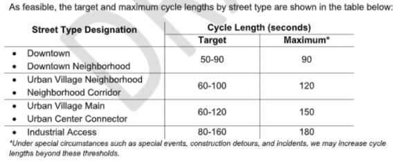
    The policy update includes some benefits that will be seen citywide, but the policy falls short of the promise of revamping signal timing with the goal of moving people over vehicles. A major shortcoming is in the proposed signal lengths, aka the amount of time for a traffic signal to complete a full cycle if you just missed it. Within the middle of Seattle’s densest neighborhoods, a single length of two minutes would be standardized, with a length of even two and a half minutes permitted.

    Cycle lengths would be lowest at intersections along streets downtown, with a target of 50-90 seconds, but a maximum signal length of a minute and a half is still very high for the highest volume streets for pedestrians. Urban village neighborhood streets and neighborhood corridors, which include streets like Broadway in the heart of Capitol Hill (which coincidentally has the highest pedestrian volumes of any street in Seattle in recent years), would be able to have longer signal lengths than in downtown. Streets with an urban village main or urban center connector designation (like Rainier Ave S or College Way N) would be able to have longer cycle lengths still. Industrial access streets like 15th Ave W able to have the longest cycle lengths, up to three minutes.

    Chart showing the different signal lengths as described in the article
    Signal lengths by street type as proposed by SDOT.

    You can use the chart above to match street type designations with this this interactive map to see what the cycle lengths could be on any specific street.

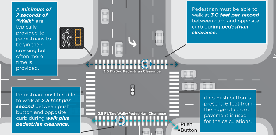
    One factor influencing these proposed cycle lengths is a big change that SDOT is proposing to make all every single intersection in Seattle: reducing the standard pedestrian speed used to calculate how much time is provided to cross from 3.5 feet per second to 3 feet per second. The policy will also include a secondary calculation to ensure that someone standing six feet back from the intersection would be able to cross the street using a speed of 2.5 feet per second and use this to adjust total time provided to cross. This should provide more time to cross most intersections that get revised under the policy.

    Infographic laying out the change from 3.5 feet to 3 feet per second
    This illustration lays out SDOT’s proposed changes to crossing time calculation.

    SDOT says that implementing this policy “should reduce wait times and provide more frequent opportunities for pedestrians to cross the street”, while having the effect of “slight increase in delay and travel time” for transit and freight traffic.

    But the proposed cycle lengths for urban villages and centers exceed the range noted as ideal by the National Association of City Transportation Officials (NACTO), which says “longer signal cycles and corridor-based timing schemes make large avenues into barriers that separate neighborhoods rather than joining them”. NACTO notes that 60-90 seconds is ideal for urban areas. SDOT should reassess whether intersections outside downtown in most cases need to have a targeted signal length of more than a minute and a half, and at a minimum bring down the very high max cycle length.

    Seattle Neighborhood Greenways has set up an action alert on the proposed signal policy’s shortcomings, which you can use to contact SDOT directly here.

    — Advertisement —
  • Segment of Lake Washington Blvd To Reopen December 18-January 4

    SDOT has just announced that it will be closing a small segment of Lake Washington Boulevard between Mount Baker Beach and Stan Sayres Boat Launch (at 45th Ave S) starting this Friday December 18 and running through Sunday January 4. This is the same segment of Lake Washington that was closed over Thanksgiving weekend, and is a shortened segment of the 3-mile Keep Moving street that SDOT piloted over the summer that extended all the way down to Seward Park.

    Another small segment of the street between the boat launch and 50th Ave S is designated “local access” with signage but will still allow vehicles.

    Map showing closed Lake Washington Boulevard
    The segment of Lake Washington Boulevard closed to cars.

    These temporary closures are clearly intended to provide extra open space around holidays but they also serve a transportation need in a segment of town without a reasonable safe north-south bike route. The narrow pedestrian path along Lake Washington boulevard is also inadequate for people who want to maintain six feet from other around them. Many are calling for at least a portion of the street to be made permanently car-free.

    The city continues to have a protracted conversation about the future of Lake Washington Boulevard as a place where people that aren’t in personal vehicles are prioritized. Last week the parks board, which technically controls the land that the street is on, discussed the issue, and the Twitter thread from Erica C. Barnett is worth your time.

    — Advertisement —
  • Seattleites Driving Fewer Miles Than Ever, City Report Suggests

    The city of Seattle just released a new report on our citywide carbon footprint. The info in the report is slightly out-of-date, as it’s a snapshot of how we did in 2018, but is the most comprehensive picture we have of how the city is meeting, or rather failing to meet, its carbon reduction goals.

    The report includes one significant piece of info that should be encouraging to transportation advocates: the number of miles of vehicle travel for each Seattle resident sunk to its lowest level in decades in 2018. Every single Seattle resident’s share of the miles travelled on city streets was just over 6,000 miles after a likely peak of 7,400 in 2005. This is clearly a result of transportation policy decisions, light rail and the success of the Seattle Transit Benefit District central among them, that drove drive-alone commute rates to record lows.

    Chart showing dropping per capita VMT between 2005 and 2018, ending at just above 6000
    Vehicle miles travelled per capita in Seattle since 2005

    Now for the bad news: due to Seattle’s population increasing, total VMT in Seattle is still continuing to go up even as everyone’s individual share is going down. Per capita miles travelled has gone down 11% since 2008 but overall VMT is up 12%.

    Seattle’s goal for miles travelled in the 2013 Climate Action Plan is a 20% drop in overall passenger VMT (separate from freight miles travelled) by 2030. In order to meet the 2030 target, there would need to be a drop of more than 200 million miles per year until 2030.

    (more…)

    — Advertisement —
  • RapidRide J Line Shortening Leaves Roosevelt Bike Connection Hanging

    The recent news that one of the centerpiece transit upgrade projects of the Move Seattle levy, the RapidRide J line- formerly known as Roosevelt BRT- would see its route shortened was another big blow to the transit segment of the levy. Roosevelt BRT will not even reach the Roosevelt light rail station, instead terminating at the U District light rail station. That news comes on the heels of the city giving up entirely on turning 3 current bus routes into RapidRide lines in 2018, and news this year of the route 7’s upgrade being put on hold. The number of broken promises in the transit component of Seattle’s largest-ever transportation levy continues to grow.

    But this is unfortunate news for the hopes of completing a critical bike connection between brand new light rail stations in north Seattle as well. Since 2016, Roosevelt Way NE has had a protected bike lane between NE 65th Street and the University Bridge, just waiting for the light rail station at Roosevelt. But Roosevelt is only a southbound bike lane, and RapidRide J was set to upgrade the paint bike lane on 11th Ave NE, finally completing the couplet. Now it’s not likely that will happen anytime soon.

    The RapidRide J line, including the bike lane component, will not change south of the University Bridge, meaning that a full bike connection along Eastlake Ave is still planned. This will complete a hugely critical connection that will have massive citywide benefits, despite considerable opposition to parking removal along Eastlake. Earlier this year, Mayor Durkan herself voiced clear support for installing protected bike lanes on Eastlake, hopefully indicating that another downgrade isn’t likely.

    Updated route map in the U District for RapidRide J
    The RapidRide J line will terminate at U District Station instead of Roosevelt Station.

    (more…)

    — Advertisement —
  • SDOT Proposes Using Bike Budget to Make Stay Healthy Streets Permanent

    Heavy duty street closed barricade on a Stay Healthy street
    New barricade on the Central District’s Stay Healthy Street

    The Seattle Department of Transportation generated national headlines back in May with an announcement that it would be taking steps to make twenty miles of “Stay Healthy Streets” permanent. This big announcement that a chunk of Seattle’s neighborhood greenway network would get upgrades that make them more enjoyable and safer to use was cheered by many, and for good reason.
    Seattle’s neighborhood greenway network has suffered from inconsistent standards, with little physical infrastructure that prevents people driving cars from utilizing them as an arterial alternative, and little accompanying pedestrian improvements.

    But when that announcement was made earlier this year, we didn’t have a great idea of what those permanent improvements might look like, or what city funding would be used to make them. Last week, a city oversight committee was asked to approve a funding source for permanent Stay Healthy Streets: the existing bike budget.

    A memo written by Jim Curtin, SDOT’s Project Development Division Director, asks the Move Seattle levy’s oversight committee to approve use of levy dollars for the upgrade of Stay Healthy Street using “durable materials”. It states that these upgrades will “improve safety on Stay Healthy Streets and support a community driven process that was not possible during the initial COVID-19 emergency response”, citing a 357% increase in people walking and a 111% increase in people biking along the Stay Healthy Streets since they were implemented. (According to the same memo, regular neighborhood greenways only saw a 37% increase in people biking compared to a normal neighborhood street.)

    In return, more than two and a half miles of new neighborhood greenway projects would lose construction funding. This would further reduce the amount of bike facilities installed over the life of the 9-year Move Seattle transportation levy. A recent report to the oversight committee listed fewer than 35 miles of either protected bike lanes or neighborhood greenways completed to date compared with the 110 miles that were promised to voters in 2015. The bike master plan program is expected to fall well short of its goal already.

    (more…)

    — Advertisement —
  • Welcome Temporary Editor Ryan Packer

    Photo of Ryan Packer with a bicycle in a park.
    Ryan Packer

    I am very excited to announce that Ryan Packer will be Temporary Editor of Seattle Bike Blog now through the end of February.

    As readers of The Urbanist know, Ryan is a very thorough reporter with a deep understanding of how transportation policy works (and fails to work) in Seattle. So I was very excited when they applied for the Editor job.

    Ryan Packer (they/them) has lived in Seattle for about fifteen years, originally hailing from northern Illinois. Since 2015, they have reported on transportation, particularly on Vision Zero and pedestrian & bicycle infrastructure, at The Urbanist. In normal times, they spent a lot of free time going to see the work of Seattle’s amazing live theater artists and is looking forward to doing that again very soon. To get in touch, email [email protected] or follow @typewriteralley on Twitter.

    As for me, I am taking a sabbatical from the blog after more than a decade. Site content has been very slow lately as I work to complete the first draft of a book about Seattle bike culture for UW Press. Hiring Ryan will be great for Seattle Bike Blog, bringing important news back to the site in a more timely manor. It will also give me more time and space to focus on this book.

    Businesses can support this effort by advertising, and readers can support by signing up for the monthly Seattle Bike Blog Supporter program.

    Thank you all for reading, and thanks Ryan for signing on!

    — Advertisement —
— Advertisement —

Join the Seattle Bike Blog Supporters

As a supporter, you help power independent bike news in the Seattle area. Please consider supporting the site financially starting at $5 per month:


Latest stories

Bike Events Calendar

Jul
25
Thu
7:15 pm Point83 @ Westlake Park
Point83 @ Westlake Park
Jul 25 @ 7:15 pm
Point83 @ Westlake Park
Meet up in the center of the park at 7ish. Leave at 730. Every Thursday from now until forever rain or shine. Bikes, beers, illegal firepits, nachos, bottlerockets, timetraveling, lollygagging, mechanicals, good times.ShareMastodonTwitterFacebookRedditEmail
Jul
27
Sat
all-day Bicycle Weekends on Lake Washing…
Bicycle Weekends on Lake Washing…
Jul 27 – Jul 28 all-day
Bicycle Weekends on Lake Washington Blvd
Details from Seattle Parks: On scheduled weekends from May to September, a portion of Lake Washington Boulevard will be closed to motorized vehicles from 10 a.m. Saturday to 6 p.m. Sunday. “Seattle Parks and Recreation[…]
1:00 pm Seattle Queer History Ride 2024 … @ Volunteer Park (Black Sun sculpture)
Seattle Queer History Ride 2024 … @ Volunteer Park (Black Sun sculpture)
Jul 27 @ 1:00 pm – 4:30 pm
Seattle Queer History Ride 2024 - Capitol Hill to University District (Leisurely) @ Volunteer Park (Black Sun sculpture) | Seattle | Washington | United States
Join me for a 7 mile bike ride going from Capitol Hill into the University District at a Leisurely pace. We’ll visit various sites relevant to Seattle’s current gayborhood and gathering sites around UW.ShareMastodonTwitterFacebookRedditEmail
Jul
28
Sun
all-day Bicycle Weekends on Lake Washing…
Bicycle Weekends on Lake Washing…
Jul 28 – Jul 29 all-day
Bicycle Weekends on Lake Washington Blvd
Details from Seattle Parks: On scheduled weekends from May to September, a portion of Lake Washington Boulevard will be closed to motorized vehicles from 10 a.m. Saturday to 6 p.m. Sunday. “Seattle Parks and Recreation[…]
Aug
1
Thu
7:15 pm Point83 @ Westlake Park
Point83 @ Westlake Park
Aug 1 @ 7:15 pm
Point83 @ Westlake Park
Meet up in the center of the park at 7ish. Leave at 730. Every Thursday from now until forever rain or shine. Bikes, beers, illegal firepits, nachos, bottlerockets, timetraveling, lollygagging, mechanicals, good times.ShareMastodonTwitterFacebookRedditEmail
— Advertisements —

Latest on Mastodon

Loading Mastodon feed…