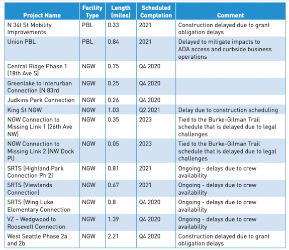
Last fall, SDOT released a report on the future of transportation in the vicinity of Interbay and Ballard. The result, the Ballard-Interbay Regional Transportation System (BIRT) report, focused on the big topics of what to do about the Magnolia and Ballard bridges, both on a timeline to replacement, but it also looked at the projects needed to better enable to get around the area without a car, of which there are many.
There are so many moving pieces around what happens next, we got a few people who have been following the topic closely together and talked about what the BIRT report means and what its impact is likely to be. The discussion ended up venturing into a larger discussion about transportation and land use in Seattle.
In the conversation:
Laura Loe is a NW Queen Anne Renter, a Magnolia P-Patch gardener, and has nervously ridden a bike less than two dozen times.
Ray Dubicki is a stay-at-home dad and parent-on-call for taking of tasks around Ballard. He is an attorney and urbanist by training, with soup–to–nuts experience in planning and law. He enjoys using PowerPoint, but only because it’s no longer a weekly obligation.
Mark Ostrow once had a long conversation with Bobby McFerrin at a brasserie in Paris. His tweets, which are legendary, can be found at @qagreenways.
The conversation has been edited for clarity and for length.
Seattle Bike Blog: So, I just want to ask this group what BIRT is, as an introductory question.
Ray: BIRT is…
Laura: A blank check for climate destruction.
Ray: Yeah, exactly.
Laura: It’s a blank check for climate destruction!
Ray: BIRT is a study that the state mandated in 2019 that took an entire year for the City of Seattle to write…
Laura: And it was seven hundred thousand dollars.
Ray: And in that year they left out parts of Interbay in order to support rebuilding two billion dollar bridges, so a total of two billion dollars worth of bridges, and not taking into account all of the other parts of the infrastructure equation that are in Interbay, such as rail, bikes, pedestrians, transit.
There are some very cute accessory things that go along with those two billion dollar bridges that they call pedestrian infrastructure. But really, it is bending pedestrian infrastructure and transit infrastructure to the service of these giant highways running through the city.
Mark: Yeah, it’s really clear that the highway is the main part of what they’re trying to build there. Anytime you look at pedestrian infrastructure or bike infrastructure, it always just winds around the car stuff like a pretzel.
Laura: So I think your readers should understand who’s in control here. The people that are in control are the BNSF [railroad], the Ports, the maritime industry and the freight industry. They have the power in this region. So it’s not a normal conversation about, like, the Roosevelt protected bike lane. We are dealing with forces way different than a Roosevelt protected bike lane situation. You’re dealing with national freight companies, national railway, ports. Ports have so much power, so much power to shape this.
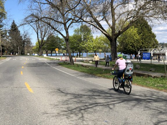
And so all those forces are so big in comparison with just a little ant walking over the Emerson interchange or a little ant walking over Dravus [Street] or a little bike rider crossing the Ballard bridge and having to do this weavy-ass stupid thing to get to the other side. Like we are so minimized in the economic forces, the capitalist forces, not to make this about capitalism, but this is about the ports and the maritime industry and the freight industry wanting not one thing that will slow their economic engines.
Mark: Yeah, I mean, not just that, but the military as well. They were mandated to be major stakeholders in this entire process. So it’s kind of the capitalist military industrial complex. And we’re just trying to cross the bridge, you know, to get to a brewery. And I think that we’re way the heck down the list of priorities.
Laura: The little chicken is trying to cross the road.