— Advertisement —
  • What’s the deal with BIRT? A conversation

    Last fall, SDOT released a report on the future of transportation in the vicinity of Interbay and Ballard. The result, the Ballard-Interbay Regional Transportation System (BIRT) report, focused on the big topics of what to do about the Magnolia and Ballard bridges, both on a timeline to replacement, but it also looked at the projects needed to better enable to get around the area without a car, of which there are many.

    There are so many moving pieces around what happens next, we got a few people who have been following the topic closely together and talked about what the BIRT report means and what its impact is likely to be. The discussion ended up venturing into a larger discussion about transportation and land use in Seattle.

    In the conversation:

    Laura Loe is a NW Queen Anne Renter, a Magnolia P-Patch gardener, and has nervously ridden a bike less than two dozen times. 

    Ray Dubicki is a stay-at-home dad and parent-on-call for taking of tasks around Ballard. He is an attorney and urbanist by training, with souptonuts experience in planning and law. He enjoys using PowerPoint, but only because it’s no longer a weekly obligation.

    Mark Ostrow once had a long conversation with Bobby McFerrin at a brasserie in Paris. His tweets, which are legendary, can be found at @qagreenways.

    The conversation has been edited for clarity and for length.

    Seattle Bike Blog: So, I just want to ask this group what BIRT is, as an introductory question.

    Ray: BIRT is…

    Laura: A blank check for climate destruction.

    Ray: Yeah, exactly.

    Laura: It’s a blank check for climate destruction!

    Ray: BIRT is a study that the state mandated in 2019 that took an entire year for the City of Seattle to write…

    Laura: And it was seven hundred thousand dollars.

    Ray: And in that year they left out parts of Interbay in order to support rebuilding two billion dollar bridges, so a total of two billion dollars worth of bridges, and not taking into account all of the other parts of the infrastructure equation that are in Interbay, such as rail, bikes, pedestrians, transit.

    There are some very cute accessory things that go along with those two billion dollar bridges that they call pedestrian infrastructure. But really, it is bending pedestrian infrastructure and transit infrastructure to the service of these giant highways running through the city.

    Mark: Yeah, it’s really clear that the highway is the main part of what they’re trying to build there. Anytime you look at pedestrian infrastructure or bike infrastructure, it always just winds around the car stuff like a pretzel.

    Laura: So I think your readers should understand who’s in control here. The people that are in control are the BNSF [railroad], the Ports, the maritime industry and the freight industry. They have the power in this region. So it’s not a normal conversation about, like, the Roosevelt protected bike lane. We are dealing with forces way different than a Roosevelt protected bike lane situation. You’re dealing with national freight companies, national railway, ports. Ports have so much power, so much power to shape this.

    And so all those forces are so big in comparison with just a little ant walking over the Emerson interchange or a little ant walking over Dravus [Street] or a little bike rider crossing the Ballard bridge and having to do this weavy-ass stupid thing to get to the other side. Like we are so minimized in the economic forces, the capitalist forces, not to make this about capitalism, but this is about the ports and the maritime industry and the freight industry wanting not one thing that will slow their economic engines.

    Mark: Yeah, I mean, not just that, but the military as well. They were mandated to be major stakeholders in this entire process. So it’s kind of the capitalist military industrial complex. And we’re just trying to cross the bridge, you know, to get to a brewery. And I think that we’re way the heck down the list of priorities.

    Laura: The little chicken is trying to cross the road.

    (more…)

    — Advertisement —
  • Green Lake Keep Moving Street to shrink by half as southbound lane reopens

    As early as next week, the Keep Moving Street in place on a portion of West Green Lake Way N, allowing space for people to more comfortably walk, bike, and roll apart from vehicles, will shrink by half as the Seattle Department of Transportation reopens its southbound lane to vehicle traffic. According to SDOT, this change is being made to allow people driving to access both the parking lot at the Green Lake Park tennis court and the Lower Woodland Park off-leash area parking lot.

    This Keep Moving Street was the second most utilized open street in 2020 on a per-mile basis according to SDOT’s data, second only to Beach Drive in West Seattle. SDOT will be installing barriers to separate the newly reopened travel lane from the lane devoted to walking rolling and biking, but we don’t yet know what kind of barriers those will be.

    Green line connecting East Green Lake Way N with N 63rd Street between Woodland Park and Green Lake Park.
    Map showing the Keep Moving Street at Green Lake.

    Scaling down the Stay Healthy Street to restore access to parking will be frustrating to many who have enjoyed it, but hopefully this opens up an avenue to its conversion into a long-term facility. Later this year, SDOT will open a bike facility on the other side of Green Lake Drive/Way, between Stone Way and Densmore Ave at the very north end of the lake.

    Permanently converting the lakeside lane where the Keep Moving Street exists now would continue that facility even further around Green Lake. By itself this would be nice, but it would also set up the future possibility of a safe bike route all the way around the lake that’s separate from the loop trail.

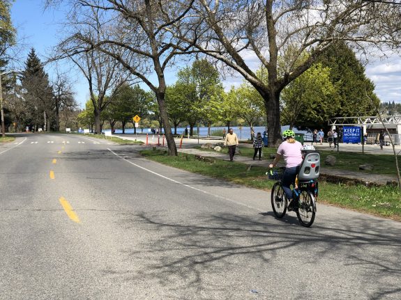
    Person on bike with empty kid carrier on back on empty Keep Moving Street
    Green Lake Way’s Keep Healthy Street last Summer. (Tom Fucoloro)

    Along the very western edge of Green Lake Park is Aurora Ave. A substandard gravel path is the only way to navigate this stretch if you’re walking; if you’re rolling it’s pretty much inaccessible. Paired with the fast moving traffic on Aurora it’s a recipe for disaster. In 2019, a UW student, Bergen Fuglestad, was struck by a driver while jogging along this path. That collision resulted in what is likely to be permament injury to Fuglestad.

    Converting the curbside lane on Aurora next to Green Lake Park could make everyone safer.

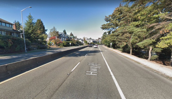
    The rightmost lane of Aurora here is incredibly underutilized. Converting it into a bike facility protected by jersey barriers (as exist in the median of Aurora here) would protect the walking path and complete another segment of the full bike connection around Green Lake. It also would likely slow most drivers a bit more at that segment. Installing barriers on the south end of the lake this month will be a great way to pilot it.

    SDOT says they envision the Green Lake Keep Moving Street staying in place longer than other Keep Moving Streets because of the restriction on bikes using the Green Lake path. Hopefully longer in this case means permanent.

    — Advertisement —
  • Report details how much catching up Seattle has to do in 2021 on bike lanes

    A report completed by the Seattle Department of Transportation in December but not released until this week shows how much catching up the department is planning to do in 2021 to complete installing bike facilities that it had originally planned to install last year. This report is the most recent update on SDOT’s progress on building Seattle’s citywide bicycle network since the recalibration of the construction plan for the remainder of the Move Seattle levy through 2024 was completed in 2019.

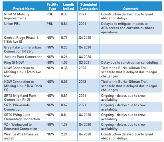
    According to the report, only 2.3 miles of protected bike lanes or neighborhood greenways were completed through the third quarter of 2020, compared to the original plan for the year of 15.2 miles set in 2019. The ones that were installed were almost all big achievements, it must be noted. These were the Avalon Way PBL in West Seattle. the first phase of the 4th Ave PBL downtown, a Yesler Way PBL between 12th and 14th Ave, and a neighborhood greenway on Capitol Hill connecting Lowell Elementary School and Meany Middle School. SDOT is also counting the Lander Street Overpass as bicycle infrastructure in the report, which certainly makes it the most expensive trail constructed in Seattle at $100 million for one quarter mile.

    Another 6 miles of PBLs and greenways were scheduled to be completed by the end of the year, but the majority of those projects didn’t achieve that deadline and were pushed into 2021. One project, the completion of the Pike Street protected bike lane between 6th and 9th Ave downtown, was essentially cancelled after originally being scheduled for last year. It’s now only scheduled to be completed with the rest of the permanent Pike and Pine PBLs installed as part of the Pike/Pine Renaissance in 2023.

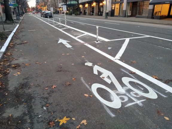
    The first phase of the 4th Ave protected bike lane downtown was completed in 2020.

    That means SDOT is planning to complete around 11 miles of neighborhood greenways or protected bike lanes this year that were originally planned for last year, on top of what was originally scheduled for 2021. In an assessment of the impact of the Covid-19 crisis on the entire department published this year, SDOT said they were on track to complete 50-55 miles of bike facilities, including painted bike lanes, by the end of the levy in 2024. This is half of what was promised to voters in 2015.

    We don’t yet know what impact the delay in project delivery in 2020 will have on projects scheduled for 2021 and beyond. Traditionally, every spring the Bicycle Master Plan’s implementation schedule would be reviewed by the city council’s transportation committee, something that didn’t happen in 2020 due to the Covid emergency. It’s also not clear that reviewing the bicycle master plan’s implementation is a priority of Alex Pedersen’s transportation committee.

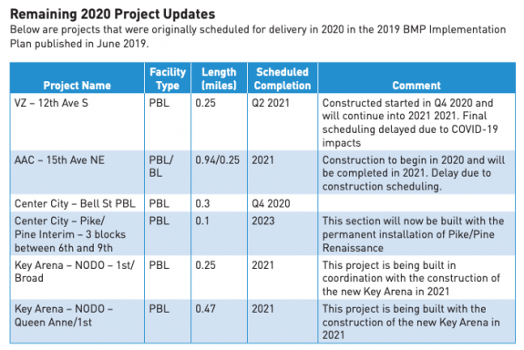
    Below is the list of 2020 projects that are set to be (mostly) completed in 2021 or later.

    Hopefully we can get a more complete picture on the status of the program before too many additional months of 2021 progress. You can read the full 2020 status report report here.


    — Advertisement —
  • Watch SDOT’s virtual tour of the Duwamish Trail connection & crossing improvements

    The Seattle Department of Transportation continues outreach around its proposal to finally connect the last segment of the Duwamish Trail between the West Seattle Bridge and the separated trail that starts a half mile down West Marginal Way SW.

    A Virtual Open House around all the improvements planned for the street is planned for next Thursday, February 18th at 6pm, with the fate of the protected bike lane project the most significant decision left to be made. Duwamish Valley Safe Streets and West Seattle Bike Connections have already voiced their support for connecting the trail, with the Freight Advisory Board and the Port of Seattle being the primary opponents of taking away street space for the lane.

    Last week the Bicycle Advisory Board was told by SDOT’s Bradley Topol that if the proposal to convert a westernmost lane of Marginal to a two-way protected bike lane was approved, the department currently plans to separate the bike facility from the rest of Marginal with either concrete barriers or planters, not just paint and plastic posts. Prior to this, we hadn’t heard what was planned to be able to make people biking northbound, with drivers coming southbound in the next lane, more comfortable.

    In advance of the virtual open house, SDOT has released an online walking tour of West Marginal that does a great job of illustrating what the improvements would entail and why they are needed. Check out the video below!

    — Advertisement —
  • Segment of Lake Washington Boulevard to reopen for Winter, Spring breaks UPDATED

    Update: due to the anticipated snow event this weekend, the closure of Lake Washington Boulevard outlined below has been postponed to Monday February 15. It will run through Sunday the 21st as planned. 

    A stretch of Lake Washington Boulevard just south of Mount Baker Beach will open to people walking, biking, and rolling starting this Friday February 12 Monday February 15 through Sunday February 21, Seattle Public Schools Winter Break, as well as April 9th through the 18th, for SPS Spring Break. The street will be closed to vehicles between Stan Sayres Boat Launch and Mount Baker Beach during that time.

    Map showing closure to vehicles from Mount Baker Beach to Stan Sayres Memorial Park.
    A short segment of Lake Washington Boulevard south of Mount Baker Beach closes for Winter and Spring breaks.

    This is the same stretch of Lake Washington Boulevard closed to people driving during the winter holidays last year, and doesn’t extend all the way south to Seward Park like the Summer 2020 closure did.

    This closure sets the stage for another Summer-long open street on Lake Washington Boulevard but begs the question: if we can open it for a week at a time, why not indefinitely, at least for this year? People who use this route for transportation, given the lack of dedicated bike facilities parallel to it, don’t disappear at the end of school breaks.

    The full Lake Washington Boulevard closure last Summer was the third-most-used Open Street in the city behind West Seattle’s Beach Drive and Green Lake Drive in North Seattle. The idea of permanently closing it to vehicle traffic, which we have done before with Interlaken Boulevard in north Capitol Hill (another Olmsted legacy route), remains hotly contested. Any path to a change in use would go through the Seattle Parks board, which has control over the street since it technically rests on park property.

    In the meantime, we’ll enjoy every weeklong closure we can get.

    Read more about the overall Keep Moving Street and Stay Healthy Street program here.

    — Advertisement —
  • Watch out! Speed bumps added to Roosevelt Way bike lane near 43rd. UPDATE 2/5: They’re gone

    UPDATE (2/5, 1:45 p.m.): The bumps are gone.

    UPDATE (2/5): The speed bumps will be removed. This morning we received an update from SDOT’s Ethan Bergerson:

    I want to give you an update that we are planning to remove this speed bump. Our City Traffic Engineer Dongho Chang personally inspected the location yesterday afternoon and, while the speed bump complied with official design standards, he felt that it was still best to remove it given the concerns we were hearing from riders because we want people to feel comfortable riding on our protected bike lanes. We’re considering other possible safety measures for this location, in addition to the safety features and signage that we have already installed.

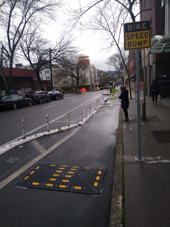
    Original post: Without any advance warning, the Seattle Department of Transportation has added “speed bumps” to the Roosevelt Way NE protected bike lane around the bus stop island near N 43rd Street. The two bumps are plastic with reflective tape on them, and come up fast on people biking. Per Dongho Chang, City Traffic Engineer, the bumps were installed in reaction to at least one bad collision between someone biking at fast speed and someone using the drop-off space here for UW Medicine.

    Plastic bike speed bump in front of sign labelled Bike Speed Hump
    The bike speed hump was installed in the past few days

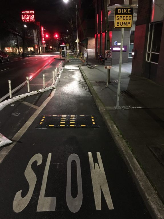
    We went out to inspect the bike speed hump after a reader tip came in overnight by reader Bob Vosper who didn’t see the bumps last night until the last second and ended up flipping over his bike. Thankfully, Bob’s okay. He sent us a photo of how the bumps look at night.

    Bike speed hump seen above at night

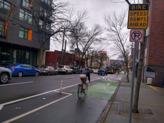
    There’s an advance warning sign a bit before the sign right next to the bump, but that advance sign is a lot higher off the ground. Dongho Chang told me that’s due to MUCTD (Manual on Uniform Traffic Control Devices) standards for sign height. But it may end up out of the field of vision for someone biking down Roosevelt at night with a bike light aimed lower.

    person biking along next to advance warning sign for Bike Speed Humps Ahead

    Chang was out inspecting the speed bumps today while we were checking it out, and told us they plan to replace the plastic dome with an asphalt hump like the ones more common around town. He also thought there were some immediate tweaks they could make to the approach to give people biking more warning that they’re coming up on a hazard.

    More from SDOT’s Ethan Bergerson:

    “We can say that this was one of several tactics intended to improve safety near the bus stop, loading zone, and main entrance to UW Medical Center a few feet down the road. People, including many hospital patients, need to cross over the bike lane in order to reach the bus stop and loading zone. In addition to being busy King County Metro bus stop, this is also the loading zone for several forms medical transportation such as King County Metro Access, DART, Hopelink Medicaid Transportation, and UW Medicine hospital shuttles.”

    Bike/pedestrian collisions are a lot more rare than vehicle/pedestrian collisions, but if there was a hotspot in Seattle for crashes like this, it would be here. SDOT’s collision database shows at least 3 recorded collisions here since 2018. However, the design here looks like it makes the protected bike lane more dangerous for people biking. It seems like the best fix here would be to remove this plastic bump, which isn’t like anything currently in a PBL in the city, until another fix can be put in place.

    — Advertisement —
— Advertisement —

Join the Seattle Bike Blog Supporters

As a supporter, you help power independent bike news in the Seattle area. Please consider supporting the site financially starting at $5 per month:

Latest stories

— Advertisements —

Latest on Mastodon

Loading Mastodon feed…