— Advertisement —
  • 4th Ave protected bike lane downtown to be extended this Spring

    This week SDOT told the Bicycle Advisory Board that an extension of the 4th Avenue protected bike lane downtown, to both the north and the south, is moving forward with construction planned for this Spring. With those extensions, the entire facility will be converted to a two-way bike lane compared to the current configuration which is only two-way in central downtown.

    At the meeting, SDOT provided a closer look at the planned design of the lanes. To the north, the PBL will be extended from Bell to Vine Street, adding protected left turn signals to separate people riding bikes from turning drivers. We haven’t seen what the end of the bike line looks like at Vine (probably a green bike box to make a right turn onto Vine), but the northern extension as a whole should look pretty much like it does in the rest of Belltown currently.

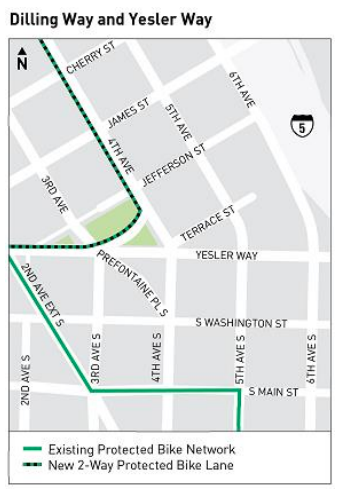
    It’s the south end where things will get a little tricky. The lane on 4th Ave is only planned to go to Dilling Way. What’s Dilling Way? It’s just north of Yesler, the curved street that connects 4th and 3rd right next to City Hall Park. SDOT is planning a two-way PBL on the north side of Dilling Way, retaining parking on the south side of the tiny street.

    Map showing planned connection on Dilling between 4th and 3rd
    4th Ave will connect to the rest of the bike network via Dilling Way.

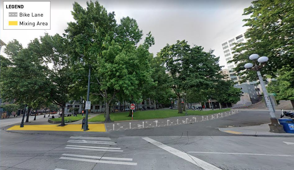
    At 3rd Avenue, people riding will use a ramp to access the sidewalk to queue for the light to change. This is probably the most unfortunate element of this planned connection: routing a bike facility onto a sidewalk should be avoided at all costs. This is pretty reminiscent of the plan for the north end of the 2nd Ave PBL, except this is right in the middle of the route, not the end. SDOT said they are planning on doing some work to improve the sidewalk here, but this will particularly impact blind and low-vision pedestrians who are not expecting to be walking in a bike mixing space.

    Bike lane coming from 4th ave on right side turns into yellow "mixing area" on sidewalk at 3rd and Yesler
    Rendering of SDOT’s planned connection between 4th Ave and 2nd Ave on Dilling Way.

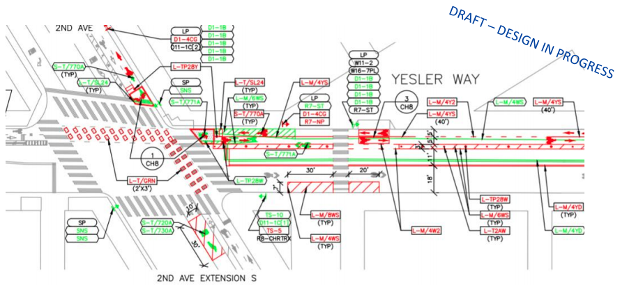
    Here’s a closer look at the plans for this segment, via a draft design document presented this week. You can see in the diagram that people riding bikes will use a ramp to enter and exit the 3rd and Yesler sidewalk that is separate from the ADA ramp. The crosswalk across 3rd will be completely redone to make it wider to accommodate people walking, rolling, and biking.

    Blueprints showing Dilling Way and 3rd Ave as described
    Plan for the protected bike lane on Dilling Way to connect across 3rd Ave and Yesler Way. (Click to enlarge)

    On the block between 3rd Ave and 2nd Ave, the two-way PBL stays on the north side of the street, connecting with the 2nd Ave PBL and the Yesler stub lane currently in place on the other side of 3rd Ave. Eventually this will connect all the way to the Waterfront bike route but funding hasn’t been secured for that short connection yet.

    Blueprints showing Yesler Way between 3rd and 2nd Ave as described
    Plan for Yesler Way’s protected bike lane between 2nd Ave and 3rd Ave. (Click to enlarge)

    Why isn’t the 4th Ave PBL connecting with the already installed bike lanes in Pioneer Square on Main Street? SDOT contends that a bike lane between Yesler and Main isn’t feasible because of the volumes of buses that use the corridor. The connection is eventually planned, SDOT says, but not until 2023 or 2024, after both the Northgate and East Link light rail extensions convert more bus trips to light rail trips.

    The installation of a two-way facility on most of 4th Ave this year will be a huge win, given the fact that delaying this bike lane was one of Mayor Durkan’s first acts on taking office.

    — Advertisement —
  • Stay Healthy Streets program may be paused if funding swap not approved

    Last night the oversight committee for the Move Seattle levy was told that the popular Stay Healthy Streets program will likely have to pause if the Seattle Department of Transportation doesn’t get approval to divert funding from 2.5 miles of neighborhood greenway projects that the department says it’s unlikely to be able to fully complete in the foreseeable future.

    In January, the joint Pedestrian and Bicycle Advisory Boards voted essentially unanimously not to divert funding from existing planned bike and street improvements to fund the promise that SDOT and Mayor Jenny Durkan announced last Summer to install permanent infrastructure on twenty miles of Stay Healthy Streets.

    SDOT’s Director of Project Development, Jim Curtin, told the committee that the funding source that the department had originally used to stand up and maintain Stay Healthy Streets in 2020, Federal CARES Act funding, has now run out, and that any additional funds used to support the program will be coming from Bicycle Master Plan funding.

    The oversight committee did not reach a consensus on whether to approve the funding swap, asking to come back to another meeting to discuss it further. Curtin told the board that if they didn’t find a source for funding, they would have to pause planning future improvements and have to look at whether the department could continue to maintain existing Stay Healthy Streets at all.

    A current barrier on a Stay Healthy Street.

    (more…)

    — Advertisement —
  • Senate chair’s transportation package includes bike tax, less in multimodal investments

    Senate Transportation Chair Steve Hobbs

    A week after the Washington House Democrats unveiled their proposed transportation package, which would fund bike, pedestrian, and transit programs at a level never before seen from the state, the chair of the state Senate’s transportation committee, Steve Hobbs, unveiled his counterproposal last week. This package is different than the one the committee’s vice-chair Rebecca Saldaña proposed before the start of the session. The Hobbs proposal would invest billions of dollars less in multimodal transportation than the House package and billions more in statewide highway expansion.

    The Senate proposal also includes a line item that shouldn’t have seen the light of day: a special sales tax increase of 1% on bicycles. This ridiculous extra bike charge would raise a grand total of 0.1% of the revenue generated by the entire package over its 16-year life. Senator Hobbs has proposed this bike tax as part of his transportation package during the last two legislative sessions as well, but there hasn’t been enough momentum to pass it in recent years and no significant counterproposal. A “symbolic” bike tax has actually been kicking around the legislature for years, including a 2013 flat $25 bike tax proposal. This bike tax would be less than that previous versions on all bikes under $2500, but the exploding e-bike market means a lot of bikes that can serve as a car replacement exist above that price point.

    Currently Washington State offers a sales tax exemption on up to $25,000 on the sale of a new electric car, in addition to tax credits offered by the Federal government. This has prompted Rep. Sharon Shewmake to propose a similar sales tax exemption for e-bikes. This would add an extra cost to the purchase price of all types of bikes. This is a blow bike shops do not need right now.

    The bulk of the revenue raised for the package would come from either a carbon tax or a cap-and-trade proposal, both of which are being debated in other committees in the legislature right now. It would only raise the state’s gas tax by 6 cents (compared to 18 cents in the House proposal) and unlike the House proposal would not index the gas tax to keep up with inflation.

    On the spending side, the package includes over $2 billion more in highway expansion projects, an amount that matches nearly exactly the reduction in multimodal transportation grants compared to the House proposal. It also invests $2 billion less in preserving and maintaining the state’s transportation infrastructure, kicking the can even further down the road and setting up more fights to secure more needed transportation funding later.

    Huge freeway bridge crossing an island with interchanges and ramps everywhere
    Columbia River Crossing project replacing I-5 between Washington and Oregon.

    The highway expansion projects include many projects that have been on the wishlists of state legislators from all over, including $1.2 billion for the next iteration of the Columbia River Crossing, $1.4 billion for the Highway 2 trestle in Snohomish County, and dozens of other projects. While the Washington State Department of Transportation has explored prioritizing projects based on data like multimodal system development, this list comes straight from negotiations between lawmakers.

    (more…)

    — Advertisement —
  • Proposed modal integration policy would dismantle the Bicycle Master Plan

    Seattle’s Complete Streets ordinance turns 14 years old this year. Since becoming one of the first major American cities to codify in city law the idea that all major transportation improvements should include accommodations for all types of street users, the city has struggled to actually put this into practice. Loopholes allowed individual projects to be exempt from the ordinance. In 2019, after SDOT made it crystal clear how toothless the ordinance was by completing a Complete Streets checklist on 35th Ave NE in Wedgwood (after the department redesigned the street to include no bike facilities at the direction of the Mayor), the City Council passed another law requiring major repaving projects to include bike facilities if they are designated on the Bicycle Master Plan.

    Now, it looks like the Seattle Department of Transportation is ready to throw in the towel on the Bicycle Master Plan entirely, and along with it all of the plan’s goals and benefits, under the guise of integrating all of the City’s modal plans together.

    Last Thursday SDOT held its final meeting with the Policy and Operations Advisory Group (POAG) and presented a finalized draft “modal integration policy framework”. We previewed this framework after the group’s last meeting in December. According to the department, it was developed to create policy guidance on integrating the bicycle, transit, freight, and pedestrian master plans. It focuses on areas where the right of way is “deficient”, meaning that according to SDOT’s own design standards (as laid out in its Streets Illustrated Right-of-Way improvement manual) there isn’t enough room to accommodate all modes on a specific city block. “Even with a large policy foundation, we lack comprehensive policy guidance for how accommodate these networks in places where the [street] is too narrow for all desired modes and uses,” the policy’s executive summary states.

    An image of street space allocation as recommended by the Streets Illustrated manual.

    That executive summary, which is the most detailed summary of the policy that we’ve seen so far, makes it even more clear that the adoption of this policy would specifically target the Bicycle Master Plan over the other modal plans. Across the three adopted modal plans (with the Pedestrian Master Plan analyzed separately), it cites 5,269 segments of bike lane, transit lane, or freight lane intended to fit within the space available from one curb to another. SDOT says 8% of them, or 440 blocks, are not wide enough to accommodate all of the modes specified as needing space in their respective plans. Amazingly, all but one of those 440 includes a planned bike facility. On half of those blocks (223), the bicycle facility is the only thing even competing for extra street space- no transit lanes or freight lanes are even conceived on those blocks.

    In other words, if the Bicycle Master Plan didn’t exist, there would be one block of conflict between Seattle’s modal plans over the use of the curb-to-curb space on our streets.

    In addition, there are another 1,208 street segments where a planned bike, freight, or transit lane fits in the street space only if a turn lane or a flex lane (parking, loading, peak hour travel) were removed. Again, this is almost entirely (598 of these) a bike facility all by itself. The policy states that flex lanes “in some cases, should be prioritized in right-of-way allocation decisions, and should be evaluated more consistently within concept design processes”.

    (more…)

    — Advertisement —
  • Trail Alert: 520 underpass in Montlake closed for two more weekends UPDATED

    UPDATE: the closure planned for February 5-8 is no longer happening due to a change in work. The highway will be closed but the pedestrian and bike trail will remain open. The next trail closures are February 26-March 1 and March 5-8.

    Aerial photo with the walking and biking path drawn on it.
    This connection will be closed for four weekends.

    The Washington State Department of Transportation is starting work on installing the Montlake freeway lid this weekend, the first of four weekend closures that will close the bike and pedestrian path underneath 520 from Friday at 11pm to Monday at 5am.

    These closures will be:
    January 29-Feb 1, 11pm to 5am
    February 26-March 1, 11pm to 5am
    March 5-8, 11pm to 5am

    Montlake Boulevard will be the primary choice for people biking to get between the Montlake Neighborhood and the Montlake bridge during the closure, though the Bill Dawson trail on the west side of Montlake Boulevard connecting to Montlake Playfield remains open. The pedestrian and bike trail across the lake adjacent to 520 will not close.

    You can watch a video from WSDOT explaining the work they are doing to create a lid over 520 at Montlake.


    — Advertisement —
  • Seattle continues to stagnate on preventing traffic deaths even as total collisions plummet

    Preliminary data on traffic collisions from last year shows that the total number of collisions involving people on bikes in Seattle was down by more than 50% compared to the average of the three previous years. This follows the trend in overall traffic crashes, which SDOT says went from 230 per week to 115 in 2020.

    One big footnote here is that this data is always unreliable; absolutely more so in 2020 as the number of people who would be hesitant to file a report with the Seattle police increased and the police side was more likely to deem something else a higher priority. But it’s the best we have to get a snapshot into what happened on our city’s streets last year.

    Even as traffic collisions fell, the overall number of people who lost their lives in traffic last year did not decline as well. Preliminary numbers show 24 people were killed in the year, as noted by the Seattle Times earlier this week, a number only matched in recent years by 26 fatalities in 2019.

    Zig zagging line starting at 23 in 2013 and ending at 24 in 2020

    Fourteen of the twenty-four people who were killed on Seattle’s streets last year were using our streets for walking or biking. This is a continuing trend, where a larger and larger percentage of fatalities are people using active transportation.

    The citywide reduction in speed limits on arterials that was put into high gear in the fall of 2019 is being cited as a success story by SDOT: they note a “20-40% drop in the number of crashes in locations with new 25 mph signs”, which they say was observed before the drop in traffic volumes seen last March. But that report only looked at North Seattle locations, and few high-crash corridors.

    At Rainier Ave and S Holly, where the Mayor unveiled the initial 25 mph sign at her 2019 press conference, an October 2020 speed study showed 91% of drivers in either direction were going above the speed limit, with 61% of drivers going over 30 mph on the street.

    Mayor Durkan pointing at a new speed limit sign
    Mayor Durkan unveils a 25 mph speed limit sign on Rainier Ave in 2019

    That lines up with data from another very frequent crash corridor, Aurora Ave N, which hasn’t seen speed limit changes recently but where data shows that drivers are frequently exceeding the speed limits. Both Rainier Avenue and Aurora Avenue saw traffic fatalities in 2020. All signs to point to more robust traffic design overhauls needed on Seattle’s busiest corridors, even if speed limit signs may have an impact on the less busy corridors.

    Statewide Washington saw higher traffic fatalities than it did in all but one year in the past decade: 560 people across the state died in traffic violence, or one approximately every sixteen hours in 2020. WSDOT Secretary Roger Millar has attributed this trend to people speeding, citing an individual driver going way over the speed limit in Snohomish County on I-5. But simply using one explanation ignores all of the areas of opportunity, including the ones laid out by WSDOT itself in its Active Transportation plan.

    Blue bars leading up since 2008 with 560 fatalities in 2020
    Year over year traffic fatalities were up 4.1% in Washington as a whole last year.

    Next month will mark six years since Seattle’s Vision Zero pledge, with not much to show for it. Washington State as a whole has been signed on to that pledge since 2000. We are heading the wrong direction, and it’s going to take real investment to change the dynamic.

    — Advertisement —
— Advertisement —

Join the Seattle Bike Blog Supporters

As a supporter, you help power independent bike news in the Seattle area. Please consider supporting the site financially starting at $5 per month:

Latest stories

— Advertisements —

Latest on Mastodon

Loading Mastodon feed…