— Advertisement —
  • Local groups speak up in favor of protected bike lane on West Marginal Way

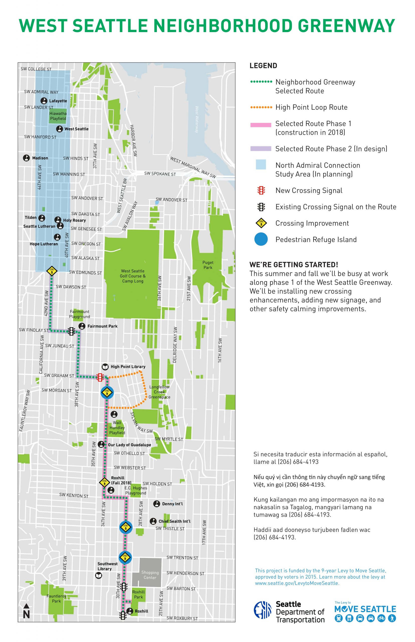
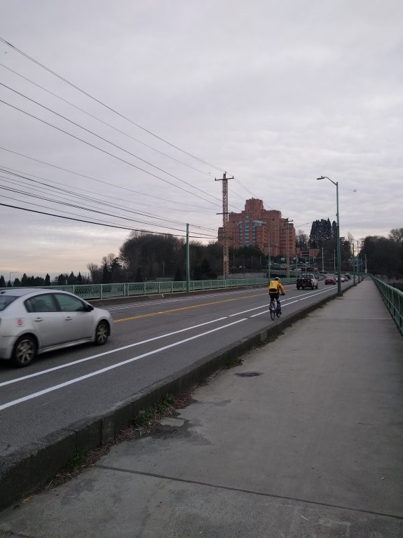
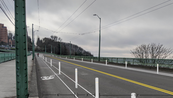
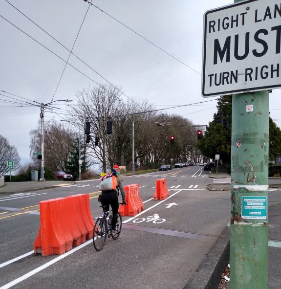
    The plan to finally connect the Duwamish Trail by installing a protected bike lane along the west side of West Marginal Way SW continues to face an uncertain future, as SDOT continues to conduct outreach before a final decision is expected later this Spring.

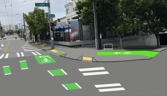
    Last week’s city Freight Advisory Board meeting devoted a considerable amount of time to the topic, after that board had sent a letter to the City in November that asked West Marginal Way “be restored as a five-lane facility”. In order to make that happen, the protected bike lane would have to not be installed, and the 2019 safety improvement that directs traffic into one lane southbound outside the Duwamish Long House would also need to be removed. At the meeting, the SDOT presentation showed exactly why removing that improvement- even after SDOT installs the planned pedestrian crossing signal at the Long House- is a bad idea. The curve in West Marginal at that point creates significant impediments to seeing traffic (often traveling around 40 mph) coming. So far we’ve seen no indication that the City is prepared to listen to the Freight Advisory Board and remove the lane reduction at any point in the future.

    Image showing side by side of sight lines at Alaska Street next to the Duwamish Longhouse, much better with the lane reduction

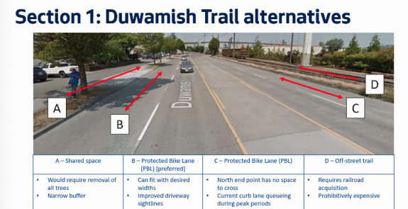
    During that meeting, we also got a look at the different options SDOT studied for extending the trail. The most discussed was Option A, which would have expanded the sidewalk that currently serves as the trail connection. This option would be much more expensive, not be as wide as a normal trail facility, require multiple trees to be removed, and also have sightline issues due to the driveways along the corridor. Option D, in the planter strip next to the railroad tracks on the east side of the street, also would be very expensive and require a new traffic signal to allow people to get back to the west side of the street. That’s true for option C as well, though that would utilize the entire easternmost lane, creating the same issues the freight board is concerned about. Option B, the one SDOT is still proposing, is the best option.

    Google maps view of Marginal with lanes marked with letters on them. West sidewalk A, west curb lane B, east curb lane C, east sidewalk D

    SDOT told the freight advisory board that the Duwamish Trail connection is expected to increase southbound travel times during peak hours by…ten seconds. Yet the board didn’t seem entirely placated by the data provided, with Chair Jeanne Acutanza calling the project an example of “death by a thousand cuts”.

    SDOT's preferred concept of the Duwamish connection, a PBL in the western lane of Marginal Way

    Last Friday, Duwamish Valley Safe Streets, West Seattle Bike Connections, and the West Duwamish Greenbelt Trails Group wrote a joint letter to SDOT Director Sam Zimbabwe expressing their support for the project as the department has designed it. In the letter, they push back on the arguments like those made by Freight Advisory Board members that removing a traffic lane for the protected bike lane would impact traffic on the corridor negatively. From the letter:

    “A significant benefit of the protected bike lane will be to improve traffic safety for all road users by slowing down speeding southbound traffic on West Marginal Way SW. Crashes are frequent and severe. Median speeds were in the mid-40’s and did not come down after speed limits were lowered to 30. Now speed radar signs are up, resulting in only about a 5 mph reduction. There is no congestion problem southbound due to lane capacity. There is a speeding and reckless driving problem, causing crashes and making it treacherous to cross on foot. Traffic congestion only occurs at the south end at the Highland Park Way intersection, where the backup from the First Avenue South Bridge begins. Along most of West Marginal Way SW, frantic drivers are rushing to get into the traffic jam as fast as they can. To hurry up and wait. Making more of the north end consistently one lane will allow drivers who travel at or near the speed limit to control the speed of all traffic, without any effect on throughput across the bridges. The bridges are the choke points, not the street.

    At the West Seattle Bridge Community Taskforce meeting earlier this month, Jolene Haas representing the Duwamish Tribe spoke in favor of the trail connection, saying, “It dovetails into the traffic revisions [at the Long House]…I don’t think it’s going to be a concern, it shouldn’t be.”

    SDOT is planning more outreach in February, including a mailer to West Seattle residents happening around now, as well as an online open house currently scheduled for the middle of next month. It’s a lot of engagement around a traffic lane that SDOT’s data shows is incredibly underutilized right now and providing little public benefit, but our eyes will be peeled for the next chance to speak up in favor of it.

    Calendar timeline stretching from Early January to Late March with decision point in April
    SDOT expects to make a final decision on the Duwamish trail connection by April.
    — Advertisement —
  • Quietly open: the first phase of the Central Ridge Greenway

    City crews are putting the finishing touches this week on a new Neighborhood Greenway on 18th Avenue in the Central District, the first phase in the long-planned Central Ridge Greenway. Along with the normal speed cushions and stop sign adjustments that come with most greenway improvements in Seattle, this corridor now has one of the best arterial diverters in the entire city, at 18th and Jackson Street.

    Map showing 18th Ave between Columbia and Weller Street in orange
    The first phase of the Central Ridge Route.

    The brand-new traffic signal at Jackson prohibits car traffic from continuing across the intersection with plastic barriers and posts, and includes automatic detection for cyclists at the designated waiting area. It also features a nifty light letting you know that you’ve activated the signal, though every time I’ve visited the intersection it’s been activated at all times (which works well also). It’s a clear contender for the best intersection upgrade in Seattle in the past couple of years.

    Right turn only boxes with separate place for a bike in front of diverter in the middle of the intersection
    18th and Jackson includes a really magnificent traffic diverter.

    The intersection of 18th and Yesler also includes brand new bike boxes with signal detection, no button pushing needed on this greenway, which is pretty great.

    Green bike box at intersection with traffic light in distance
    New bike boxes at Yesler and 18th.

    Between Cherry and Jefferson Street, 18th hasn’t gotten any upgrades yet, but a planned expansion of Swedish Hospital to the east will be including streetscape improvements. These unfortunately fall short of making real traffic calming on the greenway, missing a unique opportunity to really create an amazing streetscape that isn’t centered around traffic driving through the block.

    Construction is just ramping up on the hospital expansion so it will be a while before those changes are fully implemented.

    Current view of 18th next to Swedish which is planned for streetscape upgrades.
    Narrower roadway with added greenery and a new five foot sidewalk to access parked cars.
    Planned streetscape changes at Swedish, which do not change much about the dynamics of the block.

    Extending the greenway north to Volunteer Park, in phase 2, has run into funding difficulties. SDOT now says that they do not have enough funds to construct the entire project, and have asked the Move Seattle levy oversight committee for permission to divert that funding to the Stay Healthy Streets program. The pedestrian and the bike advisory boards voted against that earlier this month. That doesn’t mean nothing is planned north of Columbia.

    The Madison RapidRide project will be installing a new signal across Madison Street at 18th Ave, one of the highest-stress points on the current route. Currently there are no markings whatsoever across the expanse of Madison here, and sightlines aren’t great. Adding a new crossing here will be the biggest improvement that would come with the next phase of the greenway. The intersection with Union Street is also getting improvements as part of the planned protected bike lane later this year.

    Crosswalks and sidewalk improvements planned for Madison and 18th
    Upgrade to Madison and 18th planned with the RapidRide project.

    18th Ave north of Columbia already has some existing greenway elements, including chicanes installed in previous decades. And a Neighborhood Street Fund project a few years ago added curb extensions and a marked crosswalk to the intersection with Thomas Street.

    Bulbout in middle of street with yellow and black warning signs
    Chicane on 18th Ave south of Union St.

    Last year, SDOT constructed a Neighborhood Greenway that mostly uses E Republican Street to connect Meany Elementary School and Lowell Elementary School as a Safe Routes to Schools project.

    Map showing greenway connecting Lowell Elementary and Meany Middle School
    A greenway on E Republican Street was installed in 2020.

    We could be getting creative about completing the Central Ridge’s route to Volunteer Park. If the greenway was routed onto 14th Ave rather than 16th, using the Republican greenway, the project could take advantage of a Your Voice Your Choice project that is already adding flashing crossing beacons at the arterial crossing of Aloha Street.

    Ultimately though, the upgrades that are still planned for this route will make the biggest difference, turning what was already a pretty popular route into a better connection to the King Street greenway and now the bike lanes across the Jose Rizal bridge to Beacon Hill.

    — Advertisement —
  • Latest segment of 7th Ave bike lane opens in Denny Triangle

    One way protected bike lane with Amazon campus in background

    The latest block of sidewalk-level one way protected bike lane has opened on 7th Ave in the Denny Triangle, which means that bike lane now runs southbound all the way from Bell Street to Pike Street downtown. There’s also a northbound bike lane, running between Bell Street and Westlake Avenue, which has been open since the end of 2019.

    This is the final block of bike lanes added in conjunction with new buildings in Amazon’s Denny Triangle campus expansion, most of which were installed as part of a public benefits agreement reached over permission to permanently develop the public alleyways on those same blocks.

    The Amazon buildings in Denny Triangle that provided the sidewalk level PBLs

    But it’s not the final sidewalk-level PBL planned for 7th. Another building being developed by Onni north of Bell Street will also include a southbound bike lane. When that’s complete in a few years nearly the entire route between Denny Way and Pike will be grade-separated.

    Rendering of the planned Onni development between Bell and Battery which will complete the 7th Ave southbound PBL

    As for that northbound segment, it’s a bit disjointed. 8th Avenue is the northbound route that connects with downtown, but there are numerous places north of Westlake where it loses any protection from traffic and where drivers can enter and exit the bike lane to use the parking lane. But there’s no easy way to transfer from 8th at Westlake to the 7th Ave sidewalk level PBL. Riding on the sidewalk isn’t really an option. And so the protected facility remains a block away from where it needs to be.

    Bike lane with armored truck in it, and parking next
    The protected bike lane on 8th Avenue stops being protected north of Westlake.

    There are definitely strong feelings around the sidewalk-level bike lanes on 7th, which happened to open just as Amazon was trying out its Amazon Go convenience store concept, generating a lot of foot traffic that ended up spilling into the bike lane. While foot traffic has obviously decreased in the past year or so with most of the Amazon campus quiet, the design of the bike lane absolutely encourages slower travel than a street level lane, and doesn’t really encourage side-by-side riding.

    Perhaps the best aspect of these bike lanes is that they have allowed the city to expand the all-ages network without using much direct city money. As more people begin to return to work downtown in 2021, having these in place will make a lot of people’s downtown trips more enjoyable.

    One way bike lane and lean rails next to the Amazon spheres

    — Advertisement —
  • West Seattle Greenway to bridge 35th and connect to the Junction this year

    This month SDOT says they are starting work on an extension of the West Seattle Neighborhood Greenway, which will finally connect the current greenway in the south end of the neighborhood with Alaska Junction. Most notably, the project will bring a major redesign to one of the area’s most problematic intersections, 35th Ave SW and SW Graham Street.

    Map of the ultimate West Seattle Greenway, with the 2021 portion colored in green (click to enlarge).

    Several high profile traffic deaths have occurred at the intersection of 35th and Graham. It’s been seven years since James St. Clair was struck and killed while attempting to cross the intersection on foot, and fourteen years since Susanne Scaringi was killed while biking across it. There’s not really any good excuse as to why safety improvements at this spot have taken so long to get constructed.

    This project was most recently slated to go in last year, but was delayed due to “administrative challenges, most notably waiting longer than anticipated to receive the final approval for grant funding”. I asked SDOT spokesperson Ethan Bergerson if the new signal here would be a priority due to past issues here, and he told me, “We haven’t determined the construction schedule or order in which improvements will be installed. Safety will definitely be one of the factors which we consider.”

    Currently 35th and Graham is a huge intersection to get across.

    The planned upgrade to 35th/Graham includes a signal for traffic on 35th, marked crosswalks and a green crossbike for traffic on Graham, and traffic restrictions that essentially amount to a diverter- drivers will not be able to go straight across the intersection on Graham Street, and a left turn from 35th will only be allowed onto eastbound Graham, not westbound.

    Plans for the greenway crossing at 35th and Graham include a new signal and diverter.

    The entire extension of the Greenway will be installed on SW Graham Street, 38th Ave SW, SW Findlay Street, and 42nd Ave SW where it will terminate at SW Edmunds Street. The route only includes one other signalized crossing, at Findlay and 39th. At Edmunds, the existing four-way stop will be upgraded with new marked crosswalks.

    42nd and Edmunds will get marked crosswalks.

    The end of the West Seattle greenway is ultimately envisioned in the Admiral District, and SDOT currently has funds to design and plan that extension to the north but not to construct it. Heading through Alaska Junction on 42nd, traffic volumes on the street are higher than they would be on a normal neighborhood greenway, so the street treatments will have to be a bit more robust.

    Designs from 2018 show a few different options to make the Junction segment more welcoming to people on bikes, the tradeoffs between them being parking, so we should expect that discussion to restart.

    Options being considered for 42nd Ave SW in the junction.

    A portion of this existing greenway in High Point is currently functioning as a Stay Healthy Street, with pedestrians and people biking more able to utilize the street space. In the coming weeks we’ll learn if SDOT has selected this route, serving one of the most diverse areas of West Seattle, to be one of the twenty miles of permanent Stay Healthy Streets and to get the permanent traffic diversion improvements that are going to come along with that. Ideally all neighborhood greenways would enable users to feel as comfortable using them as a Stay Healthy street does.

    You can read more about the plans for the 2021 expansion of the West Seattle neighborhood greenway at SDOT’s blog.

    — Advertisement —
  • Jose Rizal bridge bike lane is in place, another harrowing slip lane closed

    The painted bike lane is now in place on the Dr. Jose P Rizal Bridge on 12th Ave S, a big construction milestone in the 12th Ave Vision Zero project, which is creating a bike connection between Little Saigon and the Mountains to Sound Trail at the north end of Beacon Hill. Still to come: plastic delineator posts in the buffer between the bike lane and the other travel lane.

    Still to come: posts.

    With the bike lane comes the vanquishment of one of Seattle’s most treacherous slip lanes, at Golf Drive on the west side of the street. As of this week, it is no more, with drivers directed to make a square right turn at the pedestrian island. This should make everyone not in a car more comfortable at this intersection.

    Bike rider in a lane with three large orange barriers protecting the bike lane that used to be a slip lane
    Golf drive slip lane no more!

    The biggest thing left to complete is work at north end of the PBL, at King Street. The curbs are being rebuilt at two of the corners right now to extend them out, at the spots where people biking would wait for the light to change across 12th, providing a protected spot at sidewalk level to wait for the light.

    The protection for people riding bikes at the intersection of 12th and King.

    The left turn lane from northbound 12th onto King Street toward downtown is being eliminated, with the turn lane and a protected turn phase being moved one block north to Weller St- that one’s already in place. That gets rid of a dangerous turn movement at the connection between protected bike lane on 12th and “neighborhood greenway” on King St.

    Plans for S King Street and 12th Ave S.

    As of now, there are no plans to extend the bike lane any further north than King Street, despite the high number of people biking who use that route.

    Expect to see work being done in the coming weeks to add the plastic posts, and finish the work in Little Saigon, but the lane is open, and it’s currently getting a lot of use as people biking who previously had to contend with impatient drivers on the bridge now have their own space.

    Later this year we’ll get more details on the next phase of this protected connection, the Beacon Hill bike route planned for construction in 2023.

    — Advertisement —
  • WA House Democrats propose transportation package with huge multimodal component

    Rep. Jake Fey, chair of the House Transportation Committee

    Correction: a previous version of this post listed the timeframe of this package at 12 years instead of 16.

    Yesterday the Democratic caucus in the Washington State House announced their proposal for the next major state transportation package. Their proposal would raise over $26 billion dollars over a sixteen-year period and include a brand-new carbon fee, the proceeds of which would be directed to a host of “carbon reduction initiatives”, including unprecedented state spending on multimodal transportation.

    The proposed spending includes:

    • $267 million for direct bike & pedestrian projects
    • $318 million for bike & pedestrian grants to local governments
    • $290 million for Safe Routes to School grants
    • $59 million in Complete Streets grants
    • $333 million in transit grants
    • $800 million in bus & bus facility grants
    • $960 million in special needs transit grants
    • $240 million in rural mobility transit grants
    • $200 million in green transit grants
    • $80 million in tribal transit grants

    That works out to over $80 million for every 2-year state budget in active transportation grants alone distributed to counties and cities statewide, to say nothing of the grants for public transit. This would amount to a big shift in transportation spending away from being primarily focused on highways and ferries alone.

    The direct investments at the state level in bike & pedestrian projects should hopefully take some of the recommendations of the state’s Active Transportation plan and put them into action. You can read a full breakdown of the known spend plan here.

    At the same time that a progressive carbon tax is proposed to fund projects that will decarbonize and electrify transportation, the package also proposes a black box of $6.7 billion in new “state & local projects”. These are likely new highway projects, but the only project we know about for certain right now is the proposed replacement of the I-5 bridge between Washington and Oregon, which would receive $1 billion. The total $3.2 billion price tag for that project is so high in part because of the amount of added capacity that is likely to come with it. The rest of the projects in the black box are expected to be negotiated via the legislative process later this session.

    The proposal would also direct a much higher amount of money toward preserving and maintaining current transportation infrastructure than we’ve seen in recent years, with $4.6 spent to reduce the maintenance deficit over 16 years. It would also spend $3.5 billion to fully remove fish culverts statewide in compliance with a court order.

    The funding for highway expansion and maintenance would be funded by a gas tax increase, bringing Washington up to 85 cents per gallon, the highest in the country. The proposal would also index the gas tax to the consumer price index, allowing it to better keep up with inflation.

    This transportation package takes Senator Rebecca Saldaña’s proposed package from the State Senate side, which would make $2 billion in multimodal investments over twelve years, and takes it to the next level. But it may run into opposition from other Democrats in the Senate who want to see a transportation package focused even more around highway expansion. But this is clearly the new bar for a progressive transportation package, at least on the House side- one that recognizes we need to massively scale up our multimodal investments. In the coming weeks we’ll see how much traction the proposal is able to gain.

    — Advertisement —
— Advertisement —

Join the Seattle Bike Blog Supporters

As a supporter, you help power independent bike news in the Seattle area. Please consider supporting the site financially starting at $5 per month:

Latest stories

— Advertisements —

Latest on Mastodon

Loading Mastodon feed…