Representative Sharon Shewmake, 42nd Legislative District
A bill introduced into the Washington House of Representatives by Representative Sharon Shewmake (D-Bellingham) would exempt electric bikes, and up to $200 in bike accessories, from state sales taxes. HB 1330 would not apply to non-electric bikes, using the definition of ebike in state law, “bicycle with two or three wheels, a saddle, fully operative pedals for human propulsion, and an electric motor. The electric-assisted bicycle’s electric motor must have a power output of no more than seven hundred fifty watts”.
On Twitter, Rep. Shewmake explained her reasoning for confining the legislation to ebikes:
“My thinking was e-bikes are emerging tech and a car replacement. Haul kids, handle hills, more groceries! We give tax breaks to EVs but not e-bikes which are cheaper, don’t take up as much space, use less electricity, are FUN and a LOT cheaper but still suffer from sticker shock.”
As written, the exemption would take effect on August 1st of this year, and expire in 2027 or if $500,000 in sales taxes have been waived under the provision, whichever comes first. However, there’s also a provision that signals the intent of the legislature to extend the exemption if it’s successful, specifically if sales of ebikes go up 25% or more compared to 2020 levels.
Bike accessories that qualify for the exemption (up to $200) are defined as “cycling accessories commonly associated with bicycle ownership including, but not limited to, helmets, bicycle locks, fenders, lights, and a bicycle service or repair plan, purchased as part of the same transaction as an electric bicycle”.
This bill would be an easier pathway to providing a state-supported boost to ebike ownership than a frequently-discussed rebate program (which we should also be pursuing). The transportation package floated during the 2020 session actually included a special sales tax on bikes, which would match a similar fee passed in Oregon in 2017, but so far we’ve seen no indication that a transportation package in either legislative house will include a special bike tax.
To stand a chance getting through the legislature, the bill currently needs co-sponsors. Contact your local House members to ask them to add their name to HB 1330.
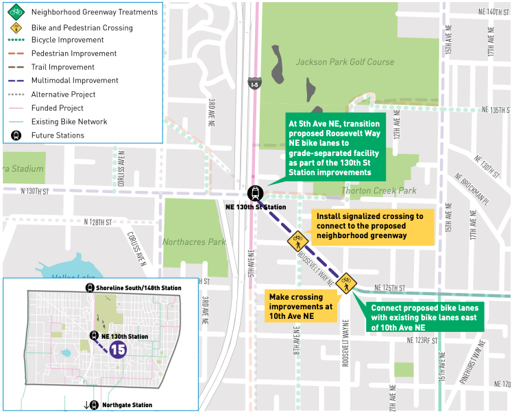
SDOT has released a study looking at how to improve access for people walking and biking around two coming light rail stations at the north end of the city. The station in Shoreline at 148th Street is currently planned to open with the Lynnwood Link extension in 2024, and the planned infill station at 130th Street was originally scheduled for 2031, but this year the Sound Transit board will be voting on whether to move that up to 2024 so that they open at the same time.
This is the result of community engagement since 2019 being headed up by Seattle’s Office of Planning and Community Development, in conjunction with land use changes in the surrounding neighborhoods.
The study includes a current map of “level of traffic stress” for people biking around the vicinity of both stations. It has a lot of red, including a segment of pretty much every east-west route someone would use to access either station. The only separated bike facilities are the Interurban trail, pretty far away from the I-5 corridor where the train stations are, and a loosely protected bike lane on Pinehurst Way. The red on the map underscores the fact that there isn’t much of a bike network, and that we have a lot of work to do.
“Level of traffic stress” map for the area around these two light rail stations. (Click to enlarge)
This gets ahead of the planning for station access at these stations, but the projects “will still need to compete for transportation funding resources” from sources like the next transportation levy (starting in 2025, if it passes) or Sound Transit’s station access fund. The study also says “we encourage the community to pursue other available funding sources identified in the City of Seattle’s Community Resource Guide”, aka finding your own funding sources to improve access to light rail stations.
All of these projects will be built on top of the improvements coming directly at the stations themselves. NE 130th Street station is currently planned to have a ten foot “shared use path” directly outside the station running along 5th Ave NE between 130th and 145th Street. This will be the only pedestrian access between these two streets except for the pedestrian trail that exists on the edge of Jackson Park golf course, which is not fully accessible. The I-5 side of 5th Ave NE will not have sidewalks; riders who get off the trail will meet a dead-end at the north end of the station exit.
Planned “shared use path” on 5th Ave NE in front of 130th Street Station
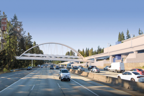
Shoreline is currently planning to build a pedestrian and bicycle only bridge across I-5 to connect with the station at NE 148th Street. That bridge will connect via trail with 1st Ave NE but it doesn’t look like there will be any bike facilities on that street, with riders directed to the “off-corridor bike network” in Shoreline, aka neighborhood greenways. 5th Ave NE directly outside the Shoreline station also won’t have any bike facilities, according to the most recent plans.
Planned bike & pedestrian bridge across I-5 at NE 148th Street in Shoreline
As for the study itself, the projects that were ranked highest in the study are likeliest to be prioritized, tier 1 projects were defined as “provid[ing] direct access to the future stations; the rest of the network builds on these projects.” In other words, if these projects aren’t complete or in progress by the time the station opens, we will have missed a big opportunity.
So what are the highest-ranked projects in the study?
Improve the I-5 crossing at 130th Street with a shared use path
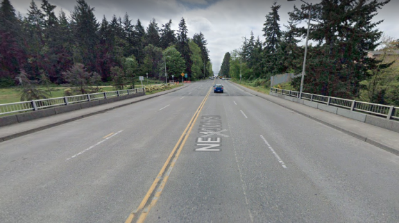
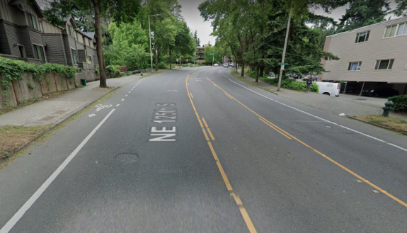
Current state of N 130th Street
Unsurprisingly, one of the top improvements here is to remake the bridge over I-5 at 130th Street which is currently four travel lanes and fairly narrow sidewalks. The recommended treatment here is a shared use path on the north side of the street (the light rail station will be completely on the north side).
A shared use path is proposed for the north side of NE 130th Street. (Click to enlarge)
Extending the shared-use path all the way to Aurora Ave is looked at as a separate project, but a neighborhood greenway on N 128th Street is also cited as an alternative. “This option would reduce conflicts between transit and bikes on N 130th St” is perhaps the wrong way to think about that.
145th improvements
145th Street is a state highway between Aurora Ave and Lake City Way, SR-523. Shoreline is taking the lead on street improvements on the corridor, with the latest proposal adding two roundabouts to the intersections on either side of I-5 at 145th, 1st and 5th Ave. The only bike facility currently proposed for the corridor would be a short stretch of shared-use path on the north side of the bridge over the interstate.
Current early plans for I-5 at 145th Street. (Click to enlarge)
The top rated projects on the Seattle side for 145th are almost entirely all crossing improvements. Improvements to the sidewalk adjacent to Jackson Park golf course were also included- there the sidewalk is frequently encroached on by vegetation and utility poles, and it’s just an unpleasant place to walk. That sidewalk is the only way to complete a full loop around the golf course.
Jackson Park trail improvements
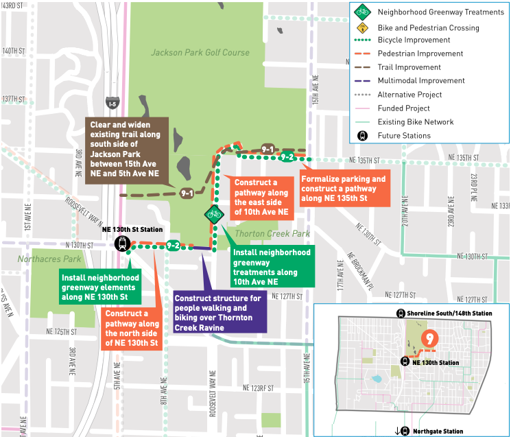
On the southern end of Jackson Park golf course, the trail cutting east to west will be a frequently used pathway for people accessing the light rail station at 130th, with or without improvements to it. The most likely improvements are to widen the existing trail that connects with 5th Ave NE. But SDOT is also considering reclaiming right-of-way that doesn’t currently exist along 10th Ave NE to create a connection between Jackson Park and 130th Street. This could include neighborhood greenway elements and separated pedestrian facilities.
A number of projects could improve access to 130th Street Station via the Jackson Park trail. (Click to enlarge)
NE 125th Street and Roosevelt Way redesign
Roosevelt Way NE is a diagonal street connecting directly between 125th and 130th Street at the proposed light rail station. 125th currently has paint bike lanes, but they disappear at Roosevelt Way (as well as in the other direction before Lake City Way).
NE 125th Street currently has painted bike lanes only.
This project would install protected bike lanes between 125th and 130th, and take the number of general purpose lanes on Roosevelt down from four to three. This would really improve bike access between the station and the heart of Lake City.
Protected bike lanes could be added to Roosevelt Way NE. (Click to enlarge)
Seattle is really good at creating plans, and there’s a lot of great ideas in this study for making it easier to get around the vicinity of these light rail stations, at least one of which is opening in just a few years. Identifying funding sources is pretty important to getting these actually built, but it’s likely there will be a lot of competition for those pots of money when they become available. Most of these projects are pretty essential in getting the most out of the billion-dollar light rail investments that our region is making, and we should treat them that way.
You can read the entire Station Access Study which includes many more proposed projects at SDOT’s blog.
As of this past Monday morning, SDOT has turned on the automatic cameras that are able to ticket drivers $75 who aren’t authorized to use the Spokane Street drawbridge between 5 am and 9pm. This is great news for transit riders who cross the bridge and other essential workers allowed to use it. That day also marked seven months since the law the state legislature authorized allowing automatic enforcement of restricted lanes went into effect, and over nine months since it was signed by the Governor.
The pilot program also allows Seattle to issue automatic tickets to drivers who block an intersection or a crosswalk at up to twenty locations “where the Seattle Department of Transportation would most like to address safety concerns”, per the ordinance that the city council passed last year. But the city can only pilot those cameras until June 30 2023, meaning less than 30 months remain in the pilot, and we still don’t know what that list of camera locations is going to be.
Mercer and 9th Ave N is a busy bike corridor that is frequently impacted by drivers blocking the box.
SDOT spokesperson Ethan Bergerson told me that the agency hasn’t determined a list of camera locations yet, nor was he able to provide an estimate of when any crosswalk enforcing camera locations might be announced.
When the law authorizing a pilot program was before the legislature, a large portion of the contingent that showed up to support it was pushing for that crosswalk enforcement element, to improve safety for everyone and improve mobility for people with disabilities for whom blocked crosswalks often mean harrowing detours. Without those voices working together with transit advocates pushing for the tools to enforce bus-only lanes, it’s likely there would be no pilot program at all.
The legislature had been considering an automatic camera bill with a crosswalk component since January of 2019, with a transit lane bill also before the legislature in the 2018 session and discussed by legislators well before that. It is surprising that a list of locations was not ready to go.
The pilot program requires a report to be delivered to the legislature by June 30 of next year. Assuming a few months of process and outreach for a brand new type of enforcement camera, it’s possible that the initial report may barely include a year of data on crosswalk enforcement. The renewal of this program, or its being made permanent, would be one necessary step in reducing the role of in-person traffic enforcement. Without making this change permanent, Seattle can only enforce red lights, railroad crossings, and speeding outside schools during specific times with automated cameras. But first, the pilot program needs to be successful. For that to happen, it needs to begin.
The Washington State House of Representatives Transportation Committee convened for the first time this session on Tuesday and WSDOT head Roger Millar was there to lead the members through a presentation, which was titled “Return on Investment”.
At the beginning of the talk, he made sure to emphasize that the legislature calls the shots and selects the projects, not WSDOT. But the framing of the presentation was focused on what kinds of investments might produce a higher return for the state as a whole. And he showed the committee a slide that broke down different categories where those costs are currently playing out.
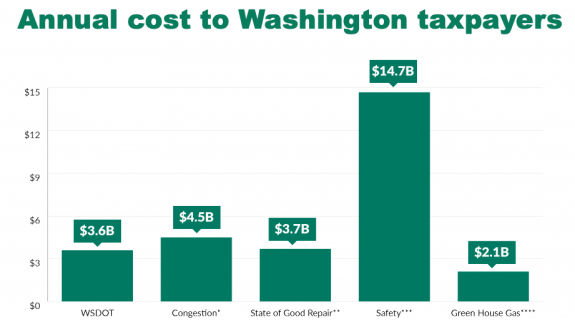
Safety was the biggest impact shown. The annual cost of traffic crashes that happen because our transportation system isn’t safe enough was pegged in his data at $14.7 billion per year, which is over four times the actual budget of WSDOT itself. And it’s over 3.2 times as much as the cost attributed to “congestion” which the legislature seems much more preoccupied with.
Safety impacts cost Washingtonians $14.7 billion per year compared to the $3.6 billion WSDOT budget
“If we could drive these numbers down by increasing what we spend on transportation, we could have that increased investment and actually save hardworking families and hardworking businesses some money on the way”, he told the committee members. Of course, we could save much more than money by improving safety in the transportation system, we could save lives and prevent devastating life-altering injuries. It’s actually absurd to put this side-by-side with a so-called cost to sitting in traffic, but given the legislature’s track record clearly necessary.
What Millar did not do is directly connect the dots on safety, but his agency is doing that right now, in part with the Active Transportation Plan. Spending $283 million on adding speed treatments to every single state highway through a population center would save lives. So would spending $165 million to improve safety at every single highway ramp in the state. Or $1.2 billion to add full pedestrian facilities along state highways.
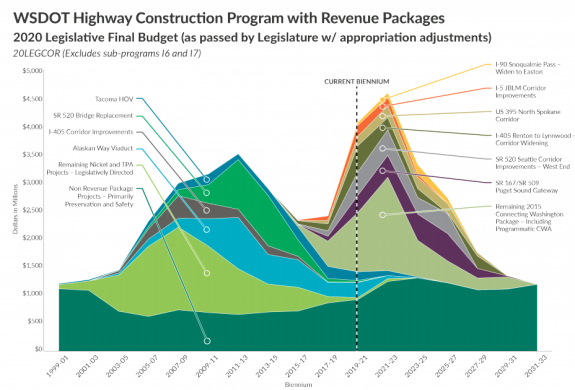
Millar’s speech to the committee comes at a time when, according to slides in his presentation, Washington is set to spend more money maintaining and expanding the state highway than it ever has before. This was conveyed in a chart showing highway construction heading toward a peak of nearly $5 billion in the next biennium as so many different highway expansion projects are set to be under construction at the same time.
Washington is set to spend the most on highways, ever.
Secretary Millar also tried to make the argument against highway expansion from the perspective of jobs creation, citing numbers showing that bicycle projects create 46% more jobs per million dollars spent than car-only road projects, and that public transit projects create 31% more jobs.
Clearly leadership at the state’s transportation agency wants to take the state in the right direction but, again, they don’t choose the projects to build. Roger Millar’s presentation this week should set the stage for making smarter investments than we have made in the past, with Senator Saldaña’s Evergreen Package an obvious vehicle for that, but only if we are ready to push against the status quo.
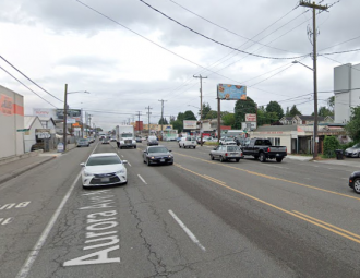
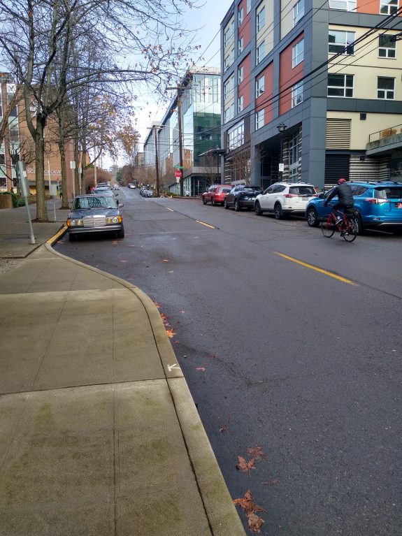
Aurora Ave N near the location where 92% of drivers were recorded going over the speed limit
A speed study conducted by the Seattle Department of Transportation early last October showed that 92% of drivers using Aurora Ave N at N 112th Street, where the speed limit is 35 mph, were exceeding that speed limit, with 66% of drivers going 5 mph or more over the limit and more than one in four drivers exceeding the speed limit by 10 mph or more.
Another speed study conducted last August further south at N 68th Street, just south of a zone with a 30 mph speed limit, showed slightly lower speeds despite a speed limit of 40 mph at that spot. There 19% of drivers were clocked at going over 45 mph with 26% of drivers recorded at that speed up at 112th.
Most of Aurora Ave N has a speed limit of 40 mph, with segments signed for 30 and 35 mph in the most dense commercial areas along the state highway. In late 2019, Mayor Durkan announced that nearly every single arterial in the city would have its speed limit lowered to 25 mph, but a state highway like Aurora Ave requires the city to coordinate any speed limit changes with the state and so far we haven’t heard any indication it will be moving to lower speed limits here.
As the speed studies show, simply lowering the speed limit will likely not do much to influence driver speed; more comprehensive design changes will be required. But the problem is urgent: in the past two-years, ten people have died on Aurora Avenue in Seattle, most of them people walking along the street. Statistically, a pedestrian struck by a vehicle traveling 40 mph has a one in ten chance of surviving the crash.
SDOT Director Sam Zimbabwe responded early this morning after several North Seattle state legislators in recent weeks indicated support for changes to improve safety on Aurora but pointed toward a need for SDOT to take the lead on those changes. He was responding to Lee Bruch, an outspoken advocate for a safer Aurora Ave. His response:
“It is great to hear about the State-level support for continued investment in Aurora. We continue to work on small-scale changes to address the most challenging locations, but there is a limit to what results those can bear. Some planning and project definition work is really the next step for us on those larger investments, which is reflected in that grant you cite below. We face major investment needs in safety and infrastructure across the city and will need partnerships at all levels to bring those to fruition with the urgency needed. The planning work will better define what comes next while we continue to work on smaller steps to improve safety for all users.”
The City has applied for a state grant that would fund most of a $2 million study to determine changes to the street. It is frustrating to have to wait for a new study to be able to implement design changes to lower speeds on a street that has had the same problems for decades, but if that’s what’s necessary to ensure that the changes are comprehensive, so be it. Aurora Ave was just repaved for its entire length, which would have been a perfect chance to implement changes, but not even sidewalks could be added where they are currently missing.
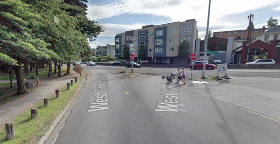
Bruch told me today he was positive about Director Zimbabwe’s response: “I agree with him on the necessity to do long range planning”, but told me there were a lot of spot improvements that could be made along the corridor. One of those is a possible expanded sidewalk protected bike a jersey barrier near Green Lake where a UW student was struck by a car in 2019. He also pointed toward the closure of the slip lane off Aurora onto West Green Lake Drive as an example of where obvious improvements could be made.
Slip lane at West Green Lake Drive and Aurora Ave N
Ultimately, Aurora Avenue needs to be redesigned for lower speeds along its entire length. While it’s true the city faces a lot of need for safety improvements as Director Zimbabwe indicates, Aurora Ave sees a huge proportion of the injuries and fatalities on Seattle’s streets, and to date it doesn’t seem like the City is treating it that way.
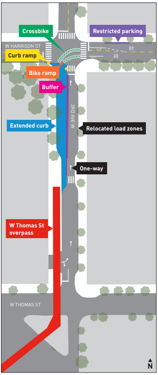
Today we are circling back to some news that we missed from last autumn. SDOT has announced they will be making big upgrades to the Queen Anne approach of the Thomas Street overpass connection to Myrtle Edwards Park and the Elliott Bay Trail this year. This improvement comes as part of the package of transportation changes planned with the opening of Climate Pledge Arena this fall.
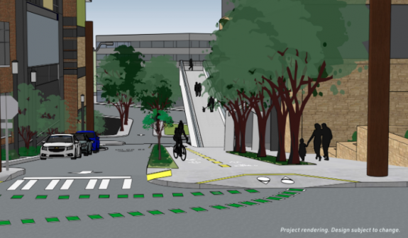
After public comments supported the option allocating the most space for walking and biking here, SDOT will convert the entire western half of 3rd Ave W north of the overpass to an extension of the trail, with delineated space for two directions of bike travel created out of one half of the current street, turning the street into a one-way for vehicle traffic northbound. This is how the street basically operates now anyway, with most traffic going west on Harrison instead of south on 3rd to access Elliott Ave.
SDOT’s rendering of 3rd Ave W looking toward the overpass.The southbound side of the street will be entirely converted to walking and biking space.
This will alleviate a big pinch point to a great connection- currently people biking over from the waterfront get to decide between biking on a sidewalk that’s not in great condition or taking the lane on 3rd Ave W, where drivers heading off of Elliott Ave frequently exceed the speed limit.
Bird’s eye view of the planned improvements.
SDOT also announced they will be installing a protected bike lane on W Harrison Street which will connect to the planned two-way PBL on Queen Anne Avenue N, but only in the uphill eastbound direction. People biking westbound will be in a travel lane that SDOT will be adding speed cushions to. SDOT is also adding four new all-way stops in the area which should slow traffic as well.
Map showing the planned connections between the Thomas Street overpass and the Seattle Center bike facilities.
SDOT had originally envisioned bike traffic using either Thomas or Republican Street to connect to the overpass, but Harrison makes much more sense given the street grades in the neighborhood.
The overpass connection is one spoke of the bike network improvements coming with the arena, the other main one being a connection with the 2nd Avenue protected bike lane via 1st Ave and Broad Street. Thomas Street on the other side of the Seattle Center was another improvement, but that has been put on hold. As for the disappointing news about the Denny Way terminus of the 2nd Ave PBL, we will be bringing you additional info about that soon.
On the other side of Myrtle Edwards, any bike connection between the Elliott Bay Trail and the planned waterfront bike trail remains unfunded as the rest of the waterfront’s reconfiguration moves forward.
But the Thomas Street overpass spot improvements and the connecting one-way PBL are definitely something to look forward to this year.