— Advertisement —
  • Lime launches scooter share in Seattle

    Screenshot from the Lime app showing a scooter available.After years of talking, the first shared electric scooters are hitting Seattle streets today as Lime rolls out 500 of its popular Lime-S scooters.

    Lime has been serving Seattle for years with its pedal bikes and e-bikes. The company now owns and operates the red JUMP bikes available around town. Though the city has invited three companies to operate scooters in town, Lime was clearly in the best position to launch quickly.

    “As Seattleites look to open-air transportation options that allow for social-distancing, shared scooters offer a reliable solution for short and medium-length trips, as well as for trips not served by public transit,” the company said in a press release. “The Seattle e-scooter pilot will help reduce car usage, augment transit and allow for safer and more sustainable travel.”

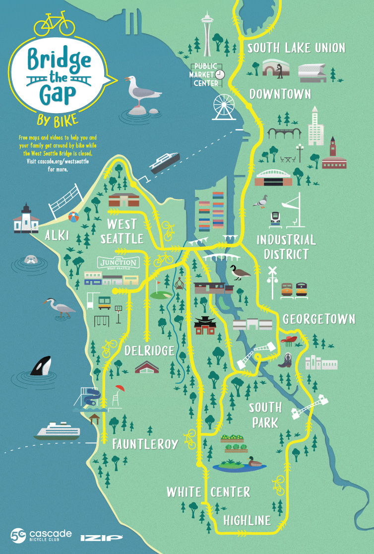
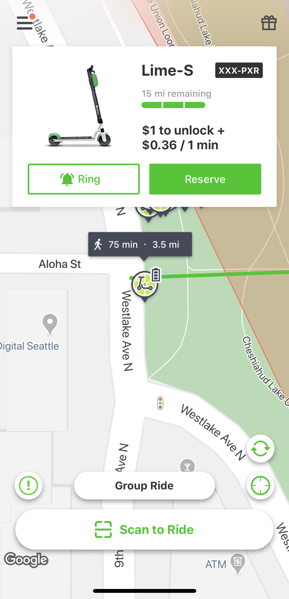
    Their scooters cost the same as the JUMP bikes, with a $1 fee to unlock plus 36¢ per minute. While they are limited to only 500 scooters, the company is limiting their distribution efforts “from the Central District and SODO to Capitol Hill, Downtown, South Lake Union, Ballard, Fremont and the U District,” but users are able to ride them anywhere in the city that they want. Notably, this initial distribution area does not include West Seattle, though people can ride to West Seattle if they want to. Helping with the West Seattle Bridge transportation crisis was one reason the city cited during City Council debate over the permit plan. “As the fleet is authorized to expand, the deployment areas will expand,” the company noted in a press release. (more…)

    — Advertisement —
  • Cascade launches flashy new resource to help people bike to and through West Seattle

    Illustrated map showing common West Seattle bike routes.Cascade Bicycle Club and IZIP electric bikes partnered to create a pretty great-looking map of popular bike routes to and through West Seattle to help more people visualize how they can shift more trips to bike.

    The illustrated map is cool because it’s a high-level look at the options. But once someone is interested in the details of each route, Cascade has very detailed guides online. For two routes (Junction to downtown and White Center to downtown), they have Ride With GPS maps (which can be used for turn-by-turn directions) and very good video guides.

    Screenshot of the video thumbnails and maps from the Cascade website.
    Screenshot from the Cascade website.

    (more…)

    — Advertisement —
  • Bike Route Alert: Lynnwood Link construction will close Scriber Creek Trail for 2 years, disrupt Interurban Trail

    Map of the planned closures and detours near Lynnwood Park and Ride.Work on Lynnwood Link will close the Scribner Creek Trail for two years and will require intermittent closures of the Interurban Trail, Sound Transit says.

    The Scribner Creek Trail is basically a path along the southwest edge of the Lynnwood Park and Ride parking lot that connects to the Interurban Trail. So if you don’t recognize the name, you may use this trail if you access the trail from the park and ride.

    The more significant impact, though, will be the series of Interurban Trail closures in the area over the years of construction. The first such closure is scheduled for late October and will last two weeks, but later closures could last up to 6 months. And the detour route includes a busy stretch of 200th Street SW and the sidewalk of 44th Ave W (there is no curb cut from 44th to the trail, so the sidewalk is the only option unless Sound Transit adds a ramp). Maybe there will be an unofficial way to weave through the park and ride area to skip some of the detour, but the official detour map doesn’t suggest an alternative.

    Details from Sound Transit: (more…)

    — Advertisement —
  • Seattle knew 5 years ago that a Rainier Ave safety project would save lives, but is just now starting work

    Diagram of the new road layout with bus lanes and a center turn lane.Rainier Ave S has long held a terrible title: The most dangerous street in Seattle. It saw more crashes per mile than the city’s other deadly streets, including Lake City Way and Aurora, despite carrying far fewer trips.

    “During a 6-month study in 2015, on average, there was 1 crash per day that took 45 minutes to clear,” SDOT wrote on the project website.

    Despite being the central commercial street for many Rainier Valley neighborhoods, Rainier Ave was designed like a highway. With multiple lanes in each direction and no center turn lane, the street encouraged speeding and prioritized people traveling through the neighborhood over people trying to make turns or cross the street. So not only were there a lot of crashes at high speeds, but they were often the most dangerous kind (pedestrian, cyclist, head on and left turn collisions). The result has been decades of people dying and being seriously injured with little to no action to prevent them.

    Then in 2015, Seattle redesigned a stretch of Rainier Ave S in Columbia City to reduce collisions along one part the street. It took an enormous amount of political pressure, including a protest in Columbia City, to convince the city to take action and redesign the street. And the results were jaw-dropping. Just by repainting the lines and changing some signs, SDOT’s Vision Zero team was able to reduce dangerous collisions and speeding by huge percentages. But most notably, this stretch of the street averaged 9 serious injuries and 1 death every year before the changes. The project reduced that to zero.

    Chart showing before and after collision counts on Rainier Ave following a 2016 safety project.With such an incredible success, the city immediately went out and completed this safety project along the rest of the street, right? The logical and compassionate response to the results in these charts would be to all but declare a public health crisis and fix the rest of the street immediately before more people get hurt. If this were a medical study, researchers would have taken one look at these results, stopped the study and then immediately administered this obviously effective medicine to all patients. Because physicians have a sworn ethical duty to do no harm, and every number in these charts represents a real human being with people who love them. Even one should be considered unacceptable.

    But there is no Hippocratic Oath for people making transportation policy. It is considered acceptable to knowingly allow people to die preventable deaths in traffic, and therefore such deaths are not treated like an emergency. (more…)

    — Advertisement —
  • SDOT: Keep Moving Streets extended until October 5

    Chart showing increased bike use on Lake Washington Blvd during the Keep Moving Street program.
    From SDOT.

    Seattle’s car-light Keep Moving Streets have been a success, so the city has extended them another month.

    Created in partnership between SDOT and Seattle Parks, the city’s four Keep Moving Streets are typically on arterial streets near parks or along waterways that don’t have enough sidewalk space to safety handle all the people who want to use them. Streets, on the other hand, have lots of space. So the city decided to try closing streets to through traffic (local access is allowed) and open that space to walking and biking.

    And people love it.

    The program has been extended until October 5. But there’s no reason to think they won’t be needed beyond that point. Neighbors of the Alki Point project even put together a campaign to make it permanent (complete with a video).

    More details on the October extension from SDOT: (more…)

    — Advertisement —
  • Bike Route Alert 9/11-14: 520 Bridge closed, including the trail

    Map of the 520 Bridge closures.The 520 Bridge will be closed 11 p.m. September 11 until 5 a.m. September 14 for a series of major construction projects. These closures include the trail over the lake.

    The trail under the bridge on the Montlake side connecting Shelby/Hamlin to Lake Washington Blvd will be open during the daytime, but will close at night.

    Details from WSDOT:

    Reminder to travelers: SR 520 will completely close for construction between Seattle and the Eastside from 11 p.m. Friday, Sept. 11, to 5 a.m. Monday, Sept. 14. During that weekend, crews will repair a damaged sign bridge that goes over all lanes of SR 520, realign Montlake’s eastbound SR 520 on-ramps, restripe a section of the westbound lanes, and more. Check out our latest video to learn more.

    What travelers should expect:

    • All east- and westbound lanes will be closed between Montlake Boulevard and 92nd Avenue Northeast near Medina.
    • The SR 520 Trail will be closed across Lake Washington.
    • The temporary path under SR 520 between East Montlake Park and Lake Washington Boulevard will be open during the daytime, with flaggers present, so please use caution. This path will close at night.
    • SR 520 will remain open between I-5 and Montlake Boulevard.
    — Advertisement —
— Advertisement —

Join the Seattle Bike Blog Supporters

As a supporter, you help power independent bike news in the Seattle area. Please consider supporting the site financially starting at $5 per month:


Latest stories

Bike Events Calendar

Jul
25
Thu
7:15 pm Point83 @ Westlake Park
Point83 @ Westlake Park
Jul 25 @ 7:15 pm
Point83 @ Westlake Park
Meet up in the center of the park at 7ish. Leave at 730. Every Thursday from now until forever rain or shine. Bikes, beers, illegal firepits, nachos, bottlerockets, timetraveling, lollygagging, mechanicals, good times.ShareMastodonTwitterFacebookRedditEmail
Jul
27
Sat
all-day Bicycle Weekends on Lake Washing…
Bicycle Weekends on Lake Washing…
Jul 27 – Jul 28 all-day
Bicycle Weekends on Lake Washington Blvd
Details from Seattle Parks: On scheduled weekends from May to September, a portion of Lake Washington Boulevard will be closed to motorized vehicles from 10 a.m. Saturday to 6 p.m. Sunday. “Seattle Parks and Recreation[…]
1:00 pm Seattle Queer History Ride 2024 … @ Volunteer Park (Black Sun sculpture)
Seattle Queer History Ride 2024 … @ Volunteer Park (Black Sun sculpture)
Jul 27 @ 1:00 pm – 4:30 pm
Seattle Queer History Ride 2024 - Capitol Hill to University District (Leisurely) @ Volunteer Park (Black Sun sculpture) | Seattle | Washington | United States
Join me for a 7 mile bike ride going from Capitol Hill into the University District at a Leisurely pace. We’ll visit various sites relevant to Seattle’s current gayborhood and gathering sites around UW.ShareMastodonTwitterFacebookRedditEmail
Jul
28
Sun
all-day Bicycle Weekends on Lake Washing…
Bicycle Weekends on Lake Washing…
Jul 28 – Jul 29 all-day
Bicycle Weekends on Lake Washington Blvd
Details from Seattle Parks: On scheduled weekends from May to September, a portion of Lake Washington Boulevard will be closed to motorized vehicles from 10 a.m. Saturday to 6 p.m. Sunday. “Seattle Parks and Recreation[…]
Aug
1
Thu
7:15 pm Point83 @ Westlake Park
Point83 @ Westlake Park
Aug 1 @ 7:15 pm
Point83 @ Westlake Park
Meet up in the center of the park at 7ish. Leave at 730. Every Thursday from now until forever rain or shine. Bikes, beers, illegal firepits, nachos, bottlerockets, timetraveling, lollygagging, mechanicals, good times.ShareMastodonTwitterFacebookRedditEmail
— Advertisements —

Latest on Mastodon

Loading Mastodon feed…