— Advertisement —
  • The Climate Cavalry Is Us, Councilmember Pedersen

    Last week, District 4 Councilmember Alex Pedersen’s office sent an email including highlights from his first year in office. It included a section titled “Transportation and Climate Change”. An excerpt:

    Seattle is not about to let up on its efforts to reduce address climate change, which currently include reducing carbon emissions and increasing our resiliency (“adaptation”) in the face of the negative environmental changes already underway. But as Chair of the Council’s Transportation & Utilities Committee, I can tell you it’s a relief that a new federal administration is entering that clearly embraces the science, the national and international efforts required to reverse the global threat, and the environmental and economic benefits of transitioning to a more green economy. This includes President-Elect Biden’s appointment to the U.S. Dept of Transportation, the Dept of Energy, and a new cabinet-level climate advisor. I believe the climate calvary [sic] is coming.

    While reaction to the news of former South Bend Mayor Pete Buttigieg being named Biden’s Secretary of Transportation has been mixed among transportation advocates, there is little doubt that Biden is taking the issue of climate change more seriously than probably any other incoming President in history. There is an unprecedented amount of momentum behind the incoming administration to do climate-related work.

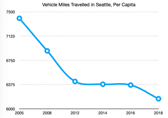
    But with the recent news that Seattle’s overall emissions increased between 2016 and 2018, and  the fact that we are wildly off-course on reducing our transportation emissions compared to the goal passed by the city council in 2013, it’s dangerous for the chair of the transportation committee to be waiting for the federal government to get Seattle on track to reduce emissions. The climate cavalry is here, and it is us.

    Most cities in the US do not have a publicly-owned power utility, much less one that has been carbon-neutral for fifteen years. Few cities have bucked a national trend of declining transit ridership due to decades of disinvestment. Even if you include industrial and air sector emissions, Seattle’s per capita emissions are already less than half of the nationwide per capita total. We have a huge advantage relative to the rest of the country, and we want the cavalry to come help us?

    For the chair of the Transportation & Utilities Committee, it has been a very unusual year to conduct committee business, that’s for sure. But after the outgoing transportation chair, Mike O’Brien, made sure that the committee had a role in shepherding the progress of the modal master plans, this year the committee has spent no time reviewing the updates & impact to project completion from the mayor’s budget cuts. SDOT is far behind on its yearly goal for new sidewalk completion, as just one example, with the schedule to catch back up currently unclear. The 2013 Climate Action Plan, which the Durkan administration has only tacitly embraced, connects all of these existing plans together and recognizes that they further the city’s climate goals, but implementation requires leadership.

    Earlier this year, Councilmember Pedersen chaired the committee to send the renewal of the Seattle Transportation Benefit District back to the voters. The Mayor’s proposal was smaller than the original STBD passed in 2014, due to the exclusion of a car-tab fee while the fate of I-976 was uncertain, which translates to fewer transit service hours being funded. A 50% increase was proposed in committee, from a 0.1% to a 0.15% sales tax, but Pedersen voted no on that amendment. Thankfully it passed anyway, and voters resoundingly said yes. Just last month, with a car-tab fee unlocked after I-976 was ruled unconstitutional, Pedersen teamed up with councilmembers Lewis and Herbold to propose using the money to fund bridge maintenance instead of transit, weeks after SDOT just cut the ribbon on a brand new $100 million bridge in SoDo.

    Seattle scaling back transit investments, on the heels of the wildly successful transit benefit district providing very frequent transit service to 70% of city households in 2019, will absolutely lead to more car trips and increased emissions. The Biden administration can’t save us from making own-goals like that.

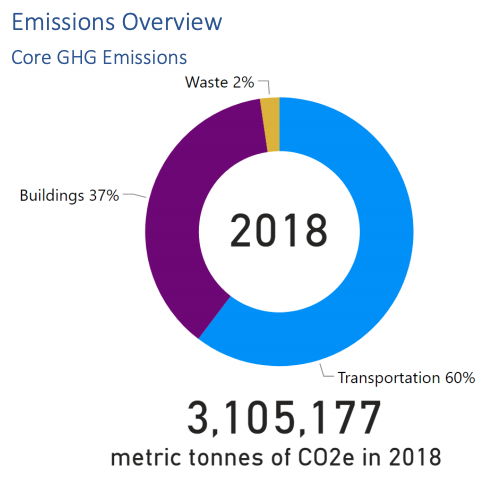
    Transportation emissions are 60% of the city’s core emissions but Seattle still lacks a concrete roadmap to achieve reductions. The Transportation & Utilities committee did make sure to find time to pass Seattle City Light’s transportation electrification plan, which certainly needs to be a part of the solution, but electric vehicles cannot be the entire solution, and Seattle is in a relatively advantageous position to show the rest of the country how it is done. Seattle’s reputation as being on the cutting-edge of urban design & innovation is wearing thin as our leaders choose the easy way forward.

    Transportation: 60% of core emissions

    The Biden administration is not going to prevent Seattle from building a new cruise ship terminal. Nor is it likely to stop the building of another regional airport even as emissions at Sea-Tac and King County airports have shot up 40% since 2008.

    Thinking of the incoming administration as the climate cavalry is backwards, and Seattle deserves better.

    — Advertisement —
  • 14th Ave’s Stay Healthy Blocks in Capitol Hill May Not Return

    2 street closure signs at opposite sides of an intersection
    Street closure signs in place along 14th Ave in November.

    Seattle’s network of Stay Healthy Streets, in place for most of this year on a portion of the city’s neighborhood greenway network, noticeably left out most of Seattle’s urban centers where a large proportion of the rental housing exists. Neighborhoods like the U District, Eastlake, First Hill, Northgate, South Lake Union, Uptown, and Capitol Hill either don’t have neighborhood greenways running through them or weren’t selected to be part of the Stay Healthy Street network.

    The Stay Healthy Block program, similarly named but separate, was created by SDOT to allow “residents, community-based organizations, and non-profits” to close a neighborhood street to create more outdoor space. At the beginning of November, SDOT issued a permit to Capitol Hill resident Christopher Hoffman allowing “street closure” signs to be placed on a long stretch of 14th Avenue south of Volunteer Park. The area extended from Prospect Street to Olive Street, with a one-block gap in the middle to accommodate the Safeway parking lot.

    Capitol Hill, pressed for open space in its densest segments, clearly had a pent-up demand for a space like this, and the street was an instant hit. All summer long, some residents had been daring enough to use the street to jog or stroll for a bit, but with the signs up the volume of pedestrians using the street skyrocketed even as temperatures outside went down.

    The stretch of 14th Ave that was opened to walking, biking and rolling in November.

    Unfortunately, the street signs also were instantly hit by cars, since their frames, provided by Seattle Neighborhood Greenways and not the city, were made of wood.  The signs were replaced multiple times, but not always right away, with broken signs often staying in the street for days. Some were clearly intentionally destroyed, with one “street closed” sign ripped to shreds.

    This past Monday morning, under threat of fine, Hoffman removed all remaining signage from 14th Ave despite the recent announcement from the city that the Stay Healthy Block program would be extended until the end of February. SDOT has not officially extended the permit past the end of November, and it’s not clear that a new permit will ever be issued.

    The primary issue with permit renewal is an odd provision of the Stay Healthy Block permit: SDOT’s rules only allow a street to be closed for twenty hours a week, though the times can vary but they can’t go past 9pm on any day. In other words, for the other 148 hours in a week, Seattle’s narrow sidewalks have to suffice if you like to use a Stay Healthy Block for exercise or transportation.

    (more…)

    — Advertisement —
  • Proposed Signal Policy Could Mean More Long Waits At Intersections

    The Seattle Department of Transportation has finalized a traffic signals policy intended primarily to improve mobility for people walking and rolling at intersections. This policy comes out of a process that the agency convened with a group called the Policy and Operations Advisory Group, which consists of members of the different modal advisory boards, the transportation equity workgroup, the pedestrian access advisory committee and a few other groups with a stake in SDOT policy.

    The policy update includes some benefits that will be seen citywide, but the policy falls short of the promise of revamping signal timing with the goal of moving people over vehicles. A major shortcoming is in the proposed signal lengths, aka the amount of time for a traffic signal to complete a full cycle if you just missed it. Within the middle of Seattle’s densest neighborhoods, a single length of two minutes would be standardized, with a length of even two and a half minutes permitted.

    Cycle lengths would be lowest at intersections along streets downtown, with a target of 50-90 seconds, but a maximum signal length of a minute and a half is still very high for the highest volume streets for pedestrians. Urban village neighborhood streets and neighborhood corridors, which include streets like Broadway in the heart of Capitol Hill (which coincidentally has the highest pedestrian volumes of any street in Seattle in recent years), would be able to have longer signal lengths than in downtown. Streets with an urban village main or urban center connector designation (like Rainier Ave S or College Way N) would be able to have longer cycle lengths still. Industrial access streets like 15th Ave W able to have the longest cycle lengths, up to three minutes.

    Chart showing the different signal lengths as described in the article
    Signal lengths by street type as proposed by SDOT.

    You can use the chart above to match street type designations with this this interactive map to see what the cycle lengths could be on any specific street.

    One factor influencing these proposed cycle lengths is a big change that SDOT is proposing to make all every single intersection in Seattle: reducing the standard pedestrian speed used to calculate how much time is provided to cross from 3.5 feet per second to 3 feet per second. The policy will also include a secondary calculation to ensure that someone standing six feet back from the intersection would be able to cross the street using a speed of 2.5 feet per second and use this to adjust total time provided to cross. This should provide more time to cross most intersections that get revised under the policy.

    Infographic laying out the change from 3.5 feet to 3 feet per second
    This illustration lays out SDOT’s proposed changes to crossing time calculation.

    SDOT says that implementing this policy “should reduce wait times and provide more frequent opportunities for pedestrians to cross the street”, while having the effect of “slight increase in delay and travel time” for transit and freight traffic.

    But the proposed cycle lengths for urban villages and centers exceed the range noted as ideal by the National Association of City Transportation Officials (NACTO), which says “longer signal cycles and corridor-based timing schemes make large avenues into barriers that separate neighborhoods rather than joining them”. NACTO notes that 60-90 seconds is ideal for urban areas. SDOT should reassess whether intersections outside downtown in most cases need to have a targeted signal length of more than a minute and a half, and at a minimum bring down the very high max cycle length.

    Seattle Neighborhood Greenways has set up an action alert on the proposed signal policy’s shortcomings, which you can use to contact SDOT directly here.

    — Advertisement —
  • Segment of Lake Washington Blvd To Reopen December 18-January 4

    SDOT has just announced that it will be closing a small segment of Lake Washington Boulevard between Mount Baker Beach and Stan Sayres Boat Launch (at 45th Ave S) starting this Friday December 18 and running through Sunday January 4. This is the same segment of Lake Washington that was closed over Thanksgiving weekend, and is a shortened segment of the 3-mile Keep Moving street that SDOT piloted over the summer that extended all the way down to Seward Park.

    Another small segment of the street between the boat launch and 50th Ave S is designated “local access” with signage but will still allow vehicles.

    Map showing closed Lake Washington Boulevard
    The segment of Lake Washington Boulevard closed to cars.

    These temporary closures are clearly intended to provide extra open space around holidays but they also serve a transportation need in a segment of town without a reasonable safe north-south bike route. The narrow pedestrian path along Lake Washington boulevard is also inadequate for people who want to maintain six feet from other around them. Many are calling for at least a portion of the street to be made permanently car-free.

    The city continues to have a protracted conversation about the future of Lake Washington Boulevard as a place where people that aren’t in personal vehicles are prioritized. Last week the parks board, which technically controls the land that the street is on, discussed the issue, and the Twitter thread from Erica C. Barnett is worth your time.

    — Advertisement —
  • Seattleites Driving Fewer Miles Than Ever, City Report Suggests

    The city of Seattle just released a new report on our citywide carbon footprint. The info in the report is slightly out-of-date, as it’s a snapshot of how we did in 2018, but is the most comprehensive picture we have of how the city is meeting, or rather failing to meet, its carbon reduction goals.

    The report includes one significant piece of info that should be encouraging to transportation advocates: the number of miles of vehicle travel for each Seattle resident sunk to its lowest level in decades in 2018. Every single Seattle resident’s share of the miles travelled on city streets was just over 6,000 miles after a likely peak of 7,400 in 2005. This is clearly a result of transportation policy decisions, light rail and the success of the Seattle Transit Benefit District central among them, that drove drive-alone commute rates to record lows.

    Chart showing dropping per capita VMT between 2005 and 2018, ending at just above 6000
    Vehicle miles travelled per capita in Seattle since 2005

    Now for the bad news: due to Seattle’s population increasing, total VMT in Seattle is still continuing to go up even as everyone’s individual share is going down. Per capita miles travelled has gone down 11% since 2008 but overall VMT is up 12%.

    Seattle’s goal for miles travelled in the 2013 Climate Action Plan is a 20% drop in overall passenger VMT (separate from freight miles travelled) by 2030. In order to meet the 2030 target, there would need to be a drop of more than 200 million miles per year until 2030.

    (more…)

    — Advertisement —
  • RapidRide J Line Shortening Leaves Roosevelt Bike Connection Hanging

    The recent news that one of the centerpiece transit upgrade projects of the Move Seattle levy, the RapidRide J line- formerly known as Roosevelt BRT- would see its route shortened was another big blow to the transit segment of the levy. Roosevelt BRT will not even reach the Roosevelt light rail station, instead terminating at the U District light rail station. That news comes on the heels of the city giving up entirely on turning 3 current bus routes into RapidRide lines in 2018, and news this year of the route 7’s upgrade being put on hold. The number of broken promises in the transit component of Seattle’s largest-ever transportation levy continues to grow.

    But this is unfortunate news for the hopes of completing a critical bike connection between brand new light rail stations in north Seattle as well. Since 2016, Roosevelt Way NE has had a protected bike lane between NE 65th Street and the University Bridge, just waiting for the light rail station at Roosevelt. But Roosevelt is only a southbound bike lane, and RapidRide J was set to upgrade the paint bike lane on 11th Ave NE, finally completing the couplet. Now it’s not likely that will happen anytime soon.

    The RapidRide J line, including the bike lane component, will not change south of the University Bridge, meaning that a full bike connection along Eastlake Ave is still planned. This will complete a hugely critical connection that will have massive citywide benefits, despite considerable opposition to parking removal along Eastlake. Earlier this year, Mayor Durkan herself voiced clear support for installing protected bike lanes on Eastlake, hopefully indicating that another downgrade isn’t likely.

    Updated route map in the U District for RapidRide J
    The RapidRide J line will terminate at U District Station instead of Roosevelt Station.

    (more…)

    — Advertisement —
— Advertisement —

Join the Seattle Bike Blog Supporters

As a supporter, you help power independent bike news in the Seattle area. Please consider supporting the site financially starting at $5 per month:

Latest stories

— Advertisements —

Latest on Mastodon

Loading Mastodon feed…