— Advertisement —
  • Bike Route Alert: Lynnwood Link construction will close Scriber Creek Trail for 2 years, disrupt Interurban Trail

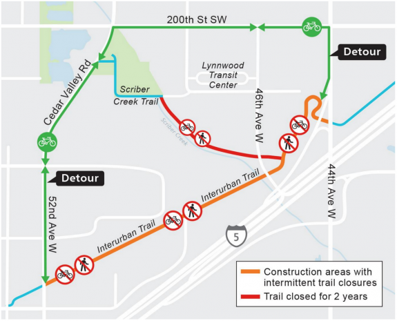
    Map of the planned closures and detours near Lynnwood Park and Ride.Work on Lynnwood Link will close the Scribner Creek Trail for two years and will require intermittent closures of the Interurban Trail, Sound Transit says.

    The Scribner Creek Trail is basically a path along the southwest edge of the Lynnwood Park and Ride parking lot that connects to the Interurban Trail. So if you don’t recognize the name, you may use this trail if you access the trail from the park and ride.

    The more significant impact, though, will be the series of Interurban Trail closures in the area over the years of construction. The first such closure is scheduled for late October and will last two weeks, but later closures could last up to 6 months. And the detour route includes a busy stretch of 200th Street SW and the sidewalk of 44th Ave W (there is no curb cut from 44th to the trail, so the sidewalk is the only option unless Sound Transit adds a ramp). Maybe there will be an unofficial way to weave through the park and ride area to skip some of the detour, but the official detour map doesn’t suggest an alternative.

    Details from Sound Transit: (more…)

    — Advertisement —
  • Seattle knew 5 years ago that a Rainier Ave safety project would save lives, but is just now starting work

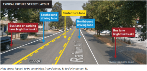
    Diagram of the new road layout with bus lanes and a center turn lane.Rainier Ave S has long held a terrible title: The most dangerous street in Seattle. It saw more crashes per mile than the city’s other deadly streets, including Lake City Way and Aurora, despite carrying far fewer trips.

    “During a 6-month study in 2015, on average, there was 1 crash per day that took 45 minutes to clear,” SDOT wrote on the project website.

    Despite being the central commercial street for many Rainier Valley neighborhoods, Rainier Ave was designed like a highway. With multiple lanes in each direction and no center turn lane, the street encouraged speeding and prioritized people traveling through the neighborhood over people trying to make turns or cross the street. So not only were there a lot of crashes at high speeds, but they were often the most dangerous kind (pedestrian, cyclist, head on and left turn collisions). The result has been decades of people dying and being seriously injured with little to no action to prevent them.

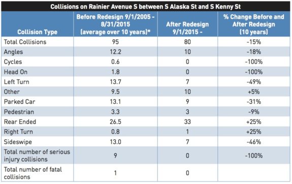
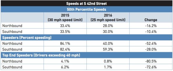
    Then in 2015, Seattle redesigned a stretch of Rainier Ave S in Columbia City to reduce collisions along one part the street. It took an enormous amount of political pressure, including a protest in Columbia City, to convince the city to take action and redesign the street. And the results were jaw-dropping. Just by repainting the lines and changing some signs, SDOT’s Vision Zero team was able to reduce dangerous collisions and speeding by huge percentages. But most notably, this stretch of the street averaged 9 serious injuries and 1 death every year before the changes. The project reduced that to zero.

    Chart showing before and after collision counts on Rainier Ave following a 2016 safety project.With such an incredible success, the city immediately went out and completed this safety project along the rest of the street, right? The logical and compassionate response to the results in these charts would be to all but declare a public health crisis and fix the rest of the street immediately before more people get hurt. If this were a medical study, researchers would have taken one look at these results, stopped the study and then immediately administered this obviously effective medicine to all patients. Because physicians have a sworn ethical duty to do no harm, and every number in these charts represents a real human being with people who love them. Even one should be considered unacceptable.

    But there is no Hippocratic Oath for people making transportation policy. It is considered acceptable to knowingly allow people to die preventable deaths in traffic, and therefore such deaths are not treated like an emergency. (more…)
    — Advertisement —
  • SDOT: Keep Moving Streets extended until October 5

    Chart showing increased bike use on Lake Washington Blvd during the Keep Moving Street program.
    From SDOT.

    Seattle’s car-light Keep Moving Streets have been a success, so the city has extended them another month.

    Created in partnership between SDOT and Seattle Parks, the city’s four Keep Moving Streets are typically on arterial streets near parks or along waterways that don’t have enough sidewalk space to safety handle all the people who want to use them. Streets, on the other hand, have lots of space. So the city decided to try closing streets to through traffic (local access is allowed) and open that space to walking and biking.

    And people love it.

    The program has been extended until October 5. But there’s no reason to think they won’t be needed beyond that point. Neighbors of the Alki Point project even put together a campaign to make it permanent (complete with a video).

    More details on the October extension from SDOT: (more…)

    — Advertisement —
  • Bike Route Alert 9/11-14: 520 Bridge closed, including the trail

    Map of the 520 Bridge closures.The 520 Bridge will be closed 11 p.m. September 11 until 5 a.m. September 14 for a series of major construction projects. These closures include the trail over the lake.

    The trail under the bridge on the Montlake side connecting Shelby/Hamlin to Lake Washington Blvd will be open during the daytime, but will close at night.

    Details from WSDOT:

    Reminder to travelers: SR 520 will completely close for construction between Seattle and the Eastside from 11 p.m. Friday, Sept. 11, to 5 a.m. Monday, Sept. 14. During that weekend, crews will repair a damaged sign bridge that goes over all lanes of SR 520, realign Montlake’s eastbound SR 520 on-ramps, restripe a section of the westbound lanes, and more. Check out our latest video to learn more.

    What travelers should expect:

    • All east- and westbound lanes will be closed between Montlake Boulevard and 92nd Avenue Northeast near Medina.
    • The SR 520 Trail will be closed across Lake Washington.
    • The temporary path under SR 520 between East Montlake Park and Lake Washington Boulevard will be open during the daytime, with flaggers present, so please use caution. This path will close at night.
    • SR 520 will remain open between I-5 and Montlake Boulevard.
    — Advertisement —
  • Saturday: Peace Peloton rides from NE Seattle to White Center + Fundraiser

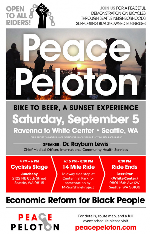
    Event poster. Details in the story.Mmmmm… Junebaby is so good. And Saturday’s Peace Peloton starts at the NE Seattle restaurant in the early evening, then rides to Beer Star in White Center.

    Dr. Rayburn Lewis will be speaking this week, a former Cascade Bicycle Club Board member who is Chief Medical Officer at International Community Health Services.

    As always, the ride is focused on supporting Black-owned businesses and promoting economic reform for Black people.

    Meet at Junebaby between 4 and 6 p.m. Pre-order food from the Junebaby website (seriously, it’s so good). The ride is 14 miles with a midway stop in Centennial Park. Riders will roll into White Center around 8:30.

    It will be getting dark by the end, so make sure you bring bike lights.

    And hey, wanna support the cause financially while also getting a chance to win a pro’s bike? You can! $50 gets you one chance to win Tejay van Garderen’s 2019 Cannondale Supersix EVO Race bike, and their goal is to raise $25,000. More details here. (more…)

    — Advertisement —
  • Construction begins soon on initial segment of the 4th Ave bike lane

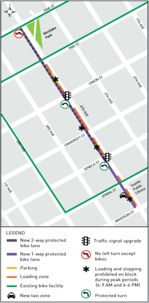
    Project map.Crews are gearing up to build a protected bike lane on 4th Ave between Pine and Madison Streets downtown.

    This is the start of the second north-south bike corridor downtown and a key piece of the Basic Bike Network vision, which would build a connected web of protected bike lanes from Seattle Center to the International District and places in between, helping more people bike to more homes, workplaces and destinations within our state’s busiest area.

    Though 4th and 2nd Avenues look close together on a map, the topography on the ground puts them in different realms. At Pine Street, the streets are basically at the same elevation. But the two blocks separating them at Madison are some of the steepest streets in the entire city. So for people trying to access major institutions, like the Seattle Public Library or City Hall, or heading further up to First Hill, 4th and/or 5th Avenues are vital.

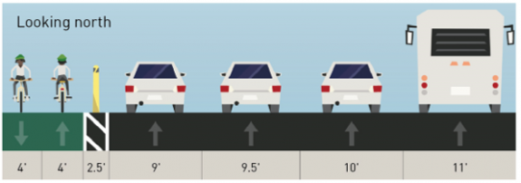
    The first segment will be a two-way bike lane on the west side of the street between Pine and Madison, essentially mirroring 2nd Ave.

    Cross-section of the proposed road changes.There is currently an uphill painted bike lane on 4th Ave that ends at Spring, so this project will connect to that old bike lane for the time being. That should be a huge improvement for people heading northbound who currently have to either merge into the left general purpose lane and bike in mixed traffic or try to merge across the entire street in front of the library in order to ride in the bus lane. Neither option is good. Being able to simply continue straight into a protected bike lane should be a massive improvement. (more…)

    — Advertisement —
— Advertisement —

Join the Seattle Bike Blog Supporters

As a supporter, you help power independent bike news in the Seattle area. Please consider supporting the site financially starting at $5 per month:

Latest stories

— Advertisements —

Latest on Mastodon

Loading Mastodon feed…