— Advertisement —
  • Trail Alert 4/27-5/11: Significant delays on Sammamish River Trail for repair work in Bothell

    Map of trail work zone.Work to fix some tree root bumps and repave a section of the Sammamish River Trail in Bothell kicks off April 27 and will last for two weeks.

    During work hours, trail users will need to wait for up to 15 minutes before crews can let them through. There will not be a detour.

    The trail is currently closed for recreation as part of King County Parks’ agency-wide closure that began in late March. People making essential trips or traveling to and from essential jobs are still allowed to use the trails for transportation.

    More details from King County Parks spokesperson Doug Williams:

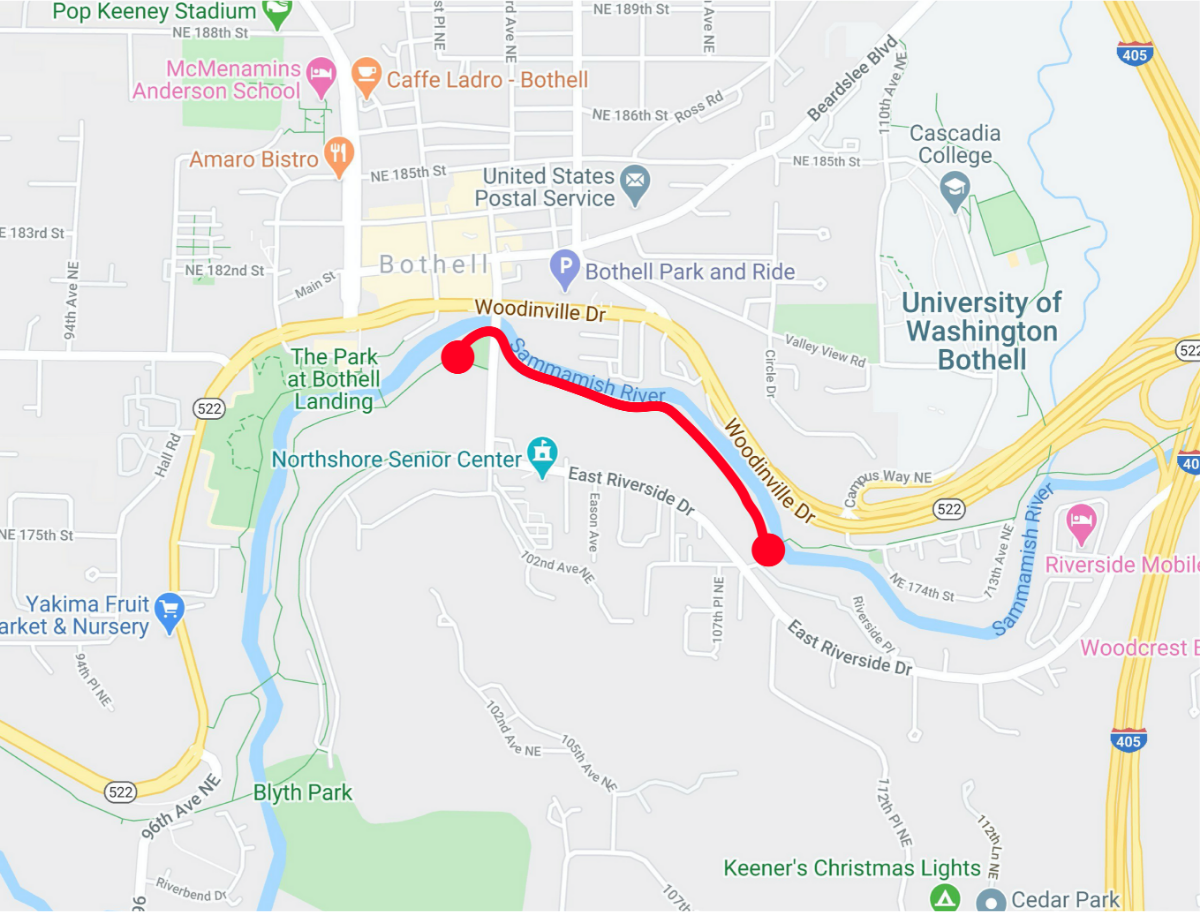
    Starting next Monday, April 27, we’ll be removing root incursions and resurfacing a short stretch of the trail (less than 100 yards long) near the “Chicken Lot.” The stretch we’ll be working on is at Sammamish River Park adjacent to 102nd Avenue Northeast, and east to the bridge that crosses the river. (See the map below.)

    Construction is going to take place Monday through Friday from 8 a.m. to 5 p.m., for two weeks – as long as the weather holds. If we get significant rainfall, the project would likely have to be extended to make up for lost work time.

    A flagged trail detour isn’t possible at this location. Instead, we will have flaggers and intermittent closures to allow trail users through the construction zone in 15-minute increments.

    The contractor will have temporary control signage (“construction ahead, expect delay,” “bicyclists dismount,” etc.), and flaggers will control trail user flow through the construction zone. Bicyclists will be asked to dismount and walk through the work site.

    Even though the regional trail system remains closed to everything but essential trips (work, doctor’s appointments, etc.), we’re concerned that trail use will increase with the improving weather. This can create an issue at the construction site because all trail users will have to be stopped together for several minutes while work is being done before they can safely walk through the construction zone.

    With that in mind, we’d appreciate your help in getting out the message about limiting non-essential trips along this portion of the Sammamish River Trail during the construction timeframe

    I know it’s an inconvenience to have a stretch of trail closed like this for construction, but with reduced trail use as part of the Governor’s Stay Home, Stay Healthy guidance, we can get this important safety work done now, rather in the summertime when trail use is exponentially higher.

    We’ve also lined up the timing of this project to coincide with a City of Bothell project to replace the pedestrian bridge in the Park at Bothell Landing.

    — Advertisement —
  • Watch: Talking open streets during COVID-19 with Gordon and Clara from SNG

    Seattle Neighborhood Greenways has been working with local advocates to develop ideas for open streets as a way to relieve crowding on sidewalks, paths and major parks during the outbreak. We previously reported about some of their ideas, and the organization is still accepting open streets ideas via their online survey.

    Since taping this interview with Gordon Padelford and Clara Cantor of Seattle Neighborhood Greenways, SDOT has announced their Stay Healthy Streets program to open a set of residential streets to walking and biking 24/7. Similar to Oakland’s Slow Streets program, Stay Healthy Streets will be closed to through-traffic but open to local access.

    The city is starting with two streets in the Central District and West Seattle, but has plans to expand the program to include 15 miles “in the coming weeks.”

    Maps of the first two Stay Healthy Streets.

    — Advertisement —
  • With the West Seattle High Bridge closed until at least 2022, talks begin about building a replacement

    Diagram showing where the structural problems are on the bridge.
    From SDOT.

    As we learn more about the unexpected and sudden closure of the West Seattle High Bridge at the end of March, it’s looking more and more like the decision to close the bridge prevented a horrific tragedy. Cracking on both sides of the support structure of the longest span was on a path to meet at the center. And if that happened, engineers said, the structure could have collapsed. That’s six lanes of traffic on the city’s busiest non-interstate bridge plummeting from a ridiculous height.

    I’m sure there will a lot of investigation into how the bridge got to this point and whether the city could have prevented it. But first, we need to acknowledge that inspectors and the city’s transportation chain of command made a very good call by closing it when they did.

    The cracking immediately slowed when traffic stopped, but it has continued. The bridge itself is so massive that it makes up a huge percentage of the total load on the structure, so removing traffic can only do so much. This is also why they are not going to be opening the bridge to walking and biking. You don’t want to be up there.

    The high bridge will be closed at least through 2021, and this means biking will only become more important for West Seattle as the path over the low bridge remains one of the best ways to cross the Duwamish River. See our previous story and video, in which Anthony Palmieri of West Seattle Bike Connections walks through some popular bike routes in the neighborhood.

    The city announced Wednesday that it will cost $33 million to maintain the lower swing bridge (which is prone to failures itself), change traffic controls, and to stabilize the bridge so it doesn’t fall down on its own and can handle the workers and equipment needed to make a bigger and more expensive fix.

    City engineers are also not confident that they can repair the bridge at all, and they definitely cannot fix it well enough to make it operational for its full expected life span, which should have had it operational until the 2050s or 2060s. If they can repair it at all, the city doubts they could get more than 10 years out of it. So conversations are already starting about replacing the bridge entirely, an effort that will be measured in hundreds of millions of dollars. Which we don’t have. (more…)

    — Advertisement —
  • Cascade survey: How have your walking and biking needs changed during the outbreak?

    Screenshot from the survey.
    Take the survey.

    survey from Cascade Bicycle Club asks people how their relationship with walking and biking has changed since the outbreak began and seeks ideas for how Cascade can help during this time.

    As we reported previously, Cascade furloughed half their staff out of worries that they may need to cancel many or all of their major events this summer. Executive Director Richard Smith said they typically need to make a decision about whether to hold or cancel an event one month before it happens, so stay tuned for updates.

    May is typically Bike Month, which Cascade and its sister organization Washington Bikes pack with various events including Bike Everywhere Day. Cascade has pushed the entire month of events back into June, including Bike Everywhere Day on June 19. But again, all of this is contingent on social distancing guidance at that time, so stay tuned.

    From the survey: (more…)

    — Advertisement —
  • What kind of bike lanes should SDOT build on MLK between Rainier and Judkins Park (in 2023)?

    Project map.I know it’s pretty hard to think about 2023 right now. Because a month lasts about a year right now, 2023 is more than 30 years away.

    But SDOT is currently conducting a survey about the planned MLK Way S bike lane between Rainier Ave S and S Judkins St even though they don’t plan to build the project until 2023 ahead of the Judkins Park light rail station opening. But they are getting a head start on planning.

    The survey is short and asks participants about the safety issues they face on the street, then offers a handful of options for how the planned bike lane could work.

    One option has a two-way bike lane on the east side, another has a two-way bike lane on the west side and a third option has one-way bike lanes on each side of the street.

    Diagrams comparing the options. (more…)

    — Advertisement —
  • The Untokening outlines ‘mobility justice responses to COVID-19’

    Screenshot of the Mobilty Justice Responses to COVID-19.
    The more about the Mobility Justice Responses to COVID-19 from The Untokening (PDF).

    The most marginalized people and communities in our society are especially stretched thin and put at increased risk during this outbreak. As unemployment soars, people without a safety net are in a very precarious position. And those with essential jobs who typically rely on transit face serious challenges and difficult choices just to get around.

    So as all levels of government are making emergency changes to the transportation system, it is vital that decision makers, agency staff and community leaders keep marginalized communities and vulnerable people at the forefront of each change. And The Untokening has some ideas for how to do just that.

    The Untokening is a “a multiracial collective that centers the lived experiences of marginalized communities to address mobility justice and equity.” Their “Mobility Justice Responses to COVID-19” were developed based on a broader and powerful set of mobility justice principles the collecting developed together over the course of years. So as changes and responses are developed, people at every stage should hold these principles in their minds.

    From The Untokening: (more…)

    — Advertisement —
— Advertisement —

Join the Seattle Bike Blog Supporters

As a supporter, you help power independent bike news in the Seattle area. Please consider supporting the site financially starting at $5 per month:

Latest stories

— Advertisements —

Latest on Mastodon

Loading Mastodon feed…