— Advertisement —
  • Lime takes over JUMP as part of big Uber investment deal

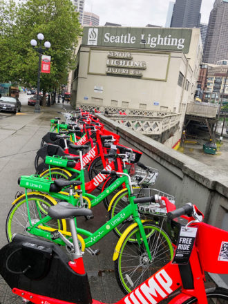
    Photo of a row of Lime and JUMP on the sidewalk of 2nd Ave Ext just north of Jackson Street.
    Lime’s green bikes are gone, but now the company owns JUMP and its formerly-competing red bikes.

    Seattle’s final operational bike share service just changed hands in yet another major shakeup in the private bike share saga.

    Uber led a $170 million investment in a majorly devalued Lime, and Lime will take on Uber’s JUMP bike and scooter service as part of the deal. Though no valuation was made public, The Information reports that Lime’s value had dropped to $510 million, 79% lower than its valuation during its previous round of investments.

    It’s not yet clear what this means for JUMP bike share service in Seattle, given that scooter-focused Lime pulled its own competing e-bikes from Seattle streets in December. Will Lime see this an opportunity to get back into bikes with better bikes? Lime’s e-bikes were often broken and had some dangerous battery fire problems. The company’s bike operations in Seattle never seemed to recover from a summer 2019 warehouse fire caused by an exploding battery.

    Or will Lime kill JUMP and continue focusing on scooters? If they do, that could essentially be the end of fully private bike share. Lyft owns Motivate, the operator of major systems like Biketown in Portland, Citibike in New York and Divvy in Chicago. But though Lyft has long been in the permitting process for launching in Seattle, they have not done so.

    For now, JUMP bikes can still be unlocked using the Uber app, though Lime announced on Twitter that users will soon be able to unlock JUMP bikes through the Lime app: (more…)

    — Advertisement —
  • King County will reopen trails Friday

    King County Parks will reopen regional trails and many parks tomorrow (Friday), the department’s first significant openings since closing all parks in late March.

    The county’s network of regional trails had been closed to recreation, though essential workers and people making essential trips were allowed to use them for transportation. Now they will reopen for recreation use, though users must follow social distancing protocols and be sure to avoid crowding. Restrooms will remain closed.

    The news follows Washington State’s decision to reopen many parks, trails and other public lands to daytime recreation.

    Seattle never closed its trail network, instead making an effort to create more open space for walking and biking in neighborhoods through its Stay Healthy Streets program. It has been a bit confusing to have city trails open and county trails closed since many users are not aware which agency maintains which trails. Hopefully the outbreak numbers don’t surge again and prompt more park and trail closures.

    Here are King County Parks’ tips for using parks and trails safely: (more…)

    — Advertisement —
  • City develops emergency plan in case the West Seattle Bridge falls

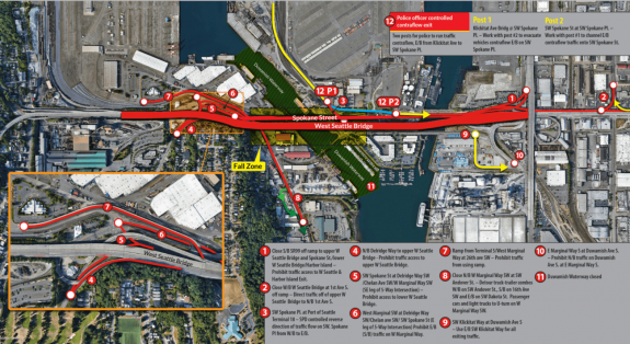
    Map showing the bridge fall zone.
    From SDOT.

    The city of course hopes it never comes to this, but they are planning for a worst case scenario in which the bridge becomes so unstable it could collapse.

    After studying the extensive cracking on the West Seattle High Bridge that prompted its emergency closure in late March, SDOT has installed monitoring devices to alert them of further movement. And they are preparing a plan to evacuate nearby areas and close the lower swing bridge that is now a lifeline for the neighborhood, providing a walking, biking, transit, freight and emergency vehicle connection.

    “[T]here are currently no indications that we will need to put our emergency response plan into action,” SDOT wrote in a blog post describing the new plan. The plan includes three potential responses based on possible emergency circumstances:

    • Immediate evacuation to be used if the daily in-person inspections indicates enough of a change to warrant the immediate evacuation of a small number of properties (details shared below), though we could have hours or days before actual bridge failure.
    • One to five days notice to be used if the new remote monitoring instrumentation, which will be fully functioning in mid May, indicates enough of a change to warrant execution of evacuation plans within one to five days. If failure is anticipated, but not immediate, SFD and SPD will clearly communicate, via direct site visits and other platforms, when evacuation must occur.
    • Controlled demolition to be used if the change in the condition of the high bridge indicates the need for execution of an evacuation plan followed by a controlled demolition.

    Here’s what the emergency road closures would look like:

    Map of road closures.Let’s hope it doesn’t come to this. But the fact that SDOT has even created this plan gives you an idea of how bad the damage is.

    If you want to make sure you are alerted if the plan goes into effect, sign up for AlertSeattle text messages. You should also make sure Wireless Emergency Alerts (the service that sends Amber Alerts) are enabled on your phone.

    — Advertisement —
  • Crowdsourced map highlights 130 miles of potential Stay Healthy Streets

    Map showing crowdsourced streets for Seattle Stay Healhty Streets.
    Green = Stay Healthy Street. Blue = Convert parking lane to walk/bike path. Purple = Convert travel lane to walk/bike path. View interactive map from Seattle Neighborhood Greenways.

    Seattle Neighborhood Greenways has been collecting people’s ideas for street improvements the city could make to help more people get outside and get around safely during the outbreak. They received 250 ideas, which they condensed into a map of 130 miles of car-light Stay Healthy Streets and temporary on-street walk/bike paths designed to relieve crowded sidewalks that are not wide enough for people to maintain six feet of separation as public health guidelines require.

    “Narrow sidewalks (97% of Seattle’s sidewalks are too narrow for people to safely pass each other), missing sidewalks (the case for about ¼ of the city), and crowding at local parks and trails have made it difficult for local residents to enjoy fresh air and recreation at a safe social distance,” SNG wrote in a press release announcing the map.

    The map is filled with good ideas. The biggest missing piece I see is Sodo, where there is huge potential in connecting Georgetown to downtown, helping many people avoid driving on streets that are now far busier due to the emergency West Seattle Bridge closure. Though perhaps this is more of a West Seattle Bridge-related project and less of an outbreak-related project. But no matter the reason, it would help people get around safely and affordably during these difficult times.

    “Transportation comes in second only to housing for major household expenses in Seattle,” said SNG’s Clara Cantor in the press release. “And now, especially, with finances tight for folks, walking and biking are the most affordable means for getting to work for many of our city’s essential workers. We’ve got to make sure people can get where they need to go safely.”

    And creating Stay Healthy Streets has proven to be effective, affordable and low-maintenance, important during a time when city resources are stretched thin.

    “The expense is low—one driver in a city truck, distributing a traffic cone and two street signs to each intersection—and the payoff is so high,” said SNG Director Gordon Padelford in the press release. “We’re receiving loads of stories and photos of how people are making use of, and enjoying, the extra space for outdoor recreating. Right now, only a handful of neighborhoods are benefiting from the Stay Healthy Streets program. We really want to see this expanded to reach the whole city.”

    Seattle Bike Blog spoke with Cantor and Padelford about open streets during the outbreak  recently, so be sure to check out that video. (more…)

    — Advertisement —
  • Some trails, closed amid statewide parks shutdown, will reopen for day use Tuesday

    Washington State is preparing to ease a few restrictions for the first time since the outbreak began, and reopening day use of many parks and trails are at the top of the list. Starting tomorrow (Tuesday), major statewide trails like the Palouse to Cascades Trail (AKA the Iron Horse Trail AKA John Wayne Pioneer Trail) will open during the daytime, though some trailheads (including the popular Cedar Falls Trailhead near Rattlesnake Lake) remain closed.

    Recreational lands managed by the Department of Natural Resources will also reopen for day use Tuesday. You can find updated information on what’s open and closed via the state’s COVID-19 response website.

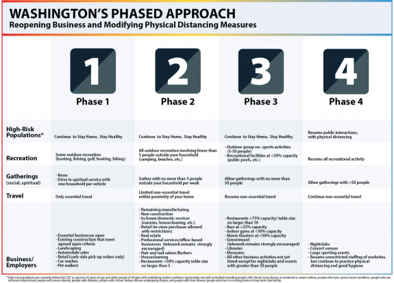
    Washington's four-phase plan for reopening. PDF version linked in caption.
    From Governor Jay Inslee’s Office (PDF).

    Camping remains prohibited during Phase 1 of Governor Jay Inslee’s four-phase plan to relax restrictions, though it is listed as part of Phase 2. Many major trailheads and popular parks will also remain closed, as will many restrooms.

    Of course, people need to keep following social distancing and hygiene practices to prevent the outbreak numbers from surging again, setting us all back and delaying progress. The selfish whiny babies gathering together to protest the state’s restrictions by … purposefully spreading the virus? … may very well send us all backwards in our reopening process if those gatherings create a surge in the number of cases.

    If you do go out and use parks and trails, you have to maintain social distancing practices, of course. That means being prepared to let your plans fall apart if you get somewhere and it is too crowded. In general, it is still probably best to stay near your home, perhaps by utilizing one of the city’s Stay Healthy Streets.

    King County Parks remain closed, including county-operated trails (though essential workers and people making essential trips can still use them for transportation). However, King County Parks does note on its website that they are “working through a phased-in reopening scenario for its parks, trails and other facilities, likely starting with natural lands and regional trails.” So stay tuned.

    Biking Bis has a good post about which trails are reopening and some distancing best practices from the Mountains to Sound Greenway Trust, so definitely check that out for more info.

    — Advertisement —
  • Episode 1 of Ask Seattle Bike Blog: Bus driver in West Seattle needs a bike route to the Sodo bus yard, so here’s my process for finding a new route

    For the inaugural episode of Ask Seattle Bike Blog, I respond to a bus driver who lives in West Seattle and wants to know a good bike route to the bus yard in Sodo.

    I thought this would be a good opportunity to walk through my basic process for planning a bike route if I am not familiar with the area. So even if you aren’t trying to bike this exact route, hopefully the process I follow is useful.

    What’s your process for finding a bike route to an unfamiliar place? How do you pronounce “Brougham?” Let us know in the comments below.

    If you have a bike-related question, send it our way using this submission form.

    — Advertisement —
— Advertisement —

Join the Seattle Bike Blog Supporters

As a supporter, you help power independent bike news in the Seattle area. Please consider supporting the site financially starting at $5 per month:

Latest stories

— Advertisements —

Latest on Mastodon

Loading Mastodon feed…