— Advertisement —
  • Crews are currently building Seattle’s most important new bike connection in years

    Map of the south downtown bike route, which travels from 2nd Ave to 5th Ave via S Main Street and from Main to King Streets on 5th Ave.
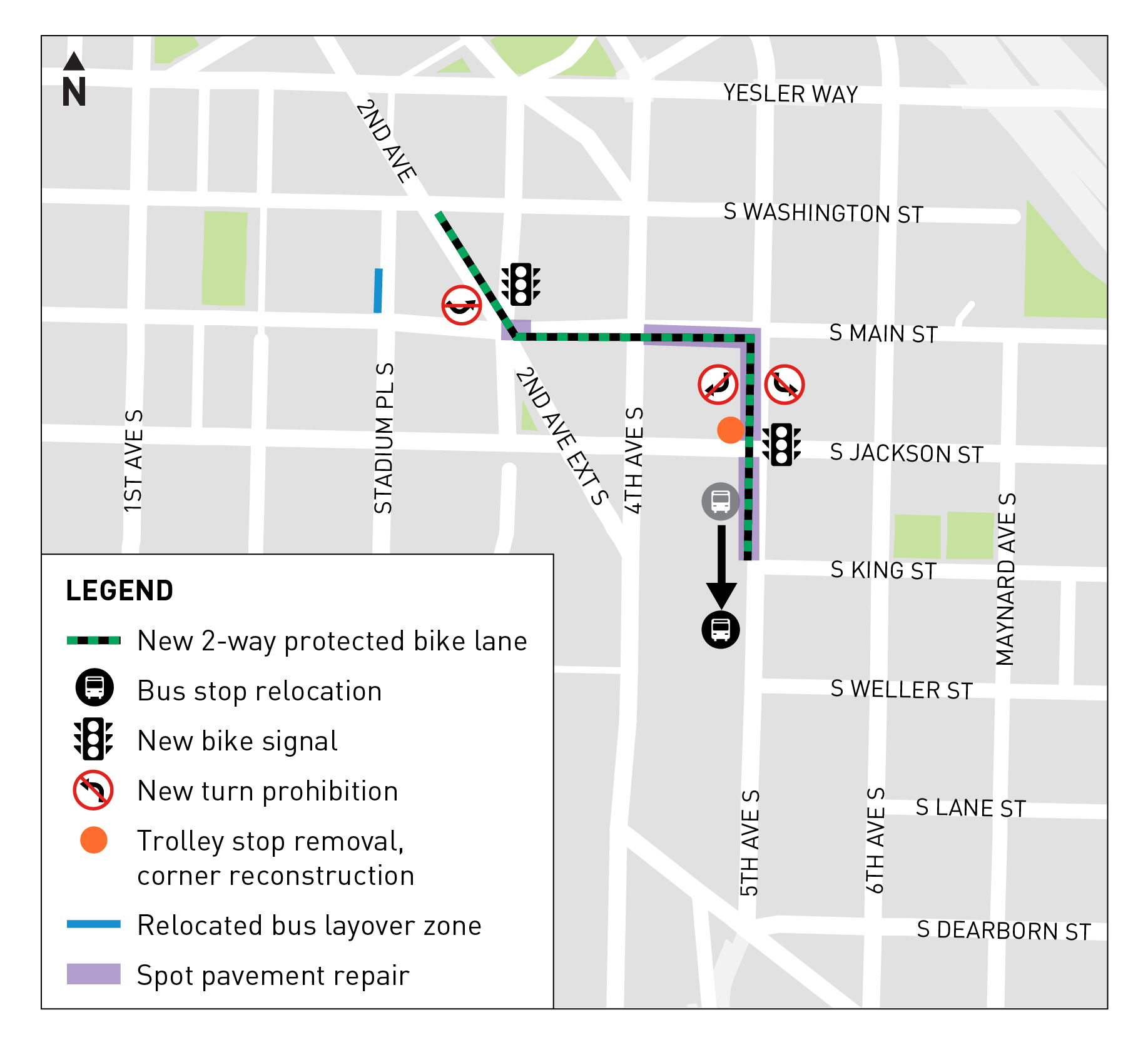
It may be short, but don’t let that fool you. The protected bike lanes currently under construction on a few blocks of S Main St and 5th Ave S between the International District and the 2nd Ave bike lane should easily be the most important improvements to bike access Seattle has completed since, well, 2nd Ave.

    It doesn’t really look like a difficult connection on a map because the International District looks like it’s just part of the downtown street grid. But once you’re on the ground on a bike, you realize there is no remotely comfortable or functional option for getting between the neighborhood and the downtown core on a bike. And since a connection from the ID also unlocks bike routes from many central and southend neighborhoods, the lack of a south downtown bike connection has huge potential for a lot of people.

    The problem is that the rail corridor separates the ID and Pioneer Square. And thanks to extreme grades up First Hill, the only flat street between the two neighborhoods — S Jackson St — has dangerous streetcar tracks. So people either need to ride in busy mixed traffic and hope they successfully navigate the streetcar tracks or try to ride on packed, skinny sidewalks. Both these options are bad. The only other option is to use the elevator (or stairs if you are able) next to the CenturyLink Field parking lot and cross the Weller St bridge, but this has obvious limitations (and is totally unusable if you have a family/cargo bike).

    Short of making Jackson a truly complete street (which of course we should do), the planned route is the best option. And as we reported a year ago, it has not been easy to get to this point. At the time, SDOT was proposing a ridiculously steep option via 6th Ave S, which looks similar on paper but requires an absurd climb compared to 5th Ave S. There were serious concerns that nobody would use this steeper route, which would be a waste of money and still leave this connection incomplete. It took a lot of persistent advocacy and inter-agency coordination to make this much better route happen.

    The defunct waterfront streetcar platform at 5th and Jackson had to be moved, sections of old streetcar tracks had to be repaved, busy bus stops had to move and precious bus layover space was displaced. None of this was easy. (more…)

    — Advertisement —
  • Bike News Roundup: Cities with more bicycling are also safer for everyone

    It’s time for the Bike News Roundup! Here’s a look at some of the stuff going around the web lately. On a personal note, I am in St. Louis for a funeral, so that’s why posts have been slower than usual. Things will be back up to speed soon.

    Pacific Northwest News (more…)

    — Advertisement —
  • Census survey: Biking, walking and transit up as commute data corrects itself + Driving alone down to 44.5%

    Last year, you likely saw a story (or many) saying that biking was way down in Seattle. That was due to the annual release of the Census Bureau’s annual American Communities Survey data, which can vary quite a bit year-to-year. And the 2017 figures were way down.

    But as we noted, these numbers were likely just outliers because they ran counter to the ten-year trend. And the 2018 survey results that just dropped seem to confirm that, with walking, biking and transit use significantly up compared to 2017.

    Just as it was inaccurate last year to say that biking was down to a ten-year low, it is also inaccurate this year to say that biking increased 35% in just one year. These dramatic ups and downs are almost certainly just statistical noise. In reality, the trend line for bike commuting is on a steady upswing, and the 2018 figures fall much more in line with the trend than 2017:

    Graph of raw bike commute estimates by sex, from the American Communities Survey. Both male and female trend lines are up, though the male trend like is growing faster.
    City of Seattle bike commuters by sex (the terminology used by the survey).

    More people in Seattle are biking as their primary way of getting to work than ever before. Both walking and transit use also continued their climbs in the 2018 survey. Walking to work is now up to an incredible 12% citywide, nearly double the rate in 2005. Public transit is closing in on a solid quarter of commutes, clocking in at 23%.

    And all this added together means walking, biking and transit is up to 39%, and driving alone to work continues its steep decline. Now just 44.5% of Seattle workers drive alone to work, down from 53% a decade ago. Even if the 2018 estimates end up being a bit high, Seattle is on trend for walking, biking and transit use to overtake driving alone just a few years from now, a feat very few U.S. cities have accomplished. (more…)

    — Advertisement —
  • Mayor Durkan’s 2020-21 budget would increase bike lane, Vision Zero, Northgate Bridge funds

    Replying largely on revenue from selling a large parcel of land made available by the massive Mercer Street project, Mayor Jenny Durkan’s proposed 2020-21 budget includes millions more for protected bike lanes, neighborhood greenways and other Vision Zero projects.

    These additions could help restore some of the major Bicycle Master Plan cuts her administration made in the recent years, including a list of south end and downtown projects that advocates fought hard to highlight in the city’s latest bicycle work plan. After cutting the projects entirely, SDOT and the mayor sort of added the projects back as funded through design, but not construction. The latest funds will be “prioritized for projects listed in the 2019 Bike Master Plan Implementation Plan as funded through design and/or planning,” according to a blog post from the Mayor’s Office. So that would be the dotted and gray highlighted areas in this map:

    Map of Seattle showing existing and planned bike facilities.
    Images from the 2019 Bicycle Master Plan Implementation Plan (PDF).

    It’s not yet clear whether the $8.35 million for protected bike lanes will be enough to restore all the projects or which ones will get priority over others. It’s also not yet clear whether these funds will sufficient fulfill the City Council’s recent resolution supporting a specific set of downtown and south end projects. But clearly this is better than the dismal outlook from the work plan the mayor released earlier this year. (more…)

    — Advertisement —
  • Cascade: Mercer Island plan should ‘futureproof’ I-90 Trail, open house Monday

    Concept images showing that the trail would remain its current width through the lid park with a two-foot soft buffer on each side. East of the town center, the trail would be 12 feet wide plus two-foot buffers on each side.
    From the draft Aubrey Davis Park Master Plan (PDF)

    When the I-90 Trail crosses Mercer Island, it climbs up and through a park created in the 1990s to cover the freeway. Posthumously named after and Island Councilmember and Mayor who negotiated with the state to include the lidded park, Aubrey Davis Park hides what would otherwise have been a freeway trench dividing the island from end-to-end.

    Mercer Island is nearing the end of its master plan update for the park, which covers the lid park and the section of the trail east of the town center. Cascade Bicycle Club is urging people to support a “futureproof” I-90 Trail design that follows modern best practices for multi-use trails. You can show up to support the trail in-person at an open house 6–8 p.m. Monday at the Mercer Island Community & Events Center.

    Specifically, Cascade is suggesting: (more…)

    — Advertisement —
  • Park(ing) Day 2019 is today! Here’s a map of all the temporary mini-parks around town

    Map of Park(ing) Day 2019 parks. Text list is in the post below.It’s Park(ing) Day! Go enjoy one (or many) of these temporary mini-parks and spend some time thinking about all the ways city space can do so much more than simply store some cars.

    Some parks will start closing in the afternoon, but some will be open until 7 p.m.

    Park locations list: (more…)

    — Advertisement —
— Advertisement —

Join the Seattle Bike Blog Supporters

As a supporter, you help power independent bike news in the Seattle area. Please consider supporting the site financially starting at $5 per month:

Latest stories

— Advertisements —

Latest on Mastodon

Loading Mastodon feed…