— Advertisement —
  • Watch: The new Pike Street bike lanes are just a glimpse into the community-led vision for Pike/Pine

    [video transcript]

    There’s something very different about the new protected bike lanes on Pike Street on Capitol Hill: Community groups led the process every step of the way. When former mayor Ed Murray slammed the brakes on the Center City Bike Network in 2016, which included bike lanes on Pike and/or Pine streets between downtown and Broadway, the volunteers at Central Seattle Greenways were not going to just allow progress on the lanes to wallow.

    Pike and Pine Streets connect the city’s densest employment, transit and destination center with some of the city’s most densely-populated neighborhoods, and the streets are lined with popular businesses. And though they are hilly, Pike and Pine are by far the least steep options available. So the potential on these streets is huge.

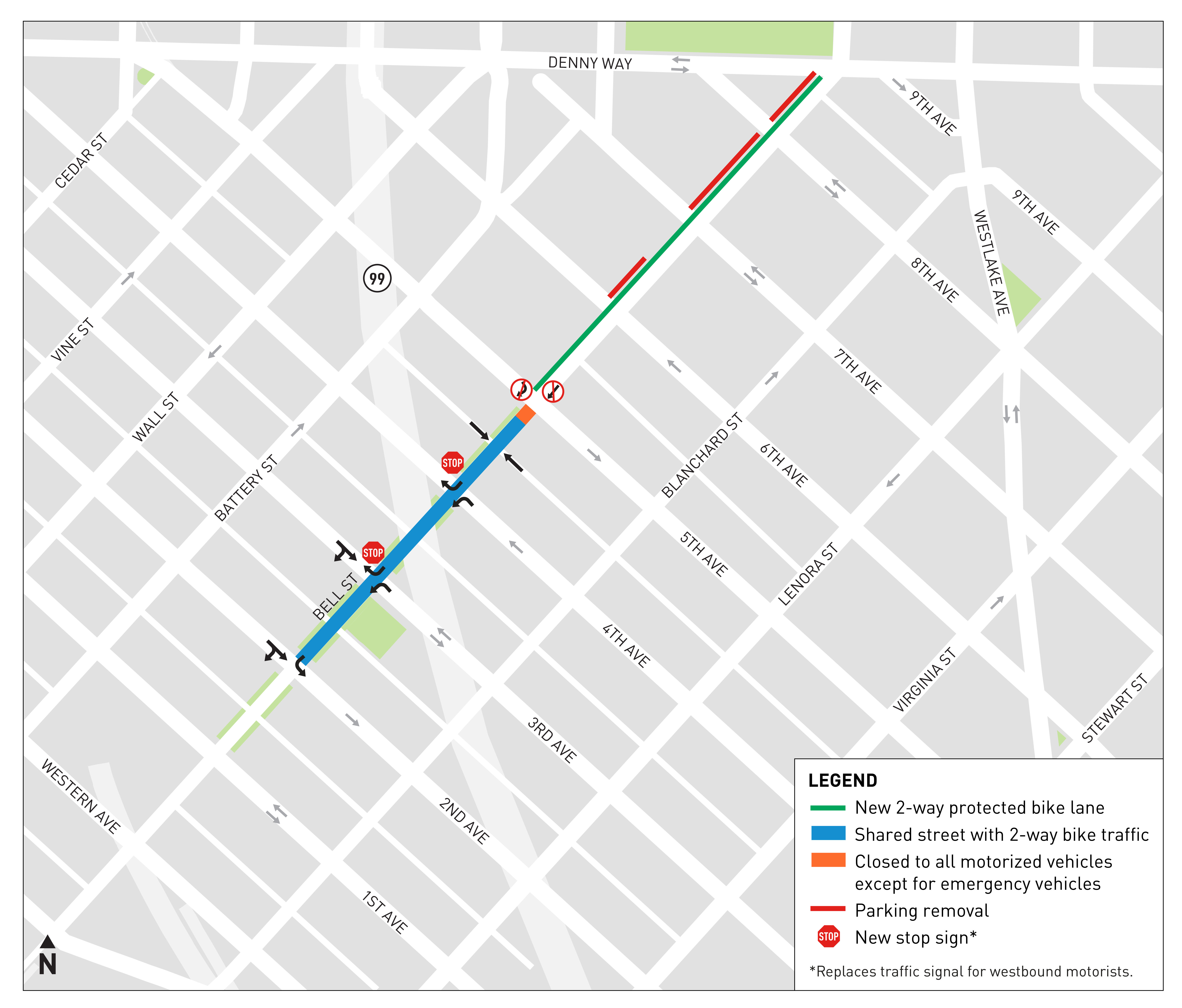
    The city just competed new bike lanes on Pike Street between 9th Ave and Broadway, that latter of which has a protected bike lane already. There is still a very tough gap between 6th and 9th Avenues, so effectiveness of the lanes will be held back until that is completed. But the sections that have been finished demonstrate the potential of safe and comfortable bike lanes in this corridor, and that’s exactly why community members have been working so hard to make sure they become reality. (more…)

    — Advertisement —
  • SDOT outlines Bell St bike route plans due to open in summer 2020

    Map of the Bell Street bike route plan, showing protected bike lanes between Denny Way and 5th Ave, and two-way biking between 2nd and 5th. It also shows new traffic controls at intersections for drivers.Bell Street has been a major westbound bike route through the Denny Triangle and Belltown for a long time. As the most obvious relatively low-traffic connection between 7th and 2nd Avenues for people biking southbound into downtown, Bell is a major connection in the Basic Bike Network.

    So it is great news that SDOT has announced a date to complete construction on a new bike route on Bell between 2nd Ave and Denny Way: Summer 2020.

    A four-block section of Bell Street was completely remade in 2014 into a city park, though one that still allows car travel. The curbs were removed and turned into clever street furniture, creating a street that feels more like a place to hang out. And it mostly works that way. Belltown needed more public park space, and using this street space to create a park was fairly inventive.

    But it is not car-free, and car traffic can still be heavy enough at times to make it feel more like a street than a park (thus it is sometimes referred to as the “Bell Street Park For Cars”). People are not supposed to drive more than a block through the park, allowing people to access alleyways and park. Signs at each intersection show turning arrows only (except transit and bikes). But people ignore this rule all the time, which really holds the park back from being as cool as it could be. A street that should be very slow and low-stress can still feel stressful when someone driving is using it as a cut-through.

    But while Bell has no bike lanes, at least it is better than its eastbound counterpart Blanchard. Traffic is a bit heavier on Blanchard, though it is not as heavy as many other downtown streets. But it is far from an all-ages-and-abilities bike route.

    That’s where the Bell Street project comes in. By making improvements to the park and creating a new two-way bike lane between 5th Avenue and Denny Way, the city will both improve westbound biking on Bell and create a new eastbound bike route option. And since Bell Street turns into 9th Ave N north of Denny Way, these new bike routes will connect to planned protected bike lanes on 9th. And 9th connects to the Westlake Bikeway, and … hey, this is starting to sound like a fully connected bike route! (more…)

    — Advertisement —
  • This is your final week to cross the Fairview Ave N bridge until 2021

    Map of the detour routes, showing a biking, walking and transit detour via Aloha Street.The Fairview Ave N Bridge connecting South Lake Union to Eastlake will close for 18 months Monday.

    As we reported previously, the biking, walking and transit detour will be routed via Eastlake Ave and Aloha Street. People driving southbound will be directed to continue south on Eastlake Ave to Stewart Street or any of the many streets into South Lake Union along the way. Northbound, people headed to Eastlake will be directed out of downtown via Howell Street.

    This is hillier than the current bridge option, for sure. But the real effectiveness of the bike detour will come down to whether they can maintain low and slow car traffic levels on the street. The plan notes Aloha as “local traffic only,” but will many people just drive there anyway? And given how many jobs are located in the area, there may be quite a bit of “local traffic.” I guess we’ll find out Monday.

    Additionally, the car detour could make Eastlake Ave more stressful for people who currently bike that route. So even if you don’t use the bridge, this change may affect your route. So just be prepared and give yourself a little extra time starting Monday.

    In our previous post, we also discussed some options for avoiding the area entirely. (more…)

    — Advertisement —
  • Watch: Biking Expedia’s amazing Elliott Bay Trail remake

    Expedia is preparing to start moving from Bellevue into their new campus on the Seattle waterfront starting as soon as next year. And work is very clearly in high gear across their huge new space.

    For the past year, the Elliott Bay Trail has been detoured around the campus work zone while crews went to work on a project to rebuild and significantly expand the trail and nearby park area where Smith Cove meets the bay.

    And, yeah. It’s pretty great. Check it out in the video above.

    For folks heading southbound, the Elliott Bay Trail has just meandered through a very industrial stretch of Interbay next to busy rail lines. Then the trail takes you past Smith Cove and the cruise ship terminal, and you start to get your first glimpses of the bay.

    Google Street View image from 2009 shows the sharp curve in the old path.
    From Google Street View, 2009.

    Previously, the trail made a sharp turn just as the bay and downtown Seattle came into view. This was kind of cool, but also a bit cramped and unnerving. Your attention was sort of pulled in two directions: Check out that amazing view, and make sure you don’t run into anyone behind the blind curve.

    Now, the space is much more wide open with a wide, gradually-curving trail. There’s also a terraced little hill you can climb up and just sit for a while and enjoy one of the best views in the city.

    View from the top of the terraced hill in the new park, looking toward downtown. (more…)

    — Advertisement —
  • Watch: The Path Less Pedaled visits Seattle (4 videos)

    Russ and Laura from the wonderful bike adventuring YouTube channel the Path Less Pedaled were in town recently and made four videos documenting their time. And they are all great, of course.

    First, they toured R&E Cycles in the U District/Ravenna and the legendary Rodriguez Cycles manufacturing area in the basement.

    Then they joined a Swift Industries community bike ride:

    And Russ did a solo adventure on the ferry to “Painbridge” Island trying to follow the grueling Chilly Hilly route.

    And after someone stole Russ’s bike tools from his frame bag (bummer), he biked to Counterbalance Bicycles near U Village and Free Range Cycles in Fremont to buy replacements.

    Our city really does have some incredible bike shops.

    — Advertisement —
  • 520 construction in Montlake will close cross-lake trail Sat and Sun, 24th Ave bridge until late this year

    Map of weekend construction showing closes off-ramps and the closed trail in Montlake.
    11 p.m. Friday through 5 a.m. Monday morning

    The 520 Bridge replacement project’s final set of projects kicks into high gear this weekend with a set of major closures in Montlake, including the 520 Bridge Trail and the 24th Ave E bridge.

    To make matters worse, the ramp closures mean no westbound bus access to Montlake. So you might not even able to put your bike on the front of a bus on the Eastside and expect to get off at Montlake (there will be some access on Saturday for the Husky football game).

    The 520 Bridge Trail is scheduled to reopen by 5 a.m. Monday morning to serve the morning commute.

    24th Ave E bridge is closed to biking and walking for good

    Map of the biking and walking detour for users of the 24th Ave E Bridge. The route goes via the Montlake Blvd east sidewalk.
    Starting Monday, trail users will connect to the east sidewalk of Montlake Boulevard if headed south.

    (more…)

    — Advertisement —
— Advertisement —

Join the Seattle Bike Blog Supporters

As a supporter, you help power independent bike news in the Seattle area. Please consider supporting the site financially starting at $5 per month:

Latest stories

— Advertisements —

Latest on Mastodon

Loading Mastodon feed…