This post is not about the couple of battery explosions reported in Seattle recently, but it’s hard to ignore that very visible (and rare) problem. This post is about recent pricing and service area changes by bike (Lime and Jump) and car (Car2Go and the now-defunct ReachNow) share services in Seattle, signs of trouble for the app taxi services (Lyft and Uber), and what Seattle and other cities need to start thinking about for the next phase.
I don’t have any answers. Instead, I want this post the be a place to collect your thoughts as users and to get folks thinking about the role of local governments in the future of shared mobility. Primarily, this site is focused on what comes next for bike share, though it seems worthwhile to consider the bikes within the context of the car-based services. I also want to restart conversations about public funding for bike share, which has proven to be incredibly valuable and effective at increasing the number of trips around town by bike.
But first, lets talk briefly about how we got where we are, what’s working and what isn’t. (more…)
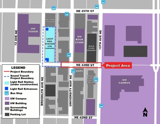
U District Station is going to change everything about the neighborhood when it begins operating in 2021, and the streets should reflect that. Located at Brooklyn Ave and NE 43rd Street, the main station entrance should be supported by streets that reflect the walking, biking and transit focus needed to help it succeed and thrive.
Today, NE 43rd Street dead ends into the station construction site halfway between the Ave and Brooklyn. The street also dead ends into UW Campus at 15th Ave NE. So it is not a necessary street for car movement, making it a great candidate to go car-free. Unfortunately, concepts floating around shy away from going fully car-free, which is a shame.
One big goal needs to be increasing the walking space to accommodate the more than 20,000 daily riders expected. Another goal, of course, is bike access. Bus access is a bit up in the air because it’s not fully clear whether buses will need to operate on the street or if they would be better serving the station via Brooklyn. However, plans seem to assume westbound bus operations complete with new trolly wires for the re-routed bus routes.
The U District Mobility Group and SDOT have two different concepts at this point, and the UDMG is currently taking feedback via an online survey.
Both concepts significantly widen the walking spaces, and both have potential. But the devil is in the details for both of them. So I’d like to hear from you all in the comments below.
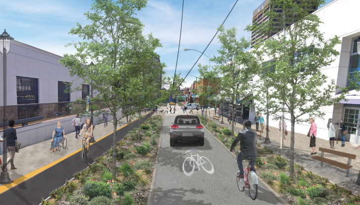
SDOT’s counter-flow bike lane
SDOT’s design definitely looks a little strange at first. It has a protected bike lane eastbound, but the single westbound lane would be shared by people biking, buses and even … cars? Well, this is where the details become important. The SDOT design would allow all vehicles on the one block between 15th and the Ave, switching to transit and bikes only west of the Ave.
How will the city prevent illegal driving west of the Ave? This question is vital. As we have seen with the Bell St “park” in Belltown, signage alone will not be enough to prevent people from driving there. And if this street gets clogged with cars, the bike access, transit efficiency and walkability goals will be hurt. But if they have a physical car diverter plan, then this option could work.
If planners decide against serious, physical traffic diversion, then they should build bike lanes in both directions. And there also needs to be space for people biking to safely pass buses at bus stops or this shared lane concept won’t really work as a bike route.
The city describes their design as curbless, so you could imagine it as Bell Street, but with a separated counter-flow bike lane.
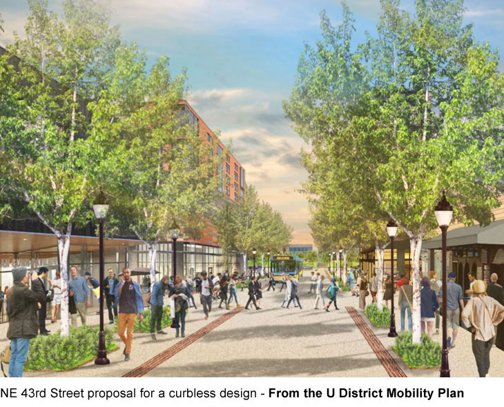
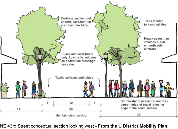
U District Mobility Plan’s wider curbless concept
Facing east.
The U District Mobility Plan concept looks a lot like the Bell Street “park” in Belltown and gets rid of the bike lane. It’s a curbless street, and road edges are marked by tactile strips for accessibility. The concept would be open to transit, biking and “local traffic.” Hmm.
As we’ve learned from Bell Street, this design works really well when there are no cars, but falls apart once people start ignoring the signs banning through car traffic. And since there will be significant demand for pick-up and drop-off at the light rail station, this street concept would fall apart if it becomes clogged with cars. And simply posting signs will not work. Physical car diverters are needed, which is a challenge when you are trying to allow buses.
But if car traffic is removed or severely limited, then no bike lane would be necessary. The benefits of a curbless street is that people can take over the space. Sidewalks can spill into the road, which is a good thing. You can imagine cafe seating and street festivals and all kinds of cool stuff here. But it has to be done right or cars will just fill the whole space like they always do.
This concept is also set up better for going car-free, which should be the goal for this street, especially for the blocks adjacent to the station.
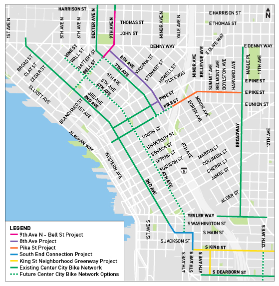
Seeing Queen Anne Greenways’ Mark Ostrow give Mayor Jenny Durkan a high five from his bicycle is the image that sticks in my head from Wednesday’s press event celebrating the opening of the 8th Ave bike lane downtown (Crosscut’s Josh Cohen captured the moment on video).
The real news is that Mayor Durkan is celebrating and promoting a bike project, a shift from her stance for most of her term as mayor. Not only that, but she acknowledged during her speech that bike projects have been delayed further than they should have.
“We know when we hit our reset, we didn’t reset quickly enough,” she said, according to the Urbanist.
This one press event will not heal relations with bike and safe streets advocates, and it also will not put the delayed bike plan back on pace. But it feels like an olive branch, and advocates from Cascade and Seattle Neighborhood Greenways took it (an olive branch on Olive Street! Coincidence?).
I hope this is the start of a change. She clearly took advice from the wrong people when she chose to cancel the designed, funded and contracted bike lanes on 35th Ave NE, and that decision has turned out to be a huge mistake. So I hope mending relationships with safe streets advocates also means she may seek advice from them in the future. (more…)
Daniel Ahrendt was biking westbound on Jackson Street in May 2015 when he crossed the very wide five-way intersection with Rainier, Boren and 14th Avenues. A bus was stopped next to the curb, so he changed lanes to pass. That’s when everything went horribly wrong. The track grabbed his bike wheel, sending him crashing to the ground. Then the bus pulled away from the curb and ran over him, crushing his pelvis and leg. He nearly died of blood loss, but medics and the trauma team at Harborview were able to save his life. He was hospitalized for a month.
That was May 2015, and he just recently settled with the city for $1.55 million. He no longer bikes and now lives in New York, the Seattle Times reports.
“I learned through my attorney that nine other similar bicycle/rail gap accidents had occurred where bicyclists fell due to the First Hill Streetcar tracks before my crash,” he wrote in a statement. “Seven accidents had occurred after my crash. I hoped that my lawsuit would help prevent additional, similar bicycle accidents.”
His crash was nightmarish, but it was also preventable. Before building the First Hill Streetcar line, it was already well known that streetcar tracks are dangerous for people biking because the gap is wide enough to grab all but the widest bicycle tires. And once your wheel starts to slip into the track, you don’t stand a chance. Seattle and Sound Transit learned lessons from the dangerous design of the South Lake Union streetcar, especially on Westlake. That’s why the First Hill Streetcar runs next to a protected bike lane on Broadway.
But they did not continue this protected bike lane for the rest of the route, including heavily-biked Jackson Street. This was a huge mistake, and people continue to get injured.
As is common in settlements like this, the city did not officially admit fault. But something needs to happen to improve safety along our streetcar routes, including Jackson Street, Yesler Way and in various parts of South Lake Union. And experience from around the world shows that the only complete solution is to have separated bike lanes that cross streetcar tracks at safe angles as close to 90 degrees as possible.
Seattle City Attorney Pete Holmes has a truly despicable quote in the Seattle Times, basically telling everyone who has been injured (or killed) after their bike wheels got caught in the streetcar tracks that it was their fault. (more…)
UPDATE 8/20: SDOT says the closure could start at early as September 16.
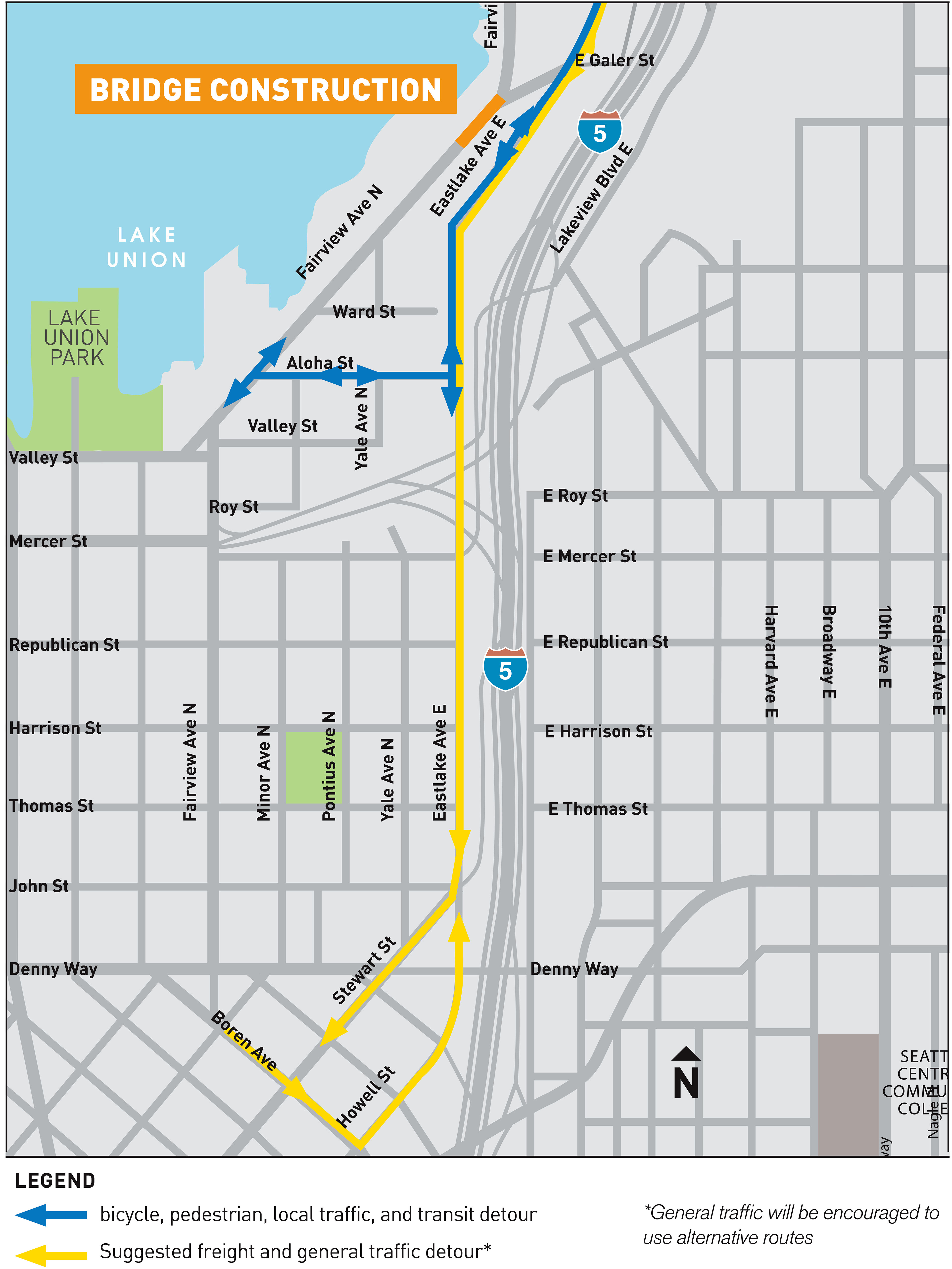
If you bike along the east side of Lake Union into the city center, then you should get ready for a significant change to your bike route later this year.
Work has already started to prepare for the Fairview Ave N bridge replacement, but the extended closure of the bridge will cut off the only flat bike route between Eastlake and South Lake Union/downtown for more than a year. So it’s not a bad idea to start trying out some alternate options to see what works best for you.
You may not fully realize you are on a bridge when you cross over the Fairview Ave N bridge. But if you walk along the floating path to the north of the bridge, you can see that the roadway is supported by aging timber that doesn’t inspire a ton of confidence. The structure does not meet seismic standards, and it is the final timber-supported major bridge left in the city. Replacing it was a key project in the Move Seattle Levy, which voters approved in 2015.
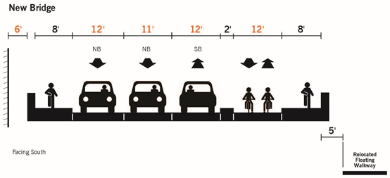
The full bridge is scheduled to close for construction in the Fall and won’t reopen until 2021. Exact dates are not yet listed on the project webpage. The new bridge will have a two-way bike lane and a sidewalk on the north side of the bridge:
Work is underway right now to build elements of the Aloha Street walking/biking/transit detour. This will probably be the best option for most people, though it does include some significant climbing. A new traffic signal at Aloha and Eastlake should help people heading north make that left turn onto Eastlake.
One big question is how well the paint-only bike lanes on Eastlake Ave will hold up under the expected increase in traffic.