— Advertisement —
  • Ian MacKay is making his second cross-WA bike tour on his sip-and-puff wheelchair

    On of Ian’s riding partners helps him cool down on a long hot road. Photo from Ian’s blog.

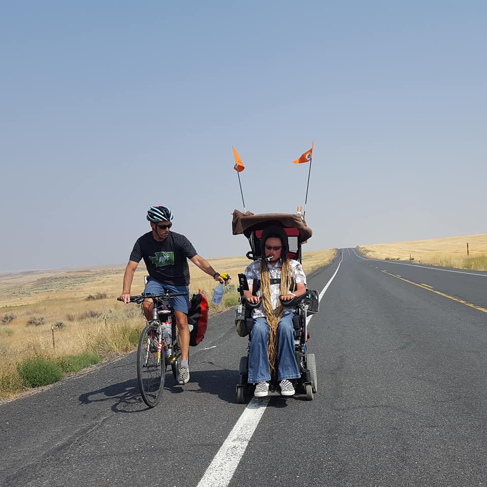
    Ian MacKay is on a 7 MPH bike tour across Washington State for the second time. As of press time, he and his riding partners are a day’s journey beyond the Grand Coulee Dam heading west on their trip from Spokane to his home near Port Angeles.

    MacKay’s ride is an electric wheelchair he controls using sip-and-puff controls. It’s decked out this year with new lithium batteries that can keep him moving at his top speed for the 40 miles a day he hopes to cover during his two-week adventure. He is documenting his journey on a blog and via social media (Twitter, Facebook, Instagram), and he has been capturing the imagination of the local news everywhere he goes.

    Ian was injured in a California bike crash in 2008 that paralyzed him from the neck down. While recovering he started exploring further and further from home along the Olympic Discovery Trail, a paved rail trail connecting Port Angeles to Discovery Bay. That’s how he got the idea for his first cross-Washington trip in 2016.

    He gave an incredible keynote talk at the 2017 WA Bike Summit about his adventure, and I highly recommend setting aside a half hour to watch the whole thing:

    (more…)

    — Advertisement —
  • Wilson Ave S bike lanes will fill key gap in SE Seattle, meeting Thursday

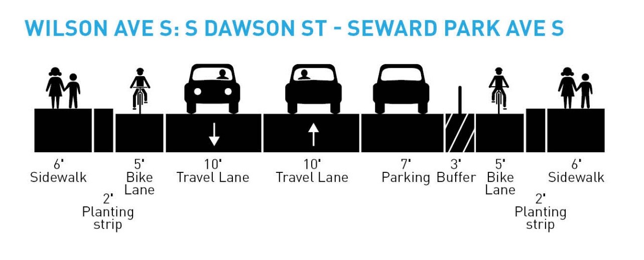
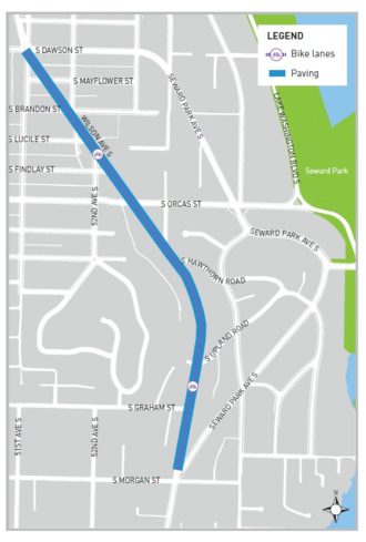
    Wilson Ave S is a true rarity in the hilly neighborhood above Seward Park: It is relatively flat and direct.

    Well, OK, the whole street isn’t flat. But the 0.8 miles of the street that the Seattle Department of Transportation is repaving this year are surprisingly flat, connecting the very popular Lake Washington Loop bike route to the business district at S Dawson Street (Third Place Books) and the existing painted bike lanes on 50th Ave S that connect to the bike lanes on S Genesee St into Columbia City.

    Workers have already started work to repave this stretch, and plans call for a northbound bike lane protected by parked cars and a southbound painted bike lane as well as new curb ramps all along the route. This meets the criteria in the Bicycle Master Plan, which calls for “in-street, minor separation” bike lanes here. In fact, this is one of the few new protected bike lanes planned in all of SE Seattle.

    Though it is quite rare for designs to change once construction has begun, SDOT is holding a public meeting to get feedback about a change in the parking plan Thursday. People who bike are encouraged to attend to weigh in, but the proposed changes still include bike lanes. Details from the project page:

    You’re probably wondering, “what’s up with the protected bike lane?” Well, we hope you will join us on Thursday, August 16 from 6 to 8 PM at the Lakewood Seward Park Community Club for a public meeting. We will be sharing an updated design for the planned protected bike lane. We heard the community’s concerns about the protected bike lanes and pedestrian and neighborhood safety.

    (more…)

    — Advertisement —
  • Lime’s expanded discount program lets people pay in cash, unlock 5¢ bikes with a text

    A nickel. In 2018, there is essentially nothing that costs a nickel.

    But that’s all it costs for qualifying low-income users to unlock a Lime pedal bike under the company’s newly-expanded Lime Access program ($5 for 100 rides). And qualifying users (see #4 below) can also now pay in cash and unlock bikes using any mobile phone that can send text messages or make calls, allowing people who don’t have a bank account and smart phone with a data plan to use their bikes.

    Qualifying users can also access Lime’s e-bikes at half price (50 cents to unlock plus 7 cents per minute). So a half hour e-bike ride would cost about the same as bus fare ($2.60).

    To get set up, the Lime Access webpage tells users to email [email protected] the following:

    1. Full Name
    2. Phone Number (this number should be for the phone you plan to use for LimeBike)
    3. Valid government-issued photo ID
    4. Proof of low income status (e.g. EBT card, discounted utility bill, or any other state or federally-run assistance program document). Seattle Bike Blog has confirmed that an ORCA Lift card will also work.

    It will take Lime staff up to two days to get accounts verified and set up. Users will also need access to a printer if they don’t have a smart phone so they can print a unique barcode they can use to load money into their accounts at any ParNearMe location, including the 50 or so 7-Eleven and CVS stores in Seattle. (more…)

    — Advertisement —
  • West Seattle Link might destroy the Sodo Trail, but that could be a good thing

    The Sodo Trial in Bike Master Plan. The planned extension is marked “17.”

    SDOT has been planning an extension of the Sodo Trail to reach Spokane St under the West Seattle Bridge for a while now, but that work could take a major turn if Sound Transit chooses a West Seattle light rail alignment that displaces some or all of the existing trail.

    At this point, the project team is still proceeding with design for a trail along the busway and light rail tracks assuming Sound Transit projects won’t change the area, according to an SDOT staff update to the Seattle Bicycle Advisory Board.

    However, there is a chance that Sound Transit will decide to use the existing trail right of way. If that happens, design changes or even an entirely new route may be needed. The Board expressed the need for a connection, and SDOT Liason to the Board Serena Lehman said the department would work with Sound Transit to identify an alternative option if the trail is removed or impeded.

    And trading the Sodo Trail for a different nearby connection might not be such a bad thing.

    The Sodo Trail is a little oasis of low-stress biking surrounded by wide and often scary industrial streets. But access to the trail is awful from just about every direction. And the prospects for connecting bike routes to it are a bit difficult. It directly serves Sodo and Stadium Stations, but that’s really the only thing it does well. The connections to nearby businesses, the International District, West Seattle and Georgetown are all pretty rough.

    4th or 6th Ave S, on the other hand, have much more complete connections. They serve more destinations and workplaces than the trail and have great potential for connectivity at their north and south ends. (more…)

    — Advertisement —
  • Green Lake/Wallingford paving projects create opportunity to make huge bike improvements, comment by Wednesday

    Overview map of projects in the paving group. Images from SDOT.

    SDOT has grouped a bunch of Green Lake and Wallingford area paving projects together, designing and planning construction of them all at the same time. Because paving projects essentially wipe the street design clear, they are our best opportunities to build elements of the Bicycle Master Plan for little extra cost. The city can rehab existing infrastructure and improve safety using the same dollars.

    Though the projects in this group were chosen for paving purposes, many of them happen to lie along routes designated for bike improvements. And the city’s plans are so far mostly very strong, including a two-way protected bike lane around Green Lake, uphill bike lanes on N/NE 40th St and improved bike lanes on N 50th St where it passes under Aurora.

    You can learn more and weigh in on the projects through SDOT’s online open house. Responses are due Wednesday (tomorrow), so don’t procrastinate.

    The repaving group covers a total of six miles. And though the city’s plans are a good start, a neighborhood group calling themselves Green Lake and Wallingford Safe Streets has organized to push for even more ambitious options.

    Green Lake Way

    The biggest changes of all are coming to Green Lake Way between N 83rd Street and N 45th St. The messy intersection at the north end of the lake will get a redesign and a new traffic signal, and the current paint-only bike lanes around the east half of the park will become a new two-way protected bike lane on the park side of the street. These are major upgrades to a major bike route.

    The weirdest part of the whole plan is the transition from one-way bike lanes to the new two-way bike lane at N 52nd St. It would be cool if planners could find a way to do this transition at N 50th St instead, perhaps as part of a redesign of that awful intersection. The team currently does not plan any significant changes there, but they have heard loud and clear from basically everyone that they hate that intersection. It’s also worth noting that people walking have it the worst there, so a remake is very needed.

    Here’s a look at the planned Green Lake Way changes starting at N 83rd St (a major bike connection across Aurora to Greenwood) and moving south: (more…)

    — Advertisement —
  • Downtown-to-ID bike lane options are proving difficult, city plans subpar route

    The blue line shows the route SDOT is planning for the near-term bike connection to the ID and and beyond. Green and Orange lines are current or planned bike routes.

    Connecting the 2nd Ave bike lane to the International District and the Southeast Seattle bike routes beyond is proving to be very difficult.

    This connection is the single most important missing piece of the downtown bike network, and the City Council this week included it in the resolution listing projects they want SDOT to complete by the end of 2019. A connection to the International District not only brings that neighborhood into the downtown bike network, it also unlocks Beacon Hill, Rainier Valley and large swaths of the Central District and First Hill. It is also connects to the Mountains to Sound Trail leading to the Eastside and beyond.

    “The reality is that this route needs to exist if we want to connect to the southern half of the city,” said Clara Cantor of Seattle Neighborhood Greenways.

    But the extreme steepness of First Hill, missing street connections over the railroad lines near King Street Station and streetcar tracks in the middle of S Jackson Street create a pinch point where the bikeable route options overlap with bus routes that are about to get a hell of a lot busier when buses get kicked out of the tunnel.

    After exploring a lot of options, SDOT has picked a route that bike network advocates including Seattle Neighborhood Greenways have not supported. But SDOT staff says it is the only route feasible in the near term.

    The city’s plan includes bike lanes on Main Street from 2nd to 6th Avenues, then on 6th Avenue to Dearborn. SDOT staff presented the concept, which is still in draft form, during Wednesday’s Bicycle Advisory Board meeting.

    The benefits of the route are that it is legible (other options included more twists and turns), it mostly avoids the First Hill Streetcar tracks and it avoids conflicts with major bus stops on Jackson and 5th Ave.

    The downside is that the block of 6th Ave between Jackson and Main is a very steep 11 percent grade, climbing about 30 feet in just one block. It may be so steep that many people will avoid using it, which would defeat the purpose. (more…)

    — Advertisement —
— Advertisement —

Join the Seattle Bike Blog Supporters

As a supporter, you help power independent bike news in the Seattle area. Please consider supporting the site financially starting at $5 per month:

Latest stories

— Advertisements —

Latest on Mastodon

Loading Mastodon feed…