Whether you are broken down on the side of the road or just need to get your bike to the shop for a tune-up, Speedy’s will have an electric van ready to head your way and transport your ride to your preferred bike shop.
(Full disclosure: Speedy’s advertises on Seattle Bike Blog, but this post is not sponsored. Seattle Bike Blog does not publish sponsored posts)
Founder Tyler Swartz got the idea for Speedy’s after both he and his brother encountered the same issue with their e-bikes.
“My brother had an e-bike in Miami, and he had a lot of trouble getting it into his car,” he said. “I ran into the same issue with my big cargo bike.” E-bikes and cargo bikes be difficult to transport by car or even SUV if the need arises, and that’s assuming you even own a vehicle in the first place. The service could also be useful for anyone who has trouble lifting and carrying these heavier bikes if the need arises.
“Everyone wants to make it more enjoyable to own a bike and operate a bike, so we’re just trying to figure out a way to remove some of those painful errands and burdens you have with a bike,” said Swartz, who launched the business in February.
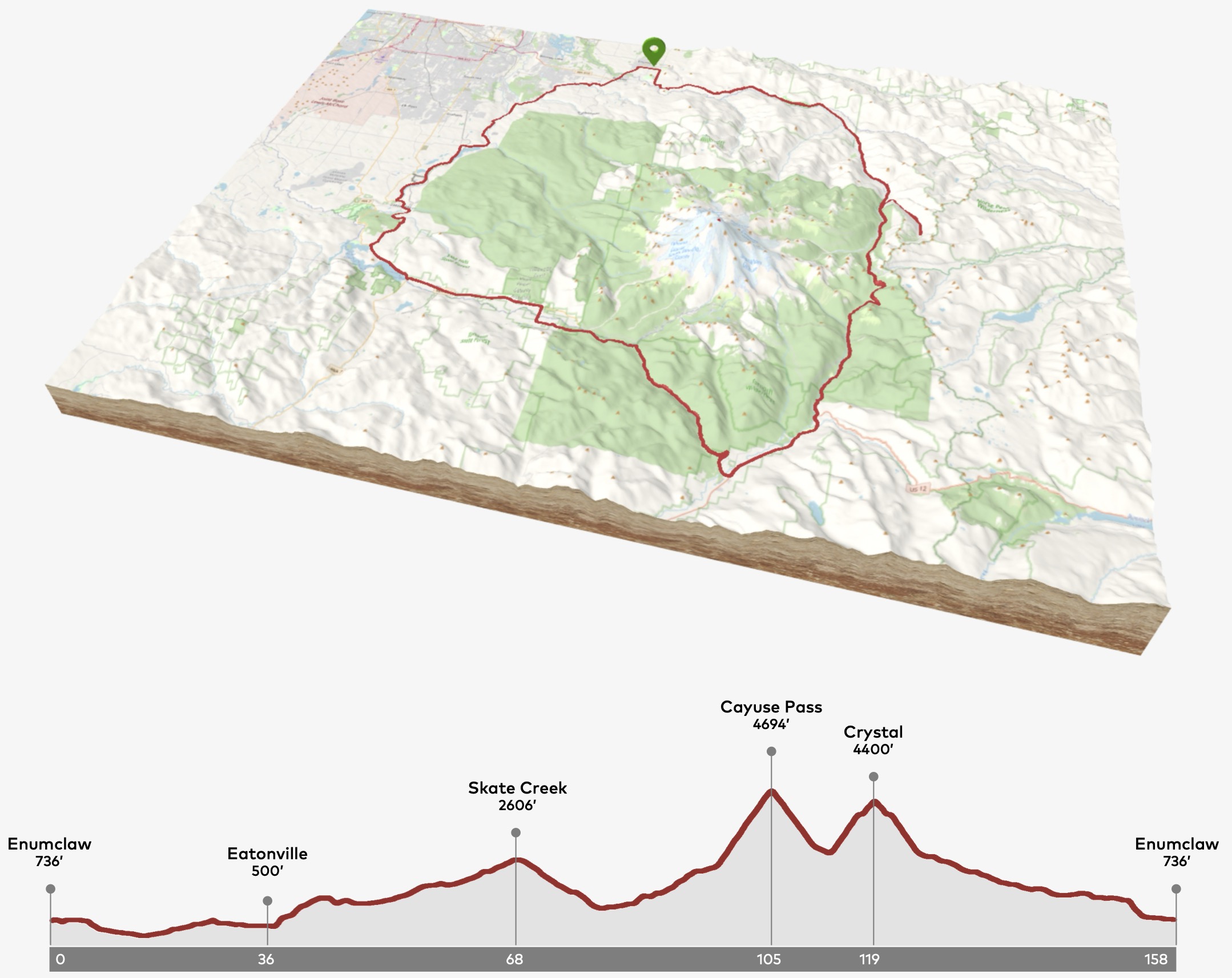
It’s one of the most difficult and beautiful one-day bike rides you’ll find anywhere on earth, and hundreds of people have been taking on the challenge every summer (except 2020) since 1984. The Ride Around Mount Rainier in One Day (“RAMROD”) is 150 miles long and includes 10,000 feet of climbing, but that grueling physical feat takes place on roads both within and outside the bounds of Mount Rainier National Park.
But the event’s 40th anniversary is in peril after the National Park Service denied access to roads within the southern part of the park, effectively cancelling the 2024 ride. Organizers at the Redmond Cycling Club said that the NPS decided RAMROD was no longer a “necessary and appropriate use.” The Club says they have attempted to “collaboratively understand the underlying issue and address concerns,” but have so far been unsuccessful.
The route begins and ends in Enumclaw, and roads remain open to traffic during the ride. As a road cycling event, RAMROD does not use off-road trails, where cycling is typically banned within the park. Specifically, the NPS has rejected access to the beautiful and remote Paradise and Stevens Canyon Roads, and the ride can’t feasibly exist without them. I have reached out to Mount Rainier National Park to ask why they denied access and will update when I hear back.
The club is not giving up, though. They have started an effort to engage Washington State’s elected federal officials in hopes that they can help bring NPS to the table to find a solution that allows the event to continue. The club is asking people to contact Senator Patty Murray, Representative Kim Schrier and Mount Rainier National Park to voice support for the ride and encourage a solution that keeps the iconic tradition going. They are also “keeping the leadership team active for the possibility that the Park reverses their decision and enough time remains to allow us and cyclists to prepare properly,” according to their website. The latest they could start registrations with enough time to properly organize the summertime event is April, the club said. Action will need to come fast to save the 2024 event.
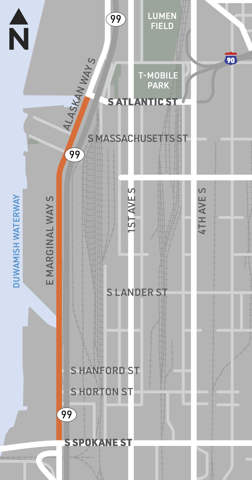
Construction crews are preparing to begin work on a major, multi-year rebuild of E Marginal Way S as soon as March 11, according to SDOT. The project includes building an entirely new roadbed built to withstand heavy truck traffic as well as new protected bike lanes. Work is not expected to be complete until 2026.
Walking and biking access will be maintained throughout the multi-year project, which is good news because there is no viable alternative land route between the Spokane Street Bridge and downtown Seattle. The exact route will move around and change as the work zone changes.
The project will rebuild E Marginal between S Spokane Street (West Seattle Bridge) and S Atlantic Street (start of the Alaskan Way Trail), passing by several major Port of Seattle access points. I addition to maintaining walking and biking access, the project will also maintain freight-only access to these major Port driveways. General purpose traffic will be detoured to 1st Ave S as necessary.
When the street finally opens, it will likely be the final piece of a complete and connected Seattle Waterfront Trail (not its official name) that links the Alki and Duwamish Trails through SoDo and downtown to the Elliott Bay Trail in Myrtle Edwards Park and beyond.
The project recently overcame a complicated railroad ownership hurdle and is finally ready to start. SDOT has secured more than $38 million to build the project, $20 million of which is from a federal RAISE grant, $5 million from the Port and the rest from the Move Seattle Levy and state funding.
Below is a more detailed look at the final design:
The winter-time ride is renown and even celebrated for its unpredictable weather, and while turnout of typically good in rain (or like last year, snow), the numbers can balloon if the sky happens to be clear. It wasn’t exactly clear last weekend, but close enough. More than 2,000 people rode this year, and anyone starting on the east side of Elliott Bay began with an iconic bike-filled ferry ride. As Yeung (who is a recent addition to the Cascade board) says in the video, “It’s sort of like if you entered into an upside-down world where everyone commutes by bikes, and we fill these boats and ferries with people and their two wheels.”
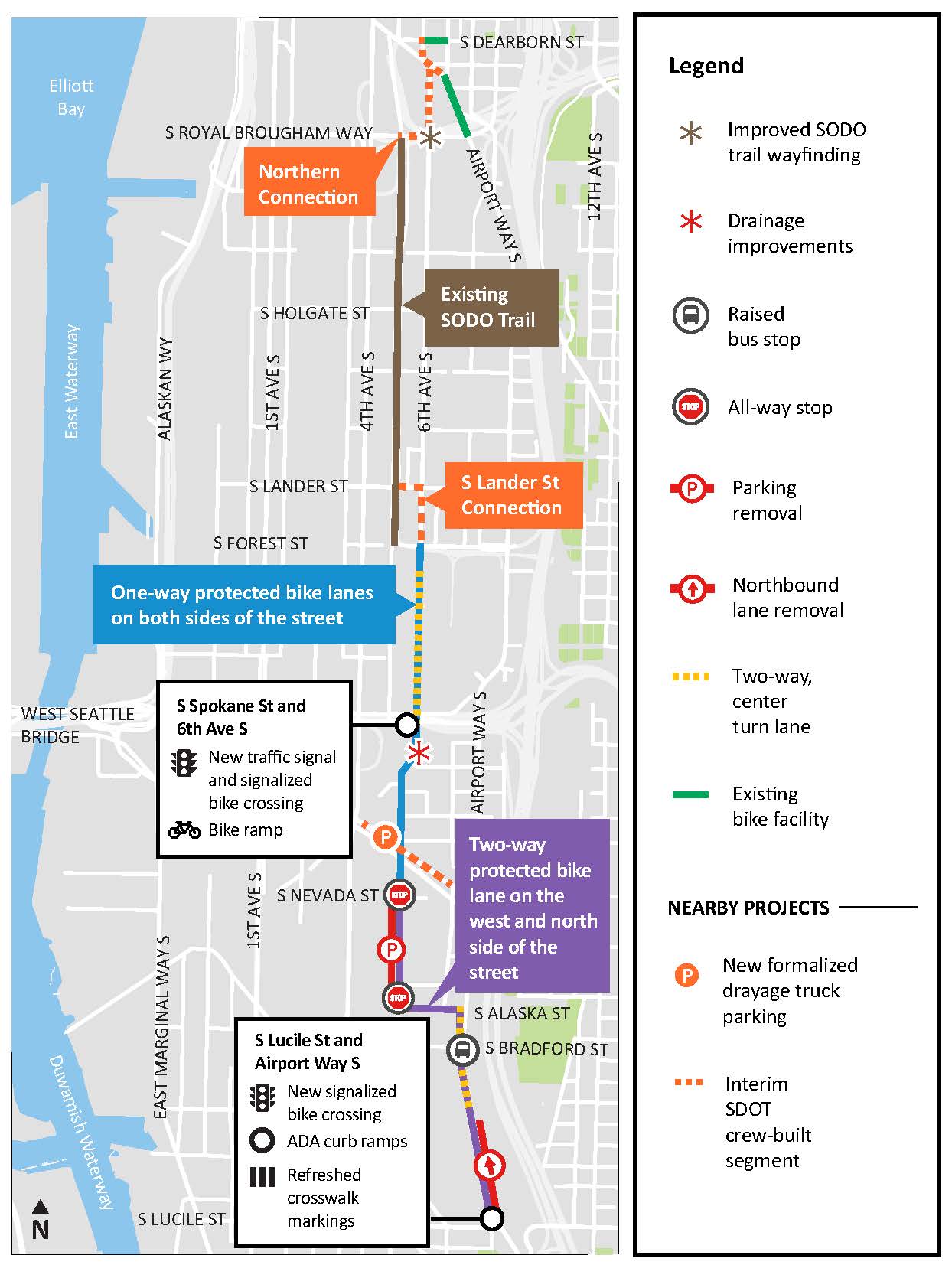
A project to finally connect across one of the worst bike network gaps in Seattle should begin construction in the summer. The Georgetown to Downtown Safety Project will build missing bike lane sections to the north and south of the SoDo Trail, connecting the International District to Georgetown. The plans are final, and the city will try to find a contractor in the spring that can start work in the summer. Work is expected to wrap up in 2025, though a more specific construction schedule won’t be available until the contractor is selected and is ready to begin.
The Georgetown to downtown project is just one of three South Seattle safety project designs that SDOT recently completed, along with bike lanes on Beacon Hill and a Georgetown to South Park route. 2025 will be a big year for opening new bike connections.
The project is broken up into two main sections: North of the SoDo Trail and south of the SoDo Trail. The SoDo Trail runs adjacent to the light rail tracks between S Royal Brougham Way (Stadium Station) and S Forest Street, and it is a lovely ride lined with large murals painted on the sides of warehouses and other industrial facilities. But connections at both ends are sorely lacking, dropping people into wide industrial roads with little to no guidance or protection.
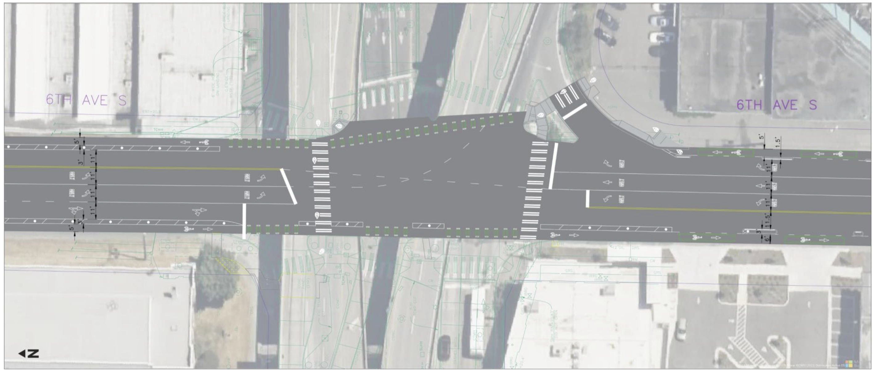
Completing the north connections is surprisingly simple, though it is really more of a mid-term solution because the area seems poised for a major redevelopment of some kind in the not-too-distant future. The connection hinges on the city and King County modifying their permit arrangement along 6th Ave S to either open the street entirely or allow a biking and walking path. A shelter opened along the street first as a Covid response facility and then as a place for people experiencing homelessness in 2020, and the street has been fully closed ever since. This complete closure, created in response to duel emergencies, was a bit short-sighted because 6th Ave S was an important biking and walking route that allowed people to skip a section of busy and fast Airport Way S. The plan essentially routes people to the north sidewalk on Royal Brougham Way for a block, then to a new path on 6th Ave S. SDOT crews will then install short sections of bike lanes on Seattle Blvd S to connect to 6th Ave S in the International District.
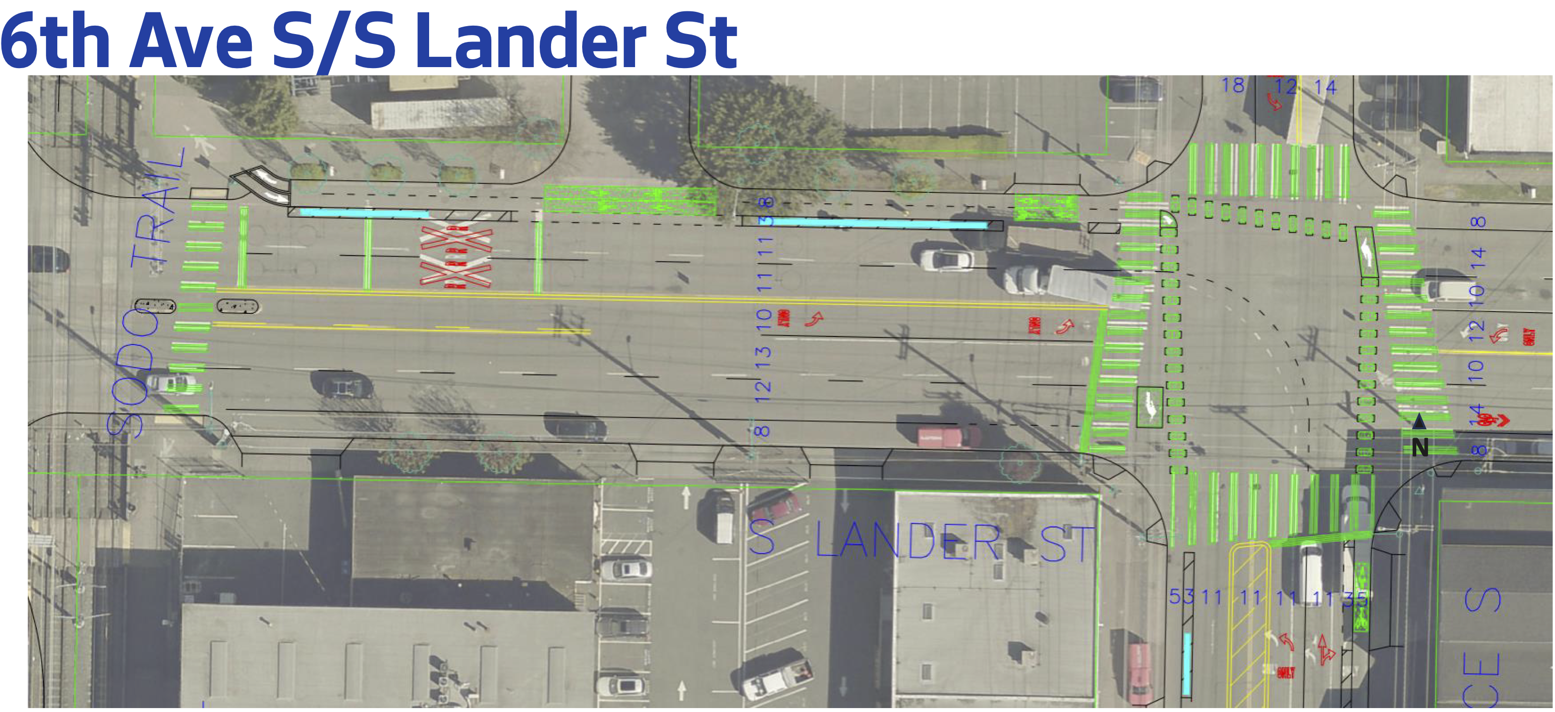
Images from the 90% design, though there have been few changes since.
The south section is much more complex. Starting from the SoDo Trail, riders will be directed to leave the trail a block early to access a two-way bike lane on the north side of S Lander Street. This bike lane will serve trail users as well as anyone heading across the Lander overpass, which routes people biking onto its wide north sidewalk. Riders will then need to transition to one-way bike lanes on 6th Ave S. This short section is being designed and delivered by SDOT rather than the contractor because they are still working out some details but didn’t want to hold up the rest of the project. The plan is to build this connection to open along with the rest of the project.
The bike lanes will continue on 6th Ave S all the way to S Alaska Street. The intersection with S Spokane Street is the most difficult spot. The northbound solution isn’t great, routing people onto the sidewalk to cross a freeway ramp, but it does include a new traffic signal to separate right-turning vehicles from people walking and biking in that crosswalk. The freeway ramp spaghetti in this location is really bad, and it is difficult to work around without a major-budget redesign of how it all works. Maybe they could have done better with the bike lane here, but there’s a lot of active pavement to cross. Hopefully they can use traffic signals to keep the bike lane and crosswalks as safe as possible, but this area is one to watch closely once it opens.
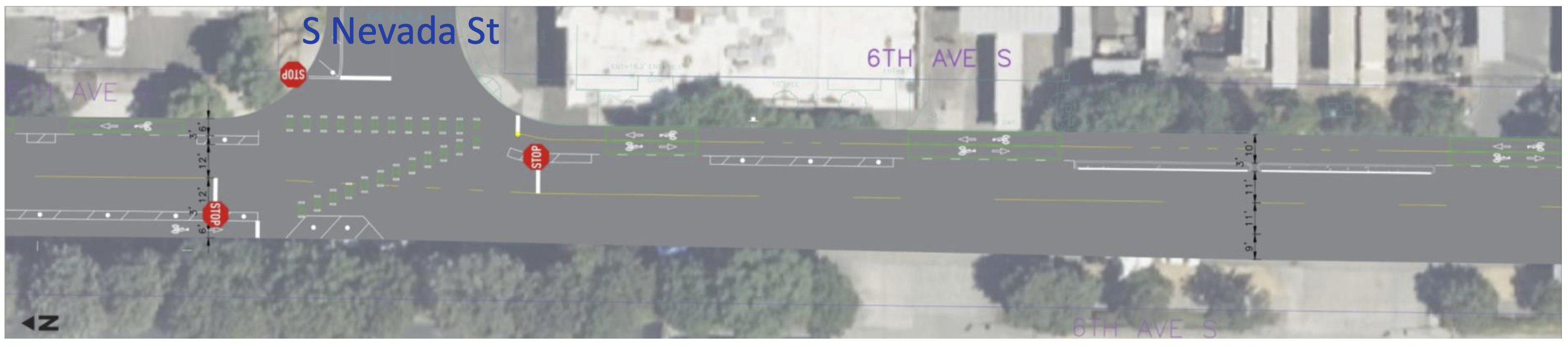
The bike lanes stay as one-way lanes until reaching S Nevada Street, where people will cross into a two-way bike lane on the east side of the street. This is a little funky, but it allows the bike route to avoid the very busy all-hours UPS distribution facility driveways, which seems like a worthwhile trade-off. The two-way lane will then turn and transition to the south side of S Alaska Street to connect to a two-way bike lane on Airport Way S, which has a rare bridge over the train yard. This will be the only north-south bridge over the train yard that has dedicated biking space.
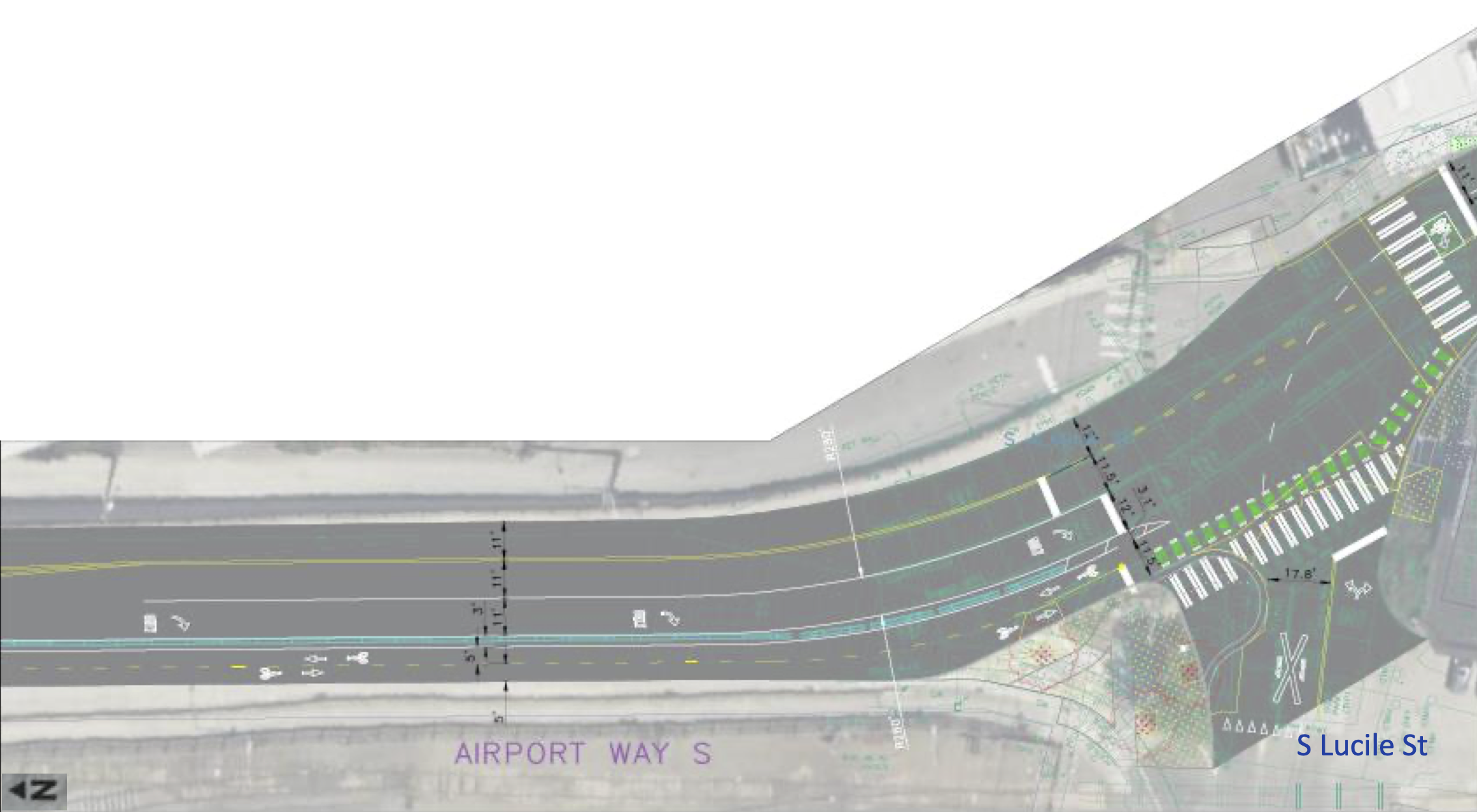
The bike lane over the bridge connects to S Lucile Street, which is getting a major new curb bulb that should dramatically improve the safety and comfort of the crosswalk there. The slip lane for right turns from the bridge onto Lucile will be closed, encouraging slower and safer turns at the intersection instead. Unfortunately, this is where the project ends. People will be let out into Georgetown, but connections within the neighborhood and to the Lucile Street Bridge one block further south will have to wait for a future project that is not yet designed or funded. Perhaps a Georgetown walking and biking circulation network of some kind could be prioritized in the early part of the city’s next transportation funding measure.
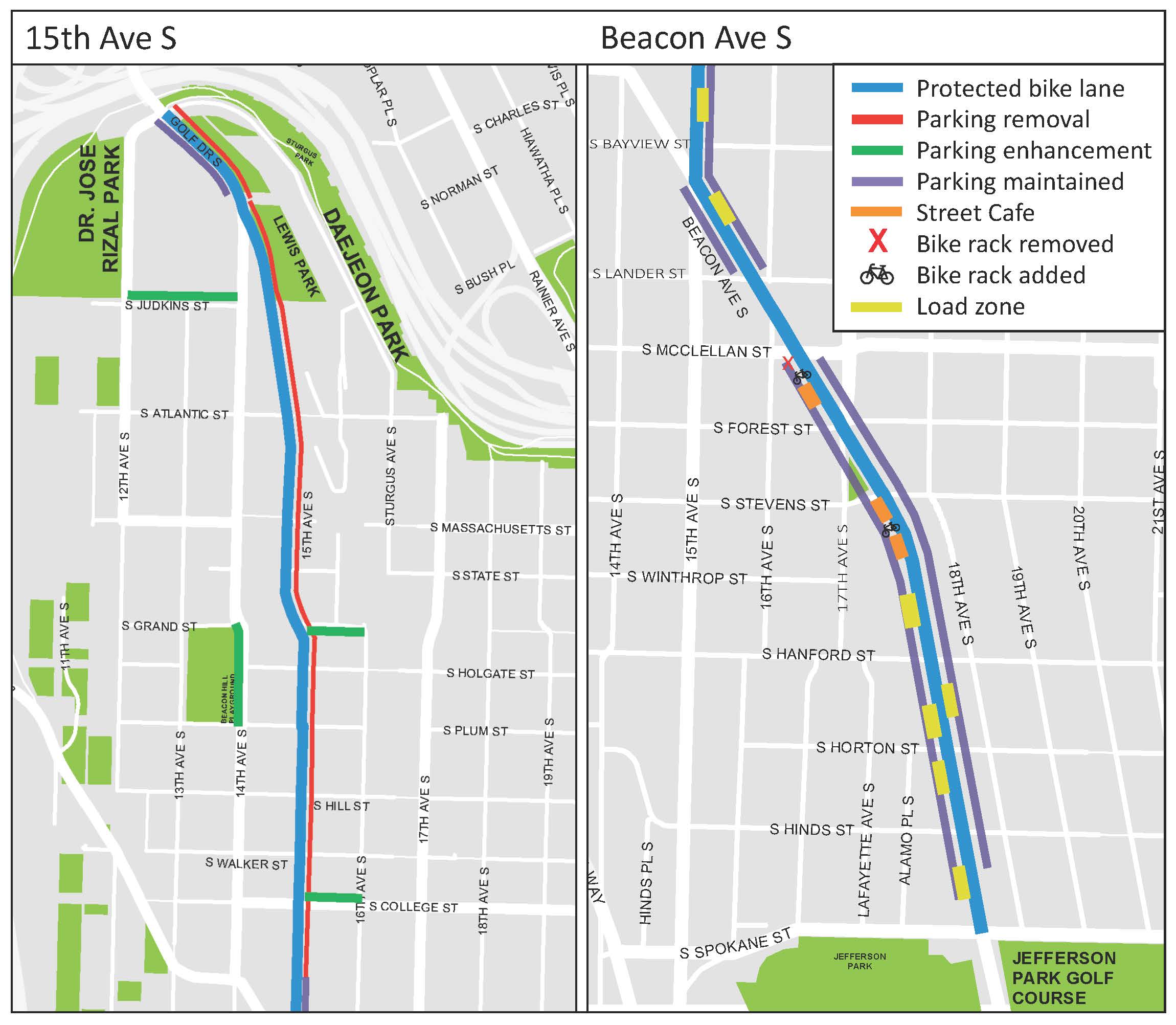
A project to build 1.5 miles of protected bike lanes from the José Rizal Bridge to Jefferson Park on Beacon Hill should begin construction this summer, SDOT announced. The department completed design for the project following years of public outreach and is preparing to advertise it to hire a contractor.
The project will finally add a protected bike facility through a neighborhood that has long relied on biking. Though it is hilly, as the name implies, Beacon Hill falls squarely into Seattle’s bike commute doughnut, the area just a bit too far from the downtown employment center for a quick and easy walk. North Beacon Hill homes are a 15–30 minute bike ride from center city jobs and destinations using the most direct routes, but those routes require mixing with busy car and bus traffic. So while North Beacon Hill has always had a good number of people who bike, connected and comfortable bike facilities will make biking more appealing and approachable for more people.
But even beyond biking, the planned design changes should bring significant safety improvements for everyone, including people crossing these 15th Ave S and Beacon Ave S on foot. The designs include 10-foot lanes for general traffic or 11-foot lanes for stretches where there are bus routes. Reducing lane widths calms traffic while also minimizing the time people using crosswalks are exposed to traffic. The design also includes curb bulbs and other crosswalk improvements.
The 15th Ave S section will remove a lot of existing on-street parking, but staff scoured the area to find additional blocks that could be used for parking. They are also planning to remove a short and disconnected section of paint-only bike lane on 14th Ave S to turn that into on-street parking. We argued in a previous post that this is a worthwhile trade-off, though some readers pushed back and said they use it to access the school and the park and are concerned about safety during Beacon Hill Elementary School pick-up and drop-off. Hopefully this is something SDOT is paying close attention to.
The most complicated part of the whole project is probably the intersection of 15th Ave S and Beacon Ave S. Not only is it at an angle, but it is also the busiest intersection. There is already a partial “scramble” walk phase in which all the crosswalks show “Walk” at the same time and no car movements are allowed, and this safety project will keep it. People biking will also be able to go straight or make any turning movements they need during this all-crosswalk phase, though they need to yield to people in crosswalks. People biking will also be able to go straight when the adjacent general traffic lights are green, though anyone trying to make a left turn after the all-crosswalk phase ends will need to use a left turn box as is common for many of the city’s bike lanes. The tricky part is communicating all this to people on bikes. The signal diagram in the plan appears to show the bike signal turning green whenever straight-traffic in the same direction is allowed as well as when the all-crosswalk phase is active. But how will someone biking know when it is too late in the all-crosswalk phase to start a left turn? Obviously, it would be bad for someone to start a long left turn at the same time that people in cars get their green lights. Also, does a green bike signal conflict with an all-crosswalk phase? A green bike signal tells people biking they have the right of way, so they would reasonably assume that any crosswalks in their path would be showing Don’t Walk. This is the first time Seattle has had to figure out how to add bike signals to this unique type of intersection. Does it require multiple sets of bike signals? Should the bike signal stay red during the all-crosswalk phase but be paired with a sign that says something like “🚲 May Use Ped Signal”? Or how about a flashing red or flashing yellow bike signal? Are those a thing? My kindergartner suggested rainbow lights that mean everyone should dance, which is at least worth considering. I asked SDOT staff during a recent press briefing how the signals will communicate when people biking can and cannot make left turns, and I will update when I hear back. Below is a technical plot from the 100% design showing the intersection and the signal phase diagram for anyone who wants to try to decipher it or come up with solutions: