— Advertisement —
  • Seattle Bike Blog is back! What did we miss?

    I left my laptop at home, but I brought my bike (of course)
    I left my laptop at home, but I brought my bike (of course)

    I’m back!

    After six years of reporting bike news, I took my first sabbatical from Seattle Bike Blog for the past three weeks. I left my laptop in my Central District home and did not buy an international data plan.

    No Twitter. No email alerts. No phone calls. No reading Seattle Times commenter bike hate. It was amazing.

    But I hear that even though I was not here, bike stuff continued to happen. So, what did I miss? What are the top issues you all want updates about? Help me out by commenting below.

    — Advertisement —
  • Gone Bikin’: 39th Ave NE greenway gets a refresh, speed humps

    IMG_2882.JPGSeattle Bike Blog Editor Tom Fucoloro has Gone Bikin’ until Labor Day. In the meantime, we will be periodically posting short news bits and excerpts from good reads floating around the web.

    The 39th Ave NE neighborhood greenway was among the city’s first good tries at such a facility, and it was mostly successful. But there are some things SDOT has learned since (like the importance of speed humps to keep through-traffic slow and discourage long drives along the route). So the good news is that the city is adding speed humps and stop signs along the route to bring the route closer to their current standards.

    Wedgwood Greenway Map v3Details from and SDOT mailer (PDF):

    The Wedgwood neighborhood greenway on 39th Ave NE opened in 2012 and was extended north of NE 80th St in 2014. In 2014, we evaluated the existing greenway, which met many of our current design guidelines, but lacked speed humps to encourage calm speeds. To determine if speed humps were needed car volumes and speeds were analyzed.

    WHAT WE LEARNED

    Traffic volumes along the route range from about 100 to 300 vehicles a day falling well below greenway design threshold of 1,500. The speed in which 85 percent of people are driving at—or below—is 25 to 27 miles per hour (mph). This is higher than the posted speed limit of 20 mph and confirms speed humps are a good investment. At lower speeds, people driving can see more of their surroundings and have more time to react to possible hazards.

    CONSTRUCTION SCHEDULE

    About one speed hump a block will be added along 39th Ave NE between N 80th Street and the Burke-Gilman Trail. Construction is scheduled to begin early-July and be done over six to eight weeks. We are installing the speed humps in-between larger paving projects and work will happen in one to two day periods. Speed hump warning signs are already in place and bagged. Adjacent properties will be notified of construction in advance when No-Park signs are placed.

    MORE PEOPLE ARE WALKING AND BIKING

    We also took feedback via an online survey. The majority of people sampled said they walk and bike along 39th Ave NE and have seen more people walking and biking since it’s become a neighborhood greenway. This is great news. Neighborhood greenways support a flexible transportation system. One where people have choices and can safely make their trips walking, biking and driving.

    — Advertisement —
  • Gone Bikin’: At long last, E Lake Sammamish Trail clears legal hurdles (probably)

    IMG_2882.JPGSeattle Bike Blog Editor Tom Fucoloro has Gone Bikin’ until Labor Day. In the meantime, we will be periodically posting short news bits and excerpts from good reads floating around the web.

    OK, we totally missed posting about this huge story from the Eastside back when it broke in April. I don’t really know how it fell through the cracks. Probably due to my terrible organizational skills. So if you haven’t seen this news yet, pretend it says “August” and not “April.”

    But seriously, this is (was) huge news for a long, long effort to get this wonderful trail completed. For background, see our coverage of the county’s fight to keep the trail safe and high quality. Details on the legal win from King County:

    On April 20, Federal District Court Judge Marsha J.Pechman ruled in King County’s favor on property ownership and use issues within the East Lake Sammamish Trail (ELST) corridor. The ruling recognizes that King County possesses all property rights in the ELST corridor that were previously owned by BNSF.  Along substantial portions of the ELST, King County owns the corridor in fee.  Where the railroad acquired corridor property by “adverse possession” over 100 years ago, King County currently owns a “railroad easement” that is 100’ wide (subject to prior legal settlements or BNSF property sales).  Even where King County’s ownership is limited to a railroad easement, this robust form of ownership allows for “the exclusive use and possession of the area on, above, and below the surface of the corridor.”  The federal court’s recognition of King County’s property rights in the ELST corridor is important because it allows the County to move forward with completing the last section of the ELST, known as South Sammamish B. Once constructed, this “golden-spike” segment will complete the 44-mile regional trail corridor from Ballard to Issaquah for public use and enjoyment.

    From a King County mailer
    From a King County mailer
    — Advertisement —
  • Gone Bikin’: ‘Why Bicycle Justice Isn’t a White Guy in Spandex’

    IMG_2882.JPGSeattle Bike Blog Editor Tom Fucoloro has Gone Bikin’ until Labor Day. In the meantime, we will be periodically posting short news bits and excerpts from good reads floating around the web.

    Today’s good read comes from Elly Blue writing for Yes! Magazine:

    Jenna Burton moved to Oakland, California, in 2007. She was tired of the cost and hassle of driving, and the thriving bicycle culture in the Bay Area inspired her to get on a bicycle for the first time since she was 9. She loved it and took to it in part because in Oakland, and especially in her activist circle, it was a normal way to get around.

    But her friends from back home thought it was a strange choice to make. And she noticed one thing right away—there weren’t that many other people on bikes who looked like her. Even though 28 percent of the city’s population was of African descent, the few other Black people she did see on bikes were mostly using them as a last resort, a far cry from her own exuberant choice.

    It was up to her, she decided, to create a space for more Black folks to try out bikes and develop a bicycling culture. She invited her friends to join her on a weekend ride. The response was enthusiastic, but only two showed up. They had a great time on the ride, and she decided to try to build more momentum.

    In 2010, Burton and a core group of organizers officially launched Red, Bike, and Green. “It’s bigger than bikes” is one of the group’s slogans. The three points of their mission make this clear: They promote and use bicycles as a tool to help Black people be healthier and more active, to save money and support Black-owned businesses, and work to reduce pollution and other environmental factors that disproportionately affect Black folks.

    RBG began in earnest with a monthly ride that coincided with the city’s First Fridays arts walk. In diverse Oakland, the art event was predominantly White, and Burton’s group of dozens of young riders took delight in riding through it with their Black Critical Mass. The group soon established a second monthly ride, held on a weekend and paced for families. Over the winter, they held indoor events to socialize with each other and prospective new cyclists. A main focus from the start was to create art around RBG, developing a strong visual identity for the growing community.

    Read more…

    — Advertisement —
  • Gone Bikin’: We must stop Seattle’s ‘highway on top of a highway’

    IMG_2882.JPGSeattle Bike Blog Editor Tom Fucoloro has Gone Bikin’ until Labor Day. In the meantime, we will be periodically posting short news bits and excerpts from good reads floating around the web.

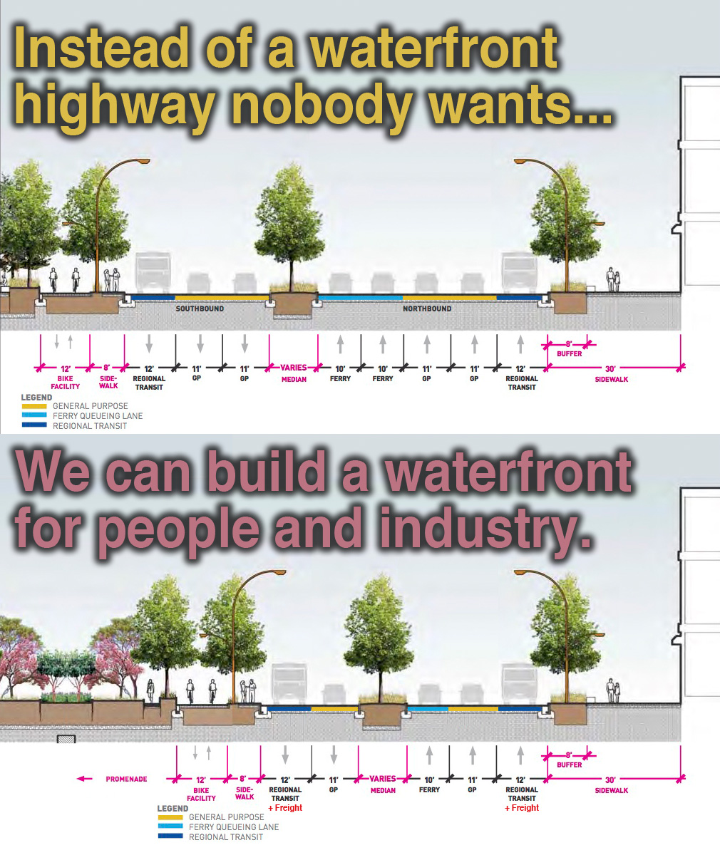
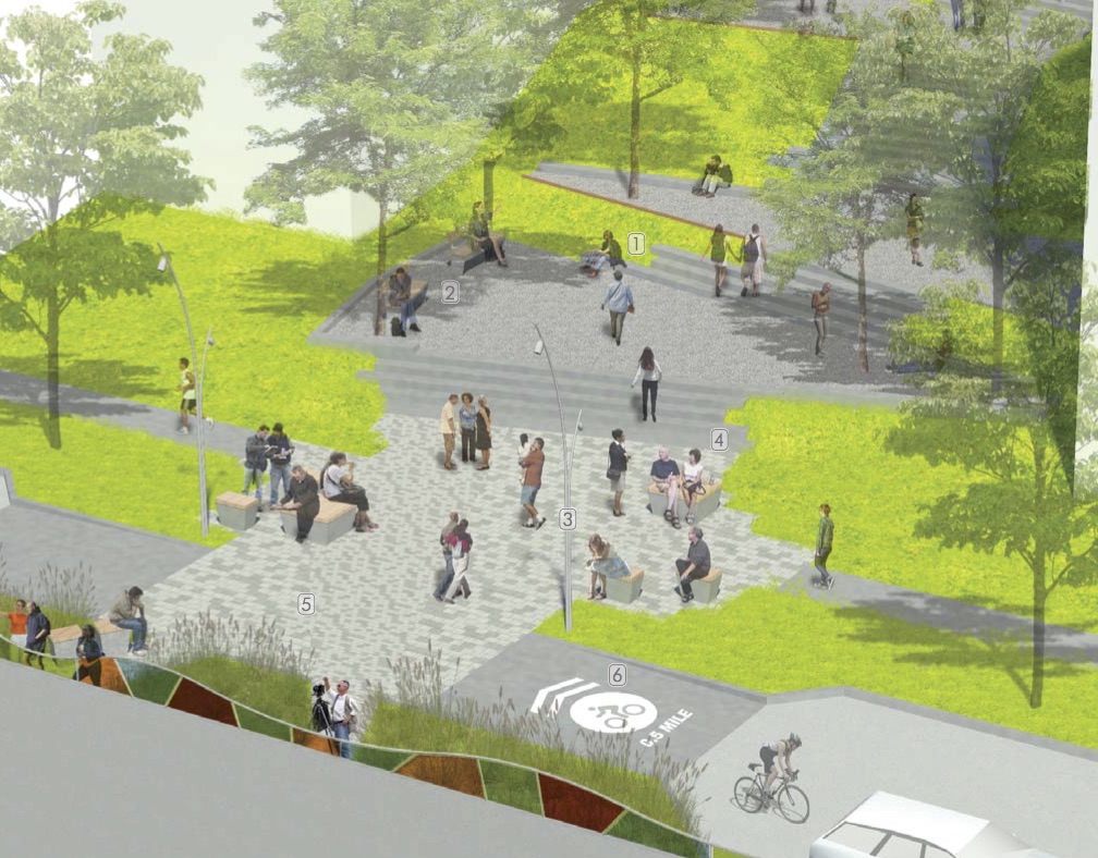
    We have been fully against the state’s horrendous plans for a surface highway on the reconstructed downtown Seattle waterfront ever since the agency dropped its first looks.

    It is still horrible. There are simply too many lanes of traffic, leading to very long crossing distances and creating dangerous and likely deadly conditions for people moving between the downtown core and the newly-rebuilt waterfront.

    The state needs to drop one of the general purpose lanes in each direction. They are already digging a highway tunnel at immense (and growing) cost. We don’t need or want a surface highway to complement it.

    Josh Cohen dives into the issue in a recent story for Next City:

    “When you get to south of Columbia you still have an eight-lane highway,” says Quinn. “The waterfront is a transportation hub for people walking. We’re the most vulnerable. But we’re not being prioritized, we’re being compromised.”

    Part of the problem stems from the many, many competing needs of the major north-south corridor. As Quinn says, there is significant foot traffic from tourists, ferry riders, bus riders and residents. There is bike traffic. There will be heavy car traffic from drivers getting off the ferry and people heading into downtown since the highway tunnel will bypass downtown. Alaskan is an important route for freight traffic coming out of the port. And the ferry uses space on the road to queue its car traffic.

    “There’s so much trying to happen in a constrained space it does have a very practical challenge in terms of the width of that road,” says Marshall Foster, director of Seattle’s Office of the Waterfront. “We’re trying to strike this very, very hard balance. But without throwing someone off the island — transit or ferries or something else — this is the optimized solution that’s going to make everybody be able to do what they have to do.”

    Compelled by feedback from constituents (including a set of strongly worded letters co-signed by Feet First, Transportation Choices Coalition and Cascade Bicycle Club), the city looked at alternative designs that could narrow the road width. But Foster says freight capacity and ferry queuing lanes weren’t up for negotiation, and projected traffic volumes will require two general travel lanes in each direction. So dedicated transit lanes were the only thing on the chopping block, an outcome nobody wanted.

    But the plan does “throw someone off the island.” That’s what we’re saying. The plan is not safe or comfortable for people on the ground. Or to phrase that another way: “Projected safety and public comfort needs will require fewer lanes in each direction.”

    Vision Zero says that deaths and serious injuries are preventable, buy only if cities and states make safety the top priority in their street designs. If you compromise safety, then you are contributing to death and injury. Stop.

    It seems the bureaucratic, public feedback route isn’t working here. They aren’t listening. Is it time to start planning protests?

    waterfront

    — Advertisement —
  • Gone Bikin’: Community-led Melrose Promenade project gets $3 million from Feds

    IMG_2882.JPGSeattle Bike Blog Editor Tom Fucoloro has Gone Bikin’ until Labor Day. In the meantime, we will be periodically posting short news bits and excerpts from good reads floating around the web.

    My favorite description of the Melrose Promenade concept is “Capitol Hill’s front porch.” Because the underutilized street with incredible views should be both a major non-motorized route and a great place for people in the city’s densest neighborhood to hang out.

    Back when I was active in Central Seattle Greenways, the group helped project volunteers (like dedicated visionary Mike Kent) win some city grant funding for planning and community outreach. So though I have not been personally involved in the project since then, it’s amazing to see all that work come to fruition with $3 million in funding for construction. I can’t wait to see it in action.

    More on the grant funding from Scott Bonjukian at the Urbanist:

    Today the street is bombarded with the roar of freeway traffic and has a narrow sidewalk on only one side, offering not so much as a street tree or bench in this high density neighborhood. But the street also offers stunning views of the city skyline and the Olympic Mountains beyond. Urban planner and local resident Mike Kent saw a disconnect between Melrose Avenue’s poor conditions and its views of the city. Six years ago he started recruiting friends, neighbors, local organizations, and business owners to advocate for safety changes and public space improvements.

    In 2012, a $20,000 grant from the City of Seattle enabled the Melrose Promenade Advisory Committee to hire design consultants and host several public workshops. These helped shape the community’s vision for what Melrose Avenue could become. The work led to an 88 page concept plan (PDF) which includes site analyses, public feedback, and schematic renderings.

    Billing itself as “the front porch to Seattle’s Capitol Hill”, the concept plan has a variety of elements that support a mix of street users:

    • Part of the “active urban” south of Denny Way is envisioned as a curbless festival street with adaptable furniture and lighting elements. The area between Pike Street and Olive Way has a number of retail establishments that draw foot traffic day and night.
    • The “overlook” north of Denny Way may have elements like curb bulbs, seating, and translucent panels on the edge of the freeway to make Melrose more inviting for people walking and to enhance the skyline views. The hill climb at Harrison Street, which consists of a narrow stairway today, is widened into a larger gathering and viewing space (see the next image below for a comparison).
    • The “park” section would enhance the multi-use trail running through Bellevue Place Park and potentially create new retaining walls and terraces to make the park more useable and attractive as a gathering space.

    Read more…

    Overlook concept from the excellent and extensive Visioning Project (PDF)
    Overlook concept from the excellent and extensive Visioning Project (PDF)
    — Advertisement —
— Advertisement —

Join the Seattle Bike Blog Supporters

As a supporter, you help power independent bike news in the Seattle area. Please consider supporting the site financially starting at $5 per month:

Latest stories

— Advertisements —

Latest on Mastodon

Loading Mastodon feed…