— Advertisement —
  • Cascade calls for more bike/walk station access funds in ST3

    Way cheaper and more efficient than a parking garage
    Way cheaper and more efficient than a parking garage

    Sound Transit’s latest ballot measure draft would spend $661 million in transit funds to build car parking near stations. Seattle Transit Blog did the math and found that each new parking space would cost $80,000. To put that in perspective, a person could park their car at a station every day for 50 years and Sound Transit would pay them $4.38 per day to do it. That’s basically the cost of their round-trip fare.

    The budget for new car parking at stations is double the budget for biking and walking access improvements to those same stations.

    And not only will these biking and walking projects help people get to light rail safely and easily, they will also make the neighborhoods around the stations better places to be. Sound Transit can pay for the stations access and get the improved livability for free.

    Cascade Bicycle Club has an action alert out calling on Sound Transit to increase the biking and walking access funds to $500 million. One way to fund this increase: Simply charge for parking at stations. This would have the added benefits of incentivizing people to get to stations by another means if possible and charging people more of their fair share.

    Sound Transit already charges for secure bike parking, and bike parking costs a minuscule fraction of that $80,000 per car space. (more…)

    — Advertisement —
  • Man biking in Bellevue catches his own scary hit and run on video

    Still from the video. Police are looking for a black Ford F150, possibly with a license plate starting "D9"
    Still from the video. Police are looking for a black Ford F150, possibly with a license plate starting “D9”
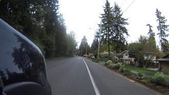
    Dan Scarf was in a pretty “mundane” part of his bike commute home to his wife and three kids on a street marked for 25 mph and calmed with speed humps when someone driving a black Ford F150 struck him hard and fled the scene without stopping.

    “I’m really angry at the guy, and I’m just shocked,” Scarf said. “How could you actually do it?”

    Scarf’s hip was broken in the crash, which happened around 5:30 p.m. April 13 on 161st Ave SE just south of SE 28th Place in Bellevue.

    He caught the collision on a handlebar-mounted camera, but the video didn’t get a shot of the person driving or the license plate number. Scarf posted the video to YouTube (collision happens at the 2:00 mark):

    (more…)

    — Advertisement —
  • Arena plan would build pedestrian bridge for Holgate, needs bike lanes on 1st Ave

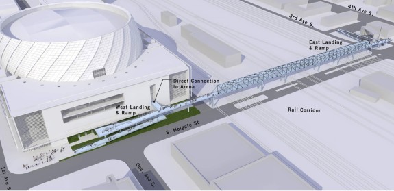
    Concept art for the proposed Holgate bike/walk bridge. Images from a presentation to the City Council's Sustainability and Transportation Committee
    Concept art for the proposed Holgate pedestrian bridge. Images from a presentation to the City Council’s Sustainability and Transportation Committee (PDF).

    The team putting together a plan for a new arena directly south of Safeco Field plans to build a new pedestrian bridge over the train tracks on S Holgate Street as part of a multi-million dollar public benefits package to pay the city for Occidental Ave, which lies in the path of the proposed arena footprint.

    This project has sparked controversy for some (especially freight companies) and hope for others (especially for those who want an NBA team in town). But for the sake of this blog, we are only going to be looking at the impacts and proposed public benefits that affect biking and safe streets. Ultimately, I’m pretty sure the project will live or die based on other factors, but I’ll leave that story to other reporters.

    One of the major hurdles for project approval is the “street vacation” of Occidental Ave, since that requires City Council approval. That’s why the Seattle Arena team is headed to the City Council Sustainability and Transportation Committee tomorrow (Tuesday) during their 2 p.m. meeting.

    Proposed Holgate Bridge

    Presentation (41916)-bridge2 (more…)

    — Advertisement —
  • Bike around South King County for Cascade’s Major Taylor Project Saturday

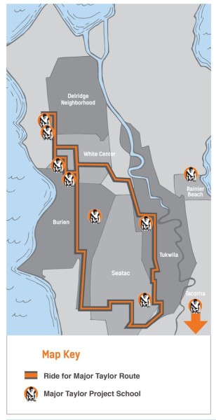
    Cfx4GH-UYAE5eZ3Cascade Bicycle Club’s Major Taylor Project offers after-school programs for students at 14 schools in South King County and Pierce County.  “Bike Club” provides 300 students “a forum for helping students develop confidence, goal setting abilities, bicycle maintenance and handling skills, and deep connections with their peers and communities,” according to Cascade.

    Saturday’s Ride for Major Taylor starts at Chief Sealth High School in West Seattle and heads through White Center, Burien, Seatac and Tukwila. Proceeds from the ride will go to support the program.

    Ideally, you have already been getting friends and family to pledge cash for your Major Taylor fundraiser. But if not, no worries! You can register at the start line between 9 and 10 a.m. for $60 ($50 if you’re a member). Anything above the registration fee is a donation. It’s a good cause if you have the cash.

    More details from Cascade: (more…)

    — Advertisement —
  • Seattle’s baffling short-term bike plan cuts safety, pretends downtown doesn’t exist

    central19

    In five years, the city's network of all ages and abilities bike routes will still be disconnected according to the latest update
    In five years, the city’s network of all ages and abilities bike routes will still be disconnected according to the latest update

    With the 2nd Ave protected bike lane pilot demonstrating Seattle’s vision for more ambitious, safe and comfortable bike routes downtown and beyond, Seattle voters approved an unprecedented transportation levy by a big margin. Mayor Ed Murray, his transportation advisors and the staff at the Seattle Department of Transportation laid out a bold vision, and the people said, “Hell yes.”

    So with all this momentum and a fresh voter mandate to make bold safety and bike network improvements in hand, the city’s newest annual update of the short term bike plan (AKA the Bicycle Master Plan Implementation Plan, or the Bike Plan Plan) is baffling.

    The five-year total for protected bike lanes has been cut from 36 miles to 25 miles compared to last year’s version, and the total for neighborhood greenways has been cut from 52 miles to 32 miles.

    These are vital public safety projects designed to prevent serious injuries and deaths on our streets, yet the city plans to cut one in three projects from the five-year work plan. If the city hasn’t abandoned its Vision Zero goal — which calls for a specific focus on biking and walking safety — then it has at least made it a much lower priority.

    “Through smarter street design, targeted enforcement, and education, we will make our streets even safer for people of all ages and abilities, especially pedestrians and people on bikes, as they’re the most vulnerable to death and injury on our streets,” Mayor Ed Murray wrote in his introduction to the city’s 2015 Vision Zero Plan.

    And the city’s improvements are working. If it hadn’t been for the Ride the Ducks tragedy, 2015 would have been the city’s safest year in generations. This is no time to slow down on our safe streets work. Seattle is among the only major US cities with Vision Zero in sight. We have a moral obligation to keep working as hard as we can to get there.

    That’s why biking and safe streets advocates in neighborhoods across the city were devastated to see the newest short-term bike plan (PDF). In many neighborhoods, the hard work to organize and push for safety improvements and a connected bike network have literally been wiped from the map. (more…)

    — Advertisement —
  • The network effect: For the 1st time, 2 neighborhood greenways in Seattle have crossed

    A new street park designed to make this mega intersection safer and increase public space at the same time
    A new street park designed to make this mega intersection safer and increase public space at the same time

    BallardMapBallard’s new 17th Ave NW neighborhood greenway officially marks an important step in the city’s all ages and abilities bike network: Two neighborhood greenways have finally crossed each other.

    It’s hard to believe it took until 2016, but at least in Ballard neighborhood greenways are starting to form a functional network.

    The new 17th Ave NW greenway is very long, stretching from Ballard Ave to Whitman Middle School in Crown Hill. And with the connection to the NW 58th Street neighborhood greenway, every home and destination along the way also connects to the section of the Burke-Gilman Trail leading to Golden Gardens.

    The features of the new greenway are mostly familiar at this point: Speed humps, stop signs turned to face cross-streets to give the greenway priority and busy street crossing improvements. It’s an easy gradual climb heading north, setting the stage for a wonderful and flat connection to Greenwood, Green Lake and beyond.

    The biggest disappointment in the route is the lack of a connection to the Burke-Gilman Trail from the south end. Instead, the greenway drops you off on Ballard Ave and leaves you navigate the notorious Missing Link on your own. This missing section of trail has been wrapped up in decades of legal wrangling and is currently going through a lengthy environmental review process. Presumably, when the trail is finally constructed, the greenway will connect to it. But that could take a while…

    All-in-all, though, this is a well-executed addition to the neighborhood, something that can’t be said for some other recently-complete neighborhood greenways (stay tuned).

    Here’s a photo tour of the route, starting at Ballard Ave and Dock Place: (more…)

    — Advertisement —
— Advertisement —

Join the Seattle Bike Blog Supporters

As a supporter, you help power independent bike news in the Seattle area. Please consider supporting the site financially starting at $5 per month:

Latest stories

— Advertisements —

Latest on Mastodon

Loading Mastodon feed…