— Advertisement —
  • Listen: The Bicycle Story podcast takes on the history of the sharrow

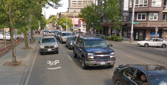
    Sharrow on NE 45th Street in the U District. Image: Google Street View
    Sharrow on NE 45th Street in the U District. Image: Google Street View

    Seattle’s unofficial motto could easily be “The City of the Sharrow.” Keegan Hamilton at the Seattle Weekly once suggested the Seattle Sharrows as a name for a D-League basketball team.

    And sure, why not? Take one glance at major streets in all corners of the city, and you’re bound to see two chevrons with a bicycle icon beneath it. The sharrow is the city’s most prolific graffiti tag.

    There’s a reason I used the color-inverted sharrow as the logo for this blog (other than the free public use rights and a vague allusion to me writing with ink versus the city’s white road paint). In some ways, this simple icon tells the story of biking in Seattle perfectly: We’re a city that wants so badly to appear to be trying to make cycling safer and more accessible, but is so scared of actually making a significant change to roadway design that might upset anyone, that we have to-date painted well over 3,000 of these markings.

    92 miles of the city’s claimed bicycle network consists of “shared lane markings.” These 92 miles are why you could be fooled looking at the official Seattle Bike Map into thinking the city’s bike network is fairly complete and connected. Of course when you actually get out on the streets, you encounter roads like NE 45th Street pictured above (and noted as a bike route on the bike map). Yeah, no.

    Well, initial findings from a recent study out of CU Denver suggest that shared lane markings have had either no impact on biking rates and biking safety or may even have a negative impact. These results still need peer review, but they likely are not surprising to anyone who has found them of little help on major busy streets.

    Seattle’s Josh Cohen has produced a great report for his most recent podcast at The Bicycle Story. Cohen not only spoke with one of the study’s authors, Wes Marshall, but he also tracked down James Mackay, a bike planner who invented the sharrow for the City of Denver in the 90s and helped get the marking into the national traffic design standards.

    “Bikes almost became extinct in America, so it’s sort of like reintroducing them,” Mackay told Cohen. And the sharrow was invented for the reason you might expect: City leaders wanted to do something for biking without impacting general purpose or parking lanes. In a way, they were just to officially communicate that bikes do have a legal right to be on a street and should be expected there.

    “The evolution of sharrows over the last two decades parallels the evolution of biking as transportation in America over the same period,” Cohen concludes, “they were [created] in an America that saw bikes as exercise equipment and children’s play things. (more…)

    — Advertisement —
  • Work starts soon on major Roosevelt Way repaving & redesign, will last most of 2016

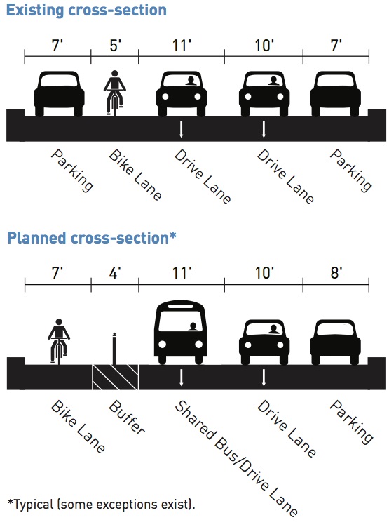
    2016_0203_Roosevelt_Way_Fact_Sheet-cross

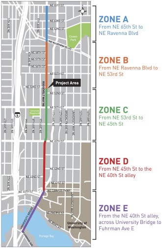
    FINAL_Roosevelt_Boards_web_20160125-zones
    Images from SDOT.

    Major work to repave Roosevelt Way and rebuild it with transit, biking and walking improvements starts March 14, SDOT says.

    The major repaving project is expected to take at least until September before the whole length from NE 65th Street to the south end of the University Bridge is completed.

    Work will happen in phases starting at the north end from NE 65th to Ravenna Blvd. Expect detours and delays. Most significantly, three weekends will require full closures of the U Bridge. We will attempt to keep on top of these closures so you can plan accordingly.

    Zone E work, which covers the U Bridge, can happen at any time during the construction process, but the other zones should not have overlapping work. This may be a lesson learned from the 23rd Ave project underway currently in the Central District.

    As we reported previously, the plan for the bike lane on Roosevelt appears to be a big improvement from the existing paint-only door zone bike lane. But several major intersections will not get the fully-separated treatment, requiring users to mix with turning cars.

    Along with the under construction Westlake Bikeway, the Roosevelt project is one of the most significant projects for bike access and safety on tap for 2016. (more…)

    — Advertisement —
  • No longer on the chopping block, State looks to invest in the John Wayne Trail

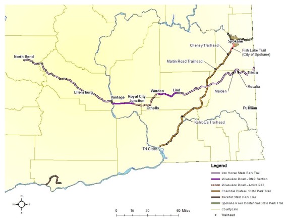
    IMG_2183DocumentThe movement to save and improve the state-spanning John Wayne Pioneer Trail (AKA the Iron Horse Trail) has turned out so strongly across Washington that rather than trying to give trail land away, Senate leaders are hoping to invest $100,000 into making it work better.

    In a letter to supporters, the Tekoa Trail and Trestle Association (“TTTA”) celebrated the news, saying, “Friends we have turned the tide!” (You can support the group’s efforts financially via their crowdfunding campaign).

    The funding — if it makes it through the rest of the budget process — would improve weed control along the trail, a common complaint by landowners who say the unkempt trail serves as a pathway for invasive and noxious weeds that harm their farm and grazing lands. Improving weed control is a step toward protecting and investing to activate this incredible asset in our state.

    Meanwhile, the State’s Parks Department is in the midst of a planning project for the trail with public meetings scheduled today (Tuesday) in Cheney and tomorrow in Ellensburg to “gather information and comments from the public that will help lead to a long-term plan for the John Wayne Pioneer Trail. At these meetings, State Park staff will have a presentation followed by a breakout session to collect public comments on a range of trail-related issues, including noxious weed and vegetation management, trailhead and camping opportunities, fencing and trail-use permits.”

    The message for Parks is clear: Make it easier for trail users to access the trail and invest to develop it into the incredible cross-state adventure and local-economy-boosting pathway it could be.

    Meeting details from the TTTA: (more…)

    — Advertisement —
  • Reopened street near Capitol Hill Station improves access to Broadway Bikeway

    denny way open
    Green lines: Quality bike access now open. Flags: Capitol Hill Station entrances to open later this month.

    The north end of the Broadway Bikeway just became infinitely more useful as construction crews finally reopened Denny Way between Broadway, 10th Ave and Cal Anderson Park.

    Closed for years to build Capitol Hill Station, this section of Denny Way opens a vital low-traffic bike route connecting Broadway and the western part of the neighborhood to Cal Anderson Park and calm neighborhood streets east of Broadway.

    Due to the park’s limited bikeable access points and Seattle Central College’s multi-block campus, Denny is the first complete bike connection north of Pine Street. So while opening this one block may not seem like all that big of a deal on a map, on the ground it’s a huge improvement, especially for people trying to avoid the very busy Olive Way/John Street. To date, the Broadway Bikeway has effectively been a local-access-only dead-end north of Pine unless you are comfortable mixing with busy traffic on John/Olive or north Broadway. But not anymore.

    IMG_4066 (more…)

    — Advertisement —
  • Bike News Roundup: The world’s biggest city has few bike lanes, yet people bike a lot anyway

    It’s time for the Bike News Roundup! Here’s a glance at some of the bikeish stuff floating around the web.

    First up! Lots of people in the world’s most populous city bike despite few bike lanes:

    The Gaman Spirit: Why Cycling Works in Tokyo from STREETFILMS on Vimeo.

    (more…)

    — Advertisement —
  • 2nd Ave getting upgrades + Extension to Denny possible this year

    Vancouver bike lanes use planter boxes (and usually curbs) to separate bike lanes downtown.
    Vancouver B.C. bike lanes use planter boxes (and usually curbs) to separate bike lanes downtown.

    After nearly a year and a half as a pilot project, the 2nd Ave bike lane is getting some significant — and hopefully more comfortable and attractive — upgrades.

    Among the improvements are new planter boxes to help separate the bike lane from travel and parking lanes in addition to the existing reflective plastic posts.

    We’ve already reported about signal improvements underway to clear up confusion about which signals apply to which lanes. Not all of those will be done by May, but work is ongoing SDOT staff said during Wednesday’s meeting of the Seattle Bicycle Advisory Board.

    SDOT staff are also working on a “conceptual” design for a 2nd Ave extension from its current terminus at Pike to Denny Way. There are no real surprises in the concept design since it is very similar to the existing section south of Pike.

    Work is still early, and staff plan lots of outreach including mailers, stakeholder briefings and door-to-door flyer efforts. (more…)

    — Advertisement —

2024 Voter Guide


— Advertisement —

Join the Seattle Bike Blog Supporters

As a supporter, you help power independent bike news in the Seattle area. Please consider supporting the site financially starting at $5 per month:

Latest stories

— Advertisements —

Latest on Mastodon

Loading Mastodon feed…