— Advertisement —
  • SDOT is nearing final design for the Georgetown to Downtown bike route

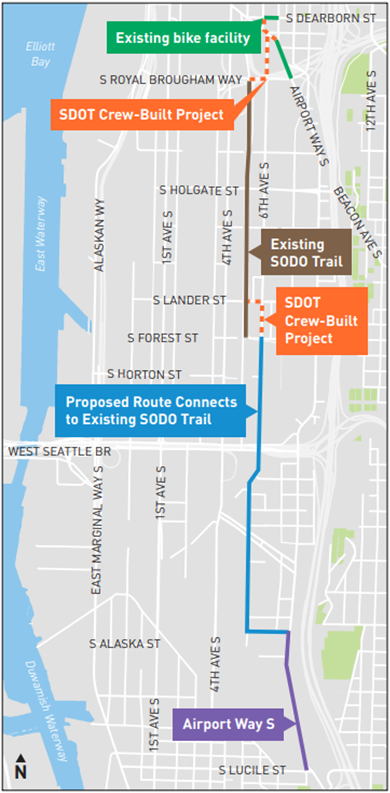
    Map showing the project route.

    The design for the Georgetown to Downtown Safety Project, which will build a long-awaited and sorely needed bike connection, is nearing completion. The biggest changes are that the route will now access the SoDo Trail via S Lander Street rather than S Forest Street, which the SoDo Business Improvement Area requested. They have also revealed their plan to connect the SoDo Trail to downtown via S Royal Brougham Way and 6th Ave S, which is currently closed completely where it passes through the Home Base-Salvation Army shelter.

    The schedule calls for final design to be complete soon and for construction in 2024.

    SDOT is hosting a meeting 6 p.m. tonight (Nov. 30) to discuss the latest changes. Details for joining the meeting:

    Join us for a virtual public meeting on Thursday, November 30 from 6 – 7 PM to hear about project updates. We’ll highlight what’s new in the design plans, share more about the outreach we’ve been doing with the SODO Business Improvement Area (BIA), and host a live Q&A. We hope to see you there!

    When: Thursday, November 30 | 6:00 – 7:00 PM

    Where: Zoom Meeting

    (click to join)

    Call-In Option: Prefer to join by phone? Follow these instructions:

    Dial: +1 (253) 215-8782

    Enter Meeting Number: 872 7061 6400

    — Advertisement —
  • Alert 11/27-12/8: Burke-Gilman Trail closed for repairs near Matthews Beach – UPDATED

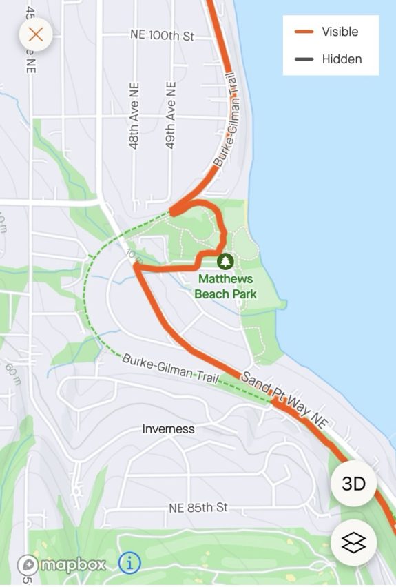
    Map showing the section of the trail that is closed for construction.
    Interactive map.

    UPDATE 12/1: Reader Chris says the trail is temporarily open again, and the signs now say that the detour will return 12/4-8. The Fix the Burke-Gilman Facebook page (definitely worth following to stay up to date on these closures) posted an update from the project team: “They moved some of the detour signs around and hope to finish the section from the north end of the overpass bridge to NE 97th next week Tuesday, Wednesday, Thursday if the weather permits. The detour will take you off the Burke-Gilman just south of the overpass bridge to NE 95th down to Sand Point Way where you will need to cross Sandpoint Way and then take NE 97th where you will be able to get back on the Burke-Gilman Trail to continue to heading North. If you are heading south, you will need to do the detour in reverse getting back on the trail south of the bridge. With the wetter weather predicated, I suspect that the work on the next section, between NE 97th and NE 112th won’t start back up until early spring 2024.”

    Seattle Parks is repairing bumps on the Burke-Gilman Trail between Inverness Drive NE and NE 97th St near Matthews Beach Park. Work is already underway and is expected to continue until December 8.

    This section was very bumpy, so some trail repairs are very welcome. There is a detour in place, but I do not have a map of it. If you’ve ridden through, let us know in the comments how the detour worked for you.

    This work was originally scheduled to begin in late August, but was delayed. The project website also lists trail work from 97th to 112th that has also been delayed. I have asked Parks for updates on that work and any other upcoming trail closures. We did not find out about this work until readers started sending us messages.

    UPDATE: Big thanks to reader Stephen for sending us this map of the detour route:

    Map of the detour route, which travels along Sand Point Way and then through paths in Mathews Beach Park.

    Note that sections of Sand Point Way do not have sidewalks or even decent shoulders for some of this length. This is another reason to alert the public of these construction plans: To get feedback on the planned detour.

    — Advertisement —
  • SDOT releases early design for Leary/Market bikeway, seeks feedback

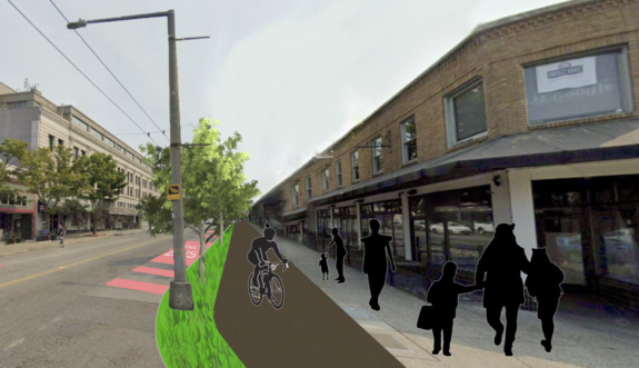
    Concept photo of Market Street with bike lane drawn next to the sidewalk.

    The day before Thanksgiving, SDOT released a first look at their design concept for a Ballard Missing Link bike route alternative following 17th Ave NW, Leary Way and Market Street. The plan includes a 10-foot-wide “multi-use trail” on one side of the street as well as significant traffic calming and safety upgrades to Leary Way especially. However, the Market Street design points to why that short section will be by far the most difficult part, and the initial design calls for a significant reduction in the sidewalk space and removal of trees.

    The team is working on a rushed schedule with hopes of reaching 30% design by the end of 2023. They will be out at the corner of NW Market Street and 24th Ave NW from 3–5 p.m. Tuesday (Nov. 28) collecting feedback. You can also complete their very short online survey.

    Market Street

    Let’s start with the trickiest part: NW Market Street between Leary Way and 24th Ave NW, where the existing not-a-trail section begins. This is the heart of Ballard’s business district and has a ton of people on foot. It also carries Metro’s 40 and 44 bus routes. The 44 in particular is one of Metro’s busiest routes. Car volumes are not actually too bad, with SDOT measurements coming in at 10,300 vehicles per day in 2019. For reference, the street carried about 28,600 vehicles per day just a few blocks east near 15th Ave NW, but most people turn before hitting the busy business district. But there are a lot of turning movements, and traffic engineers will need to be careful that cars don’t back up in a way that impedes the bus routes.

    (more…)
    — Advertisement —
  • 48-year-old killed while biking in Kent

    Street View image of a street with five lanes and sidewalks but no bike lanes.
    Approximate location of the collision as of August 2022 via Google Street View.

    A 48-year-old man was killed today in a collision with a 24-year-old driving southbound on Central Avenue South, according to the Kent Police Department.

    Our condolences to his friends and family.

    The collision occurred shortly after 12:30 p.m., and the initial information from the police says the person driving stopped, did not show signs of impairment and is cooperating with the investigation. Police released few additional details, saying only that “witnesses on scene reported seeing the bicycle abruptly turn in front of a vehicle.”

    Take caution not to jump to conclusions based on this early information, however. Full investigations often reveal circumstances much different than initial reports indicate.

    The 800 block of Central Avenue South is in the middle of a half-mile stretch of the avenue without a traffic signal or crosswalk. The street has two lanes in each direction plus a center turn lane. It does not have bike lanes. Ryan Packer reported that the traffic death numbers in Kent have increased dramatically in 2023.

    Anyone with additional information should “call the Kent PD Tip Line 253-856-5808 or leave a tip at [email protected]. Refer to Kent Case Number 23-15895.”

    — Advertisement —
  • Council passes budget with Mt. Baker, S Henderson safety projects + more

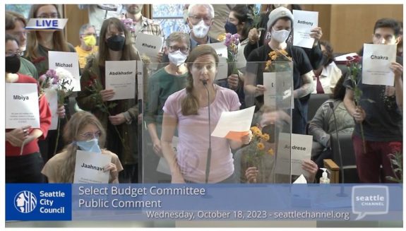
    Screenshot from the Seattle Channel telecast of a budget hearing with many people standing behind a speaker holding signs with people's names.
    Seattle Neighborhood Greenways organized a group to advocate for safer streets by holding up the names of victims of traffic violence during a budget hearing.

    For a budget cycle with tough revenue projections, the City Council still added some excellent street safety projects and mostly protected safety efforts from cuts. The Council passed the 2024-25 budget Tuesday after weeks of hearings and debates.

    Highlights include $1.4 million to “transform the Mt. Baker station area into a safer and comfortable place for people to walk, bike, and make transit connections; and for the Mt. Baker Town Center to take root and flourish,” according to the budget document (PDF). The Council also earmarked funds from the sale of surplus SDOT property to the Thomas Street redesign between South Lake Union and Seattle Center and to a traffic calming project on S Henderson Street in Rainier Beach. Both of these projects are major needs with big potential to improve mobility and keep people safe.

    Unfortunately, the Council did approve a $1.4 million cut to the School Safety and Pedestrian Improvement Fund with SDOT noting their intent to complete planned projects using Vision Zero and ADA accessibility improvement funds. These pools need to grow, not shrink as every penny invested here makes our city safer for everybody. Oddly, though, the Council saved the $1.5 million for the sorely lacking NE 45th Street overpass fence funds, a project that we have argued needs to go back to step one because it falls desperately short of what is actually needed and might even make the real safety improvements more difficult and expensive in the future. Perhaps there is still time to steer this project toward a better outcome, but I’m surprised the Council saved this project while cutting the same amount from the Vision Zero and ADA budgets.

    (more…)
    — Advertisement —
  • Watch: Best Side Cycling rides Cranksgiving

    Hanoch Yeung rode Cranksgiving for his first time and documented the whole thing. As the organizer, I have never actually ridden Cranksgiving myself. So I loved getting a glimpse of what it’s like. Check it out. And be sure to subscribe to Best Side Cycling on YouTube.

    — Advertisement —

2024 Voter Guide


— Advertisement —

Join the Seattle Bike Blog Supporters

As a supporter, you help power independent bike news in the Seattle area. Please consider supporting the site financially starting at $5 per month:

Latest stories

— Advertisements —

Latest on Mastodon

Loading Mastodon feed…