— Advertisement —
  • No Federal money for Northgate bike/walk bridge, Pronto expansion

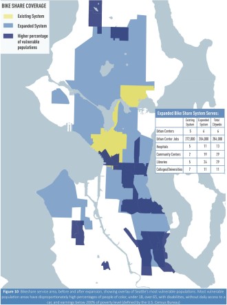
    A plan to expand Pronto aims to reach "vulnerable" populations. Map from Seattle's pending TIGER grant application.
    A plan to expand Pronto aims to reach “vulnerable” populations. Map from Seattle’s pending TIGER grant application.

    Well, it was worth a shot.

    The Feds did not pick Seattle’s TIGER grant proposal for funding the Northgate bike/walk bridge and a “massive” Pronto Cycle Share expansion, SDOT confirmed today.

    The news comes one day after Senator Patty Murray announced a $15 million TIGER grant for Tacoma LINK and $10 million to construct a new ferry terminal in Mukilteo. The Seattle grant proposal was conspicuously missing from Murray’s announcement.

    The Seattle proposal requested $25 million in Federal funds to help fill the $15 million funding gap in the Northgate bike/walk bridge project and to improve connectivity to transit by investing $10 million in a dramatically expanded bike share system. The city would match this with $5 million of its own, while Pronto’s private operator Motivate would pitch in $3 million.

    Since the application, the state passed a transportation funding package that includes $10 million for the Northgate bridge project. UPDATE: The Move Seattle Levy also includes funding for the Northgate bridge, so with the TIGER grant out it’s that much more important to pass Seattle’s Prop 1.

    But the city was still hoping at least for partial grant funding to help expand Pronto’s reach. Today, only 14 percent of Seattle residents live within an easy walk of a station. Under the expansion plan, 62 percent of residents would live within reach.

    With the TIGER grant out of the picture for at least a year, the city still intends to move forward with an expansion. Mayor Ed Murray’s proposed 2016 budget includes $5 million for expanding Pronto. If that funding is approved by the City Council, the path forward really hinges on whether the city focuses on expanding the station area or on electric bike technology. (more…)

    — Advertisement —
  • Today: Join a community walk in Greenwood for Move Seattle

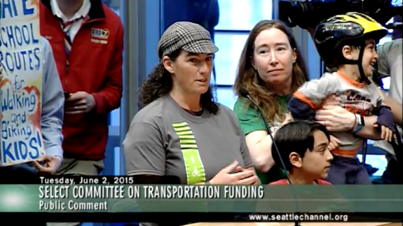
    Morgan Scherer of Family Bike Seattle testifies at the hearing. With her: Margaret McCauley and kids. Community support expanded Safe Routes to School funding in the levy plan.
    Morgan Scherer of Family Bike Seattle testifies at a Move Seattle hearing. With her: Margaret McCauley and kids. Community support expanded Safe Routes to School funding in the levy plan.

    Did you know the Move Seattle levy will build a road safety project at every single public school in the city? It’s true! And that’s just one example of a community-generated idea in the nine-year transportation levy.

    But boosting Safe Routes to School funds in the levy plan is only effective if we then go and pass it. That’s why Feet First, Seattle Neighborhood Greenways, Cascade Bicycle Club and the Let’s Move Seattle campaign are holding a community walk in Greenwood today to highlight safety problems in the neighborhood and demonstrate how passing Move Seattle will help keep everyone safe.

    Meet at Greenwood Elementary at 2:45 p.m. (walk starts at 3). Walk will end at Razzi’s Pizzeria, where you can stay and help out at a phone bank if you want to do even more.

    Because if our neighborhood streets are safe for children, they are safe for everyone else, too.

    Details from Feet First: (more…)

    — Advertisement —
  • Seattle releases unique walking and biking maps for each public school

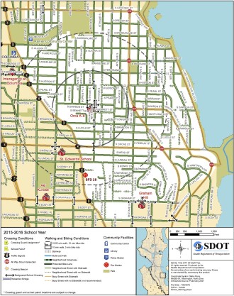
    Map for Orca K-8
    Map for Orca K-8

    Earlier this month, we reported on the city’s fantastic School Road Safety Plan, designed to help schools, parents, students and the city all work together to end traffic deaths and injuries near schools.

    Well, one cool part of that plan was to improve the existing walking maps for each school and add information to help families identify a safe biking route to class. The city released those maps recently.

    By marking every single sidewalk and highlighting the best crosswalks, the maps are much more useful for families trying to find the safest and easiest route for their child to bike or walk (though it would be cool to add topographic info for steep hills). The maps also include circles to help you estimate how long it will take to walk or bike to class.

    Aside from being good resources for picking a route to school, however, they are also very useful for trying to address your school’s unique transportation challenges. As the map for Orca K-8 above shows, most of the school’s walk zone (where the District does not provide buses) is within a 20–25 minute walk or 10 minute bike ride.

    But compare that to Rainier Beach High School, where students are currently protesting the huge walk zones for middle and high schools, arguing that more (or all) students should get free ORCA passes to help them get to class. Look how far many “walk zone” homes are from the 20-minute walk circle around the high school: (more…)

    — Advertisement —
  • A closer look at the Eastside Trail plans + Give feedback online

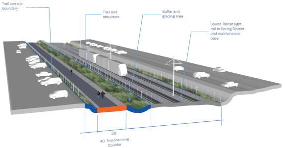
    Example of trail section with planned Sound Transit light rail in Bellevue
    Example of trail section with planned Sound Transit light rail in Bellevue. Images from King County.
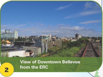
    You've never seen Bellevue like this before.
    You’ve never seen Bellevue like this before.

    A bikeable and walkable Eastside Trail can’t come soon enough.

    The rails-to-trails potential for the mostly-defunct Eastside Rail Corridor is immense for growing communities east of Lake Washington. Connecting homes to jobs and new regional trail connections across and along 520, a complete and connected Eastside Trial would simply revolutionize people-powered transportation and recreation in the region on a level we haven’t seen since the Burke-Gilman Trail.

    King County is currently working on developing high-level design considerations for a corridor master plan that will guide development of a complete, wide, safe and fully paved trail lined with park-like amenities. At the same time, a parallel effort is underway to remove the rails and create an interim trail much like the amazing Cross-Kirkland Corridor Trail, according to Cascade Bicycle Club’s Eastside advocacy coordinator McKayla Dunfey. But that interim trail process is separate from the master plan, which is focused on the final paved vision.

    King County recently held a series of in-person open houses on the master plan, and now you can give feedback through an online open house until November 12. The plan should be complete and approved by Fall 2016, so be ready to give feedback several times during the next year.

    One of the coolest images the trail planners have put together so far is this map showing anticipated demand for various stretches of the Eastside Trail and connecting trails: (more…)

    — Advertisement —
  • 2015 City Council endorsements

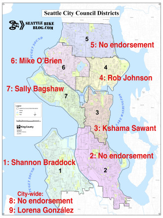
    endorsements2015Before the City Council primary this year, we wrote:

    the biggest mission for this primary should be to knock out the NIMBY candidates who fear change and want to put the brakes on our growing city and the multimodal streets we need to keep it moving. Only two people in each race will go on, and the best case would be for each race to have only genuinely good people running against each other to the November vote.

    And for the most part, we did that. Good work, Seattle!

    In case you still don’t know who to vote for, here are Seattle Bike Blog’s official endorsements for the Council races. Because I did not have the capacity to do full candidate interviews, I’m only endorsing in races where there is a clearly better choice for biking and safe streets. Endorsements are based on coverage in other media, endorsements from safe streets and trusted transportation organizations, and candidate questionnaire responses to Feet First, Seattle Neighborhood Greenways and Cascade Bicycle Club. You can read some other well-thought and relevant endorsement from like Seattle Subway, Seattle Transit Blog, Publicola and Seattlish. (more…)

    — Advertisement —
  • Be prepared for Burke-Gilman Trail detour in Lake Forest Park starting Monday

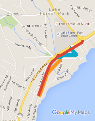
    We compiled this map based on the press release. Click here to view on Google Maps
    We compiled this map based on the press release. Red is the trail closure area. The blue and orange lines are the two detour routes. Click here to view on Google Maps

    King County Parks will remove 40 poplar trees along the Burke-Gilman Trail in Lake Forest Park starting next week.

    This work will require trail detours for two weeks, so be prepared. Luckily, the detours don’t look bad, using nearby low-traffic streets.

    A portion of one of the trees fell onto the highway in an August windstorm, King County Parks says. When they looked into the problem, they determined the trees were dying and posing a hazard. They will be replaced with 40 trees of species that are “more suitable to the locations.”

    Details from King County:

    Beginning Oct. 26, King County Parks will set up temporary detours around segments of the Burke-Gilman Trail in Lake Forest Park while crews begin removing 40 hazardous Lombardy Poplar trees. (more…)

    — Advertisement —

2024 Voter Guide


— Advertisement —

Join the Seattle Bike Blog Supporters

As a supporter, you help power independent bike news in the Seattle area. Please consider supporting the site financially starting at $5 per month:

Latest stories

— Advertisements —

Latest on Mastodon

Loading Mastodon feed…