I got caught out without rain gear the other day, but that’s just a book promo opportunity, right?
We’ve published guides to biking in the rain in the past, and the advice in those posts still holds true (especially this one with lots of advice from readers). Finding proper rain gear that works for you is vital, but it’s about so much more than defense from the elements. For people who want to get around by bike all year, the goal isn’t just to tolerate the rain. The goal is to seek joy in it.
I’m guessing some of you reading this just got finished ringing your socks out in the sink and are thinking, “OK, Tom’s finally lost it.” I know rainy bike rides can be tough, especially when you are caught out without your gear or if you’re just feeling tired and not up for any additional challenges today. I’ve been there.
But I’ve also biked ten miles round-trip taking my kid to preschool in a major downpour and genuinely loved it. Knowing you can keep biking through even the worst Seattle rain does more to keep seasonal depression or malaise away better than anything else I have ever experienced because you no longer feel trapped inside. The rainfall here is a big part of what makes Seattle the amazing place it is. Don’t hide from it. Embrace it.
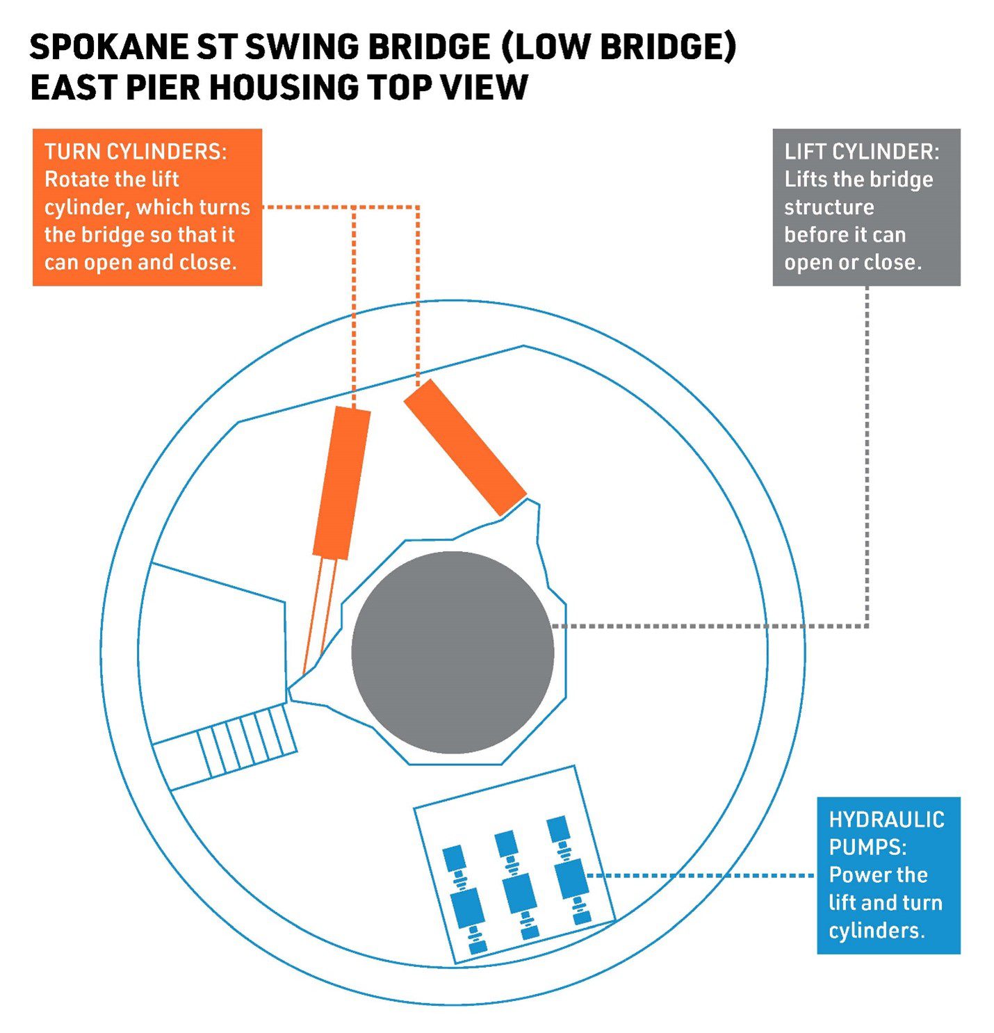
The upcoming closure is to install a repaired turn cylinder. Image from SDOT.
Seattle’s least reliable bridge will be unusable for a week from October 7 through 14, creating a major headache for people who walk or bike between West Seattle and mainland Seattle.
The bridge will need to remain in the open-to-sea configuration while crews replace the faulty turn cylinder that was removed during the previous unexpected closure at the start of the year. Unfortunately, the other three turn cylinders and the control system will also need maintenance soon, so more closures are on the horizon over the next two years but are not yet scheduled.
The King County Water Taxi is running on a 7-day schedule, and the vessel can hold up to 26 bikes. Seattle is covering one round trip on the water taxi per day during the bridge closure if you buy your ticket on the Transit Go app using the rewards code LOWBRIDGE. Learn more in the SDOT Blog post about the closure.
1st Ave S on January 5, 2023. SDOT is not planning a similar temporary bike lane this time.(more…)
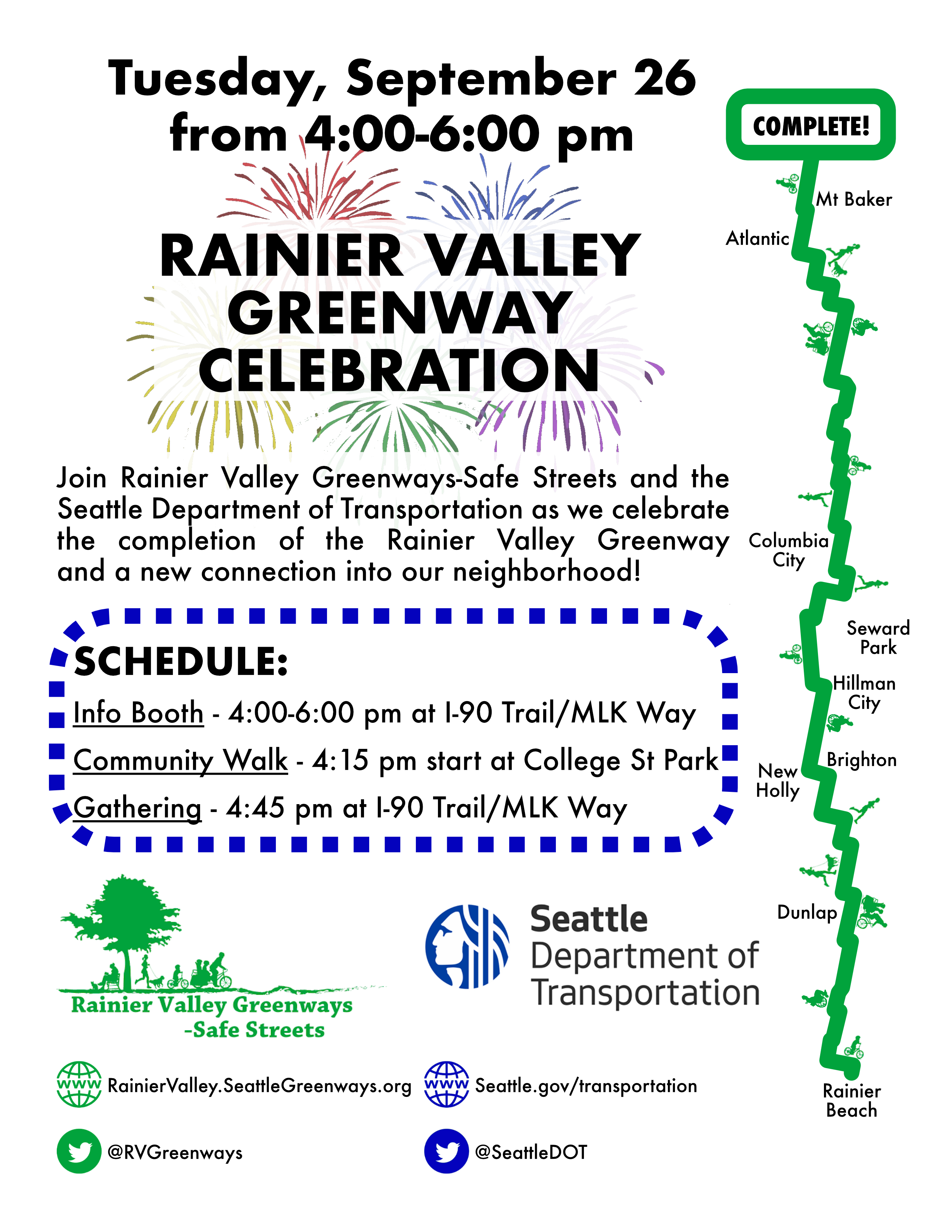
Rainier Valley Greenways-Safe Streets and SDOT are hosting a community celebration of the long-awaited pathway connecting the I-90 Trail in Sam Smith Park to the start of the Rainier Valley Neighborhood Greenway at 28th Ave S.
There will be a community walk at 4:15 p.m. Tuesday (September 26) starting at College Street Park followed by a gathering along the I-90 trail at 4:45.
The new connection may be short, but it was a major headache to get it completed. This tiny trail dramatically improves the usability of the route, linking it with major regional bike routes. You can learn more about the history of the project in our previous post.
A 2018 sidewalk assessment report found a lot of deficiencies with the city’s existing sidewalks.
When Seattle invests in a major road repair project, the city does not always repair the adjacent sidewalks or build new sidewalks if they are missing. Councilmember Tammy Morales has proposed an ordinance that would fix this glaring omission, requiring that “the construction project shall include an evaluation of existing sidewalk conditions and correct any deficiencies identified in the evaluation that are within the major paving project,” according to the proposed ordinance text.
Obviously, this added work would not be free. But there’s no ethical argument for making improvements for people driving while leaving the sidewalks in disrepair. Adding sidewalk assessment, repair and construction work to major paving projects will increase the per-mile cost of the projects, but it’s the right thing to do. Seattle should simply price it into the next transportation funding measure that will replace the expiring Move Seattle levy at the end of 2024.
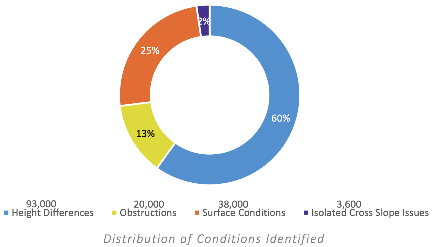
Additionally, repairing sidewalks will be an extremely popular sales pitch to voters, who all have personal experience navigating chunks of Seattle sidewalk heaved comically out of place thanks to a nearby tree root. A 2018 sidewalk assessment study (PDF) found 11,000 blocks that are missing sidewalks and 154,000 instances of sidewalk “deficiencies.” The most common deficiency is the familiar “height difference” issue. The worst deficiency, however, is a sidewalk that’s missing entirely. At our current rate of about 27 blocks of sidewalk per year, it will take 407 years before every street in Seattle has a sidewalk. Voters will certainly agree 407 is too many years.
In addition to requiring sidewalk work as part of major road projects, the ordinance would also direct SDOT to assess nearby sidewalk conditions when conducting smaller projects and prioritize sidewalk repair and construction if the location meets certain conditions. For example, if the location is along a school, park or transit access route or if “the absence of a sidewalk substantially impairs pedestrian movement” within the project boundary. This section does not outright mandate such work, but perhaps it could insert sidewalk work into the department’s regular workflow when it goes out to make patch jobs and other smaller fixes to the streets.
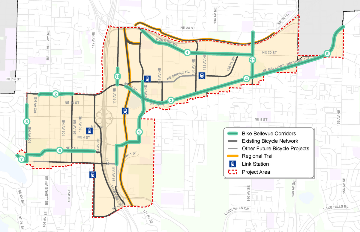
Rather than going project-by-project to build one-off bike projects, Bellevue is currently planning a more comprehensive and less incremental approach. The Eastside city is currently seeking feedback on what they are calling “Bike Bellevue,” a network of 11 projects that will build on existing work to create a connected network of bike routes in and near the city center and Spring District.
Not only are many of these projects very promising, but approaching them as a network rather than single projects in isolation is smart. It puts each project in context rather than engaging the community about each individual and incomplete piece of what might some day be part of a network.
Bike Bellevue did not come out of nowhere, though. It’s based on more than a decade of previous planning as well as the city’s adopted strategic plan, as the city notes in the project description:
The overall goal is to “allow people to travel on a dedicated network of bicycle facilities throughout the project area, greatly expanding access between homes, transit, jobs and recreation.” The improvements also target the city’s “high injury network,” which are the streets where most of the deaths and injuries occur. When all the projects are complete, about half of the city’s current high-injury streets will have “a bicycle network improvement,” according to the project description. That’s up from 13% today.
The survey includes project information about each of the 11 projects, complete with photo-realistic concept images. You can also look at the design concept diagrams for the projects and leave a comment about a specific location in the plan, which is pretty neat. Below is a quick look at all 11 projects. You can find their number on the map above. Click on the project name to go to that segment’s survey page.
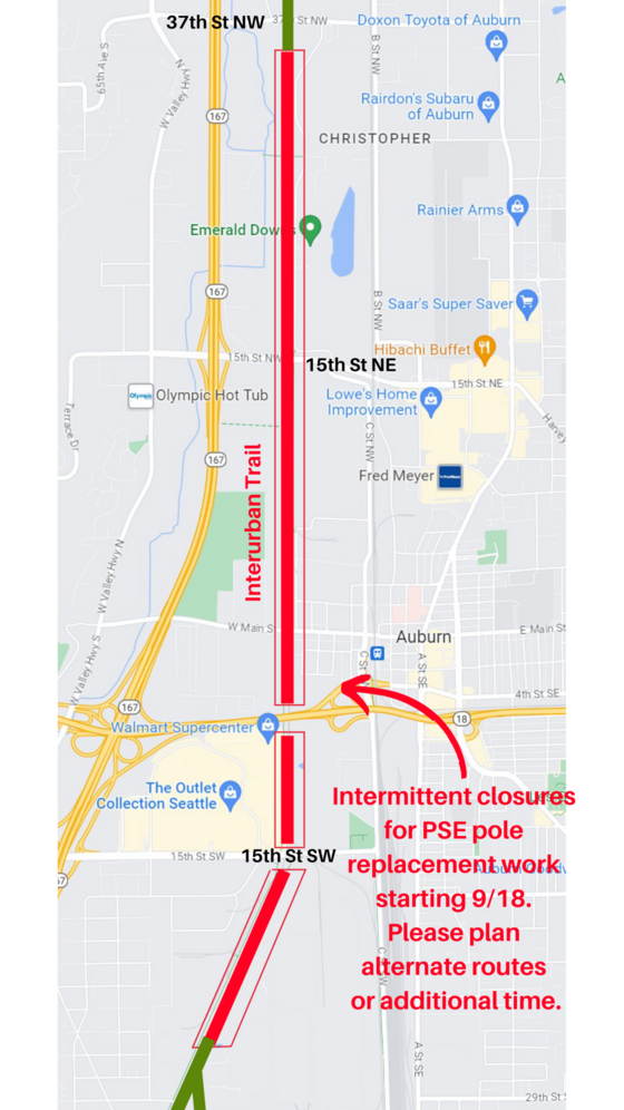
Starting today, Puget Sound Energy crews will be working along the Interurban Trail between 37th Street NW in Auburn and the Boeing Auburn facility near 5th Ave N in Algona. The trail should generally be open, but crews will close it as needed while installing utility poles. Flaggers will instruct trail users on what to do.
Unfortunately, there’s no schedule for when these closure will occur, and there is no established detour route. PSE also does not yet know when construction will end.
My biggest concern would be any closures near SR-18 where the alternatives to the trail are extremely concerning. C Street, the nearest detour option, is a scary mess of freeway ramps that is not bike-friendly. There is a skinny and almost hidden walking path squeezed between the highways ramps and the railway that connects a bus stop on C Street south of SR-18 with the Sounder Station parking lot north of the highway, but I’m not confident trail users would find this without the help of detour signage. Even if a rider does find this path, there are still significant challenges for navigating back to the trail that I’m not sure people will find on their own without help or previous knowledge of the area. I strongly suggest that PSE crews never fully close this part of the trail. Holding folks for a few minutes until flaggers can let them through safely would be much better than sending people on a very dangerous mission to find a way to cross SR-18. If a closure cannot be avoided, trail users will need assistance finding a reasonable detour.
As a side note, perhaps it should not be this dangerous and confusing to walk or bike across SR-18.
The first I heard of this work was from a recent phone call from a reader who noticed some markings on the trail but was having trouble figuring out what was going to happen. I didn’t receive an official notice of the work until Friday afternoon for work scheduled to begin Monday morning (today). This does not give people enough time to plan, and it also does not give folks the time needed to work with PSE to find a workable detour plan.
Due to public safety, sections of trail where crews are working will be closed when setting poles or moving trucks/equipment. Flaggers will be on the trail to direct people around the work area. No detours are available, but the trail will remain open when not actively installing poles.
Please follow all posted signs and directions from crews. Plan for extra time and/or alternate routes. We will share construction end dates as soon as they become available.