— Advertisement —
  • Bus-bike-backpacking on the Iron Horse Trail is simply unreal

    IMG_2183It’s early on a Friday morning, and we’re waiting at 4th and Lenora, an unassuming corner in downtown Seattle where so many great bus-bike adventures begin. This is the first stop for Sound Transit’s 554 express bus to Issaquah. Within hours, we’d be deep in the Cascade mountains with few other humans in sight except for fleeting glimpses of I-90, which washes the mountainside with white noise.

    We live in a place where you don’t need a car to get the hell outta town. And though Seattle is surrounded by car-free getaway options, the Iron Horse Trail is an unparalleled resource so magnificent I can still hardly believe it’s real.
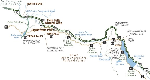
    Iron%20Horse%20West%20full%20color%20Map%20FINAL%2007-30-14_201407311724353302-1Iron Horse State Park is a very long linear park following a decommissioned stretch of the Chicago, Milwaukee, St. Paul, and Pacific Railroad (AKA the “Milwaukee Road”). That rail line and its amazing series of tunnels and bridges — not to mention it’s gentle railroad-grade incline — now caries a gravel biking and hiking trail called the John Wayne Pioneer Trail, though many people refer to it as the Iron Horse Trail. The state park has developed a section about 110 miles long from Rattlesnake Lake to the Columbia River, but the rail right-of-way stretches 253 miles to the Idaho border (some sections are more developed and complete than others. Check out this great trip report from 26inchslicks for info about the full route).

    Getting there from Seattle without a car

    (more…)

    — Advertisement —
  • 75 neighborhoods turn boring streets into Play Streets, city renews program pilot

    Screenshot from SDOT video (watch below)
    Screenshot from SDOT video (watch below)

    There is only one space that truly connects every home on a block: The street.

    For a generation or two, most streets have been surrendered to the movement and storage of cars. Kids are taught to be afraid of streets and to stay out, as though there were an alligator pit between them and their friend’s house.

    Play Streets turn all of that on its head. For absolutely zero dollars, anyone can apply to turn one block of residential street into a city-sanctioned Play Street either as a one-time event or on a regular basis. In the first year, 75 different blocks across the city have taken advantage of the program. That’s pretty impressive considering the program has done very little advertising, relying mostly on word-of-mouth.

    The program has been renewed for another year, SDOT announced this week. So get your neighbors together and transform your street into a playground and community gathering space.

    SDOT recently put together this video to help explain what a Play Street is. Could be useful to show your skeptical neighbors: (more…)

    — Advertisement —
  • 2-year-old killed in Redmond was 2nd toddler in a week to die on a King County street

    Screen Shot 2015-07-06 at 12.06.21 PMSusie Dreher “was a uniquely joyful human from the moment she emerged,” according to a piece of writing no family should ever need to craft: An obituary for their two-year-old killed in traffic.

    We offer her family our deepest condolences.

    Susie was killed when she ran from a play area in the Redmond Town Center shopping area. A 25-year-old driving east on NE 75th Street struck her at the intersection of 164th Ave NE. Redmond Police said in a release that their “investigation reveals the driver did not have an opportunity to see the child or to stop in time.”

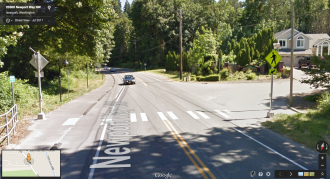
    The intersection where the collision occurred, from Google Street View.
    The intersection where the collision occurred, from Google Street View.

    The tragedy came just days after a four-year-old was killed in an Issaquah crosswalk. (more…)

    — Advertisement —
  • The magnificent new UW Burke-Gilman Trail opens

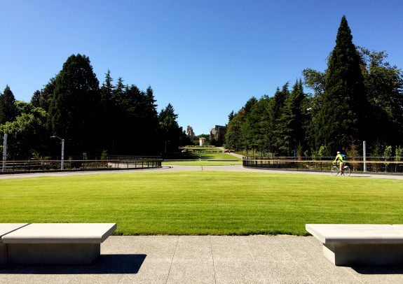
    IMG_2158

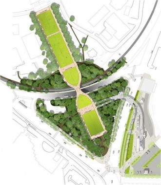
    Through-traffic is routed under the new parklike space while station and Montlake Bridge traffic is routed through the park.
    Through-traffic is routed under the new parklike space while station and Montlake Bridge traffic is routed through the park.

    After a year and a half of ever-changing detours, one of the busiest sections of trail anywhere in the State of Washington (and maybe the entire country) reopened Wednesday afternoon.

    The completely redesigned “Rainier Vista” area has a much grander, people-focused feel with wide pathways, sprawling lawns and park benches. It is very easy to imagine people hanging out here in big numbers, especially when UW classes are in session. Much like Cal Anderson Park on Capitol Hill, it’s a simple, comfortable place to just enjoy being in Seattle.

    And true to its name, it has a spectacular view of Mount Rainier.

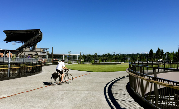
    IMG_2151
    iPhone cameras are wide-angle, so Rainier always looks way less awesome than it does in real life. It’s just one more of her magical powers: She only poses for high quality cameras.

    (more…)

    — Advertisement —
  • Our latest look at plans for a new downtown waterfront

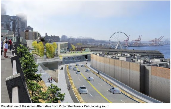
    AWPOW_DraftEIS_June2015-elliottwayThe draft Environmental Impact Statement for the redesigned Seattle downtown waterfront is out. You have until August 12 to submit comments, which you can do via this online survey or by emailing [email protected]. The final EIS should be out in late 2015 or early 2016, and construction should be ready to begin in 2017.

    There will also be a public meeting 4:30–7:30 p.m. July 22 at City Hall.

    The plan still includes a 12-foot protected bikeway on the west side of the new Alaskan Way, separated from the sidewalk, bus stops and general traffic. It also includes quality protected bike lanes on the new Elliott Way, which will climb the hill from Alaskan Way to connect to Elliott and Western Avenues. Removing the viaduct will allow for all kinds of new connections in this part of Belltown.

    The roadway is still very wide with a ton of lanes to cross, especially on the south end between the ferry terminal and King Street. It’s great that most the lanes are 10 or 11 feet, since studies have shown wider lanes encourage speeding and increase collisions.

    But people on foot and bikes crossing from Pioneer Square to the ferry or waterfront will still have to traverse up to 88 feet of traffic lanes. Among older populations, for example, a walking speed of 3.3 feet per second is common (PDF). At that speed, it could take nearly half a minute just to walk across all these lanes of traffic. That’s a long time to be exposed in front of traffic, and such width makes it a lot easier to get caught halfway when the lights change.

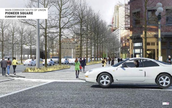
    This glossy concept image from a late 2014 Design Commission presentation conveniently doesn't pan any further left to see how wide this street really is
    This glossy concept image (Alaskan Way at Main St) from a late 2014 Design Commission presentation conveniently didn’t pan any further left to show how wide this street really is

    The study includes significant analysis of the motor vehicle level of service, but nearly nothing for pedestrian level of service even though it predicts more people walking across the street than vehicles driven on it during summer days.

    Since walkability is clearly secondary to motor vehicle throughput goals in these designs, we referred to this previously as a surface highway to complement the tunnel highway. It might be an acceptable design if the tunnel were not being built (or if we choose to abandon the tunnel), but it’s way overbuilt as an addition to the tunnel.

    Here’s an updated look at how the viaduct-free waterfront street design is shaping up: (more…)

    — Advertisement —
  • Woman kills 4-year-old walking in Issaquah crosswalk

    Image of the intersection from Google Street View.
    Image of the intersection from Google Street View.

    A 67-year-old woman struck four-year-old Haochen Xu while he crossed in an Issaquah crosswalk with his mother Friday. Sadly, he died the next day in the hospital.

    Our deepest condolences to his family.

    A roadside memorial has been set up at the crosswalk, according to Issaquah Reporter.

    Issaquah Police and the Washington State Patrol are still investigating. The woman driving remained at the scene and was not found to have signs of impairment.

    “For some reason, the driver just failed to see them,” Issaquah Police Commander Stan Conrad told the Issaquah Press. The boy’s mother was just steps behind him, pushing his bicycle.

    But neighbors have been asking for safety changes on this street for years, and now they’re demanding changes. An online petition clearly lays out the problem and some possible solutions (see text below, then go sign it). No action is not one of the options. Hundreds have already signed. (more…)

    — Advertisement —
— Advertisement —

Join the Seattle Bike Blog Supporters

As a supporter, you help power independent bike news in the Seattle area. Please consider supporting the site financially starting at $5 per month:

Latest stories

— Advertisements —

Latest on Mastodon

Loading Mastodon feed…