— Advertisement —
  • City proposes ‘massive’ Pronto Cycle Share expansion

    1App-servicemap
    Images from the city’s 2015 TIGER grant application.

    Pronto Cycle Share is an amazing transportation tool, but only if it’s limited service area fills a hole in your specific trip. If you live in the service area, it’s amazing. If you are headed to a city center destination that is an awkward distance from an express transit route, bike share can be a fast and easy way to cover that last piece of your trip.

    But the biggest problem with Pronto is that the service area is simply too small to meet most people’s needs. And under the current business model, the system would expand slowly over time as more private sponsorship investments or city budget line items lead the way. It’s a plan that creates solid benefits for relatively little public investment, but it’s not a plan that can truly revolutionize transportation and low-income access to bicycling in Seattle.

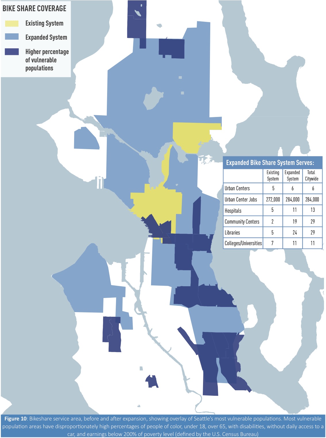
    That’s why the city has put together a visionary plan for a massive, fast expansion of Pronto that would increase the service area from five square miles to 42 square miles, reaching from Northgate to Rainier Beach to Alki. The number of stations would increase from 50 to 250, and the percentage of Seattle residents within walking distance of a station would go from 14 percent to 62 percent.

    “Having a massive expansion of the bike share will make it really functional public transit,” said SDOT Director Scott Kubly. “Bike share is a great way to expand the reach of transit” because it helps connect more homes and destinations within reach of a high-quality express transit route. It’s a way to fill the “last mile” and “first mile” problems of transit trips, where slow local buses or long transfer waits make transit use less appealing and effective.

    On top of all this, the city would also roll out electric assisted bikes in the fleet, which will be especially helpful for stations in very hilly areas and for users who have trouble climbing hills or going longer distances.

    The e-bikes “will effectively flatten the city,” said SDOT Director Scott Kubly, and “open it up to people of different ages and abilities and different levels of fitness.” Kubly said studies looking at the effect of e-bikes in Norway showed that people took 50 percent more trips and traveled distances twice as far, an effect more pronounced in women.  (more…)

    — Advertisement —
  • County will close Green River Trail in sections this summer

    green-river-levee-maintenance-site-map-may2015 copyIn the past decade, the Green River Trail has been closed as often as it has been open. And just when you thought it might finally be fully open, King County has announced another series of closures through the end of the year and maybe even continuing into 2016.

    The trail provides crews access to work on the levy, which is obviously important work. But this trail — which provides a rare safe biking and walking connection in south King County — has been closed so often that it is simply undependable as a transportation route.

    Adding to the problem, King County will not guarantee trail detours. Sometimes you’ll get a detour, sometimes you’ll be spit out onto dangerous streets without any help. The lack of a safe detour option is also a problem for people who depend on the Snoqualmie Valley Trail, as we reported recently. A reader who depends on that trail to commute summed up her frustration with the lack of detour this way: (more…)

    — Advertisement —
  • Finally, movement on court-required Missing Link study + 98.6% voice support for trail

    After somehow spending a year and a half to “finish analyzing the feedback from the EIS scoping process held in late 2013,” the city is holding an open house to present the plan to develop a study of options to finally complete the Ballard Missing Link of the Burke-Gilman Trail. The draft of that study won’t be out until 2016.

    In the meantime, the city had to return a $1 million Federal Highway Administration grant and a $500,000 WA State Safe Routes to School Grant it had won for the Missing Link due to lack of progress on the project. The cost of the completely absurd amount of delay on this trail boggles the mind. What’s even more maddening is that 98.6 percent of people who responded to the 2013 outreach process voiced support for completing the trail. No, I didn’t typo that number. More on that below.

    The open house is 6–8 p.m. June 18 at Ballard High School. More details from an event flier:

    BGT ML open house invite

    The most unnecessary study in Seattle history

    (more…)

    — Advertisement —
  • Huge support for safe streets at Move Seattle hearing + Need to focus on vision rather than costs

    Morgan Scherer of Family Bike Seattle testifies at the hearing. With her: Margaret McCauley and kids
    Morgan Scherer of Family Bike Seattle testifies at the hearing. With her: Margaret McCauley and kids
    The call for safe streets during Tuesday’s public hearing on the Move Seattle levy was overwhelming. Indeed, as person after person and family after family got up to advocate for safe streets in their neighborhoods, I kept waiting for someone to get up and argue against the safety goals of the Move Seattle plan. But through hours of testimony it basically didn’t happen (watch the whole thing below).

    Certainly, a big reason for the overwhelming support for safe streets was organizing efforts by Seattle Neighborhood Greenways and Cascade Bicycle Club. But these were neighbors who volunteer their time to the cause of making the neighborhoods safer and more accessible for people walking and biking. They’re people who believe in the vision of having a city with Safe Routes to School, with priority given to schools with high rates of poverty.

    But not only do they believe in this vision, it now feels tantalizingly within reach. That’s why people are so motivated to spend their Tuesday waiting their turn for two minutes at the mic in front of the entire City Council.

    The Move Seattle levy would raise $930 million over nine years. This is much bigger than the $365 million Bridging the Gap measure that expires at the end of the year. But the Move Seattle vision is so much more inspiring, and it’s clear that with all the transportation woes in a growing Seattle, Bridging the Gap simply wasn’t big enough or forward-thinking enough to meet our city’s needs.

    Doing nothing or just doing more of the same will never get Seattle caught up on it’s maintenance backlog, transit capacity needs and lacking safe walking and biking options. (more…)

    — Advertisement —
  • WA Bikes: Write legislators to make sure vital bike/walk funding stays in the transpo bill

    Image from WA Bikes, included in their call to action
    Image from WA Bikes, included in their call to action

    Did you know the Washington State Legislature is still in session?

    It is! And they are still working through the details on a 16-year transportation funding package.

    We’ve already reported on the modest funding for Safe Routes to School and other bike/walk safety and access projects working through the legislature. It’s pennies compared to the $8.3 billion for highways, but it’s more than usual. And it’s always at risk until it’s final.

    So WA Bikes wants you to contact your legislators to tell them to stand up for the $236 million included in the House version of the bill. Even if you don’t support the whole package, we need to make sure as much bike/walk funding as possible is included if it does pass. WA Bikes even has this handy tool to help you contact them. Below is the sample text of a letter they want you to send: (more…)

    — Advertisement —
  • New app from Cascade guides you on popular area bike rides

    Looking to get out and, I don’t know, just ride SOMEWHERE?

    Well, Cascade Bicycle Club has released a snazzy new iOS app that features ten rides in and around Seattle “curated by Cascade staff.” From long rides — like the Lake Washington Loop — to short rides — like from the Space Needle to Pioneer Square and back — the Let’s Ride! app includes a turn-by-turn cue sheets and summaries of how difficult the rides are and how long they will take to complete.

    One ride even features a backdrop of yours truly smiling like a doofus. NO OTHER APP HAS THIS:

    IMG_1856Here’s a map of ride starting points (obviously, the loop rides can be started at any point): (more…)

    — Advertisement —
— Advertisement —

Join the Seattle Bike Blog Supporters

As a supporter, you help power independent bike news in the Seattle area. Please consider supporting the site financially starting at $5 per month:

Latest stories

— Advertisements —

Latest on Mastodon

Loading Mastodon feed…