— Advertisement —
  • Watch: An analysis of the 2015 Ride the Ducks tragedy on the Aurora Bridge

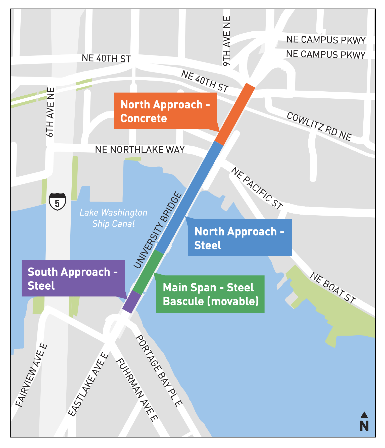
    Nearly eight years after the Ride the Ducks tragedy on the Aurora Bridge, YouTube channel Brick Immortar recently released a detailed walkthrough of the event, including the history of the vehicles and details from the NTSB investigation’s report. It is tough to revisit the tragedy, but it’s important that we understand as a society how something like this could happen so that we can make sure it doesn’t happen again. It wasn’t just about a cracked axle housing on one vehicle. The axle crack was the result of a company that did not have an appropriate culture of safety, which is why these vehicles were responsible for a completely different kind of mass-death event just a few years later in Branson. If any priority other than safety takes precedent in a transportation operation, this is what can happen.

    Thankfully, Ride the Ducks shut down in Seattle back in 2020, and good riddance. They never should have returned to Seattle’s roads and waterways after that horrible day in 2015 when a mechanical failure caused the amphibious vehicle’s driver to lose control and crash into the side of a tour bus filled with international students from North Seattle College. Because of the pointed and elevated front end of the DUKW, it sliced into the side of the bus at the same level as the passenger seats. Five people were killed on the bus and 69 others were injured among all vehicles involved, many very seriously. This single crash was responsible for 25% of all traffic fatalities on Seattle streets that year. September 24 will mark the 8th anniversary of this tragedy.

    The legacy of the Seattle tragedy was made even worse when Federal lawmakers and regulators failed to ban these DUKW vehicles across the nation, leading to a 2018 disaster in Branson, Missouri, in which 17 people drowned when one of them sank. The company disregarded a weather report that should have scuttled the floating portion of the tour. They had also installed a canopy over the top of the passenger area, which prevented people from escaping when the vehicle began to sink. Passengers were also not required to wear life vests, and the vests on board were clearly not accessible quickly enough in the event the vehicle took on water. A series of lawsuits on behalf of victims were settled for undisclosed amounts, but the Missouri Attorney General has filed criminal charges against three employees. An effort to pass Federal legislation all but banning DUKW nationwide did not succeed, but negative press and major lawsuits have since closed all Ride the Ducks operations in the US (Boston Duck Tours, which uses different branding but similar vehicles, is still operational somehow).

    (more…)
    — Advertisement —
  • North U Bridge project is a huge opportunity for a safer and better-connected U District + Survey

    Project area map showing the north approach is the section between pacific and 40th.
    The North Approach is the section in need of rehab or replacement. Map from the project website.

    Most of the University Bridge is in decent condition, but the northernmost section between NE 40th and NE Pacific Streets needs major rehab or replacement, according to SDOT. The 1930s concrete structure is at the end of its life, and that may be for the best because it no longer fits into the U District of today.

    SDOT is currently conducting an online survey for the project, and you should definitely complete it. In the further thoughts box, I wrote, “Remove highway-style interchanges and connect southbound and northbound bike lanes to the Burke-Gilman Trail.”

    The city currently only has funding to begin a study of the bridge replacement and rehab options. Funding for work will need to come from either grants or perhaps the city’s yet-to-be-created 2024 transportation funding package.

    Archive black and white aerial photo of the University Bridge and nearby area, which was mostly filled with parked cars and industrial uses.
    1959 photo of the University Bridge area following completion of an 11th Ave NE widening project. I-5 Ship Canal Bridge supports are visible in the background, though the freeway did not fully open until 1967. Land use around the U Bridge was very different from today. Photo from the Seattle Municipal Archive.

    Considering the early stage and undetermined funding source for the work, I would push the city to expand the project scope to also include the area directly north of the bridge structure itself. Remember that these bridge and road connections were designed when there were some major differences compared to today. For example, I-5 did not yet exist, so Roosevelt and 11th were intended to be a north-south backbone roadway for the whole region in a way that simply is not relevant anymore. Another huge difference is that what is now the Burke-Gilman Trail was still an active railroad back then. Because of this, the whole area was designed under the assumption that people would need to avoid what is now a major regional biking and walking trail. The city should be working to build seamless and intuitive connections between the bridge and the trail for people heading in all directions. This project may be the best possible opportunity to rebuild this infrastructure in a way that makes sense for today’s U District.

    (more…)
    — Advertisement —
  • My book release party is August 28 at Elliott Bay Book Company

    Selfie of Tom Fucoloro holding a copy of Biking Uphill in the Rain while standing in front of UW Tower.

    I finally got the chance to hold an advance copy of my book Biking Uphill in the Rain: The Story of Seattle from behind the Handlebars, and it was a bit surreal. As soon as I got word that advance copies had arrived, I walked over to the press office inside UW Tower to get one. This thing has been coming together in my head and in various text documents for 4 years, but now it’s a real thing. It has an ISBN. I have an ISBN! The former used book store clerk inside me is giddy to know that book store and library workers all over will be punching 9780295751580 into their tenkey pads and finding me (and hey, do me a solid and put it on one of the highlight shelves, maybe like a mid-autumn hygge display because it has the word “rain” in the title).

    If you want a copy, you can preorder it today from my publisher University of Washington Press. Or you can join me for the book release 7 p.m August 28 at Elliott Bay Book Company on Capitol Hill. I will gladly sign your copy, of course.

    Event image from Elliott Bay Book Company with author photo of Tom and text: Monday 8/28, 7pm.
    (more…)
    — Advertisement —
  • Ballard Ave changes should make it a little easier to bike southbound

    The Ballard Ave Café Street project has been an iterative series of changes since 2020 designed to expand outdoor space for businesses, including lots of outdoor seating for restaurants and bars. To make it happen, SDOT made the street one-way for cars and limited parking. Now the city is preparing the next phase of changes, which could make things a bit better for walking and biking.

    While the basic goals of project’s phase 1 were good, there was one big issue: By making the one-way northbound travel lane relatively skinny, the project made it very difficult for anyone on a bike trying to head south through the business district. The only parallel route options are Shilshole Ave NW and Leary Way NW, both of which are famously unfriendly to people on bikes. There are also no signs helping people on bikes figure out what to do, leaving people wondering if they are even allowed to bike the wrong way. But surely the city doesn’t want people to bike on the busy Ballard Ave sidewalks, right? It feels like people on bikes were just completely forgotten about, which is not the welcoming and comfortable experience that the café street is supposed to create. And unlike Pike Place, the single traffic lane on Ballard Ave still feels like a cars-first space rather than a shared space.

    I asked people on social media how they ride south through the Ballard business district, and nearly all said they ride the wrong way on Ballard Ave (though a few said they ride on Shilshole). This is also what I do, though it does not feel comfortable. I suspect some people simply avoid the area now, which is too bad since a project like this thrives on people arriving by walking, biking and taking transit.

    Overhead graphic showing the design plan with expanded walking areas.
    The Phase 2 design plan, from the project website.
    (more…)
    — Advertisement —
  • Alert now-Spring 2024: I-90 Trail detour in Factoria

    Screenshot of a tweet from WSDOT with a map of the closure and text: Bicycle Emoji, Long-term closure of the Mountains to Sound Trail in Bellevue starts Monday and will last into spring 2024. Between 132nd Ave SE and just east of Sunset Ravine. Signed detour uses sidewalks along SE 36th Street. Work is par of I-90 Sunset Creek fish passage.
    The alert from WSDOT.

    Well, I hope you enjoyed that new section of the I-90 Trail in Factoria, because a section of it will be detoured to the other side of SE 36th Street until Spring 2024.

    As part of work on the really cool I-90 Sunset Creek Fish Passage project, crews will be detouring the I-90 Trail between the existing crosswalks at 132nd Ave SE and the crosswalk near the Kaiser Permanente Factoria Medical Center. That’s not so cool. There is skinny painted bike lane on 36th in the eastbound (uphill) direction, but westbound riders will have to choose between riding with mixed traffic or riding on the sidewalk, neither of which are great options. The official signed detour will direct riders to the sidewalk. SE 36th Street will also be reduced to “a single-lane of alternating traffic” at some point, so it’s unclear how bike-friendly the on-street options will be.

    News of the Monday detour came as a surprise when WSDOT sent out their hand-drawn map in a tweet 6 p.m. Friday evening. That was the first I had heard about the project having an impact on the trail, and the project website does not mention the trail anywhere. I am on every imaginable local transportation email list, and a search showed that this trail impact was never sent out to any of them. I did find 2 emails mentioning the Sunset Creek project, but neither mentioned an impact to biking or the trail. It seems like the trail detour was either forgotten or ignored, which is frustrating. This is a major regional trail, and it really should not be treated as an afterthought like this.

    Concept overhead graphic of the planned Sunset Creek passing under the roads and freeway. The trail is not pictured.
    This concept graphic from the project website does not show the I-90 Trail.
    (more…)
    — Advertisement —
  • MLK Jr Way bike lane construction to start in fall, includes crosswalk improvements at Rainier Ave intersection

    Overview map of the MLK Jr Way Safety Project.

    After a delay finalizing the construction contract, SDOT is planning to begin work on the MLK Jr Way Safety Project in the fall. The project includes protected bike lanes from Mount Baker Station to S Judkins Street and includes significant safety improvements for everyone passing through the monstrous intersection with Rainier Ave S.

    The project was selected after a huge amount of community organizing as well as consistent urging from the Seattle Bicycle Advisory Board pushing the city to prioritize bike safety projects in the south end. And while the first maps showed the project ending before the intersection with Rainier Ave, the project now connects through the intersection to S Winthrop Street, providing a complete connection to Mount Baker Station. But perhaps even more importantly, the Rainier/MLK intersection changes will also add significant curb extensions to slow turning cars and add much-needed crosswalks between the light rail station and Franklin High School. At long last, all four legs of the intersection will have a crosswalk, doubling the current number. Honestly, these crosswalk improvements might be the most impactful and important elements of the whole project.

    Overhead diagram of the MLK and Rainier intersection design plan, including expanded sidewalk space and curb extensions as well as crosswalks for all four corners.
    (more…)
    — Advertisement —
— Advertisement —

Join the Seattle Bike Blog Supporters

As a supporter, you help power independent bike news in the Seattle area. Please consider supporting the site financially starting at $5 per month:

Latest stories

— Advertisements —

Latest on Mastodon

Loading Mastodon feed…