— Advertisement —
  • Final Westlake Bikeway open house is Wednesday + A look at updated plans

    From a September 30 presentation to the Design Advisory Committee (see all documents here)
    From a September 30 presentation to the Design Advisory Committee (see all documents here)

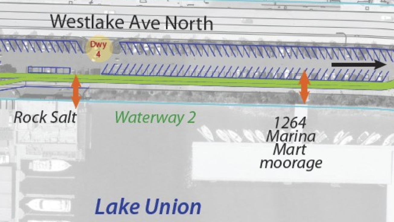
    The city is just about ready to show off its design for the Westlake Bikeway after many community meetings big and small and more than a year and a half of debates about the plan to provide a safe space for people to travel between South Lake Union and the Fremont Bridge through the giant, endless parking lot along the edge of the lake.

    It’s been a long and messy road, and the city has brought a whole lot of people to the table to express concerns, propose alternative ideas and guide the design. The result is a safer, protected bikeway along the eastern edge of the parking lot and a redesigned and more efficient parking area tuned to the success of businesses rather than acting as free all-day parking for city center employees trying to get around paid parking at their workplaces.

    You can check out the plans and give SDOT feedback during an open house from 5:30 – 8 p.m. Wednesday at Fremont Studios (35th and Phinney). The presentation starts at 6:15. There will be activities for kids, so bring ’em with you.

    And despite all the meetings the city has already held, people still need to show up and support a safer Westlake for everyone. The exact design the city plans to unveil Wednesday is not yet clear, but a recent presentation to the Design Advisory Committee gives a hint of what to expect: (more…)

    — Advertisement —
  • Here are the projects at the top of the city’s Bike Plan to-do list

    BMP Implementation Plan 2015-mapSo, Seattle passed a 20-year Bike Master Plan. Now what?

    Well, SDOT planners need to figure out which projects rise to the top of the priority list. The city has released its delayed Bike Master Plan Implementation Plan (AKA the Bike Plan Plan). This document runs the Master Plan through a prioritization framework that weighs segments based on these criteria:

    • Safety – 40 points
    • Connectivity – 25 points
    • Equity – 20 points
    • Ridership – 10 points
    • Livability – 5 points

    The result is a list mostly made up of protected bike lanes and neighborhood greenways. For example, the plan includes 7.1 miles of protected bike lanes and 12.1 miles of neighborhood greenways in 2015.

    However, the biggest limit to implementing the plan is, of course, funding. And with the Bridging the Gap property tax levy scheduled to expire at the end of 2015, the Bike Plan Plan has to assume that there will not be a new source of transportation funding to replace or expand on it. So the budget lines (and, therefore, bike facility miles) for 2016 through 2019 are very underwhelming. (more…)

    — Advertisement —
  • Chicago’s streets feel less mean when you’re on a Divvy bike

    IMG_0170I have been out of town since Seattle’s bike share system launched, so to deal with my intense Pronto jealousy I had to check out some Divvy bikes while in Chicago.

    I grew up in St. Louis and went to college in Illinois, so I have been to Chicago a fair number of times. But I have never had this much fun getting around town, and I have definitely never had this clear of a picture of the city’s geography. For the first time, I actually think I know where I am most the time, and it’s all thanks to bike share.

    Biking around also had a very unexpected side-effect: The city feels a lot less mean. At first I was a bit intimidated by the idea of biking in this sprawling car-filled metropolis, but once I got on the bike the city softened. Quality bike lanes like the ones on Dearborn through the heart of the Loop and the fantastic Lakefront trail definitely helped, but somehow I feel even more comfortable biking around Chicago than I do trying to navigate on foot and transit (and way more comfortable than driving a car here, which is terrifying).

    Unlike in Seattle, Chicago does not have helmets available at bike share stations. Like most of you, I am so accustomed to wearing a helmet when I bike that I feel a little naked if I don’t have one. In fact, I drive so rarely that I have even started to feel a bit naked when I get in a car without a helmet.

    But for the most part, it did not feel dangerous to ride a Divvy without a helmet, especially in the city center and on streets with good or decent bike lanes. The bikes are so upright, heavy and slow that I just didn’t feel threatened. And people who drive (except for one jerk) sure give Divvy riders a lot of space, something I was not expecting in a city where people drive so aggressively it can feel like you’re playing chicken every time you try to merge onto the freeway. (more…)

    — Advertisement —
  • So, Pronto is a few days old. How’s it going?

    From Oliver O'Brien's bike share visualizer. Screenshot taken at 10:35 a.m.
    From Oliver O’Brien’s bike share visualizer. Screenshot taken at 10:35 a.m.

    So, I’m still out of town (in Chicago now), so I still have not ridden a Pronto bike. And to think I call myself a bike blogger!

    Now that you’ve had a few days to get used to the system, how are things going?

    Looking at bike distribution data, it does not appear that there are any critical unbalancing issues yet. For example, there are fewer bikes at Capitol Hill stations fewer empty docks downtown as of late morning on a work day, which is exactly what you’d expect. But so far, no stations are completely full and no Capitol Hill stations are completely empty (the only empty station is on the edge of the service area near Key Arena).

    Oliver O’Brien’s bike share tracking website is a great tool to visualize bike distribution, as is the official Pronto station map. The Spotcycle mobile app is a great way to make sure your dock has a bike for you when you’re on the run. If you want to use Pronto data in your app or project, here the link to the feed (at I think so, I don’t know what any of it means).

    One size never fits all

    (more…)

    — Advertisement —
  • City moves dangerous Ballard Bridge sign + Peddler Brewing tells KIRO 7 why a change is needed

    Photo from Seattle Traffic Engineer Dongho Chang
    Photo of fixed sign placement from Seattle Traffic Engineer Dongho Chang

    Biking over the Ballard Bridge can be a stressful and squished experience. The sidewalks are far too skinny to squeeze by others as it is. So when road crews installed a sign warning drivers of changes dues to the W Emerson Overpass Repair Project in such a way that it blocked part of the already-too-skinny sidewalk, several of you emailed me and the city to voice your frustration.

    Auden Kaehler put it this way:

    As one of many cyclists who depend on the Ballard Bridge to commute to/from work I, and my fellow cyclists, were shocked yesterday morning to see city workers installing traffic detour posts on the West side approach sidewalk, which is already unacceptably narrow.

    The city listened to Kaehler and moved the sign to get it out of the way of the sidewalk. City Traffic Engineer then sent the photo above to Kaehler and Seattle Bike Blog. Road workers placing signs in bike lanes and sidewalks is a pervasive issue, but it’s great to see the city respond so quickly.

    Haley from Peddler Brewing talks Ballard Bridge with KIRO 7

    (more…)

    — Advertisement —
  • Bike News Roundup: How to build a bike lane on a bridge

    It’s time for the Bike News Roundup! Set your browser to time theft mode.

    First up, I did not include this video in the last Bike News Roundup, and there was almost a popular uprising against me. So here it is. Please end the sit-in at my house.

    (more…)

    — Advertisement —
— Advertisement —

Join the Seattle Bike Blog Supporters

As a supporter, you help power independent bike news in the Seattle area. Please consider supporting the site financially starting at $5 per month:

Latest stories

— Advertisements —

Latest on Mastodon

Loading Mastodon feed…