— Advertisement —
  • Action alert from People For Bikes: Treat e-bikes like pedal bikes in National Parks

    A person walks a bike across a makeshift wooden bridge over a creek.
    Navigating a washed-out section of the Carbon River Road in Mount Rainier National Park in 2017.

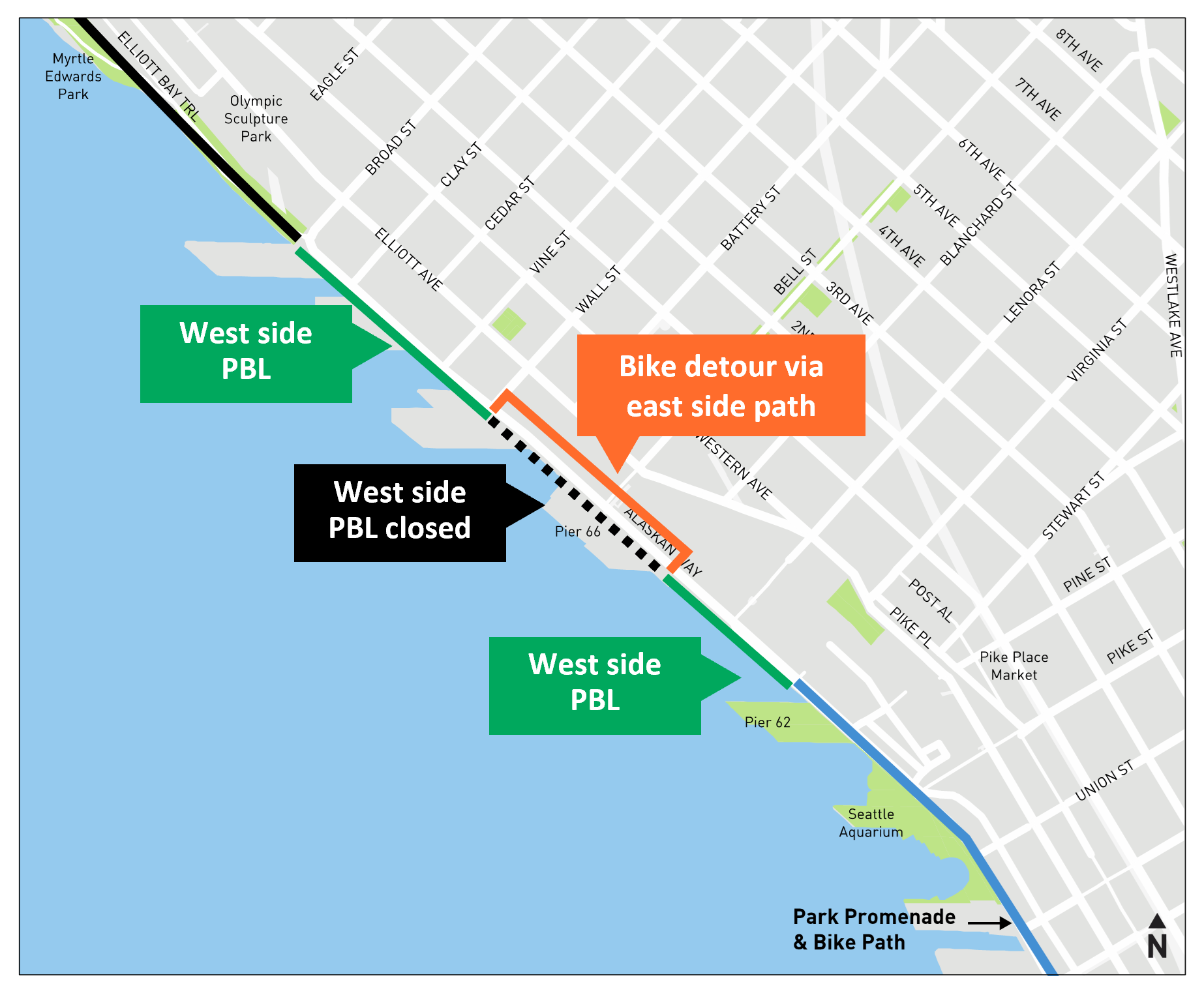
    People For Bikes, the national advocacy organization, has put out an action alert urging people to support a rule change that would give superintendents of National Parks “greater authority to allow the use of e-bikes wherever traditional bicycles are currently allowed.”

    Many National Parks are typically already rather restrictive about bicycle access, so this rule change would not mean people could suddenly go e-biking wherever they want. Instead, it would allow e-bikes to be treated like a pedal bike “unless superintendents determined that restrictions or closures of certain areas were warranted after taking into consideration public health and safety, natural and cultural resource protection, and other management activities and objectives,” according to the official environmental assessment of the proposed rule change (PDF).

    National Parks are very different from each other. Most people probably think first of the wilderness areas and geographic wonders, but some National Parks are within urban centers. It makes sense to put this level of decision in the hands of superintendents who are familiar with each individual park’s needs. Aside from some extreme exceptions (very technical mountain biking is a possible example), e-bikes fit in just fine with pedal-only bikes, especially Class 1 and Class 2 e-bikes. The new rule includes definitions for the different e-bike classes, so a superintendent could presumably ban Class 3 e-bikes (can be powered up to 27mph) but allow the more common Class 1 and 2 bikes (powered up to 20 mph).

    You can submit a comment in support of the change by July 21 using this online form. People For Bikes wrote this sample language you can use or modify for your comment:

    (more…)
    — Advertisement —
  • Biking the new North Lake Washington Trail Loop

    My family and I biked the new North Lake Washington Trail Loop Saturday, and it was amazing. It is an instant classic of a bike ride with wide appeal. I suspect it will supplant the always popular Seattle-to-Woodinville-and-back ride since riders can now complete the loop rather than backtrack on the Sammamish River and Burke-Gilman Trails. The Totem Lake Connector bridge was the final* major piece needed to make this trail loop fully functional, so the bridge opening celebration Saturday also felt like a celebration for this whole loop. (*As you will see in the photos below, the Eastrail crossing at 132nd Ave NE desperately needs a fix, but I still feel comfortable recommending the loop despite this problem spot.)

    Of course, Seattle Bike Blog mostly focuses on bicycling for transportation, and these new trail opening connect many more homes and workplaces to a bike route that is faster, easier, safer, or all of the above.

    But in this post, I am focusing on the recreational aspect because a major new loop of this significance is extremely rare. The ride it will widely replace (or, rather, build upon) has been a mainstay of trail riding in the area since the Sammamish River Trail and the Burke-Gilman Trail were connected in 1993. It’s a shade over 32 miles long, and Google Maps estimates a little over 600 feet in total climbing. For a bike ride loop of that length in this glacier-carved region, that’s just about as flat as you can get (I can’t think of a flatter trail loop, can you? Let us know in the comments below).

    Map of the route via Google Maps.
    Map of the route recreated using Google Maps. Google does not yet have the Totem Lake Connector working, but you get the idea.

    I suspect this loop will be many people’s first ever long bike ride, and they are going to love it. It’s got enough challenge to push people’s limits, but it is also peppered with parks, restaurants, breweries and wineries. So you could ride for 3 hours straight, or you could make a day of it and stop as often as desired. UW Station also serves as a fantastic start and end point, providing excellent regional transit access to this trail loop via both light rail and UW-bound bus routes.

    The ride

    We started our journey in the U District. Though the Burke-Gilman Trail is well-known, it was a really cool feeling to set out on this familiar trail knowing there were places ahead I had never been. I was also very excited to show my five-year-old some new areas and parks she has never seen.

    Selfie of the author with spouse Kelli and child on a cargo bike behind him on a trail.
    (more…)
    — Advertisement —
  • Saturday: Totem Lake bridge will connect Eastrail to Sammamish River and Burke-Gilman Trails + Eastrail Ale launch and trailside concerts in July

    The Decade of the Eastrail is coming into view. The buildout of this major regional rail-trail will reach a milestone moment Saturday afternoon when the Totem Lake Connector biking and walking bridge opens. The bridge is almost like the golden spike that, thanks to a number of other recent additions, will finally connect the Eastrail to the Sammamish River Trail and, therefore, the Burke-Gilman Trail.

    AHHHHHHHHHHHHHHHHHHHHHHHHHHHHHHHHHHHHHHHHHHHHHHHHHHHHHHHHHHHHHHHH!

    This is so cool and the result of decades of work by innumerable people both inside and outside of politics as well as a myriad of different government agencies. As of Saturday, you will be able to ride a loop around the north end of Lake Washington almost without leaving a trail. The only non-trail segments will be the Montlake Bridge connection from 520 to the Burke-Gilman and a couple steep blocks of 108th Ave NE near the South Kirkland Park and Ride between the Eastrail and the 520 Trail via Northup Way. But even this small Kirkland gap will be made optional when the under-construction Eastrail to Northup Way connection is completed as soon as late summer. After that, riders will have the option to use the non-protected bike lanes on Northup for a less-steep climb up to the Eastrail.

    Who else is riding the new trail loop around north Lake Washington this weekend? I feel like this ride needs a name. Post your suggestions in the comments.

    Bridge opening celebration

    The Totem Lake Connector biking and walking bridge officially opens Saturday afternoon. The celebration goes from 2–4 p.m., and the City of Kirkland will be coordinating an aerial photo in case you want to become famous. Eastrail Partners are also organizing a pair of rides to the bridge that both start at 2. One leaves from Wilmot Gateway Park in Woodinville and the other leaves from South Kirkland Park and Ride. Email [email protected] to RSVP for a ride.

    Promotional image with a photo of the new bridge with text Ride to the Bridge with EasTrail Partners. Saturday, July 8 at 2 PM. Rides start at Wilmot Gateway Park in Woodinville and South Kirkland Park and Ride.
    Image from Eastrail Partners.
    (more…)
    — Advertisement —
  • How to bike to the 2023 All-Star Game

    Biking will be by far the best way to get to the 2023 All-Star Game. Though of course we think that biking is the best way to get just about anywhere in Seattle. But for real, I have left many busy Seattle sporting events, and no other option is even close to as good as biking. I recently went to a Sounders game that let out at the same time as a Mariners game, for example, and biking was a breeze. We met up at a restaurant afterwards with friends who didn’t bike, and we had time to finish a drink before they joined up. You might need to walk with crowds for a couple blocks, but then you get enough space to ride and it’s smooth sailing.

    You can find area bike maps, including the official Seattle bike map (2022 is the latest version) on our Bike Maps page. You can also find info about bike share on our Bike Share page. If you are visiting and have any other questions about biking in town, ask us in the comments below.

    Promo poster for Cascade Bicycle Club's free bike parking at the MLB All-Star Game with images of the bike valet in action. Open July 10 and 11 from 9AM to 8PM.
    Image from Cascade.

    The All-Star Game will be even easier to attend by bike than a typical Mariners’ game because Cascade Bicycle Club will be hosting their free bike valet service on Occidental Avenue S near the Lumen Field parking lot (bike valet map). This is the same location they use for Sounders games. Not only is bike valet wonderful and low-stress, but it also means you won’t need to try to navigate to the south side of the stadium to reach the bike cage inside the Mariners Garage on Edgar Martinez Drive S (bike cage map). The bike cage is still an option if it is more convenient, but the bike valet will be much better connected to most of the city’s bike network.

    Transit service from King County Metro (local buses), Sound Transit (light rail and some regional buses) and Kitsap Transit (fast ferries across the bay) will also be free July 10 and 11. Or, you know, walking is nice. Just don’t drive.

    — Advertisement —
  • Watch: Bill Nye rants about highways in 1995 (full segment)

    https://youtu.be/PlNadQtRBvQ?t=661

    This is not the first time we’ve posted a Bill Nye video on this site, and I doubt it will be the last. The prolific entertainer and engineer best known for serving on the Seattle Bicycle Advisory Board also had a little-known KCTS science show for children that was widely syndicated and made him a mainstay on TVs throughout the nation.

    An excerpt from Season 3 Episode 4 (first aired in 1995) of Bill Nye the Science Guy has been making the rounds on social media lately because, well, it’s great. The part going around is his rant about highways (18:15), but there’s a lot of great Seattle scenes and segments on adaptive cycles and a youth low-rider bicycle group. At one point he fires Scotty (yes that Scotty) because he can’t beam his car out of traffic (“I’m givin’ ‘er all she’s got, Science Guy”). He also drives a grass-covered car on the Viaduct, tells a King County Metro bus driver to “punch it,” and pretends that the SeaTac Airport train is a real subway. And then there’s a transportation parody rap by Carpoolio, which could not possibly be more mid-90s. This show was so good.

    — Advertisement —
  • Latest Alaskan Way design includes continuous waterfront bike lane with plan for cruise detours

    Map showing a west-side protected bike lane.
    map showing the bike detour between Blanchard and Wall Streets.
    Images from SDOT.

    The city plans to build a continuous bike lane on the waterfront side of Alaskan Way under the latest design, SDOT announced Monday. Rather than permanently detour the bike route across Alaskan Way twice within a couple blocks, the new design includes a detour plan for use only during busy cruise ship loading times in the area around Pier 66. This compromise solution came together after significant discussions between the Port of Seattle, Cascade Bicycle Club and the city. A recent push by Seattle Neighborhood Greenways also got more members of the public involved, sending letters of bike lane support directly to Port Commissioners.

    Cascade celebrated the news, writing in an email to supporters that “more than 700 of you joined us to ask planners to ‘go back to the drawing board.’ They did just that.”

    “The new design creates a continuous, protected bike lane that will be open the majority of the year,” Cascade continued. “There will be a short detour only during cruise hours so that we can bike around the chaotic crowds (and their luggage). When it’s complete, families, visitors, commuters, and others can ride safely and comfortably along the waterfront without zig-zagging across the street and back for most of the year.” Cascade is encouraging people to use their handy online form to send a thank you note to the city’s transportation officials and leaders that also encourages sturdy bollards to protect the bike lane and intuitive signage and signalling when the detour is in place.

    During cruise operations, the detour would cross at Blanchard and Wall Streets, which already have traffic signals. The path would then follow a path that is partially built already, though it appears the city will need to remove more of the old George Benson Streetcar tracks to create space for the path. Below are diagrams of the two intersections from SDOT:

    (more…)
    — Advertisement —
— Advertisement —

Join the Seattle Bike Blog Supporters

As a supporter, you help power independent bike news in the Seattle area. Please consider supporting the site financially starting at $5 per month:

Latest stories

— Advertisements —

Latest on Mastodon

Loading Mastodon feed…