— Advertisement —
  • I posted to 10 social media platforms for a month, and the results were surprising

    Collage of different Seattle Bike Blog social media profile pages.

    We are currently in the midst of the biggest social media shakeup in more than a decade, which got me wondering where exactly my readers were spending their scrolling time these days. I also realized that as Twitter interactivity rates declined and I grew increasingly concerned about that platform’s overall direction, I needed to diversify and redefine Seattle Bike Blog’s social media presence. So for the past month, I have posted about nearly every Seattle Bike Blog story to Bluesky, Facebook, Instagram, Instagram Reels, Mastodon, Post News, TikTok, Tumblr, Twitter and YouTube Shorts. Note that I started all of this before the recent meltdown at Reddit, but I was not a regular Reddit poster before and I didn’t start posting there as part of this experiment.

    In order to accomplish all these postings, I made some rules for myself:

    • I must spend some time on each platform attempting to find users who might be interested in Seattle Bike Blog and make an effort to use the appropriate tags.
    • Because making a quality post for each platform takes a lot of work, I was allowed to do a crappy job so long as something got posted.
    • I had to reply to comments (when needed) in as timely a manor as possible.
    • No paying for exposure.

    I want to be clear that this story is about using social media as a journalist who runs an independent news site. My goals are to engage with Seattle bike folks, find interesting local bike happenings and news, increase general awareness of our work and increase traffic to SeattleBikeBlog.com. So perhaps others would have a different experience on these platforms if they had different goals.

    So how did it go?

    (more…)
    — Advertisement —
  • Seattle bike and scooter share users took 3.7 million trips last year

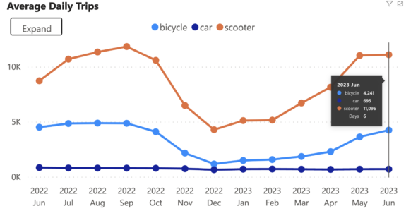
    Chart showing average daily trips by month from June 2022 through May 2023. Scooters are a bit more than twice as high as bikes, which both follow a clear seasonal trend with a dip during the winter. Cars are at the bottom, but stable.

    People in Seattle took 3.7 million trips on shared bikes and scooters in the past year, a massive rebound from the 1.4 million trips per year when pandemic restrictions and many business closures were in place. During the busiest summer months, the daily rides averaged over 15,000 trips per day.

    Six years into the city’s sometimes turbulent experiment with free-floating shared bikes (and eventually scooters), the devices continue to move a remarkable number of people despite significant price increases. And while scooter trips still outpace bike trips, the rides per device are now similar, according to SDOT data.

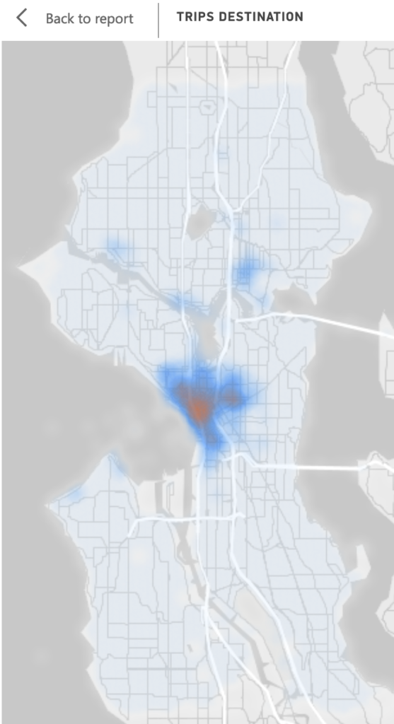
    Most trips are destined for downtown and in nearby neighborhoods like Capitol Hill, First Hill, South Lake Union, Uptown/Lower Queen Anne and the International District. There are also significant hot spots in the U District, Ballard and Fremont—neighborhoods connected by the Burke-Gilman Trail—as well as popular spots along the Alki Trail.

    Heat map showing trips centered around downtown with smaller hot spots in the U District, Ballard and along the Burke-Gilman Trail.
    (more…)
    — Advertisement —
  • The 2023 Fremont Solstice Parade will mark 30 years of naked people crashing the parade on bikes + How to join

    The Fremont Solstice Parade is perhaps Seattle’s happiest day of the year, and that’s in no small part thanks to the explosion of brave creativity that is the pre-parade bike ride featuring hundreds of people using their bodies as art canvases.

    The solstice bike ride is still an unofficial part of the Solstice Parade, but it’s an annual tradition that goes back 30 years to when the first two naked bike riders crashed the 1993 Fremont Solstice Parade. It’s a momentary almost magical space when social norms and people’s personal limits are suspended. People’s feelings of vulnerability transform into self-expression, and they form an art space unlike any other in the city when they group up and ride together.

    There is no official painting party location, a tradition that ran for years up until the pandemic. Instead, people will be getting painted at various private parties around the area, will paint at home before riding to the start or may just paint up at Gas Works Park, where the riders are gathering. Here’s the tentative schedule of events from the Solstice Cyclists website:

    Morning: Paint up, then ride to Gas Works Park.

    1:00 -1:25 Form up at Gas Works

    1:25-1:45 Ride from Gas Works Park to parade route

    1:45-2:30? Loop on parade route as desired, then exit to Gas Works or beyond.

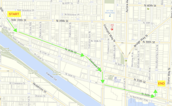
    The official Fremont Solstice Parade starts at 2, and it is also a wonderful display of creativity. No motors or visible sponsorships are allowed. You get things like dance troupes, music acts, big hand-powered floats and large puppets. Below is a map of the parade route from the Fremont Arts Council. Note that the route does not make it to Stone Way N this year, likely due to the major construction project there.

    Map of the parade route starting at Leary Way and NW 39th Street, then heading down N 36th Street to Fremont Place, Fremont Ave and N 34th Street before ending at Woodland Park Avenue N.

    Some tips for first-time riders

    (more…)
    — Advertisement —
  • Bike News Roundup: A cartoon teaching drivers how to pass someone on a bike

    It’s time for the Bike News Roundup! First up, Oregon created a 30-second animation to teach people driving how to safety pass someone on a bike. The “fall distance” bit is an interesting way to teach safe passing on a simplified, public information level. It’s probably better than saying “at least three feet” since people don’t have a yard stick they can whip out to help them visualize that distance while driving.

    https://www.youtube.com/watch?v=mymp1kdcf3I

    Pacific Northwest News

    (more…)
    — Advertisement —
  • Workgroup recommends slowing speed camera expansion until equity issues are resolved

    Circular logo with text "Our Streets" and an illustration of a crosswalk.

    Speed cameras can reduce speeding and collisions while simultaneously bringing in funds to make permanent physical safety improvements to streets. And they can do all this without involving an armed police officer, sidestepping the issue of biased policing. Or at least, that’s how it is supposed to work.

    Whose Streets? Our Streets! is “a BIPOC-focused workgroup” that Seattle Neighborhood Greenways convened in 2020 to “use a pro-equity, anti-racist framework to review laws and practices related to transportation in Seattle,” according to the group’s press release (see full text below or in this PDF). They are “asking the City of Seattle to put the brakes on expanding its automated speed camera program until critical equity issues are resolved.”

    The problem is that biased policing isn’t the only source of injustice baked into our city. Communities of color are also more likely to live near streets with high rates of speeding dues to a long list of historical injustices such as redlining, segregation and so-called “urban renewal” projects like freeways and their related high-traffic collector roads. At the same time, our city and state departments of transportation have historically neglected to make street safety improvements in communities of color.

    The result is that communities of color are more likely to have streets designed to encourage speeding, such as streets with too many lanes that are too wide. These are the kinds of streets most likely to give out automated speeding tickets, which means that a disproportionate share of speed camera tickets end up going to people of color. It’s a classic example of trying to create a “color-blind” system that actually just reinforces existing inequities. Instead, it will take intention to craft a speed camera policy that is both effective and fair.

    Whole Streets? Our Streets! has produced a report documenting the problem and suggesting ideas (PDF). More details from their press release:

    (more…)
    — Advertisement —
  • Port finished trail work in less than one day

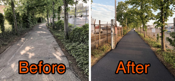
    Images courtesy of the Port of Seattle

    The Port of Seattle’s Interbay detour ended up lasting less than one day rather than the originally-announced 5-day closure. And the result is a much smoother trail surface. Tree roots poking up from below had made the stretch of the Elliott Bay Trail through the Interbay rail yard very bumpy and jarring.

    As we reported in our previous post, the trail detour exposed Interbay’s serious lack of safe walking and biking options. The Port responded to concerns about the detour by making the closure as short as possible, which was great. But Seattle needs to take a serious look at Interbay’s dangerous and uncomfortable streets as the area becomes more and more of a destination rather than only an industrial area with a highway-style road through it. Sound Transit’s light rail line to Ballard will serve Interbay, and the streets need to be friendly for people outside of cars before that happens. And it is going to take a lot of work to get there.

    (more…)
    — Advertisement —
— Advertisement —

Join the Seattle Bike Blog Supporters

As a supporter, you help power independent bike news in the Seattle area. Please consider supporting the site financially starting at $5 per month:

Latest stories

— Advertisements —

Latest on Mastodon

Loading Mastodon feed…