The magazine is a touch-screen-optimized recap of some of our recent posts on this blog. So if you read everything on the blog, don’t expect to find any new content. But for those of you who like to kick back and get caught up, enjoy!
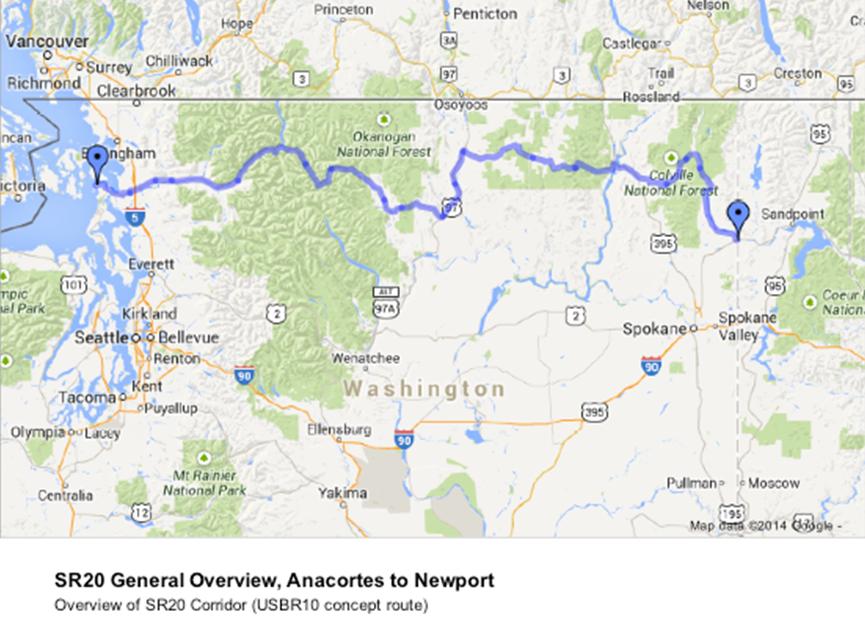
Earlier this month, Washington submitted an application for official recognition of US Bicycle Route 10, the state’s first addition to the in-development nation-wide network of bicycle routes. If approved, it would also be among the first such routes on the west coast.
Filed jointly by WSDOT and Washington Bikes, the application for USBR 10 would gain Federal designation as a cross-country bike route and provide a strong foundation for investments in bike travel and tourism efforts across the state.
Drawing a line on a map is easy. But designating an official US Bicycle Route is a huge amount of work, and has been a labor of love by Washington Bikes leaders from around the state like John Pope, Barb Culp and Lynn O’Connor. In fact, the work to create the route could prove to be a big part of the value of the process since it involves engaging nearly every community along the way.
The application will go before the May 28 meeting of the American Association of State and Highway Transportation Officials (AASHTO) Special Committee on US Route Numbering. Here’s how Pope described the process in a spring 2013 blog post:
The USBRS process involves working with jurisdictions and cyclists along a conceptual route corridor, selecting destination towns and finding the most bike-friendly combination of roads. Once the nominated route is complete, it is reviewed once again by the jurisdictions (towns, counties and WSDOT regions). The draft nomination then needs approval from the top transportation directors of the affected adjacent state, our state and finally the AASHTO USBRS numbering committee. (more…)
Strava is an online service that allows people with a smart phone or GPS device to track their bike rides and share the data with others. It’s very popular in distance and racing circles and has a (sometimes problematic) competitive element to it, but like any tool people can use it to track whatever kind of bike ride they want to.
The company has put together a heat map showing the most common bike routes used by Strava users, and the result is pretty much a map of historic and long-loved regional bike routes.
Obviously, this map only represents a small percentage of people who bike, and only a percentage of their bike trips. People are more likely to track longer rides, which explains why this map is a pretty accurate compilation of popular recreational rides and longer commute routes.
For example, the Mercer Island Loop is one of the most popular routes on the map even though the transportation utility of the loop is very limited unless you live on the island.
But it’s a cool insight and verification of regional bike routes. You can also play around with the map to look at running routes. Check it out.
Notice anything interesting in the Strava data? Any surprises? Share your thoughts below.
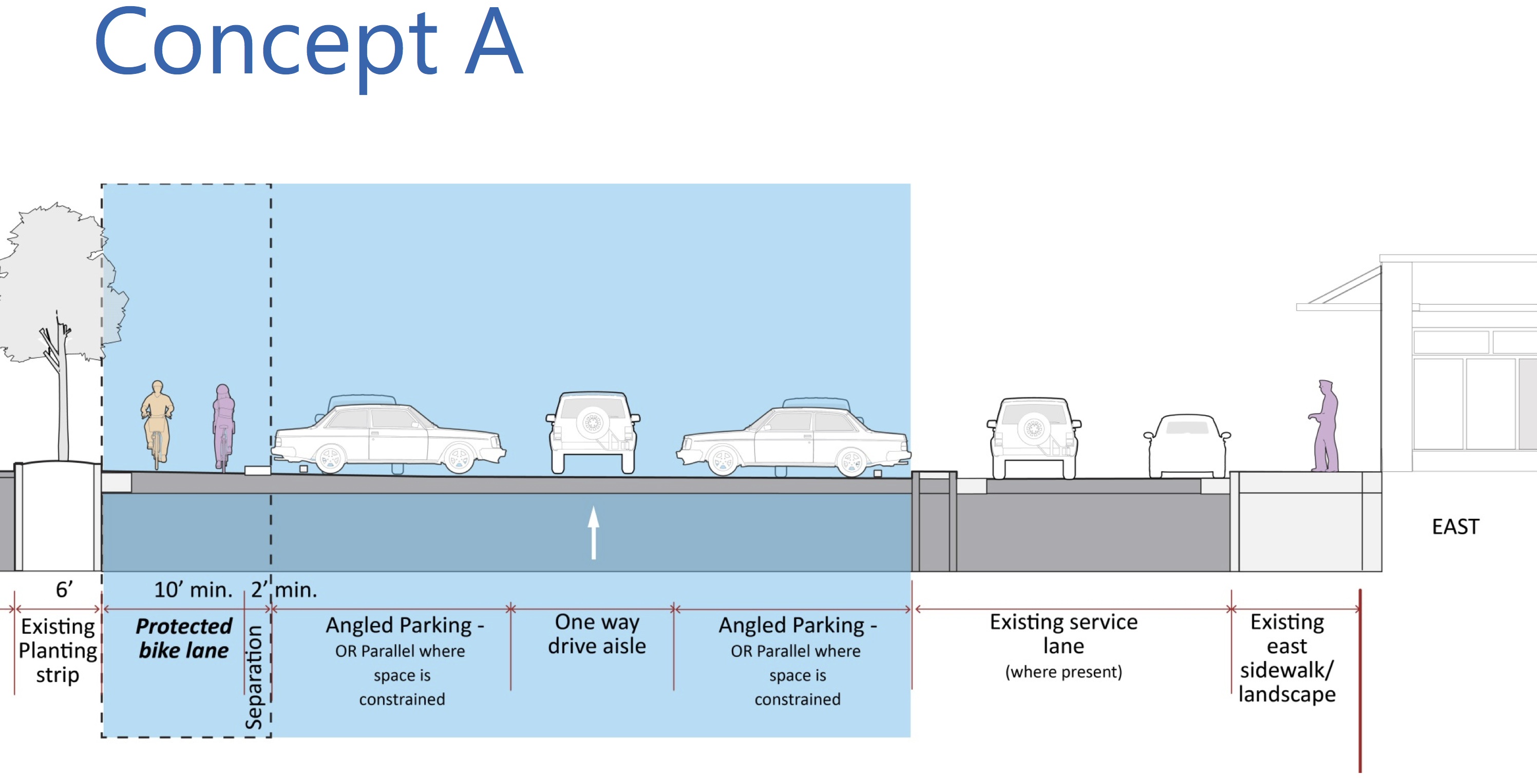
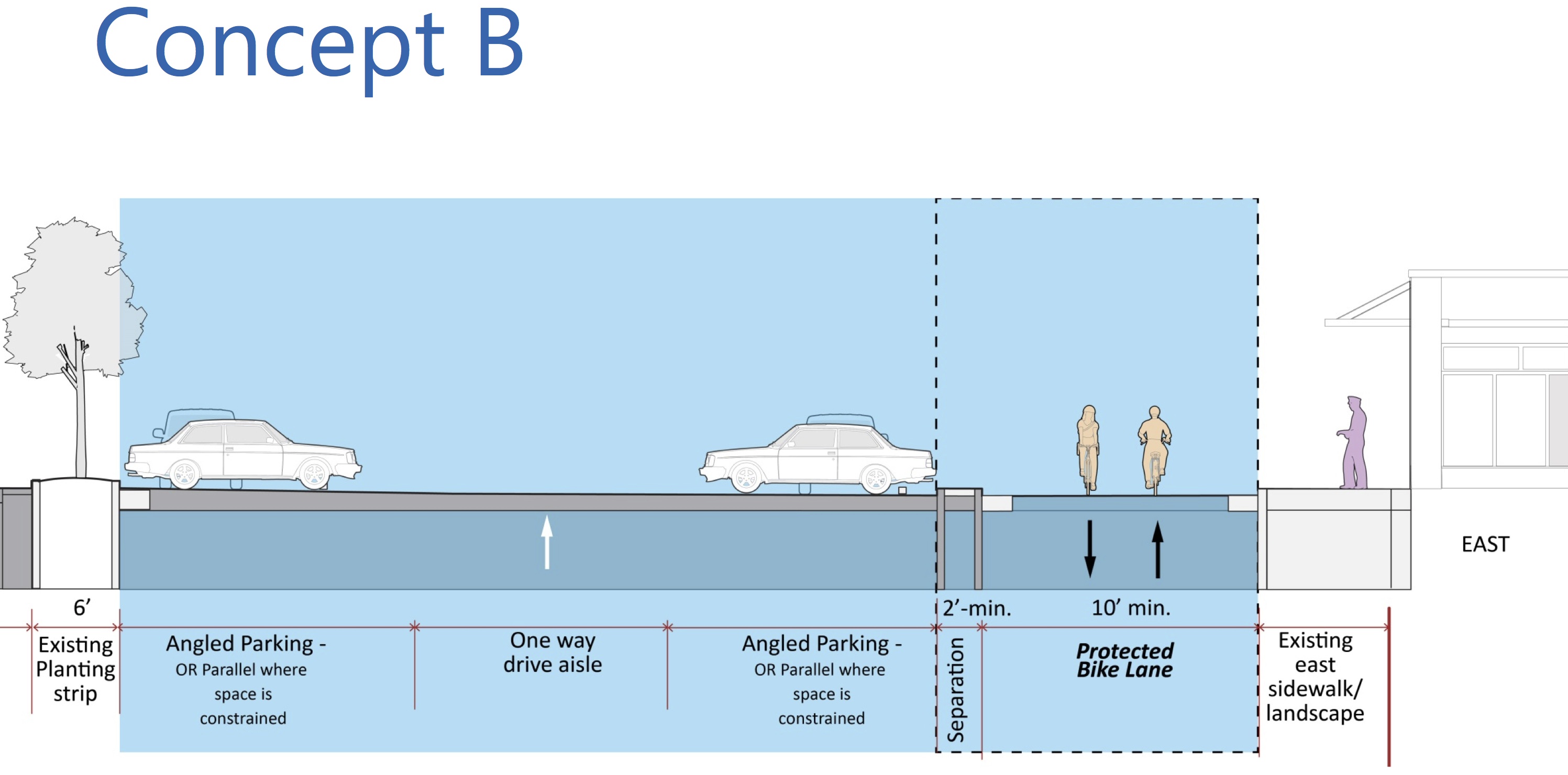
After conducting exhaustive parking studies and some preliminary feasibility work, planners have come up with two rough concepts for the Westlake bikeway.
The plans are general concepts that planners brought before the Westlake Design Advisory Committee earlier this week to gather feedback and give those involved in the design process information to take back to their communities.
There will also be a public open house to discuss the options the evening of May 21 (location TBD).
In essence, one option would stick mostly to the Lake Union side of the city-owned parking area and the other option would stick mostly to the Westlake Avenue side of the parking area. A third option on the west side of Westlake Avenue was taken out of the running because early study suggested it would be far outside the project “scope and budget,” planners said.
Both options would increase safety and meet the project’s primary goals, as stated by a presentation to the advisory committee:
Safety: Provide a facility comfortable for bicyclists of all ages and abilities
Safety: Provides separation from motor vehicles and pedestrians
Safety: Provides predictability within parking lot
Connectivity: Provides connection to existing biking and walking facilities
Accessibility: Flat, low-stress facility
Beyond the primary goals, there are other project concerns to consider. Here’s how the two options compare on a short list of other concerns: (more…)
The Seattle Bike Blog events calendar is overflowing, and it’s not even Bike Month yet. Here is a look at some of the bikey stuff happening this weekend:
Silly Hilly
As we reported, the city is planning a neighborhood greenway through the Central District and parts of Capitol Hill and Montlake. But there’s one problem: There’s no clear way to get from Capitol Hill to Montlake without going up a very steep hill or traveling on the busy and dangerous 24th Ave.
Well, Seattle Neighborhood Greenways and Cascade Bicycle Club are partnering to host a community route exploration event Saturday to test out ideas in search of a route that will work for people of all ages and abilities.
The Silly Hilly starts at Montlake Elementary at 2 p.m. and ends at Miller Park.
I was a very bad bike news cowboy this past month. I’ve been letting bike news acquire for far too long without rounding it up for you all. So that means today’s post is cosmic in scale. Refill your coffee mug.