— Advertisement —
  • City nearly finished with Olympic Hills Greenway plans, open house Thursday

    Olympic-Hills-Web-Map
    Map of planned improvements (those blurry red things are STOP signs for cross streets). Image from SDOT.

    The city is nearly finished designing the Olympic Hills Neighborhood Greenway, and the community is invited to an open house Thursday to discuss the plans.

    The meetings runs from 6 – 7:30 p.m. at the Lake City Library.

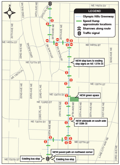
    Planned to open in late 2014, the Olympic Hills Greenway will be the northernmost neighborhood greenway in the city. Perhaps more notably it will also be the city’s first neighborhood greenway where the majority of blocks do not have sidewalks.

    Many neighborhoods in the north and south ends of the city were built without sidewalks, a huge oversight during a crazy era when the walking environment was not considered a priority. When Seattle annexed these areas, the city inherited many miles of sidewalk-free streets, and the cost to add them after the fact is high.

    There is a hope that neighborhood greenways can be one way of making these residential streets safer in the short term while the city slowly builds out the sidewalks. At current funding levels, the city will not finish the sidewalks within any of our lives. Even if the city dramatically increased its sidewalk budget, it will take decades to build all the missing sidewalks. So finding less expensive ways to improve safety in the immediate term is vital.

    Details from SDOT:

    Seattleites continue to demand safer, calmer residential streets. Streets where families and neighbors walk, ride a bike and drive at low speeds on their way home, to stores, to schools and to parks. Seattle calls these streets neighborhood greenways and our goal is to create a network of 250 miles of them.

    This Thursday, March 13 at the Lake City Library, SDOT is meeting with the community to talk about the most promising neighborhood greenway route for the Olympic Hills neighborhood. The recommendation is based on public outreach and technical analysis. Last summer, we hosted a public meeting, met with the City of Shoreline and Lake City Greenways, offered briefings to other neighborhood groups, made site visits and collected traffic data.  The improvements shown on the map below reflect this work. (more…)

    — Advertisement —
  • CHS: Person struck trying to access Broadway Bikeway in construction zone

    Approximate location of collision
    Approximate location of collision

    When the northernmost block of the Broadway Bikeway was closed suddenly in January to accommodate Capitol Hill Station construction, many people voiced concerns that the changes were dangerous and confusing for people on bikes.

    Sound Transit responded by adding more detour signs to make it clear that the bikeway is closed, and that their preferred detour is for people biking to take 12th Ave.

    Unfortunately, the changes may not have gone far enough. Not everyone is headed somewhere with easy access to 12th Ave, and fewer still will be willing to bike six blocks out of the way.

    A woman heading south on Broadway was struck by a turning car at Howell Monday while trying to make it to the temporary start of the two-way bikeway. Luckily, she was not seriously injured, though her wrist was hurt and she had other bumps and bruises. Here’s what she told Capitol Hill Seattle:

    SB cyclists on broadway have two ways to get over to the cycle track, and there has been no signage or direction to indicate what they should do since this block was re-striped (also with no signage or warning). You can ride up to the light and stop as if making a left turn to Howell, though there is no turn lane so cars coming around the construction sb have to squeeze by on your right.

    I typically do this when broadway is busy. Other times I usually take the lane past Denny, signal left, and enter the single lane of the previous cycle track, thinking the sooner I’m in the lane the safer. Today I had done the latter. A nb car approached with its right turn signal on. I looked at the car, as I usually try to make eye contact when crossing a car’s path, but couldn’t see in the car. It seemed to be slowing down, so I mistakenly assumed they had seen me and continued through the intersection, where they hit me. (more…)

    — Advertisement —
  • Sound Transit wants feedback on Northgate Station bike plans

    10001-N160-Northgate-LRRP 60pct-050613.inddWhile the biking and walking discussions surrounding the planned Northgate Station have focused heavily on building a bike/walk bridge over I-5, there are other station design elements that affect bikeability, too.

    Will it be comfortable and easy to bring your bike from the street level to the station platform? Will there be enough bike parking both for long-term and short-term users?

    The station design is at the 90 percent completion point, so now is the time to make sure Sound Transit has got things right and suggest small changes to make it even better for people on bikes.

    They are holding an open house 6–8 p.m. Wednesday at Olympic View Elementary School. Details:

    Please join Sound Transit at the Northgate Station 90 percent design open house. We want to hear from bicyclists!

    Be sure to stop by the Bicycle Table and hear the latest on bicycle parking at the station and access to and from the station from Sound Transit and City of Seattle staff.

    Northgate Station 90 percent design open house

    March 12, 2014
    6:00 pm – 8:00 pm
    (presentation begins at 6:30 pm)
    Olympic View Elementary School cafeteria
    504 N.E. 95th St.
    Seattle, WA 98115

    — Advertisement —
  • Seattle one of six new cities selected for the Green Lane Project

    Screen Shot 2014-03-10 at 11.10.09 AMSeattle has been chosen to be part of the second round of Green Lane Project cities, PeopleForBikes announced Monday.

    A project of the national non-profit bike advocacy organization, the Green Lane Project provides financial and technical assistance to cities to help speed up the installation and adaptation of protected bike lanes on city streets. Cities included in the first round — including Chicago, Washington DC, and San Francisco — have made huge strides in the past two years, and now it is Seattle’s chance.

    UPDATE: Mayor Ed Murray made the following statement Monday morning:

    The City of Seattle is proud to have been selected by PeopleForBikes to participate in their Green Lane Project, which has helped cities across the nation develop and implement protected bicycle lanes … These lanes are an important part of Seattle’s transportation infrastructure and at the heart of our Bicycle Master Plan. The Green Lane Project will help us make progress on our goals of making Seattle more interconnected, safe and environmentally sustainable.

    We will have more soon on what this means for Seattle (I’m currently on vacation in Denver, but will return Tuesday). In the meantime, here are details from PeopleForBikes:

    The PeopleForBikes Green Lane Project has selected six new U.S. cities to become the second class in an intensive two-year program to build protected bike lanes. Atlanta, GA, Boston, MA, Denver, CO, Indianapolis, IN, Pittsburgh, PA and Seattle, WA will receive financial, strategic and technical assistance to create low-stress streets and increase vitality in urban centers through the installation of protected bike lanes. The six cities were chosen from more than 100 U.S. cities that submitted letters of interest for the program. (more…)

    — Advertisement —
  • City releases 2014 bike map, plans major remake in 2015

    2014 2 18 Frontside v4-cropThe city has released the official 2014 bike map, and it comes with an updated color scheme to help highlight routes with the most protection from moving traffic.

    You download a PDF version of the print map at the bottom of this post. If you want to score a print copy, you can order one online for free. Just give your address and Washington Bikes will mail one to your house. How cool is that?

    The city also has an interactive online bike map that shows bike routes according to your cycling confidence level. For mobile users, there’s also a really nice mobile version.

    While the print map looks nice, some key issues still persist. The biggest issue, in my opinion, is that it is somewhat difficult to predict the stress level of each route based solely on the lines.

    For example, some busy streets without bike lanes are marked in a skinny blue line because they are marked with sharrows. Others are marked with thick yellow lines to signify busy streets without bike lanes that are commonly used as bike routes. From the perspective of someone on a bike unfamiliar with the area, these experiences are essentially the same, since sharrows do very little to improve the biking experience.

    However, the city is aware of these issues and announced at a recent meeting of the Seattle Bicycle Advisory Board that they are planning a big remake of the map for 2015. Next year’s map may make an effort to mark bike routes according to stress level. That way, instead of just telling people what kind of bicycle facility exists, the map will tell people what the biking experience will feel like. (more…)

    — Advertisement —
  • Westlake Bikeway Update: Design committee members will be announced soon, construction to start in 2015

    Westlake Exist-no scaleAmid all the squabbling over the Bike Master Plan lawsuit, it may have been easy to forget that, wow, the city is actually going to build a modern bikeway on Westlake. The goal is to start construction in 2015.

    Mayor Ed Murray is nearly finished selecting the members of the Design Advisory Committee, which was created as part of a settlement so the Westlake Stakeholders Group would drop the Bike Plan lawsuit. The 13 members should be announced soon, according to a Wednesday presentation to the Bicycle Advisory Board.

    The committee will meet regularly throughout most of 2014, when the design team is doing the heavy lifting for developing the plans. The committee may evolve into a another role later as is needed or helpful.

    The committee is advisory, and SDOT will retain final design decision ability. Here’s the committee’s planned makeup, according to the project website: (more…)

    — Advertisement —
— Advertisement —

Join the Seattle Bike Blog Supporters

As a supporter, you help power independent bike news in the Seattle area. Please consider supporting the site financially starting at $5 per month:

Latest stories

— Advertisements —

Latest on Mastodon

Loading Mastodon feed…