— Advertisement —
  • Latest Alaskan Way design includes continuous waterfront bike lane with plan for cruise detours

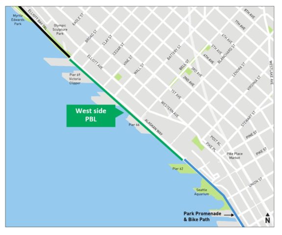
    Map showing a west-side protected bike lane.
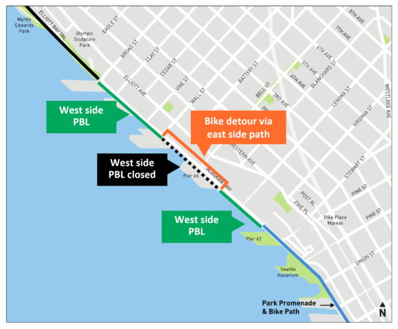
    map showing the bike detour between Blanchard and Wall Streets.
    Images from SDOT.

    The city plans to build a continuous bike lane on the waterfront side of Alaskan Way under the latest design, SDOT announced Monday. Rather than permanently detour the bike route across Alaskan Way twice within a couple blocks, the new design includes a detour plan for use only during busy cruise ship loading times in the area around Pier 66. This compromise solution came together after significant discussions between the Port of Seattle, Cascade Bicycle Club and the city. A recent push by Seattle Neighborhood Greenways also got more members of the public involved, sending letters of bike lane support directly to Port Commissioners.

    Cascade celebrated the news, writing in an email to supporters that “more than 700 of you joined us to ask planners to ‘go back to the drawing board.’ They did just that.”

    “The new design creates a continuous, protected bike lane that will be open the majority of the year,” Cascade continued. “There will be a short detour only during cruise hours so that we can bike around the chaotic crowds (and their luggage). When it’s complete, families, visitors, commuters, and others can ride safely and comfortably along the waterfront without zig-zagging across the street and back for most of the year.” Cascade is encouraging people to use their handy online form to send a thank you note to the city’s transportation officials and leaders that also encourages sturdy bollards to protect the bike lane and intuitive signage and signalling when the detour is in place.

    During cruise operations, the detour would cross at Blanchard and Wall Streets, which already have traffic signals. The path would then follow a path that is partially built already, though it appears the city will need to remove more of the old George Benson Streetcar tracks to create space for the path. Below are diagrams of the two intersections from SDOT:

    (more…)
    — Advertisement —
  • Seattle scores 62/100 in bike-friendly ranking, good enough for 3rd place among big U.S. cities

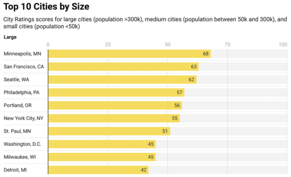
    Bar chart showing the scores of the top 10 large U.S. cities. Minneapolis is first, San Francisco is second, and Seattle is third. Portland is down in fifth.
    From People For Bikes.

    Bike-friendly city rankings are a bit silly, but there’s usually some interesting things we can learn from them. There are so many variables that make places different and might impact a person’s experience riding a bike in them that distilling an entire city’s bikeability down to a number is impossible. For example, I’m guessing someone who lives along Rainier Avenue, which has no bike lanes and no comparable alternative bike routes, might scoff at the idea that Seattle is the third best large U.S. city for biking. But that’s where People For Bikes placed our city in its 2023 Best Places to Bike list.

    But before Seattle goes and gets a big head about its spot on the bike-friendly podium, the city only scored a 62 out of 100. Only cities with 80 points or more are considered places where “most common destinations are accessible by safe, comfortable bike routes,” according to People For Bikes. So there’s still a lot of work left to do. Unfortunately, the competition to be the most bike-friendly city in the U.S. just is not very fierce. There are many places where people talk about being bike-friendly, but not enough places are actually out investing in making the necessary changes.

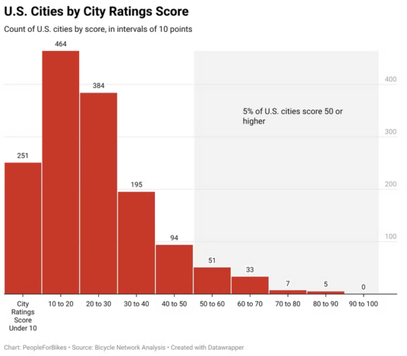
    Bar chart showing the distribution of ratings among U.S. cities. The tallest bar is for scores between 10 and 20 with a bell curve distribution around it. One 5% of cities scored higher than 50.
    Seattle scored a 62, which is unfortunately elite among U.S. cities. This chart includes cities of all sizes.
    (more…)
    — Advertisement —
  • SDOT begins study of CM Strauss’s Leary Way concept for the Missing Link + Legal update on Shilshole

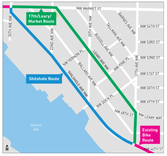
    Map comparing the Shilshole route to the 17th/Leary/Market route.

    At the urging of Councilmember Dan Strauss and with Mayor Bruce Harrell’s support, SDOT is beginning early design work on a potential alternative for the Burke-Gilman Trail Missing Link in Ballard. Though the city has a design fully completed and ready for construction along Shilshole Ave NW, the construction permits are held up in court as opponents continue their decades-long campaign to stop the project. The latest delays spurred CM Strauss to ask SDOT to study an alternative he hopes can avoid further lawsuits and get a walking and biking connection built.

    SDOT has not abandoned the Shilshole plan, but they are developing a Leary plan in addition to it. They hope to have the design up to the 30% mark by the end of 2023. They even have a very simple online feedback form you can complete that includes one open-ended prompt: “Tell us your feedback.”

    Trail advocates are sort of in a position of limbo. The Shilshole plan is fully designed and was the preference of the vast majority of people during the drawn-out design and environmental review process. But Leary Way and Market both need big safety upgrades, and a protected bike route along there would be genuinely awesome. But it also feels like a different project than the trail. Then again, there’s funding to make improvements now, and we don’t know how long these court battles will last. But also, how do we know this project won’t also get sued into oblivion? If we’re basing that assumption on the word of the appellants, well, we’ve fallen for that trick before. So keeping both options open seems like a good strategy. ¿Por qué no los dos?

    “We’re open to the Leary/Market study as long as it doesn’t add any delay to Shilshole,” Cascade Bicycle Club Executive Director Lee Lambert told Seattle Bike Blog.

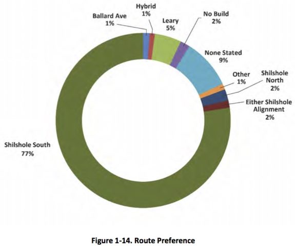
    Pie chart showing 77% support for the Shilshole South route for the trail and 5% for Leary.
    From the Draft Environmental Impact Statement (AKA the Missing Link Mega Study).

    Latest legal challenge

    (more…)
    — Advertisement —
  • Man who killed Michael Colmant sentenced to 20 months in prison for vehicular homicide and hit-and-run

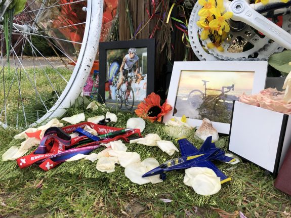
    A small airplane and Boeing Field mementos sit on the ground near the ghost bike.
    2021 photo of the memorial for Colmant near the site of the fatal collision.

    Julian Hamilton, 25, pleaded guilty to hitting and killing Michael Colmant in April 2021 and was sentenced to 20 months in prison.

    Hamilton was driving under the influence after drinking in the park when he crossed to the wrong side of Seward Park Ave S just east of the intersection with Wilson Ave S and collided head-on with Colmant, who was biking downhill toward the park. Hamilton then fled the scene and tried to hide the damaged vehicle in Tacoma. He did not turn himself in. He was arrested a year and a half later thanks to a tip that came in after the King County Council offered a $50,000 reward for information in the case. Colmant was a King County employee who worked at Boeing Field.

    Q13 News has a report that includes Hamilton’s tearful apology in the court room as well as statements from Colmant’s loved ones.

    “I’m sorry for my actions that day and the delay in justice,” he said, reading a prepared statement. “I’m sorry I didn’t come forward sooner. I was afraid of the consequences. But I know this is the right thing to do.”

    “There is no sentence that will give him the justice he deserves, and no sentence handed down will bring him back,” said a statement from Colmant’s step-daughter read in court.

    (more…)
    — Advertisement —
  • Federal grants will fund Seattle ‘low-emission neighborhoods,’ Sound-to-Pacific Trail planning, Shoreline light rail connections + more

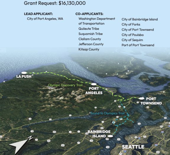
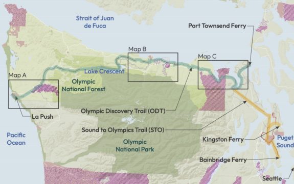
    Newly-announced Federal RAISE (“Rebuilding American Infrastructure with Sustainability and Equity”) grants will help fund several interesting walking and biking projects around the region, including planning work for an ambitious trail from the Bainbridge Island Ferry Terminal to La Push on the Pacific Coast.

    Aerial view of the project area showing the Sound to Olympics Trail and Olympic Discovery Trail with spur to Kingston and Port Townsend. Text says Grant Request $16,130,000 with Lead Applicant City of Port Angeles.
    Maps from the Puget Sound to Pacific grant application.

    The City of Port Angeles led a successful grant application for the full trail planning project, receiving their full $16,130,000 request. This means they should have the resources now to bring the entire 200-mile trail project to 100% design, making it ready for construction. The trail will span many different municipalities, tribal lands and counties in addition to Olympic National Park, but it already has major head starts working in its favor. It combines the Olympic Discovery Trail, an iconic but unfinished rails-to-trails project, with the relatively nascent Sound to Olympics Trail while also adding spurs and a loop to reach Poulsbo, Kingston and Port Townsend.

    But beyond the local benefits of this trail, it will also serve as the Pacific Ocean terminus for the transcontinental Great American Rail-Trail.

    (more…)
    — Advertisement —
  • WA pedestrian deaths were down in 2022, but still far above pre-pandemic levels – UPDATED

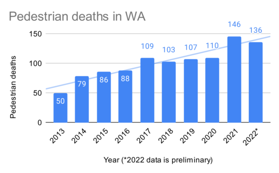
    Bar chart of pedestrian deaths in Washington State 2013 through 2022. 2013 is the low at 50, climbing to 109 in 2017, then staying consistent until jumping to 146 in 2021 then back to 136 in 2022.
    UPDATE: I updated this chart with data from the Washington Traffic Safety Commission, which has more historic data and more updated counts.

    The good news is that the horrific increase in pedestrian deaths Washington State saw in 2021 did not continue to increase in 2022. But that’s the end of the good news in this story. Preliminary counts in a recent report from the Governors Highway Safety Association show that an estimated 130 pedestrians were killed in Washington State in 2022, a decrease compared to the state’s shocking total of 144 deaths in 2021. However, the 2022 count is still far above the 101 deaths in 2019, and the national trend showed the count continuing in climb in 2022 over 2021.

    UPDATE 6/27: In response to a reader’s question, I have updated the chart above with additional data from the Washington Traffic Safety Commission, which also has more updated counts compared to the GHSA report. Unfortunately, the WTSC has counted 136 pedestrian deaths in 2022, down from 146 in 2021 but still horrifically far above the 50 deaths in 2013.

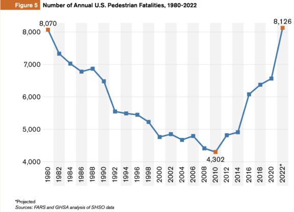
    Nationally, pedestrian deaths rose 77% between 2010 and 2021 while all other traffic deaths rose 25%, and the U.S. likely crossed a grim total not seen since 1980: More than 8,000 pedestrians killed in a single year.

    Line chart showing U.S. pedestrian deaths biannually since 1980. The only two points above 8,000 are 1980 and 2022. The low point was 4,302 in 2010.

    The chart should be setting off top level emergency alarms in every transportation department and regulatory office in our nation. Something has changed dramatically since 2010, and no it isn’t iPhones. Most of the world is seeing fewer traffic deaths, and they bought iPhones, too. Dangerous vehicle designs, especially among popular SUVs and pickups, are likely among the biggest factors behind this increase. Vehicle size and weight has increased dramatically, and those increases have come at the expense of people outside of them. “Light trucks,” an official vehicle category that includes everything form minivans to pickups to SUVs including so-called “crossover” SUVs, now make up more than 75% of all cars sold in the U.S. according to Transportation Alternatives in New York City. The average weight of a passenger vehicle has increased from 3,200 pounds in 1980 to 4,200 pounds today. “Supersized vehicles,” as Transportation Alternatives calls them, are 41% more likely to kill a pedestrian that they strike compared to a sedan traveling at the same speed. But this effect is multiplied by the fact that supersized vehicles are less maneuverable and have worse driver visibility than most sedans, making their drivers 3–4 times more likely to hit a pedestrian while turning compared to sedan drivers.

    “Between 2014 and 2019, 43% of children killed on New York City streets were struck by SUVs or larger vehicles,” Transportation Alternatives wrote. “Between 2019 and today, that number rose to 77% of children killed. In 2022, a record number of children were killed by traffic violence in New York City, and more than 80% were struck by SUVs or larger vehicles.”

    (more…)
    — Advertisement —

2024 Voter Guide


— Advertisement —

Join the Seattle Bike Blog Supporters

As a supporter, you help power independent bike news in the Seattle area. Please consider supporting the site financially starting at $5 per month:

Latest stories

— Advertisements —

Latest on Mastodon

Loading Mastodon feed…