— Advertisement —
  • CM Strauss asks mayor to study Market and Leary for Missing Link

    Map of Councilmember Strauss's proposed route on 17th, Leary and Market.Councilmember Dan Strauss sent a letter (PDF) to Mayor Bruce Harrell asking him to shift SDOT’s Missing Link efforts to focus on designing and building a Burke-Gilman Trail connection on Market Street and Leary Way in Ballard.

    “I see a lot of positive attributes to bringing this trail into our businesses and multi-use core,” said Strauss in an interview. “The trail on Shilshole requires people to cross Shilshole.”

    His letter comes as new legal losses have put the city’s plans for a Shilshole Avenue trail back on ice. The state’s Shorelines Hearings Board issued a “courtesy” letter (PDF) to the city and Cascade Bicycle Club letting them know that they sided with the Ballard business coalition suing to stop the trail. The letter did not specify reasons or the options for appeal, but it’s bad news for the city’s plan to build a scaled-back version of the trail connection. With the Move Seattle Levy expiring at the end of 2024, there is a sense of urgency to invest the public’s money in a timely manor rather than continue to hold the funds for an unknown period of time. So even if the Board’s decision could be successfully appealed, it would mean further delay and further court battles. It’s not clear how long the city’s elected leaders would be willing to hold that funding for the trail when there are so many other uses for it.

    This is the biggest development in the Missing Link saga in years. If Strauss’s request gathers enough political momentum and favor from Mayor Harrell’s office, it could mean a brand new design process for a legitimately exciting biking and safe streets project through the commercial core of Ballard. But it may also spell doom for a trail connection on Shilshole, which is the most direct and by far the most preferred route according to feedback collected in the city’s environmental megastudy back in 2017.

    Rough design concept from Strauss showing a 12 foot trail plus a 5-foot buffer and and sidewalk.
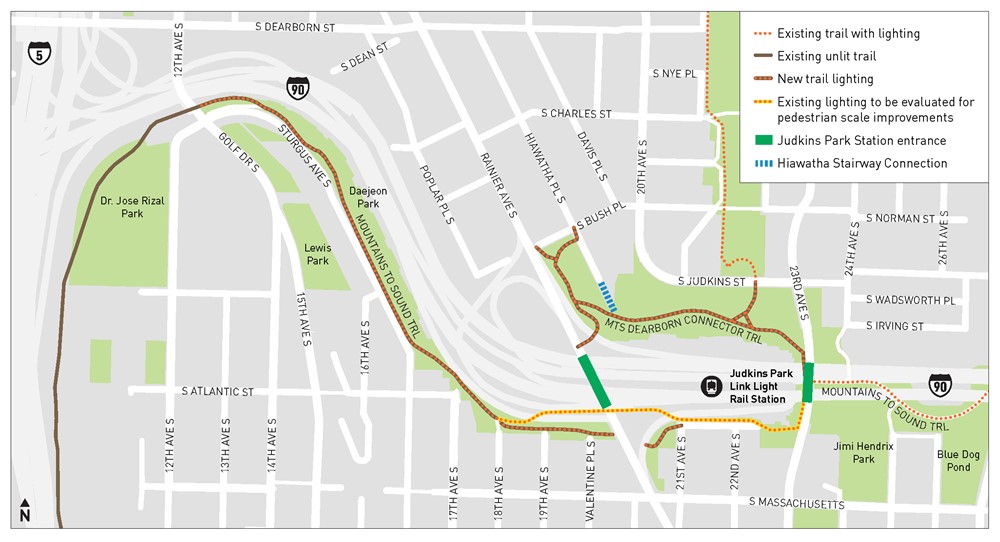
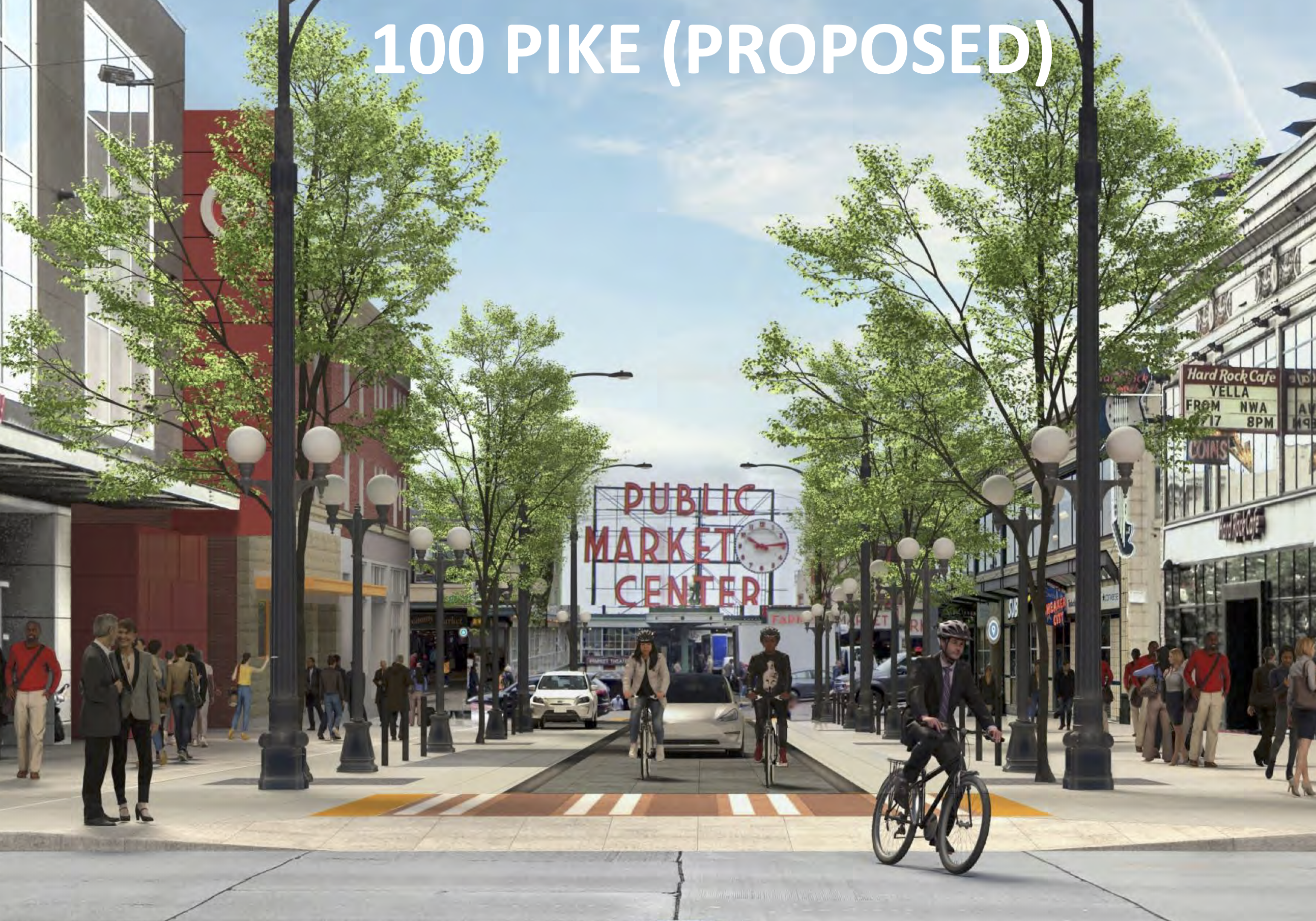
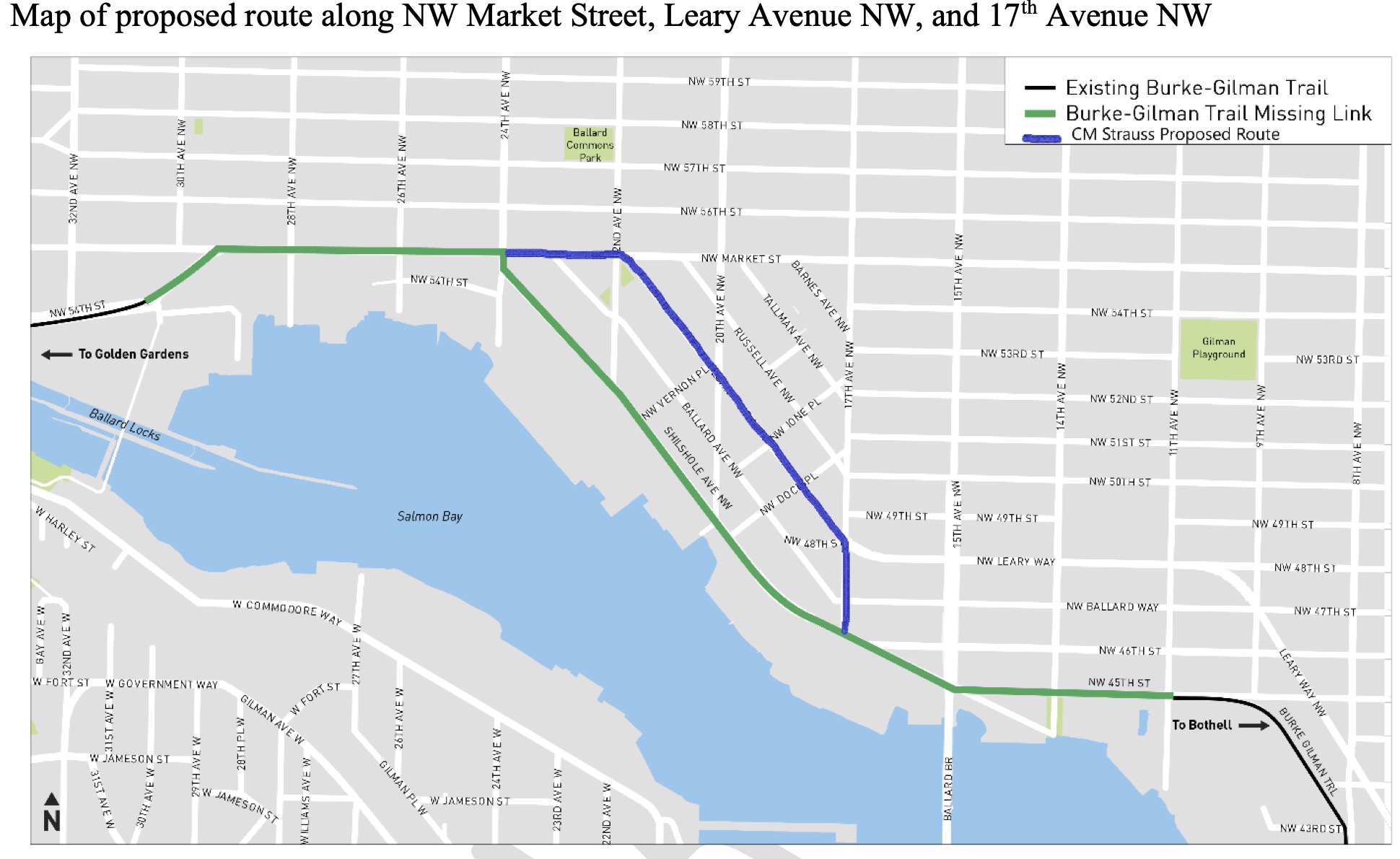
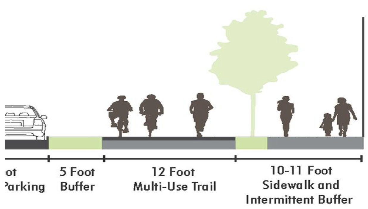
Strauss’s letter essentially calls for an extension of the trail design already on Market Street (though not technically open as a trail yet) between 24th Ave NW and the Locks. That 12-foot walking and biking trail would continue on Market, then turn down Leary and 17th Ave NW to meet back up with the Burke-Gilman Trial.

    The letter itself does not officially change anything. One councilmember does not have such power. But it has a lot going for it in terms of timing and public benefit. Leary absolutely needs a safe streets update because it is a very wide and fast street through what has become a dense neighborhood. Market also needs safety improvements. In a vacuum, there is no question that this project would be great for biking and bike access to these homes and businesses. So with the city’s Shilshole trail plan somehow still not having a legal path forward, the Strauss route presents a chance for a reset. But it would be a bitter pill to swallow for many people who have fought for the Shilshole route for decades.

    Cascade Bicycle Club is currently in a somewhat awkward spot. Because the Shorelines Hearings Board has yet to make their final decision, it’s not yet clear what sort of appeal options there are in that case and what the chances are of winning. It doesn’t make sense to abandon that effort unless it’s a clear loser, especially when that final decision should be coming soon. But they are generally positive on Dan Strauss’s plan, with some hesitancy.

    “We’re not opposed to this option so long as it doesn’t cause any unnecessary delay to the Missing Link Shilshole route,” said Cascade Executive Director Lee Lambert.

    Even if the Strauss plan does gain favor with the mayor and SDOT, there are still a ton of questions and challenges ahead. Will any business owners sue to stop it as was done on Shilshole? The city has been double-crossed on this project before, so this is a legitimate concern. Because the Leary/Market option was studied and ruled out during the environmental megastudy, does that have an impact on the city being able to build it now? And even if the trail is completed on Leary and Market, Shilshole will still be dangerous to the public and in need to safety improvements.

    Two people shake hands near a podium. A group of people stand behind them.
    Former Councilmember Mike O’Brien, a longtime trail supporter, and Warren Aakervik, the retired owner of Ballard Oil, shook hands during a 2017 press conference announcing a compromise deal.

    Many Seattle politicians have tried to be the one who finally brings people together to solve the Missing Link. Mayor Ed Murray was able to get trail opponents together to shake hands and smile back in 2017, but then the opponents went back on the deal and sued anyway. At this point, I think anything that is genuinely good and has momentum is worth considering. I think it makes sense for city leaders and bike advocates to wait for ongoing legal decisions to be finalized, assess the feasibility of the options, then move forward with something that can actually get done.

    — Advertisement —
  • Trails near Judkins Park Station will get lights

    Map of trail sections to get lighting, including the sections headed toward Dearborn and Judkins Park.
    Map from the SDOT project page.

    Trail connections to the under-construction Judkins Park light rail station will get lighting as the city and Sound Transit work to improve station access conditions before it opens in … uh … well, at some point.

    Judkins Park Station is the only new Seattle station on the East Link line, and it could be one of the most bike-friendly with the Mountains-to-Sound Trail passing directly in front of its 23rd Avenue entrance. Trails already connect to Judkins Park, Dearborn/Hiawatha, through Sam Smith Park bound for the I-90 Bridge, and the northern edge of Beacon Hill. These trails act as collectors for many bike routes in the Central District, Beacon Hill, Atlantic, and the North Rainier areas. It will be fascinating to see what kinds of new bike-and-transit combos will be possible and popular once this station opens.

    These trails already get all-hours use, but the light rail station is sure to increase the number of people using them after dark. The lighting is funded by a $2.1 million Sound Transit station access grant and $520,000 in Move Seattle Levy funds.

    Markings are already on the ground, and construction will take 7–8 months. Be prepared for “limited trail closures” while crews are working.

    — Advertisement —
  • WA Bikes: Driver’s license review bill ‘very likely’ + More legislature updates

    Photo of people biking near the capitol building in Olympia with text WA State Legislative Session Update 3-7-23.We are well into the phase of the legislative session where it becomes really difficult to keep track of which bills are moving, which ones are stalled, which have been amended to be better, which have been amended to be worse, and which are dead. So I highly suggest signing up for legislative updates from organizations like Washington Bikes, who are tracking things closely. You can also get a quick look at that status of biking and safe streets bills by checking out the WA Bikes bill tracker document.

    Here’s the latest update from Washington Bikes:

    We’re more than halfway through Legislative Session and things are moving faster than ever!

    At this point in the legislative process votes can happen at any time, discussion and debate can take minutes or hours, and we’re working hard to get our bills through the process. There have already been some exciting votes, and there’s more to come.

    Highlights for week 9 (March 6 – March 10):

    • On Thursday, March 9, HB 1319 (driver’s license review after a collision involving a person walking or biking) is scheduled for Executive Session with no hearing needed! That means we will *very likely* have a new law soon requiring drivers who hit a person biking or walking to re-test for their license. This is a big win!
    • Last week, a number of key bills passed out of their house of origin, including SB 5452 (authorizing impact fee revenue to fund bike and pedestrian infrastructure improvement), SB 5743 (a technical fix to Move Ahead WA) and SB 5583 (improving young driver safety). These bills are part of Washington Bikes’ safety agenda, and we’re proud to see them move through.

    At this point in the session, only one of our priority bills has died – the #WrongonRed bill to ban right turns at intersections where lots of people walk and bike. Thanks to your advocacy, so many more good bike bills made it through.

    Background information:

    — Advertisement —
  • No, the city is NOT cutting down cherry trees to build a bike project

    Screenshot of a tweet by the Seattle Times that says "To make way for a bike and pedestrian corridor, eight cherry trees will be cut down."Contrary to what you may have read on Twitter or saw written on yellow signs on trees on Pike Street near the market, Seattle’s decision to cut down cherry trees on the block between 1st and 2nd Avenues has nothing to do with bike improvements.

    In fact, the project removing the trees will also remove the existing two-way bike lane on this block, a significant downgrade for biking. The change is part of the larger “Pike Pine Streetscape and Bicycle Improvements Project,” which does include exciting bike lane improvements between 2nd Ave and Bellevue Ave. However, the project’s design for the block with the doomed cherry trees will dramatically expand the amount of space for cars at the expense of all other users. Below are some concept images from the project’s outreach materials:

    Existing Pike Street photo looking from 2nd Ave toward 1st. There are two lane, one for general traffic  and one used for a two-way bike lane. There is no parking. Proposed design for the block with a wide curbless space and no bike lane. Cars have more space, including new parking spaces.Looking at this, and you can see why it was so frustrating to read a Tweet from the Seattle Times that said, “To make way for a bike and pedestrian corridor, eight cherry trees will be cut down.” The exact opposite is true. This block’s design deletes the entire two-way bike lane and slightly reduces the sidewalk width in order to add car parking and widen the driving lane. Just because the concept image creators desaturated the colors in the “existing” photo doesn’t mean the “proposed” image is better. Here’s let’s try it another way:

    The proposed image again, but with low saturation and contrast. Same existing image, but with higher saturation and contrast.For what it’s worth, Seattle Bike Blog would happily see the city cancel this one block of the project and more forward with the rest. This “curbless” street concept has yet to actually prove to be an improvement for walking or biking in Seattle, though they keep trying it (Denny Way near Capitol Hill Station and Bell Street are two such examples). In our deeply-ingrained car culture, cars will occupy every inch they can. The wider the driving lane, the faster people will drive, and if there is space that is not physically blocked, people will park their car there or use it to pass someone else. A curbless street is only better for people walking and biking if there are significant obstacles for cars or if cars are not allowed at all. The proposed design is worse in every way.

    So keep the cherry trees until they actually need to be replaced. As David Kroman’s story in the Times notes (unlike the Tweet, the story gets the details right), cherry trees don’t love being in urban tree pits and might not last much longer. Maybe by then we’ll have a design for this block that truly does make it better for walking and biking.

    — Advertisement —
  • King County study finds helmet use unchanged after law repeal

    Table comparing helmet use observations in 2004 to 2022. The top line is 85% use in 2022 versus 80% use in 2004.One year ago, the King County Board of Health voted 11–2 to repeal the county’s rare all-ages bicycle helmet law. One of the arguments in favor of repeal was that the law was not a top reason that most people choose to wear a helmet. To test this assertion, Public Health – Seattle & King County conducted an observational study (PDF) to assess helmet use after the repeal went into effect. And sure enough, helmet use remains high across King County, especially for people riding their own bicycles.

    Researchers counted about 2,000 people at more than 50 different locations around the county. 91% of riders on personal bicycles wore a helmet while 45% of bike share users wore one. Only 9% of scooter share riders wore a helmet. Together, bike and scooter helmet use sat at 85%, with is higher than the 80% a similar study found in 2004. As David Kroman noted in the Seattle Times, the results are also nearly identical to a 2018 study led by a group of Harborview and UW researchers. This suggests that people are choosing to wear a helmet for reasons separate from the threat of police action, such as feeling safer with head protection.

    It is probably worth revisiting this study in a few years to see if things change with time, but this initial result is a good sign that the Board’s reasoning was indeed sound. It should also be instructive for other places considering a helmet law repeal. The King County Board of Health was clear during deliberations that they supported the use of helmets, but they had concerns about inequitable enforcement. Black people in Seattle were 3.8 times more likely to get a helmet citation than a white person, an analysis by the volunteer-led Helmet Law Working Group found. “Differences in helmet use between populations cannot explain these disparities,” the group noted in their report. These figures do not account for stops that did not result in a citation.

    On somewhat of a side note, the bike share figure is surprisingly high considering riders would have needed to plan ahead and bring a helmet with them. The sample size was 68, which seems significant enough to take seriously. As someone who owns a bike, my bike share use is mostly limited to spontaneous trips when I’m already out and about and unlikely to have a helmet with me. But I guess there are a lot of users who leave home knowing they are going to be using bike share to get around. It also suggests diverging use cases for shared bikes compared to shared scooters. Are scooters more likely to be used spontaneously while the bikes are more likely to be part of a user’s plan? We already know that bike share trips tend to be longer in distance than scooter trips, so perhaps this is another clue. It also suggests that there is value in bike share separate from scooter share, and that the two device types should not be considered interchangeable by government policy writers or by the companies offering them.

    — Advertisement —
  • Greenways and Cascade seek more specifics in plan to get Vision Zero back on track

    Map showing Top 20 Priority Pedestrian Locations per Council District. Each data point is color coded to show the crash type, such as vehicle turning right, turning left or going straight.
    The top 20 priority pedestrian safety locations. What’s the plan to fix them all as soon as possible?

    SDOT is set to present their “top to bottom review” of the Vision Zero program to the City Council Transportation Committee March 7, and safe streets advocates are pushing for more specifics and hard deadlines to “light a fire under our elected leaders to get Vision Zero back on track,” as Cascade Bicycle Club put it.

    In our previous story about the first draft of the Vision Zero review, we noted that a lot of the recommendations were internal-facing things like reorganizing internal processes and the department hierarchy. This is not necessarily a criticism of the review since this was its stated goal, but it’s also hard for the public to understand the impact of these internal changes.

    The review includes lots of important findings and great statements about what needs to happen, such as the recommendation that the department must “Be willing to reduce vehicle travel speeds and convenience to improve safety.” But the review was somewhat lacking in specifics and timelines for making those necessary changes. Cascade and Greenways noticed this, too.

    “[T]he public needs to know that tangible actions are coming next,” Cascade wrote in their sample letter that people can send to Councilmembers. Use their handy online tool to send your own letter. “Otherwise, it’s just another plan that gets put on a shelf.” Specifically, they are calling for Council to place a timeline on SDOT to accomplish tasks from the review, including a revision of the Vision Zero Action Plan, expanding turn on red restrictions, programming leading pedestrian intervals (giving walk signals a head start), and requiring follow-up progress reporting on these changes.

    Seattle Neighborhood Greenways already offered their Vision Zero ideas back in November, which includes a lot more specific interventions the city could take. Much of their suggestions might be more appropriate for the Vision Zero Action Plan, which is why accelerating delivery of that update is important. This departmental review document is not going to get Vision Zero back on track, but it could help SDOT more effectively deliver safety-focused actions that the Mayor and Council task them with. (more…)

    — Advertisement —
— Advertisement —

Join the Seattle Bike Blog Supporters

As a supporter, you help power independent bike news in the Seattle area. Please consider supporting the site financially starting at $5 per month:


Latest stories

Bike Events Calendar

Jul
20
Sat
9:30 pm World Naked Bike Ride: Full Moon… @ Seattle Rep Parking Lot
World Naked Bike Ride: Full Moon… @ Seattle Rep Parking Lot
Jul 20 @ 9:30 pm
World Naked Bike Ride: Full Moon Ride @ Seattle Rep Parking Lot | Seattle | Washington | United States
Celebrate the Buck Moon by adorning your bicycle with blinky & twinkly lights. It’s the height of summer – warm nights and easy riding with friends. Saturday July 20 Parking Lot at Mercer St &[…]
Jul
25
Thu
7:15 pm Point83 @ Westlake Park
Point83 @ Westlake Park
Jul 25 @ 7:15 pm
Point83 @ Westlake Park
Meet up in the center of the park at 7ish. Leave at 730. Every Thursday from now until forever rain or shine. Bikes, beers, illegal firepits, nachos, bottlerockets, timetraveling, lollygagging, mechanicals, good times.ShareMastodonTwitterFacebookRedditEmail
Jul
27
Sat
all-day Bicycle Weekends on Lake Washing…
Bicycle Weekends on Lake Washing…
Jul 27 – Jul 28 all-day
Bicycle Weekends on Lake Washington Blvd
Details from Seattle Parks: On scheduled weekends from May to September, a portion of Lake Washington Boulevard will be closed to motorized vehicles from 10 a.m. Saturday to 6 p.m. Sunday. “Seattle Parks and Recreation[…]
Jul
28
Sun
all-day Bicycle Weekends on Lake Washing…
Bicycle Weekends on Lake Washing…
Jul 28 – Jul 29 all-day
Bicycle Weekends on Lake Washington Blvd
Details from Seattle Parks: On scheduled weekends from May to September, a portion of Lake Washington Boulevard will be closed to motorized vehicles from 10 a.m. Saturday to 6 p.m. Sunday. “Seattle Parks and Recreation[…]
Aug
1
Thu
7:15 pm Point83 @ Westlake Park
Point83 @ Westlake Park
Aug 1 @ 7:15 pm
Point83 @ Westlake Park
Meet up in the center of the park at 7ish. Leave at 730. Every Thursday from now until forever rain or shine. Bikes, beers, illegal firepits, nachos, bottlerockets, timetraveling, lollygagging, mechanicals, good times.ShareMastodonTwitterFacebookRedditEmail
— Advertisements —

Latest on Mastodon

Loading Mastodon feed…