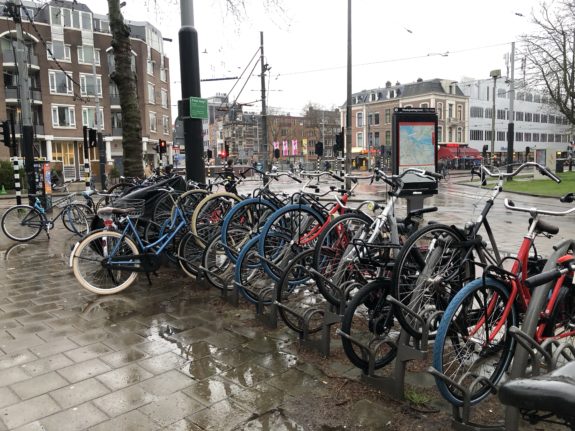
My kid loves to count the bikes with blue front tires here in Amsterdam. And they really are everywhere.
At first I thought it was some kind of style trend, but then I noticed they were all the same brand: Swapfiets, a “bicycles as a service” company with a very interesting business model.
You cannot buy a Swapfiets bicycle. Instead, you can rent one starting at €20 per month for a single speed. If something breaks, the company will come fix it or swap it out for a working one for free. So one big appeal is that users don’t need to worry about surprise repair bills.
We took our five-year-old on her first trip out of the country for a somewhat spontaneous family vacation to Amsterdam. We spotted a surprisingly cheap flight a couple months ago and bought the tickets on a whim. Now we’re here without much of a plan, which is my favorite way to travel.
Adjusting to jet lag is significantly more difficult with a kid. Where adults might just stay up until nighttime on the day of arrival and adjust to the time change all at once, kids can’t really do that it turns out. So at 3:30 this morning, she was wide awake. But this turned into a wonderful experience because we decided to go on a walk together and were able to see the city from a totally different perspective. It was cool to be the only people walking the usually-busy paths through the Rijksmuseum, and we spent some time making funny sounds and listening to them echo around the space. We ate the Oberto jerky we brought as a plane snack, talked about art, found a playground and looked at the water. I think next time I’ll worry less about making the jet lag adjustment all at once and just enjoy being awake during some odd hours. Kids are great at teaching lessons like these.
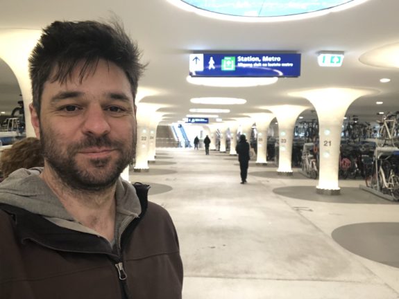
The city has changed a lot since I was last here in 2016. They have mostly completed a massive remake of the area around the Amsterdam Centraal transit station, and it is much less hectic and chaotic than before. It is still hectic, but with a lot more walking space and fewer roads. Buses now serve an elevated area behind the station, so the only transit out front are the trams. They also opened a major new north-south underground metro line that somehow makes getting around even easier, though you do miss out on the city views.
This is something I think about a lot whenever the idea of historic preservation comes up in Seattle. Here’s a city many hundreds of years older than Seattle that is not afraid of constantly evolving. Revisiting past decisions, like building busy roadways in popular areas, is part of running a healthy city.
Also, I did the thing. I visited the city’s new underwater bike parking garage near Amsterdam Centraal. It’s ridiculously cool. This is a wild solution to a problem most cities can only dream of having.
Anyway, this trip isn’t a study trip for the blog or anything, but I’m sure you’ll be seeing more over the next week. Take care.
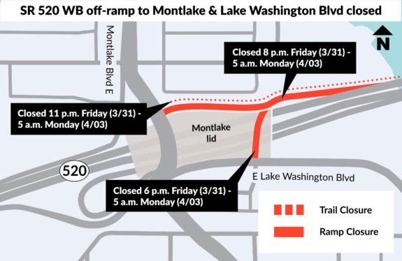
The Duwamish Trail will finally connect to the Spokane Street Bridge in May, SDOT told area stakeholders. Work will begin in early April and, weather permitting, should be be completed in just a couple weeks.
The permanent trail connection will replace the temporary barrel-lined trail constructed during the emergency Spokane Street Bridge closure in January. Though the department removed the 1st Ave S bike lanes after the bridge reopened, they kept the Duwamish Trail connection on West Marginal Way between the bridge and the Duwamish Longhouse.
The new trail will use highway-style concrete barriers similar to the barrier used along Aurora to create the Green Lake Outer Loop bike route. It’s not the prettiest style of barrier, but it is effective, can be installed quickly and is appropriate in this industrial context.
Green Lake Outer Loop on Aurora.
This is great news, and both Mayor Bruce Harrell and SDOT leadership deserve credit for standing behind their Vision Zero goals despite resistance from the Freight Advisory Board. SDOT analysis combined with observation from the temporary trail show only positive impacts to general traffic. Travel times were a couple seconds higher, but that’s only because the amount of speeding decreased. This is a fact that cannot be repeated enough: Bike lanes make streets safer for all users, including people inside cars and trucks. Calming traffic is itself a valuable investment, and it’s even better when transportation departments create and improve bicycle network connections at the same time.
Industry does not need streets to be dangerous in order to operate effectively, and it’s great to see SDOT and Mayor Harrell taking action here where Seattle’s previous mayor failed. I look forward to the opening celebration, which should fall within Bike Month.
For those who have never paid attention to a Washington State legislative session before, we are about to enter the next distinct phase of the session: The budget. The early months of the session are mostly focused on general policy changes, though the budget is always a giant looming over the session. After a series of policy bill deadlines, attention shifts to deal with the money to pay for it all.
Washington Bikes notes in their most recent legislative update that the Senate’s version of the capital budget includes a significant increase for “outdoor recreation, trail development, and state park enhancements.” I like the sound of that.
The Senate and House are also set to release their full budget proposals next week, and WA Bikes is seeking more funding for safe streets as well as e-bike incentives on top of preserving funding for existing biking and safe streets programs. So stay tuned for chances to get involved and show support.
Seattle Bike Blog is not where people usually go to read about light rail station placement debates. But as a Seattle resident who cheers for both an affordable and thriving International District as well as the best transit service we can create, it’s been tough to watch the conversation about station planning for the second downtown light rail line splinter the way it has. And the concerns raise questions that go beyond just this one station, calling into question people’s trust in our region’s government agencies’ abilities to deliver on their promises and lofty equity language.
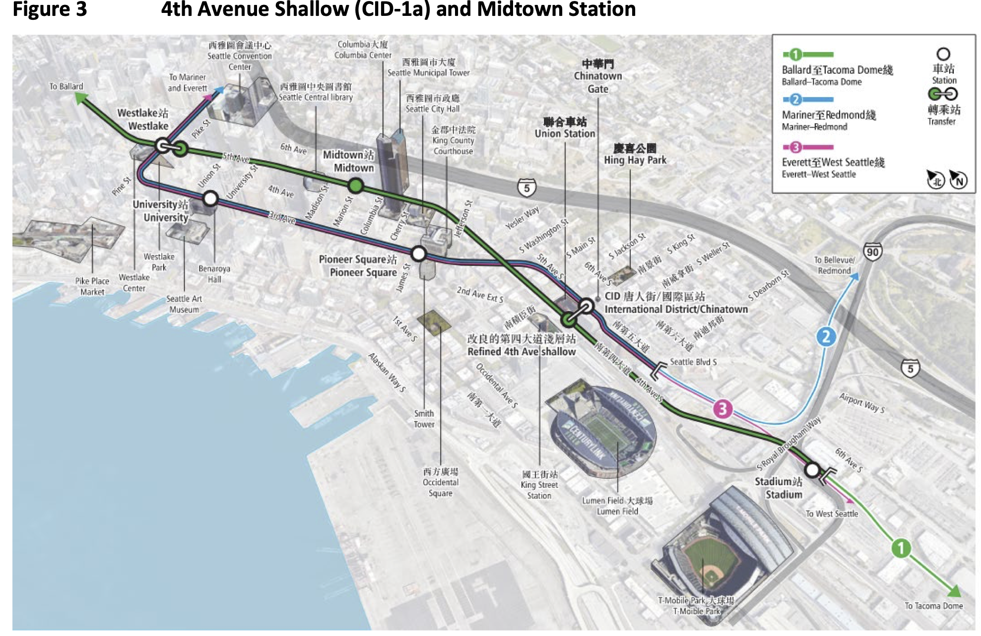
First off, here’s a very high-level and over-simplified summary of the options. Until very recently a shallow or perhaps an even-shallower 4th Ave alignment has been the leading option for a station on the new light rail line through downtown headed to Ballard. New downtown stations would be at 4th/Jackson and 5th/Marion.
From a perspective that prioritizes transit system functionality above all else, a 4th/Jackson station makes a lot of sense. It connects to King Street Station, the Sounder Platform, many buses on Jackson Street and the existing Chinatown-International District light rail station. It even connects to the streetcar if that ever becomes an important transit service worth its investment and headache (foreboding).
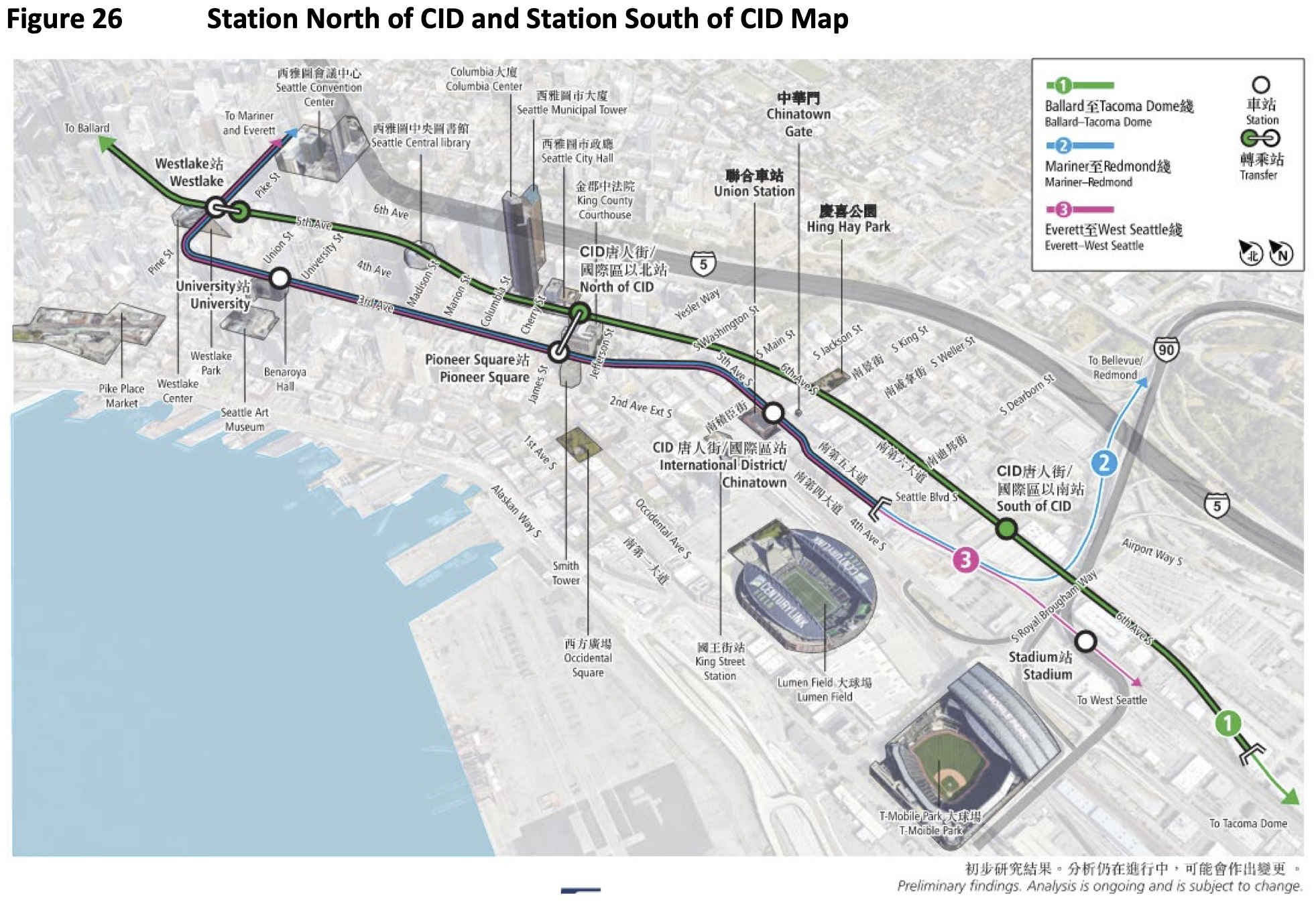
But in recent weeks, momentum has quickly grown for an option that would place new stations on the south end of the ID on 6th Avenue South near Seattle Boulevard and at 5th Avenue near James Street utilizing King County property. This option would use Pioneer Square Station for light rail transfers, but would not directly connect to King Street Station or Sounder service. Deleting Midtown Station at 5th and Marion also has significant implications for station access on First Hill and the retail core of downtown. The 5th and James Station would directly serve Seattle City Hall, which is nice, it would also require walking a couple very steep blocks to reach bus service on either 3rd Avenue, Jackson Street or Madison Street (including the under-construction RapidRide G bus). The idea of a 6th and Seattle station is intriguing because there is a lot of potential for change there, but there are also rail lines and freeway-style roads that may limit usability.