— Advertisement —
  • SDOT is reopening the Spokane Street Bridge, will remove 1st Ave bike lanes Saturday

    Map showing the Duwamish Trail connection staying in place, the 1st ave bike lanes being removed and the spokane street bridge reopening.
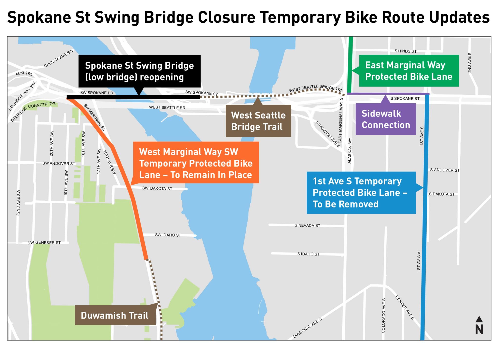
After three weeks stuck in its waterway-priority position, the Spokane Street Swing Bridge to West Seattle will be usable again this afternoon. SDOT noted in an announcement that it should be fully open by 2 p.m. today (Friday).

    This is fantastic news for people who have faced a very long detour via the 1st Avenue Bridge several miles south in Georgetown ever since the swing bridge broke during the winter storm in the days before Christmas.

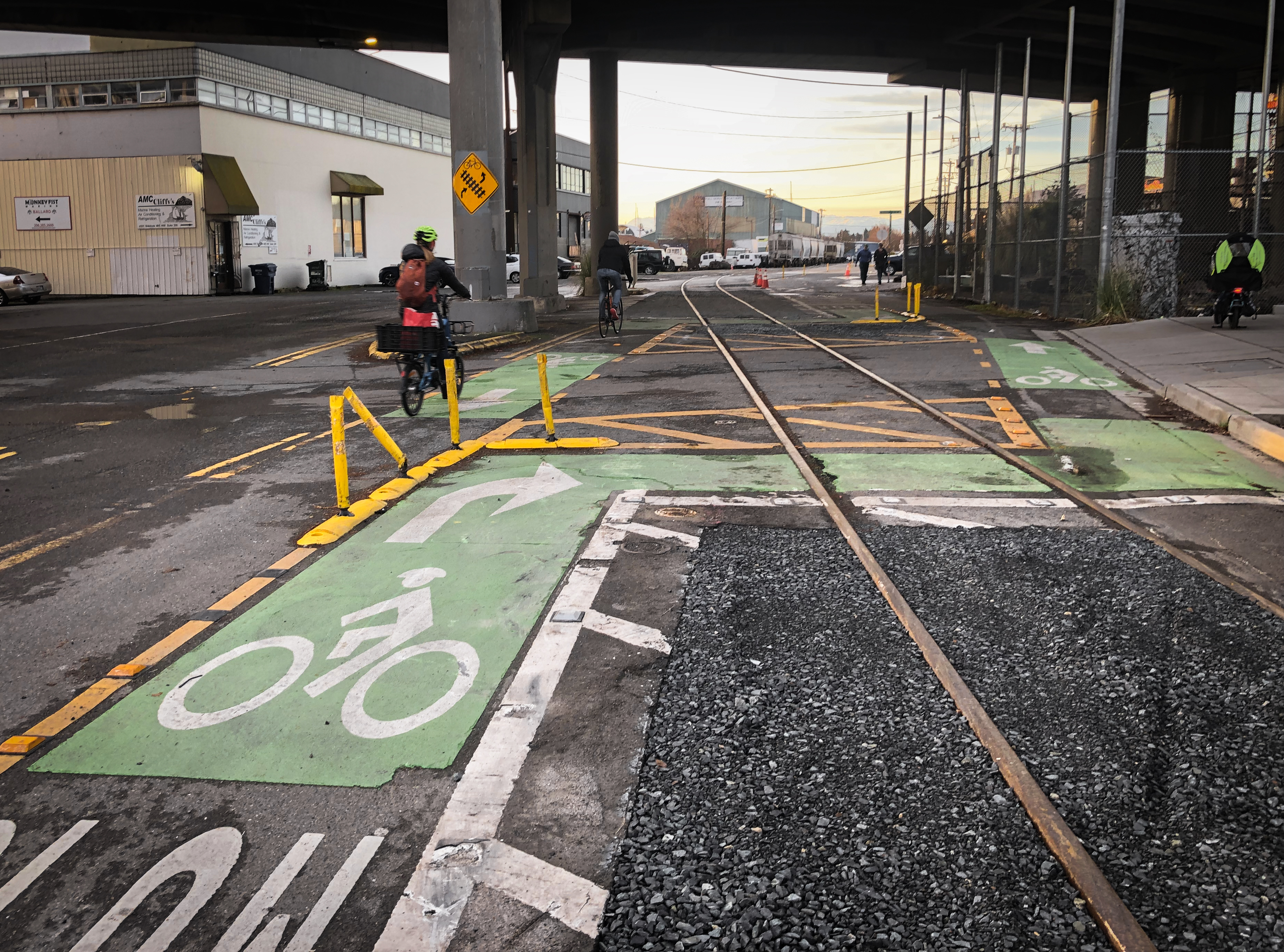
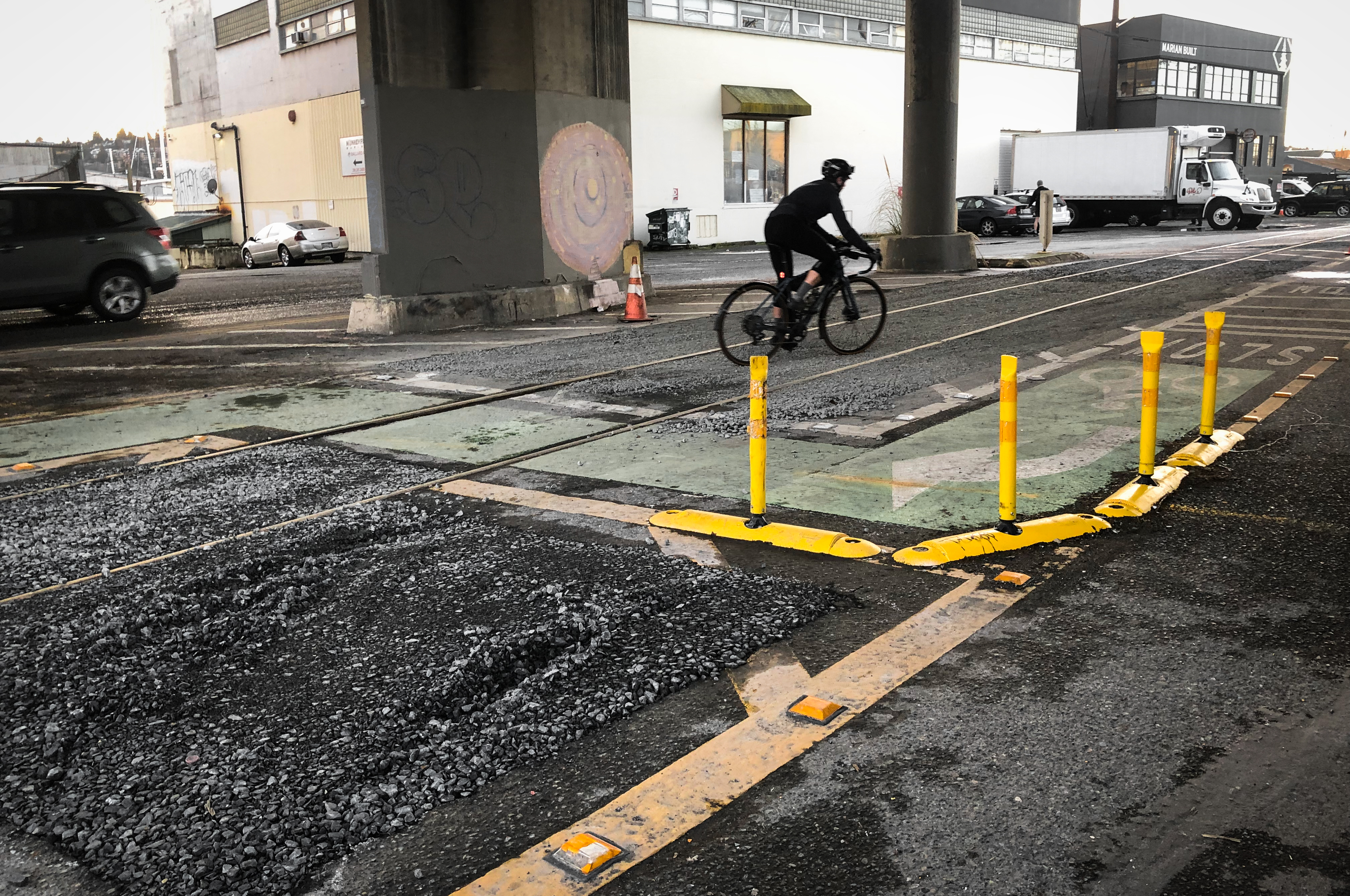
    Sadly, this also means the end of the 1st Ave S emergency bike lanes, which made biking between Georgetown and Spokane Street safe and comfortable for the first time in modern memory. I hope the city gathered useful data from the experiment regarding its impact (or lack thereof) on traffic, vehicle speeds and bike volumes. Seattle Bike Blog has argued for bike lanes on 1st Ave S since the development of the Bicycle Master Plan in 2012–14, and having the opportunity to experience them only solidifies their potential. SDOT staff and Mayor Bruce Harrell deserve a lot of credit for building something quite extraordinary in just a few days. A lot of people worked hard, including during the holidays, to make that happen.

    You still have one final evening to go ride the lanes yourself before crews remove them Saturday. They make Georgetown and other 1st Ave businesses feel so much more accessible and connected.

    The city will not be removing the Duwamish Trail connection along the west side of West Marginal Way SW, which connected the Alki Trail near the Spokane Street Bridge to the Duwamish Longhouse and the Duwamish Trail. This trail connection has been in the works for years and has already gone through a lot of public outreach. It was nearly implemented in the weeks after the upper West Seattle Bridge closure, but the Jenny Durkan administration chose to delay it. So while this Spokane Street Bridge closure has been rough, a connected Duwamish Trail is an excellent parting gift.

    More details from SDOT: (more…)

    — Advertisement —
  • SDOT’s new gravel pits under the Ballard Bridge baffle riders, more changes coming ‘in 2023’

    Person biking the wrong way rather than follow the city's intended route to cross the tracks. Yellow barriers direct people to make a sharp turn.SDOT completed work on an “interim” redesign of the problematic track crossing under the Ballard Bridge for people attempting to bike the Missing Link of the Burke-Gilman Trail, but the new gravel pits sporadically placed in the area seems to be baffling riders rather than helping them.

    People have been crashing on the train tracks consistently for decades as they try to navigate through industrial Ballard after the abrupt end of the Burke-Gilman Trail, and a group of eight injured riders filed a lawsuit against the city last year (full disclosure: Washington Bike Law advertises on Seattle Bike Blog but had no input into this reporting). There are many hazards in the Missing Link area, but the tracks under the Ballard Bridge are the worst. Many people have been seriously injured — left with everything from broken bones to head injuries — after crashing while trying to cross the tracks, which have wide and uneven gaps on either side of them that can surprise riders by grabbing their tires or otherwise knocking them off-balance.

    The safest way to cross the tracks is to move across head-on at a right angle rather than trying to merge across them, and SDOT has redesigned the marked biking paths several times in an effort to encourage right angle crossings. The problem is that the designed turn is too sharp, so people cut the corners to make it more comfortable. So the department’s short-term solution was to … dig gravel pits?

    The idea was to “make the correct route more apparent,” according to an SDOT spokesperson (see full statement below). Since people kept crossing at shallow angles within unevenly paved areas rather than follow the designated bike routing, the department’s hope was that the gravel would deter people from riding through those areas. But it didn’t work.

    Person biking between the tracks through the gravel.I observed people using the new routing for about 20 minutes on a surprise sunny day Tuesday, and a majority of riders in both directions ended up in the new gravel pits. I would estimate that only about 1 in 5 riders followed SDOT’s designed route, and at least one of them seemed unsteady while making the sharp and slow turns necessary to stay within the lines. There was no clear consensus on the best route through the area, and I saw people do all kinds of things. I sketched out a few of the more common choices on this SDOT diagram showing the interim design concept:

    top-down diagram of the gravel pits and preferred bike route with lines showing my observed routes. (more…)

    — Advertisement —
  • SPU plans temporary bikeway during Stone Way overflow pipe construction starting late January

    Map of the detours showing the primary detour route via N 40th Street, Wallinford Ave N and N 34th Street.
    General purpose traffic detour map. Crews will maintain a walking and biking paths through the construction area. Map from SPU.

    Seattle’s least-discussed megaproject is coming to Stone Way in Fremont/Wallingford, but crews have plans to maintain space for biking and walking.

    Seattle Public Utilities’ Ship Canal Water Quality Project is estimated to total $570 million, a cost that could still increase before it is complete, the Seattle Times reported. The project will build large new tunnels and catchment basins designed to prevent “combined sewer overflows” that happen when rainwater overwhelms the sewer system and sends raw sewage into Puget Sound. Eww.

    Part of the project involves a new facility at 35th Ave N and Interlake near the Evo bike shop as well as a new pipe traveling from that facility under 35th and Stone Way. These streets will be closed to general traffic, but a bikeway and sidewalk will remain open along the east side of Stone Way throughout construction. An SPU project manager reached out to alert to Seattle Bike Blog to the upcoming work (thanks, Stephanie!). Construction is set to begin as early as January 30. Details from SPU:

    SPU’s contractor will periodically close the north portion of N 34th St, near the intersection of Stone Way. These closures may make the bike lanes on Stone Way N inaccessible from the south. Cyclists will be asked to detour to other north-south streets or dismount bicycles to travel along crosswalks and sidewalks around the work area. Our contractor will try to schedule N 34th St closures at night, but some daytime closures of N 34th St will be necessary. We will continue to share more information about cycling detours on our project website and email updates.

    Despite being such a large project largely located along the Burke-Gilman Trail route, SPU has really set the standard for bike detours. A few years ago, they detoured the trail in Fremont, and it was reliable and comfortable. This is also the project that has been responsible for the trail detour near the Ballard Fred Meyer. Obviously, it’s not as nice as having the trail open, but it works and is reliable. So I’m hopeful the Stone Way detour will meet the same standard.

    The biggest impact will likely be for people who bike on the detour route, which follows N 40th Street, Wallingford Ave N and N 34th Street. Expect big increases in traffic there. In fact, it might even make sense to take Stone Way if it ends up having lower traffic thanks to this project. Also be ready for increased traffic on other nearby side streets like Woodland Park Ave N, N 36th Street (SPU/SDOT might want to protect the Troll from detour traffic) and Interlake Ave N.

    — Advertisement —
  • Watch: Biking around and feeling hopeful for 2023

    Ride with me as I ramble about some reasons why I think 2023 will be a good year. And please let me know if you like this format for future videos.

    — Advertisement —
  • Neighbors create detailed plan for how the 15th Ave NW paving project can ‘Reconnect Ballard’

    SDOT’s most recent plans for the department’s 15th Ave NW repaving project, which includes the Ballard Bridge, would make very few if any tangible safety improvements for people biking. But neighbors are organizing in an effort to get some key safety improvements added to the $16.2 million project.

    Ballard-Fremont Greenways created an effort they call “Reconnect Ballard,” a detailed document (PDF) filled with good idea for making the area around the project safer for all road users while also improving safety and accessibility for people walking, biking and rolling. It also includes relevant citations to Seattle plans and policies — including the Bicycle and Pedestrian Master Plans and the Complete Streets Ordinance — that the project currently fails to meet. You can send a letter to elected leaders and SDOT staff supporting Reconnect Ballard using their handy online tool. You can also complete SDOT’s online survey before it closes January 13 (Friday), though it is more to give them data for minimizing construction impacts and does not directly address safety improvement.

    In the SDOT project page’s frequently asked questions section, the answer to why there are no bicycle improvements in this project is short: “Bike facilities on the Ballard Bridge are outside the scope of this project.” Seattle’s complete streets ordinance begs to differ, however, however, stating that “SDOT will plan for, design and construct all new City transportation improvement projects to provide appropriate accommodation for pedestrians, bicyclists, transit riders, and persons of all abilities, while promoting safe operation for all users.” The ordinance includes a list of exceptions, but none from my reading would preclude most of the suggested improvements in the Reconnect Ballard document. If I’m reading it correctly, the project will need “documented exception” from the Director of Transportation to move forward legally.

    Perhaps the biggest single project addition Ballard-Fremont Greenways seeks is to add a crosswalk signal at NW 51st Street to help people cross the pseudo-highway. The group also suggest building a railing on top of the barrier between the roadway and the sidewalks. They also have ideas for creating a safe crosswalk at W Emerson Street for people using the west sidewalk on 15th. The most recently-released 60% design would leave the notorious “merge of death” in place, which is frankly unacceptable and one of the more clear-cut examples of how the project does not meet the legal requirements in the Complete Streets Ordinance.

    Google Street View image of the so-called merge of death, a cut out in the cement barrier between the sidewalk and street. Someone trying to continue south would need to walk or ride in traffic.
    Anyone using the sidewalk who wants to continue south on 15th must use this cutaway in the barrier to do so. A “Yield to Bicycles” sign feels rather feeble in the presence of the Merge of Death. Via Google Street View.

    Their proposed solution would be something like this: (more…)

    — Advertisement —
  • Trail will remain open during weekend 520 Bridge construction

    Overview map of the final design plan for the Montlake area, featuring a trail via a landbridge over 520 and a trail tunnel under Montlake Blvd.
    The final design for Montlake once construction is finally complete in a few years. From WSDOT.

    The trail on the 520 Bridge will remain open this weekend even as all lanes are closed to motor vehicle traffic. That motor vehicle closure is scheduled to extend from 11 p.m. Friday (today) until 5 a.m. Monday.

    If you’ve never biked across the 520 Bridge when there is no car traffic, I highly recommend it. Stopping mid-span is so much more peaceful and quiet, the kind of mid-lake experience you can usually only get on a boat. So this weekend you can bike to Georgetown via the 1st Ave S temporary bike lanes, then head all the way up to a car-free 520 Bridge. Sounds like a pretty great set of weekend plans to me.

    — Advertisement —
— Advertisement —

Join the Seattle Bike Blog Supporters

As a supporter, you help power independent bike news in the Seattle area. Please consider supporting the site financially starting at $5 per month:

Latest stories

— Advertisements —

Latest on Mastodon

Loading Mastodon feed…