— Advertisement —
  • I-90 Trail will remain open during weekend westbound bridge closure

    The I-90 Bridge will remain open this weekend during expansion joint work on the Homer Hadley Bridge that will close all westbound lanes.

    We reported last week on a series of tough planned trail closures on the larger of the two floating bridges between Mercer Island and Seattle. WSDOT later apologized for the poor communication about the trail work and worked to find last-minute ways to minimize the impact on people biking and walking who cannot easily reroute around the closed bridge.

    Now WSDOT has announced that the trail will remain throughout the work, which is set to run Thursday through Sunday.

    This is fantastic news. Instead of a trail closure, we might get the most pleasant weekend on the I-90 Bridge in recent memory. It’s not often you get to experience the bridge without the constant rush of nearby cars kicking up dust and making noise.

    — Advertisement —
  • A Week Without Driving starts today + Read this excellent op-ed

    A Week Without Driving is fairly straightforward: It’s a challenge that asks people who typically drive to go a week without using their car. It can be a powerful experience for individuals who take it on.

    But the Disability Mobility Initiative at Disability Rights Washington is not only challenging the general population, they purposefully reach out to people in positions of power over how our streets, transit systems and budgets work. They also center the action around people across the state who cannot drive, whether due to disability, age, income or any other reason. This gives the challenge a different feel than similar efforts like Cascade’s annual Bike Everywhere Challenge, which encourages people to choose to try biking. For A Week Without Driving, it’s about people who don’t have that choice.

    There are people in every Washington community who cannot drive. While there are pockets of the state with quality transit, biking and walking conditions, people everywhere need access to convenient mobility. So Disability Mobility Initiative did not only reach out to political and transportation leaders in dense urban areas. They reached out to leaders in suburban and rural areas as well. This could be a great opportunity for folks to engage their local leaders on issues affecting people who don’t drive, so check your local leaders’ social media pages to see if they are taking the challenge.

    You can sign on to the challenge online. I also highly recommend reading this excellent op-ed by Disability Mobility Initiative organizer Anna Zivarts in the Stranger:

    Rather than minimizing the mobility needs of those of us who can’t or don’t drive, we should be celebrating and encouraging nondrivers, especially those young people who understand the extraordinarily high costs of car dependence and who are choosing not to feed into this dysfunction.

    For people who have spent decades centering their lives around vehicle ownership, it may be impossible to imagine our country without car-dependent mobility. But those of us who are nondrivers are already working towards a different future. A future where you don’t need to worry that your car payment eats one-third of your paycheck, where you can let your kids walk to school on their own because there are sidewalks the whole way, where the light rail station is surrounded by affordable apartments rather than parking garages. A future where you could get from one rural community to the next because we run rural bus routes or rebuild our rail network, where you can still get to all our national parks even if you don’t have a car.

    Read more…

    — Advertisement —
  • Help WSDOT’s Active Transportation Plan defeat a bunch of highway plans to win a national award

    Can a Washington State plan centered around walking, biking and accessibility defeat a bunch of highway and bridge projects to win the 2022 America’s Transportation Award? Well, it can with your help.

    Remember those annoying “people’s choice” competitions that were everywhere like a decade ago where you had to vote every day in order to help your favorites bakery or whatever win? This is one of those, except it is sponsored by AAA, the U.S. Chamber of Commerce, and the American Association of State Highway and Transportation Officials (“AASHTO”). This award usually goes to highway megaprojects like the 2020 winner: The SR-99 highway tunnel. So yes, I am suggesting that you should bookmark this page and vote every day until October 21 for the “Active Transportation Plan 2020 and Beyond.”

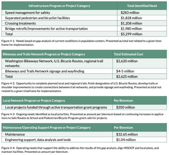
    No, this award isn’t the biggest deal in the world, but it would be delicious for this kind of plan to defeat a bunch of major highway projects. It could also bring some much-deserved attention to the plan, which got buried in the news thanks to the pandemic and, you know, everything else that was happening in 2020 and early 2021 when it was seeking public feedback and attention. The plan is really great and attempts to quantify something that most states have never considered: What would it cost to make all state-run highways safe for people walking and biking? The answer for Washington is counted in billions:

    Cost estimate summary tables showing billions for sidewalks, retrofits, trails and more.These totals are simultaneously a lot of money and also not too out of place among the typical highway megaproject. For the cost of the SR-99 tunnel and the 520 Bridge Replacement Project, Washington State could pay for the entire statewide Active Transportation Plan. With pedestrian fatalities skyrocketing across the nation and especially in Washington State, the pricetag looks reasonable. Since you can’t really buy something without a pricetag, we have this plan to thank for putting some numbers and strategies behind the problem.

    Perhaps the top reason for voting for this plan is that the national attention could encourage other states to create their own active transportation plans and come up with their own lists of costs and strategies. It’s long past time for states to put the same kind of serious money behind walking, biking and accessibility as they do for highways.

    — Advertisement —
  • Trail Alert 9/16-19 and 9/23-26: I-90 Bridge Trail will be closed between Seattle and Mercer Island – UPDATED

    UPDATE 9-21: The trail will remain open during the September 23–26 work.

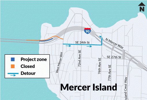
    Map of I-90 closure near the west approach to Mercer Island.
    Map of the closure from WSDOT.

    WSDOT sent out an alert today that the trail across the I-90 Bridge will be closed most of Friday and all weekend as crews work on an expansion joint on the Homer Hadley Bridge, the wider of the two parallel I-90 floating bridges.

    The trail will be closed starting at 10 a.m. Friday (September 16), so you will need a different way to get home in the evening if you bike across it in the morning.

    People biking and walking will need to route either around the lake or to the 520 Bridge. There is no official detour route, though the Lake Washington Loop is a popular option (Cascade Bicycle Club has created a map for reference). There is also a popular route through Bellevue and Medina that sticks closer to the water. If you ever need to detour along an unfamiliar route, you can find popular routes by checking out the Strava and Ride With GPS heatmaps. Just note that both these routes between the bridges require riding in mixed traffic.

    Details from WSDOT:

    Sept. 16-19 closure
    The first weekend’s work requires crews to close the West Mercer Way on-ramp to westbound I90. People on Mercer Island still will be able to get onto westbound I90 via the East Mercer Way and North Mercer Way on-ramps.

    In addition to closing the West Mercer Way on-ramp on Friday, contractor crews also will close the right lane of westbound I90. The right half of the expansion joint runs across the right lane through the on-ramp and across the bike path, which also will be closed for the weekend.

    Sept. 23-26 full closure – two lanes closes Sept. 22
    This closure actually will start with westbound I90 reducing to one lane on Mercer Island at 2 p.m. Thursday, Sept. 22. All lanes will then close at 10 a.m. Friday, Sept. 23 (the on-ramp from West Mercer Way will remain open to westbound I90.) All lanes will reopen by 5 a.m. Monday, Sept. 26.

    — Advertisement —
  • City set to begin work to complete the Green Lake Outer Loop, should open by December

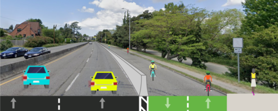
    Concept image of the Aurora bike path with crude drawings of people biking within a barrier-protected lane.
    Green Lake & Wallingford Safe Streets created this graphic to show their concept. Now it’s happening for real.

    It’s happening. Work to complete the Green Lake Outer Loop will begin “this month” and should be open by December.

    The community-generated concept would repurpose a non-continuous lane along the east side of Aurora Avenue, turning it into a walking and biking trail with a sturdy barrier protecting it from Aurora traffic. It will at least partially restore a route that has been missing for nearly a century, ever since traffic engineers tore through Woodland Park and the side of Green Lake to build Aurora Avenue. The bikeway will also make the gravel and dirt pathway next to Aurora a lot safer and more comfortable for people walking and running by creating a barrier and buffer space.

    You can find detailed designs in our previous post. But once complete, people will be able to bike a full loop around Green Lake, which has long served as a nexus for north end bike routes. The Outer Loop will only make that role more clear and will open the bike network to more neighborhoods west of the lake. It could also take some pressure off the lakeside path, which had long had crowding issues.

    Green Lake & Wallingford Safe Streets deserves a lot of credit for promoting this idea and organizing support.

    This project is a very worthy improvement to the bike network. But we need this same urgency and creative repurposing of existing infrastructure in South Seattle, too. Lake Washington Boulevard is the most obvious place to start, but there are many opportunities to make improvements that will help people bike and walk safely and comfortably even if they don’t live near Green Lake. It’s not a zero-sum situation where Green Lake got bike lanes at the expense of South Seattle, but can you blame people for perceiving it that way? The problem isn’t a lack of funding, it’s a lack of political will. The city needs to see that SDOT and city political leaders are serious about making equitable investments in safe streets.

    Bike advocates have been arguing consistently that the city needs to prioritize bike network improvements in the south end. It’s been a monthly refrain out of the Seattle Bicycle Advisory Board for at least a decade. Under Mayor Jenny Durkan, advocates had to drag the mayor and SDOT kicking and screaming toward a more equitable bike plan, which they got thanks to Council action. It’s not a bad thing that Green Lake is getting a full bike loop, but it’s extremely frustrating that there is so little urgency to make similar improvements in South Seattle. There are some good things happening, like the Georgetown to Downtown bike route, but that won’t even break ground until 2024. People need safer walking and bike routes now. Investing equitably means that places like Rainier Valley that have been historically under-served by city and state safe streets improvements need even more attention than places like Green Lake with a long history of such investments.

    — Advertisement —
  • SDOT survey asks if they should improve the bike lane south of U Bridge (yes, obviously) – UPDATED

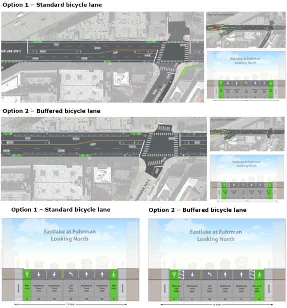
    Diagrams comparing the painted bike lane option 1 to the buffered bike lane option 2.
    The answer is obvious. Take the survey and support Option 2.

    Whatever you are doing, stop and fill out this quick survey to support safer bike lanes on Eastlake as part of the RapidRide J project. You can also attend one of two virtual community design sessions Wednesday from 12–1:30 p.m. or 6–7:30 p.m. (register here).

    There are three major questions pertaining to bike safety in the survey. But let’s start with the highlight: The block south of the U Bridge. The current plan would maintain the existing skinny, paint-only bike lanes, and we have written repeatedly arguing that the project needs to add more protection. So it is very exciting to see Option 2, which widens the bike lane and adds some buffer space. This would be a huge improvement over the previous plan, though it would be best if there were some protection to prevent people from parking in the bike lane.

    Maps showing bike intersection options. The survey also presents four options for the intersection at 11th Ave NE and NE 43rd Street. At this point, the bike lane had been planned to switch from the right side of the one-way northbound street to the left side, though that decision was made when the RapidRide line was going to run all the way Roosevelt Station or even Northgate Station as was the original plan. The idea was to reduce conflicts with the RapidRide bus stops and the bike lane.

    However, the bus line now ends at NE 43rd street, which calls into question whether the bike lane should switch sides at all. Unfortunately, that is not one of the options presented. If nothing else, this intersection change requires the city to also have a full 11th/12th Ave NE bike lane ready to build at the same time that will need to reach NE 75th Street, where the bike route shifts to two-way on Roosevelt. If the left side bike lane doesn’t reach 75th, then there will need to be another transition somewhere along the way, which would be absurd. (more…)

    — Advertisement —
— Advertisement —

Join the Seattle Bike Blog Supporters

As a supporter, you help power independent bike news in the Seattle area. Please consider supporting the site financially starting at $5 per month:

Latest stories

— Advertisements —

Latest on Mastodon

Loading Mastodon feed…