— Advertisement —
  • Sunday: Bike Works hosts Tour de Fleurs alleycat ride

    NOTE: You can find this event and more on the Seattle Bike Blog Events Calendar. Posting to the calendar is free and open to anyone. For example, check out this East Seattle History Ride Saturday.
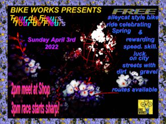
    Event poster for Tour de Fleurs.Bike Works is hosting a flower-themed alleycat Sunday with “a wide array of jovial checkpoints and challenges based on non-bike related talent and luck.” An alleycat is a style of bike ride with a set of checkpoints around town, but no set route. Instead, it’s up to riders to navigate their way from point to point completing challenges along the way.

    So bungee some flowers to your bike and head down to the Bike Works community shop at 2 p.m. It’s a free event.

    Details from Bike Works:

    The dark, gray days are almost over, and life finds a way to light up our path towards a brighter, warmer future in the way of flowers. Rejoice! Spring is upon us! And what better way to celebrate than with a bike ride? Bike Works will be hosting its first official alleycat-style bike ride, the Tour de Fleurs, in celebration of spring – rain or shine!

    Tour de Fleurs
    Sunday, April 3rd, 2 – 6 PM
    Bike Works Shop – 3709 S Ferdinand St, Seattle, WA 98118
    Two route options – 13ish + 17ish miles with a 2 hour limit
    Register here – optional donations will support Nurturing Roots

    An alleycat is a bike race modeled after a day in the life of a bike messenger. The route will be kept secret until the day of. There is no set route; it is up to the rider to navigate their own path. In addition to the urban asphalt, there will be dirt/gravel options to increase stoke and help connect you to the great provider of flowers and life, Mother Earth.

    We’ve planned the ride to celebrate and encourage fun with a wide array of jovial checkpoints and challenges based on non-bike related talent and luck. Optional dress code is floral spring awakening. Prizes given for mini-game challenges, best dressed, fastest, slowest, etc. Food and drink will be provided.

    We hope to see you on Sunday for an amazing celebration of warmer, brighter days ahead.

    — Advertisement —
  • Study: 1930s maps of racist redlining predict air pollution levels today

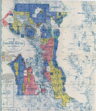
    The HOLC map of Seattle from 1936.
    Home Owners’ Loan Corporation map of Seattle.

    In news that is both horrible and unsurprising, a team of researchers from UC Berkeley and UW in Seattle have published a study demonstrating that “redlined” areas of cities marked in federal maps from the 1930s had higher levels of air pollution in 2010.

    Redlining was the discriminatory practice of withholding loans or other private and public investments from certain areas within cities based largely on the race of the people living there. Redlining was legal in Seattle until 1968, though the legacy of the practice continued in many forms even after it was outlawed by city ordinance. Though the practice of withholding investments or properties from people of color long predates 1930, that was when the federal government commissioned a set of maps from cities around the country, including Seattle, to rate the “security” of mortgage investments in different areas of each city. The Home Owners’ Loan Corporation (“HOLC”), which was tasked with helping struggling homeowners during the Great Depression to refinance their mortgages, created maps that illustrated and codified existing prejudices and racist practices. Communities of color were often rated as “Hazardous” and given a “D” grade. “A” grades were mostly reserved for wealthier and whiter communities.

    HOLC did not invent the racist practices behind redlining, but they did make it very obvious by drawing the lines on public maps. Researchers today can now use those same maps to learn how segregationist practices a century ago affect communities today. And that’s exactly what the researchers did in this new study. They compiled a huge database of census blocks that included 2010 air pollution levels as well as the 1930s HOLC grade, then looked for correlations. Nationally, areas with “D” grades in the 1930s had 56% higher levels of nitrogen dioxide in 2010 than “A” graded areas.

    There are many mechanisms leading to this air quality disparity, but they all add up to racist results because that’s what happens when there is wide-reaching systemic racism. Poor air quality can come from many different sources, though the worst of it comes from highways and polluting industry. Freeways and other wide highways were often purposefully routed through redlined areas as a form of so-called “Urban Renewal,” which James Baldwin called “Negro Removal.” Freeways are a major source of nitrogen dioxide pollution. Wealthier and whiter areas have also had more means and political connections to fight the incursion of polluting industry into their neighborhoods, preserving the clean air quality in “A” graded areas.

    This is why projects like South Park’s SR-99 removal project are so important, and just the beginning of the work needed to try to heal the wrongs of the past.

    The Seattle Times put together a set of maps demonstrating the study’s findings in Seattle: (more…)

    — Advertisement —
  • Feds recommend $60 million for RapidRide J project, including Eastlake Ave remake

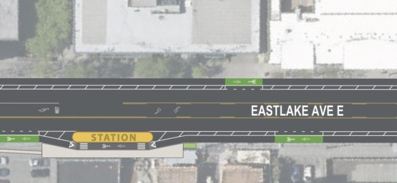
    Excerpt from the design concept maps showing new floating bus stop and protected bike lanes.
    Design concept for Eastlake Ave E (PDF).
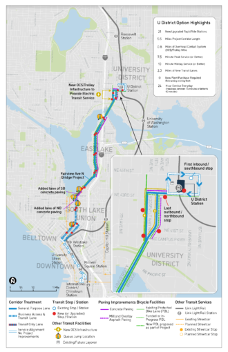
    Full corridor map.
    From SDOT.

    The Federal Transit Administration has recommended a $60.1 million grant to fund the RapidRide J project from the U District to South Lake Union via Eastlake.

    “Coupled with funding from the Levy to Move Seattle that voters approved in 2015, the recommended $60 million grant would fully fund the RapidRide J Line project,” said Seattle Mayor Bruce Harrell in a joint press release with King County Metro. “Access to transit and safe streets are the things that make a difference in people’s life. This type of infrastructure makes our city welcoming to people of all ages and abilities and connects them to work, schools, recreation, and culture – creating One Seattle.”

    The RapidRide J project is a major remake of the corridor, including long-awaited protected bike lanes on Eastlake Ave E and Fairview Ave N. We previously talked through the design details in great detail. Hopefully the $60 million is enough to fix the lacking bike protection at the south end of the University Bridge, one of the few lacking elements in a very exciting design that will make biking much more comfortable in this vital corridor.

    More details from USDOT: (more…)

    — Advertisement —
  • Without waiting for outer loop path due this summer, Parks Department issues ‘long-term temporary’ ban on bikes at Green Lake

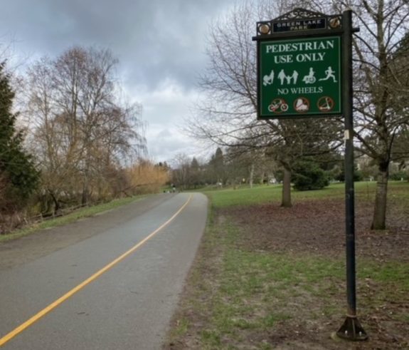
    Photo of a sign that says "pedestrian use only, no wheels"
    Photo from the Parks Department.

    Without waiting for SDOT to complete its “outer loop” bike connection around Green Lake, the Seattle Department of Parks and Recreation banned biking from the popular lakeside trail.

    “This long-term temporary use restriction, which restricts all bicycles and other wheeled uses from the Green Lake Park inner loop (strollers and mobility devices are allowed), is intended to create more space for path users on this high use trail,” wrote the Parks Department in a blog post announcing the change. But without SDOT’s planned outer path, people biking now have no comfortable option for traveling along the west side of the lake. Regardless of whatever “long-term temporary” means, signs are now in place with icons of bikes, roller skates and scooters crossed out in red. People can submit feedback on the rule change to [email protected].

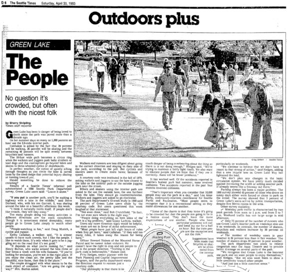
    Newspaper clipping with photo of people walking and biking on the green lake path. Headline: Green Lake: No question it's crowded, but often with the nicest folk.
    News clipping from the April 30, 1983 Seattle Times shows that people have been talking about crowding on the Green Lake Path for decades. Read the full article (Seattle Public Library card required).

    There is a lot of history leading up to this point. People have argued off and on about banning biking on the path for decades. The Seattle P-I asked readers in 1979 (Seattle library card required) whether biking and roller skating should be banned from the path. The majority of respondents said no, but one reader said, “Ban everybody, I say. The public has enjoyed Green Lake long enough. One would think the public owned it.” In 1980, the Parks Department even surveyed users about whether something should be done about it. People at the time said to leave it alone, according a 1983 article in the Seattle Times.

    The Green Lake path was once among the most popular destinations in the city for people looking for a nice place to bike because, just like now, many people simply did not feel comfortable mixing with car traffic on city streets. Countless young Seattleites learned to ride a bike on the path. It’s an extremely pleasant place, at least when you don’t get stuck in a big summer weekend crowd. Over the decades, there have been many efforts in the past to ease congestion on the path. The longest-lasting solution was the one in place until very recently: A divided path with foot traffic on one side and “wheels” on the other. While people on foot were allowed to go either direction, wheels were only allowed counterclockwise. This never worked perfectly, but it was a compromise.

    Today, there are many places to ride a bike in Seattle other than this one path. There are even bike lanes on the street not far from the path for about two thirds of the lake. But there still is no bike route on the western edge of Green Lake, leaving the lakeside path as the only obvious and direct option for people traveling there. (more…)

    — Advertisement —
  • Saturday: Seattle Neighborhood Greenways community potluck at Gas Works Park

    Bring some snacks or a side to Gas Works Park Saturday afternoon for a safe streets potluck with Seattle Neighborhood Greenways. It’s officially dubbed a “volunteer picnic,” but everyone is invited whether you have volunteered or not.

    You can also join a group ride to the picnic. One leaves Capitol Hill Station at 12:30, and another leaves Columbia City Park (near PCC) at 11:30.

    Details from SNG:

    Join Seattle Neighborhood Greenways to celebrate another year of fabulous grassroots community power!
    Saturday, March 26, 2022, 1:00 – 3:30 pm
    – – –
    EVENT DESCRIPTION:
    Drop in to catch up with old friends and neighbors or meet and greet with new folks. Learn about local advocacy, grab some swag or a bike or walking map.

    We’ll provide some food for the grill, bring potluck snacks or sides to contribute if you can.

    All are welcome — you don’t have to had volunteered with us before to come celebrate!
    – – –
    GETTING THERE:
    Gas Works park is located at 2101 N Northlake Way, Seattle, WA 98103 and is accessible from the Burke Gilman Trail or a short (steep) walk from the 31, 32 or 62 bus. The park also has free car parking.

    We will be at the picnic area on the northeast side of the park, behind the restrooms. The picnic area is wheelchair accessible.
    Stay tuned for more info on group bike rides to the event! (or lead one yourself!)

    GROUP RIDES:
    From Capitol Hill:
    Stefanie and Ethan will be leading a family-friendly CSG group ride to the Gas Works picnic from Capitol Hill on Saturday. All are welcome!

    We’ll meet at 12:15p at the Barbara Bailey Way plaza outside the Capitol Hill light rail station (where the farmer’s market is on Sundays). Roll out at 12:30p.

    Our route mostly follows quieter streets. We’ll head through the beautiful Interlaken Park to Eastlake, the University Bridge, and the Burke-Gilman Trail. Route here: https://tinyurl.com/suha8jnd

    From Rainier Valley:
    Meet up with Jason from Rainier Valley Greenways-Safe Streets at Columbia City Park next to PCC at 11:15 am, roll out 11:30, and meet up with the Central Seattle Greenways group for the remainder of the trip. Rough route here: https://tinyurl.com/498wfbk7

    — Advertisement —
  • For the first time since 2019, the Fremont Solstice Parade returns June 18

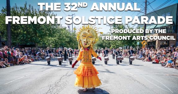
    Photo of a person in a sun costume in the middle of a street.
    Image from Fremont Fair.

    I am so happy to hear that the Fremont Solstice Parade is back. June 18, mark your calendars.

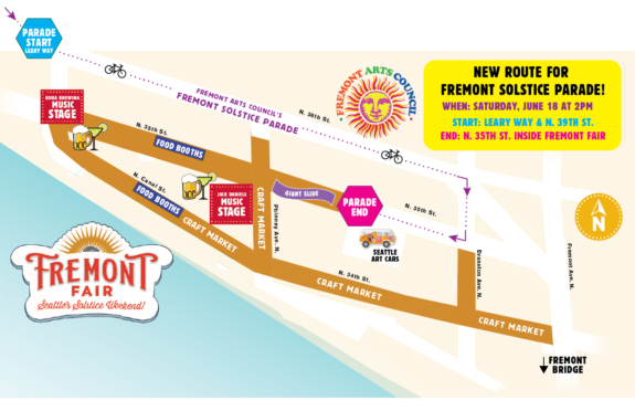
    The maps even have bicycle icons printed on them! Does this mean the years of the Fremont Arts Council resisting the naked painted bike parade are officially over? I sure hope so.

    For anyone who has never had the pleasure of witnessing (or participating in) the Fremont Solstice Parade, you are in for a treat. It might be the best day of the year in Seattle. The city welcomes the seemingly neverending sun with a wonderful display of creativity.

    The whole parade is wonderful, but the best-known part started as a prank in the 1990s when a couple people got naked and streaked ahead of the parade on their bikes. The tradition of biking naked before the parade built slowly through the 90s until 1998, when Seattle Police decided to crack down on the tradition and arrested a rider. The arrest drew boos from the crowd, and kicked off a big debate in the city about puritanical thinking that then-Councilmember Nick Licata described as “a defining moment” for Seattle. I have a whole section about the history of the Solstice bike ride in my upcoming book (which will definitely be complete some day I promise). I also highly recommend the 2013 documentary Beyond Naked all about the tradition.

    Anyway, back to 2022. It’s been 33 months since the last IRL Solstice Parade, and our city is in desperate need of the joy and community it brings. The 2022 route is currently slated to be shorter than in previous years, and it looks like it may even avoid closing the Fremont Bridge. Instead of heading to Gas Works Park, the route will end at Evanston inside the Fremont Fair grounds. This makes a lot of sense for the proper parade, which is a very slow-moving, people-powered spectacle. I’m sure are still working out the logistics for the bike ride, so stay tuned.

    Map of the Fremont Fair 2022.
    Map of the parade route, via MyBallard.

    (more…)

    — Advertisement —
— Advertisement —

Join the Seattle Bike Blog Supporters

As a supporter, you help power independent bike news in the Seattle area. Please consider supporting the site financially starting at $5 per month:


Latest stories

Bike Events Calendar

Jul
25
Thu
7:15 pm Point83 @ Westlake Park
Point83 @ Westlake Park
Jul 25 @ 7:15 pm
Point83 @ Westlake Park
Meet up in the center of the park at 7ish. Leave at 730. Every Thursday from now until forever rain or shine. Bikes, beers, illegal firepits, nachos, bottlerockets, timetraveling, lollygagging, mechanicals, good times.ShareMastodonTwitterFacebookRedditEmail
Jul
27
Sat
all-day Bicycle Weekends on Lake Washing…
Bicycle Weekends on Lake Washing…
Jul 27 – Jul 28 all-day
Bicycle Weekends on Lake Washington Blvd
Details from Seattle Parks: On scheduled weekends from May to September, a portion of Lake Washington Boulevard will be closed to motorized vehicles from 10 a.m. Saturday to 6 p.m. Sunday. “Seattle Parks and Recreation[…]
Jul
28
Sun
all-day Bicycle Weekends on Lake Washing…
Bicycle Weekends on Lake Washing…
Jul 28 – Jul 29 all-day
Bicycle Weekends on Lake Washington Blvd
Details from Seattle Parks: On scheduled weekends from May to September, a portion of Lake Washington Boulevard will be closed to motorized vehicles from 10 a.m. Saturday to 6 p.m. Sunday. “Seattle Parks and Recreation[…]
Aug
1
Thu
7:15 pm Point83 @ Westlake Park
Point83 @ Westlake Park
Aug 1 @ 7:15 pm
Point83 @ Westlake Park
Meet up in the center of the park at 7ish. Leave at 730. Every Thursday from now until forever rain or shine. Bikes, beers, illegal firepits, nachos, bottlerockets, timetraveling, lollygagging, mechanicals, good times.ShareMastodonTwitterFacebookRedditEmail
Aug
8
Thu
7:15 pm Point83 @ Westlake Park
Point83 @ Westlake Park
Aug 8 @ 7:15 pm
Point83 @ Westlake Park
Meet up in the center of the park at 7ish. Leave at 730. Every Thursday from now until forever rain or shine. Bikes, beers, illegal firepits, nachos, bottlerockets, timetraveling, lollygagging, mechanicals, good times.ShareMastodonTwitterFacebookRedditEmail
— Advertisements —

Latest on Mastodon

Loading Mastodon feed…