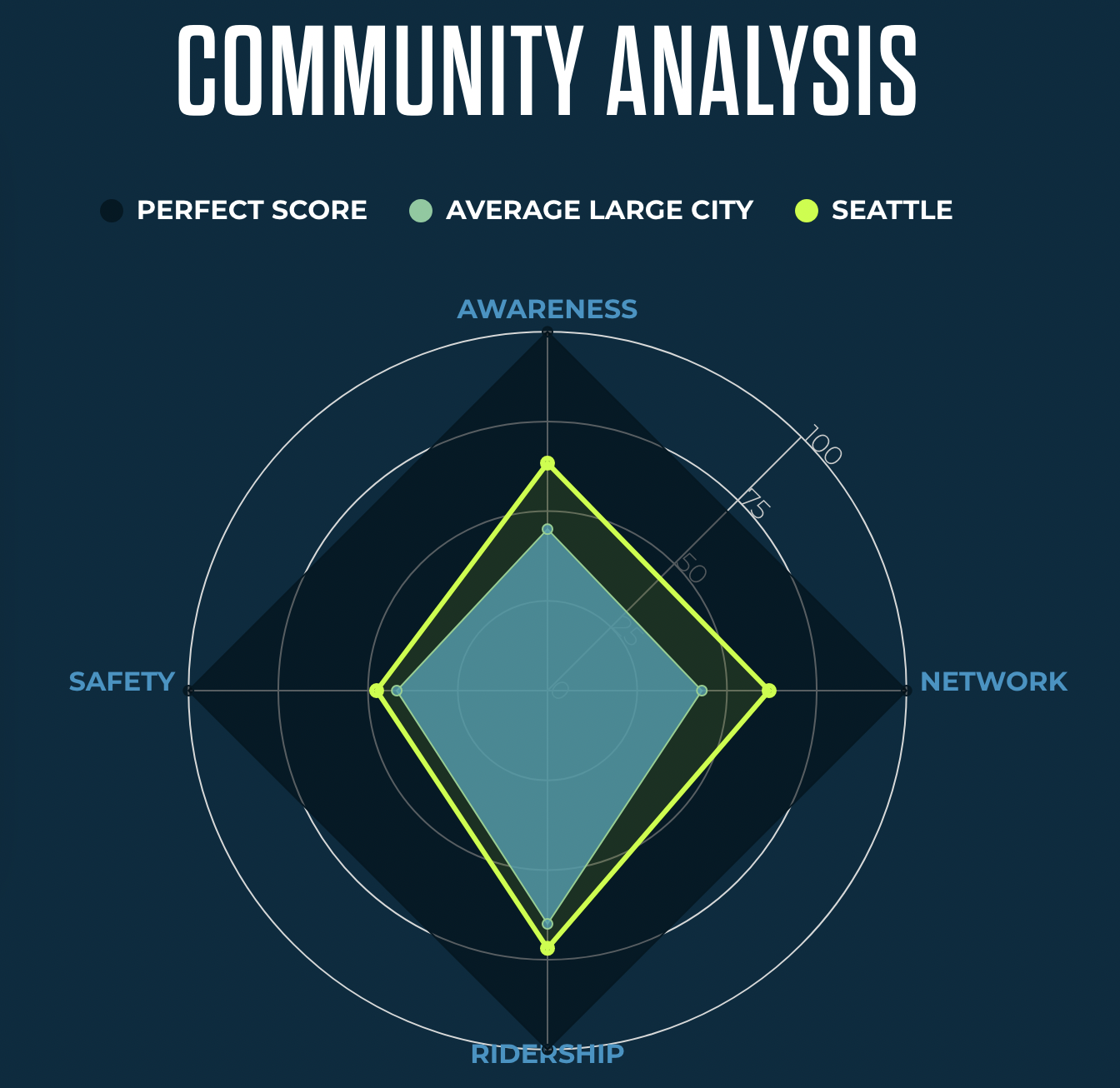
These rankings are of course a rather imperfect science, but they’re interesting (NOTE: The Seattle page says it is the #4 big city, but their list of big cities puts Seattle at #3. I’m going with #3 since I can’t figure out what the 3rd city in front of Seattle would be). People For Bikes created a list of criteria based on the existing bike network, ridership, safety and some community response elements such as “how safe people feel riding a bike in their city.” Here’s a visual of Seattle’s results:
They also have a bike network analysis tool that spits out a map of “how well bike networks connect people with the paces they want to go.” That’s a pretty tough goal to reliably measure, but it’s interesting to explore their results:
I made a Sound Transit piano. I don’t know why I did it, but I did. So then I wrote a song. Then I made a video for that song. I have no regrets.
The samples were from a public disclosure request by Kevin Wallace back in 2016. He requested all the audio files from Sound Transit’s light rail service, and then posted the files online. I for some reason took those files and dropped them into the Cubase drum sampler Groove Agent so that I could play Samantha’s robotic voice on my piano. My train-loving four year old had a good time playing it. So did I.
After spending some time with the tracks, I realized that Samantha sure talks a lot about doors. So I made a song about them. Then I took videos from the Sound Transit YouTube account and mixed those into a music video.
Here’s a making-of video about the process:
If you make your own Sound Transit song, be sure to post it in the comments below! I’d love to hear it.
Screenshot of the map as of June 16. From what I can tell after clicking around randomly for a while, nearly every comment is about safety, walking, biking or transit. Add your comments here.
The city is currently developing a major, all-inclusive transportation plan they are calling the Seattle Transportation Plan. The plan covers “more than just roads,” according to the city’s online engagement tool. It also includes “sidewalks, bridges, stairways, transit, paths and trails, bike lanes, crosswalks, public spaces like street cafes and benches, and much more.”
The plan could supersede the Bicycle Master Plan, which passed in 2014 after years of development and public outreach. It will also form the basis for the next major city transportation funding measure to replace the Move Seattle Levy, which expires at the end of 2024. The scale of the unfunded needs identified during the Transportation Plan process will likely form the basis for Move Seattle’s replacement. So because we need our city to go big and bold on walking, biking and transit investments, we first need to make sure the Plan identifies these needs.
This is where you come in. You can go online right now and add comments to the city’s map of “challenges and opportunities.” Even if your idea is already there from someone else, add it again in your own voice. There are already hundreds of comments, and nearly all of them are about making streets safer or more welcoming to people walking or biking. Let’s keep that going. You can also leave a general comment if you don’t have particular spots to identify.
The city is also hosting a virtual meeting 6 p.m. June 21. Details:
Join us for a virtual meeting on June 21, 2022 at 6 pm!
This meeting will be an opportunity to share your ideas for the future of transportation in Seattle and to share your comments on the Environmental Impact Statement.
Seattle has an incredible opportunity here to lead the nation in making transformative investments in walking, biking and transit. With a potential funding measure due up during a Presidential election year, the city could go really big with its dreams as the high voter turnout helps push the measure over the top. But they will need big, attractive goals to secure the votes needed, and this plan can set those goals.
For the first time since 2019, the Fremont Solstice Parade is back. And of course that means hundreds of people are getting ready to strip down Saturday (June 18), paint their bodies and ride their bikes ahead of the official parade. And this time, the meet-up is happening at Gas Works Park.
Crashing the Solstice Parade with a naked or body-painted bike ride has been a tradition since the early 1990s, but the ride gained popularity in the 2000s and 2010s as the number of riders increased to hundreds or even thousands some years. I highly recommend the documentary Beyond Naked, which covers the history of the event in the lead-up to the 2011 ride. That film is also a good reminder that even somewhat chilly and drizzly weather won’t stop the Fremont Solstice Parade.
The 2022 parade route has significantly changed, and so has the biking plan. Perhaps most notably, there is still no big 2022 paint party location. “We do not yet have a paint party location that will accommodate the bulk of the riders for this year,” notes the Solstice Cyclists website. You can check back there to see if this changes, but you should plan on another option. Just, you know, make sure you help your friend clean their backyard when you’re done.
Here’s the schedule for participation in the bike ride:
Morning: Paint up, then ride to Gas Works Park.
1:00 -1:25 Form up at Gas Works
1:25-1:45 Ride from Gas Works Park to parade route
1:45-3:00? Loop on parade route as desired, then exit to Gas Works or beyond.
If you have never ridden in the parade before, the Solstice Cyclists FAQ is full of helpful information and advice. But here are some major items to know:
This event happens in public, obviously, so that means people will be taking photos. So take that into consideration with your costuming. It’s not in the spirit of the event for creepy dudes to be taking lots of photos, but it could happen. Also, don’t be that guy.
The best “paints” to use are face paints and theatrical make-up liquids and cakes. The Solstice Cyclists list these brands as popular options:
Mehron
Diamond FX
Wolfe FX
Kryolan Aquacolor
Ben Nye
Snazaroo
Many riders have used acrylic paint in years past, but just know it’s not meant for use on bodies. And don’t bother trying to use tempera paint. It will flake off.
Apply sunscreen and give it time to soak in before applying paints. It’s the afternoon of Solstice weekend! The strongest sunlight of the entire year.
Make sure you have a way to carry your clothes with you on the ride so you can get dressed at the end.
A plastic bag or saddle cover for your bike seat is a good idea.
From the June 23, 1905 issue of The Seattle Daily Times. Male newswriters back then were seemingly incapable of writing about bicycling without saying something pervy about women who biked.
The Lake Washington Bike Path turns 125 this year! Or it would if it weren’t torn up in 1905 to build Interlaken Boulevard.
Bill Thorness, author of “Cycling the Pacific Coast” and “Biking Puget Sound,” wrote a story for the Seattle Times about the history of the old path. Thorness also spoke with yours truly to fill out some of the history:
In a way, said Tom Fucoloro of Seattle Bike Blog, “bike paths themselves shaped the city.” The city’s roads, its neighborhoods, and parks like Roanoke Park got their start thanks to bicyclists.
Fucoloro, whose book on Seattle’s cycling history, “Pedaling Uphill in the Rain,” is due out from University of Washington Press next year, said that, as the last decade of the 19th century began, “Seattle was behind the bike craze because there wasn’t anywhere to ride your bike.” A bike path network was envisioned. Cotterill, who would later become mayor and was also a leader of the Queen City Cycling Club, traced 25 miles of paths around the city.
Fevered bike club members raised money, volunteered labor and lobbied for progress. Along with the trail to Lake Washington, another traced Magnolia Bluff to what is now Discovery Park. They encircled Lake Union, went to Fremont, linked to Ballard, then went on to Green Lake and circled that, too. Many of those areas had yet to be platted for homes.
Thorness is leading a Lake Washington Bike Path history ride June 19, and there are still a few spots left. Tickets are $50, which will go to the Phinney Neighborhood Association.
If you’re into the history of this path, you should watch my video where I searched for remnants of the old path route.
This is part of our ongoing How To Bike In Seattle series, a collection of posts to help folks get rolling around this beautiful place.
OK, so you’ve decided you want to start biking around Seattle for transportation. But how do you find a good route to ride?
By far the best way to find a great route is to ride with a friend who knows the area. So for all you who are already familiar with biking in town, offer this to your friends. Leave early, communicate clearly and ride at whatever speed the new rider feels comfortable. Riding with someone makes the whole experience of getting started much less intimidating. Many people just need to ride a route one time before they feel reasonably comfortable riding it on their own.
If you don’t have a friend to ride with, the fastest and easiest way to get started is to plug your destination into Google or Apple Maps, select bike directions and follow those. These services rarely pick the best routes, but they usually spit out usable options. If they lead you to a street that looks too busy (for example, they both tend to suggest busy sections of Rainier Ave S), stop and re-map from your new location to see if they suggest an alternative.
If you want to do a little more research into routes before you get started, there are a handful of helpful tools to get you started. You can find an updated list of area bike maps on our Seattle Area Bike Maps page.

 They also have a bike network analysis tool that spits out a map of “how well bike networks connect people with the paces they want to go.” That’s a pretty tough goal to reliably measure, but it’s interesting to explore their results: