When complete, the waterfront bikeway may become a Seattle icon.
Seattle’s downtown waterfront has been under construction for so long, it’s sometimes easy to forget that when the dust finally settles there will be a complete waterfront bikeway for the first time in Seattle history. Upon opening, this bikeway will surely become an icon of the city, the setting for countless photos showcasing our beautiful city. In 2024, it should be possible to bike from Pioneer Square to the Burke-Gilman Trail entirely along flat, separated bike lanes and trails. By 2025, this continuous connection will extend all the way to Alki and South Park.
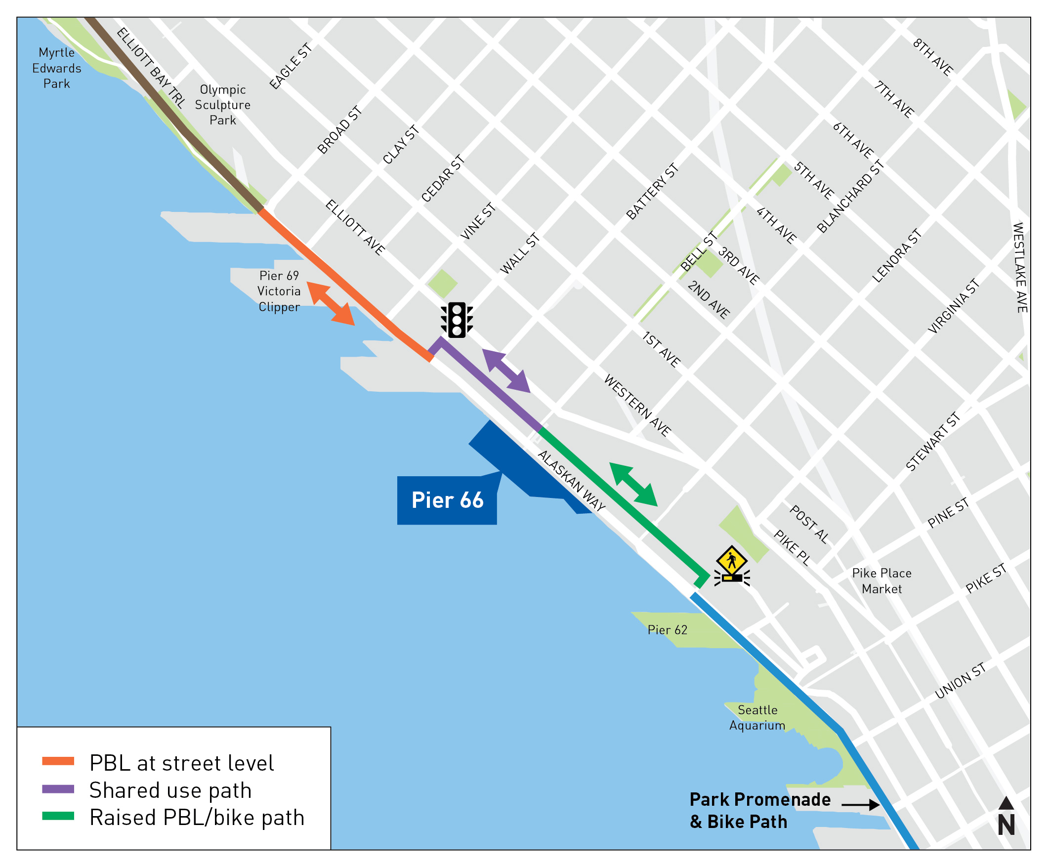
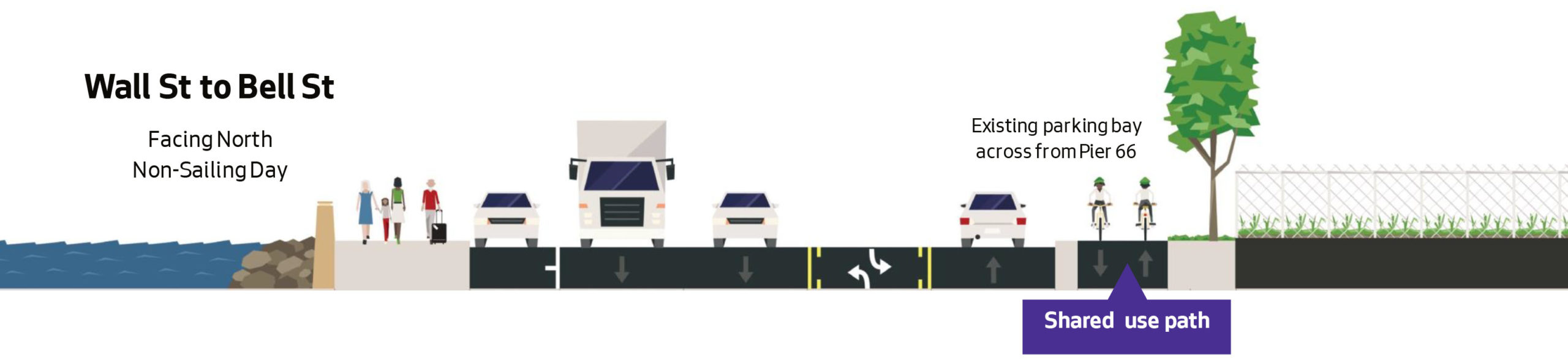
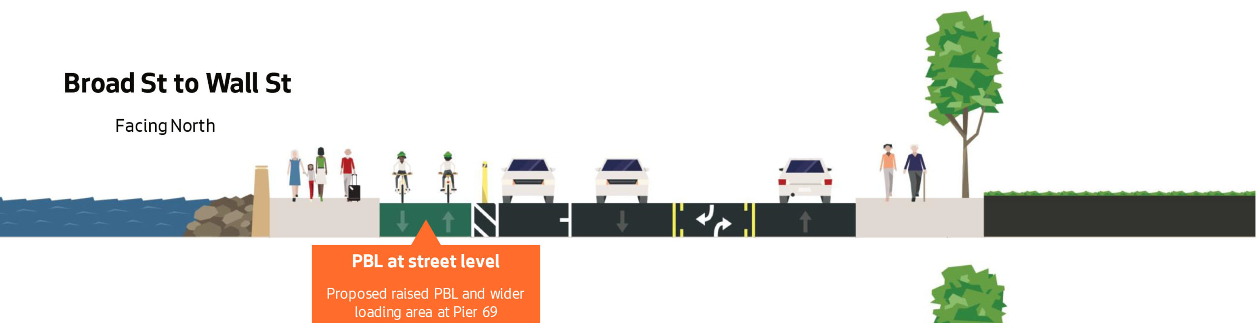
This is the most important bike route under construction in Seattle, and we must do it right. But the high-budget Waterfront Seattle project ends north of Pike Place Market, leaving a nine-block gap between the flashy new bikeway and the existing Elliott Bay Trail in Myrtle Edwards Park.
The northern end of the Waterfront Seattle project shows how the bikeway (blue lines) will continue along the west (waterfront) side of Alaskan Way until Virginia Street.
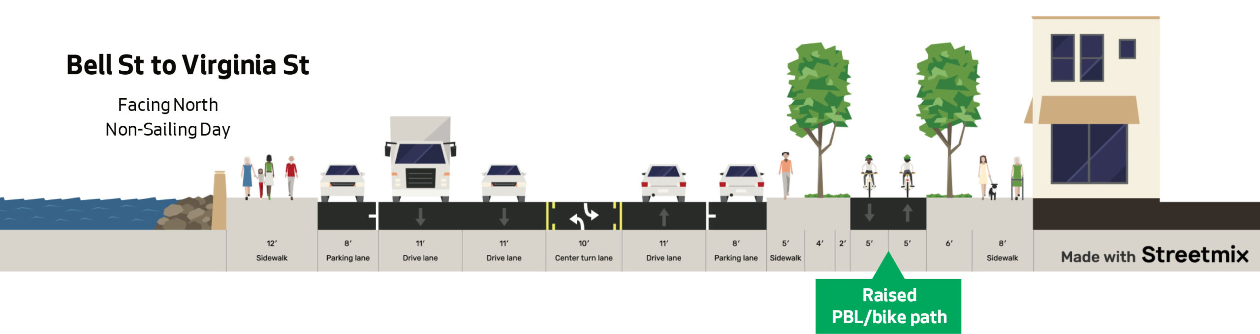
SDOT is currently designing a redesign of Alaskan Way through Belltown that will include a bike connection, but the current design concept bafflingly switches sides of the street twice within a span of six blocks. They are hosting an online open house about the project 4:30 p.m. Tuesday on MS Teams, which is a great opportunity to comment. Seattle Neighborhood Greenways also has a handy online form you can use to send a letter to elected officials.
The section of the Interurban North Trail near Lynnwood Transit Center is now open again following ten months of construction closure. This significantly shortens the ride through the area while also removing some awkward detour routing along the sidewalk.
Sound Transit completed its light rail and parking garage construction work on schedule to get the trail open for Bike Month. A section of the short Scriber Creek Trail will remain until the fall.
The reopened trail is actually a temporary asphalt path. Some sections will have wide paths for each direction while one shorter section will be a 10-foot, two-way path.
More details from Sound Transit:
After being closed for nearly ten months, the portion of the Interurban Trail between 52nd Ave. W and 44th Ave. W near the Lynnwood Transit Center will reopen on Sunday, May 1. The section of the trail was closed to allow construction crews to work on the future Lynnwood City Center light rail station, as well as the new parking garage.
Users will now have access to a temporary trail connection through this area while construction continues. The temporary trail connection will be paved with asphalt and include a two-way separated section with ten-foot wide lanes, as well as approximately 300 feet of 10-foot wide non-separated trail.
The Scriber Creek Trail connecting Scriber Creek Park to the Interurban Trail remains closed as construction at the future light rail station site continues. This trail connection is anticipated to open in fall 2022. Users should continue to use the detour route to connect to the Interurban Trail at 52nd Ave W and 44th Ave W. People should follow all detour signage and stay within marked trail detours.
The station at the Lynnwood Transit Center will serve one of the busiest transit centers in the region. A new garage will contain approximately 1,665 parking stalls in a five-story structure. Along with adjacent surface lots containing 226 stalls, the Lynnwood City Center Station will have nearly 1,900 parking stalls, approximately 500 more stalls than are on the current transit center site.
Sound Transit is simultaneously working to extend light rail north, south, east and west. After Lynnwood opens, passengers from the Lynnwood Transit Center will enjoy 20-minute rides to the University of Washington, 27-minute rides to downtown Seattle and 60-minute rides to Sea-Tac Airport. Trains from Lynnwood will also serve the Eastside and reach downtown Bellevue in 51 minutes.
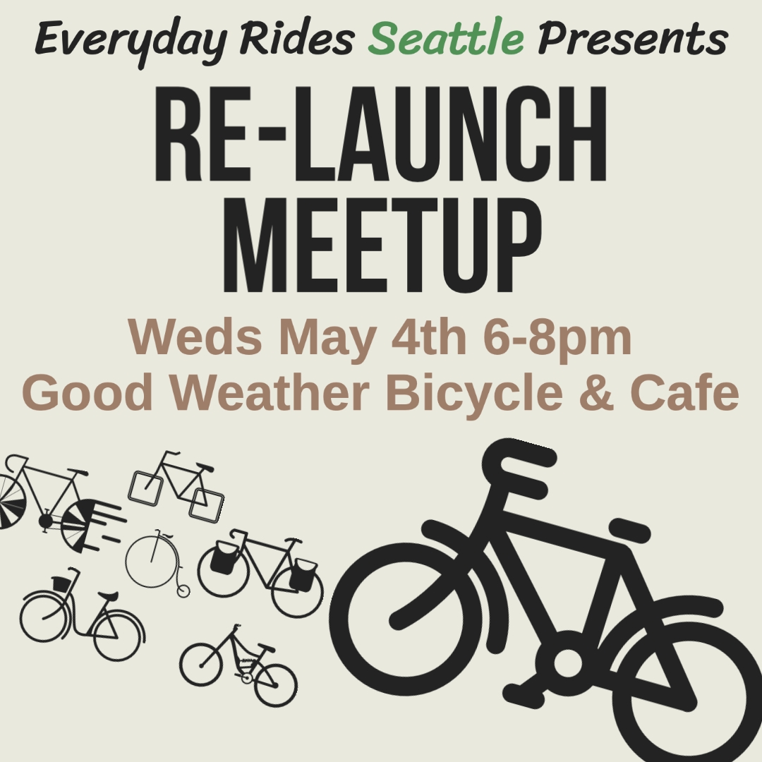
Bike events are roaring back to life in Seattle at a level not seen since 2019. Cascade Bicycle Club’s Bike Month calendar is packed, as is the Seattle Bike Blog Events Calendar. But that’s not all. After a two-year hiatus, Everyday Rides is relaunching its local bike fun calendar, and is hosting a relaunch meetup 6 p.m. tonight (5/4) at Good Weather Bicycle & Cafe on Capitol Hill.
“The pandemic threw everything for a loop, but the social cycling scene in Seattle is 🔥 right now and I’m super stoked for Summer,” wrote Everyday Rides creator Zach Hale in an email announcing the relaunch effort. “Come support Good Weather, have a drink, and chat about ideas for rides and events y’all would like to do this year. I’ll bring my bag of maps for folks to use and be available to help with ride planning and ideas for anyone looking for help making their ride dreams come true. Let’s fill the calendar this summer!”
Everyday Rides is not just a calendar, it’s also a tool to collect RSVPs and organize a ride group. A newly-added groups feature allows people to create and join private groups, which can post public events as well as events only visible to other members of the group. It can also host group conversations, so it can be a way to organize events and stay in touch. With more and more people ditching Facebook, Everyday Rides could be a more widely accessible home for your bike event listings.
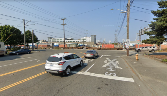
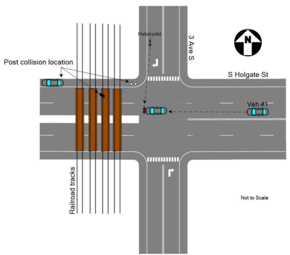
S Holgate Street at 3rd Ave S has a single stop sign facing 3rd Ave but no traffic control for users on Holgate. (Google maps)
Four days into 2022, someone riding a bike in SoDo, at the intersection of S Holgate Street and 3rd Ave S, was struck by someone driving a Hyundai Accent. Receiving substantial injuries in the crash, including a badly injured leg. The cyclist, Antonio Tiongco, was recorded as having his address registered at a social service agency in Belltown, and was presumed by the King County Medical Examiner’s office to be homeless.
Tiongco’s death was not noted by any major news outlets in Seattle, being one of at least twenty-one people presumed homeless who died in King County in just that month alone. So far in 2022, that number has reached 64, according to the medical examiner’s online dashboard. 188 people presumed homeless died in 2021, an increase from 167 in 2019. “Accident” is the leading cause of death, making up 62% of 2021 deaths and 72% of 2022 deaths.
The recently obtained police report details how the crash occurred, on a rainy January evening just before 5pm, nearly a half hour after sunset. The driver of the Hyundai was in the left lane of westbound Holgate heading toward the railroad tracks that cross Holgate just west of 3rd. Tiongco was attempting to cross Holgate at the same time. Traffic on 3rd has a stop sign, but there is no stop sign on Holgate at the intersection. Since October 1, 2020 people riding bikes can treat stop signs as yield signs in Washington State; there is no way to know whether Tiongco didn’t see the approaching vehicle coming or misjudged the distance on a rainy night. “Based upon my review of patrols investigation and interview of [the] driver…the proximate cause of this collision was Tiongco’s failure to obey the traffic control device (stop sign) and the grant the right of way to the 2014 Hyundai Accent,” the final report on the collision investigation states. Tiongco survived for ten days, passing away from his injuries on January 14th, 2022.
This diagram from the traffic collision investigation details how police reconstructed the crash. (Source: Seattle Police Department)
SODO is one of the most dangerous neighborhoods in Seattle for people to walk or bike in. In 2017, Celso Diaz was killed at 1st Ave S and S Andover Street where he worked. Diaz had been formerly homeless but had secured a place of his own to live when he was struck and killed by someone going twice the speed limit, who fled the scene.
Almost exactly two years before the 2022 incident, on January 7, 2020, Douglas Mayhew was walking across Holgate at 8th Ave S, where there is no marked crosswalk, when he was struck by the driver of a vehicle. He later died of his injuries. On October 2nd of that year, another pedestrian was struck and killed at 1st and Holgate. SoDo’s wide streets and unforgiving intersections are not designed with the safety of people outside vehicles in mind.
Our condolences go out to the family members and friends of Antonio Tiongco.
Bike Everywhere Day 2022 is May 20, but there are also bikey events throughout May to help encourage more people to bike or to simply celebrate how great it is to bike around this beautiful place. This is the first full-on Bike Month since 2019, as the pandemic cancelled most Bike Month events in 2020 and 2021. So get out there, meet people and show your support for local bike events.
Every day during busy travel times, people turning left from southbound 9th Avenue N block the bike lane and crosswalk across Mercer Street. This happens every signal cycle, forcing people to try to find a path through the mess of cars and trucks just to get across the street. It has been this way for years.
After witnessing this blockage every day on the way home from my kid’s preschool, I became convince that there is a $0 fix to the problem. Well, “fix” is maybe the wrong word. But for $0, the city could make the bike lane and crosswalk much more usable. It is such an obvious solution that I’m sure I am not the first person to think of it (though I did suggest it a half decade ago when it opened). I made the video above to explain the concept.
Mercer Street’s traffic signals have a so-called “Intelligent Transportation Systems Program,” which is supposed to dynamically adjust the signal timings based on the needs of street users. But it is not very “intelligent” if it allows this complete failure to occur every single day for years on end. The problem is that the ITS Program is designed to prioritize vehicle movement, not to make it easier to walk or bike. This is the same system that steals crosswalk time and gives it to cars.
It’s time for some old-fashioned human intervention.