This spike in gas prices will probably cost car-dependent folks more than any transit-funding or bike lane-building measure we’ve ever approved. But we won’t be left with anything to show for it. A bike network or expanded transit is an investment in community. Gas only burns.
Our reliance on gas is an enormous vulnerability in our society. We have almost no resilience against price increases. People barely scraping by are going to hurt the most. Many low-income folks live in places far away from jobs with no or poor transit service.
Biking can be a source of relief for many people, and I suspect we will see an increase in bicycling like we did during previous gas price spikes. If you can be a resource to help folks in your community get biking, do it. But moments like these make our region’s inequitable bike infrastructure so much more stark. Many communities hit hardest by gas prices are lacking safe and direct bike lanes and paths. Even communities that do have some paths are often too far from jobs to make biking widely feasible. Suburban sprawl severely inhibits biking and walking as transportation modes. A 15-mile (per direction) ride is possible for some, but not the masses.
Biking is best at getting around within a community, and transit is best at connecting communities to each other. So biking to transit is a viable option for many places. But those places need both quality transit and quality local bike facilities for this to truly work. Our region has made many improvements to biking and transit in recent years, so that’s the good news. A lot of people looking for alternatives will find them, which is great. But others will be left behind.
Investing in biking and transit is not an attack on people who drive. A bike or bus lane does not take away from car drivers. They are investments in resiliency and community strength.
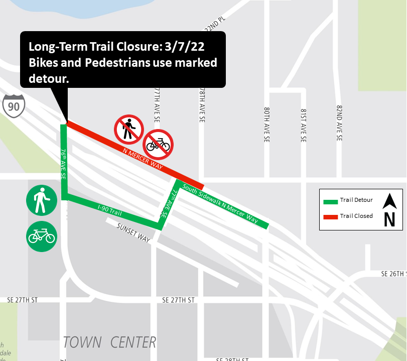
Work to build Mercer Island Station and redesign the bus connections there will displace a section of the I-90 Trail starting March 7, Sound Transit announced. Though the work area may change as work progresses, expect some kind of trail detour for about a year.
The closed section runs along the north side of N Mercer Way between 76th Ave SE and 80th Ave SE. This section is the most direct bike route option for people crossing the island. Crews will also close one of the lanes on N Mercer Way, taking it down to one lane in each direction.
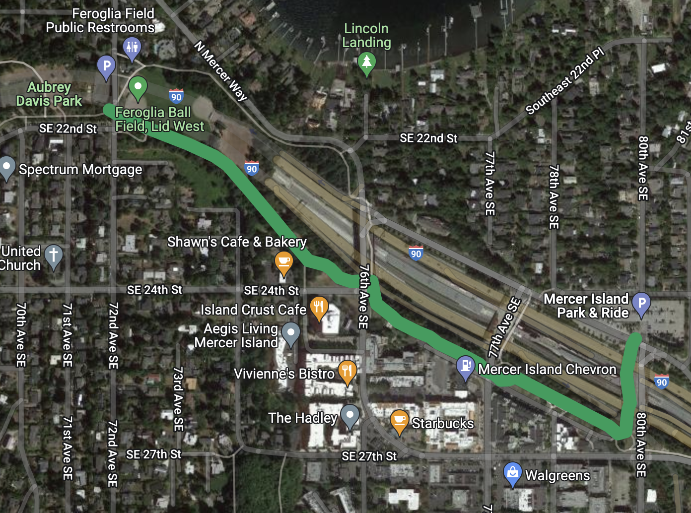
The good news is that there is already a trail connection that bypasses the closed section. In fact, maps often label this alternative trail “I-90 Trail” even though the Mercer Way route is used much more. It is a bit longer, but it is more pleasant. People who don’t want to detour can ride in mixed traffic on N Mercer Way, though there will not be a temporary bike path on the roadway.
The detour route sends riders south across the freeway in the trail along the east side of 76th Ave SE. That trail curves and heads east through a small freeway-adjacent park before reaching 77th Ave SE. The official route turns north on 77th to cross back over the freeway before sending riders east for a block on the sidewalk along the south side of Mercer Way. This sidewalk is not very wide, especially for two-way walking and biking travel.
Another option would be to start the detour all way back near the ball fields in Aubrey Davis Park by taking the south fork in the path rather than the more common north fork. This path stays south of I-90 and crosses 76th to connect to the detour route’s path. Then continue on the trail until reaching the existing trail connection on 80th, which connects back to Mercer Way and the rest of the I-90 Trail near the park and ride. Below is a map of the general idea:
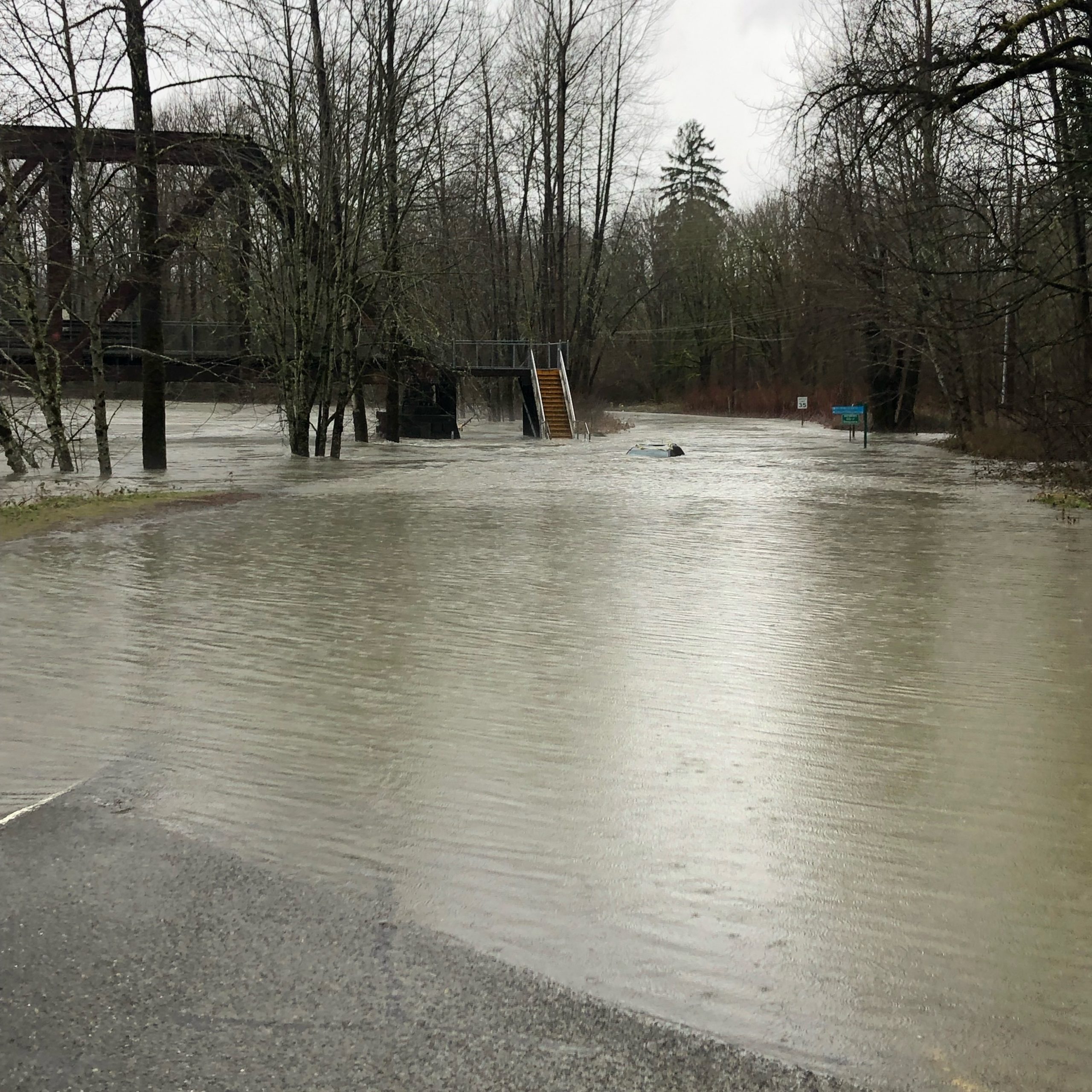
An enormous amount of water has fallen on our region, leading to flooding and landslides. So if you are planning a bike ride on a route near a river, be sure to check in with the King County Roads and Parks alert websites.
The worst flooding as of press time is along the Snoqualmie River. It is best to stay away, as there are road and trail closures at various points between Duvall and North Bend. This is not the day to ride the Snoqualmie Valley Trail if you can avoid it.
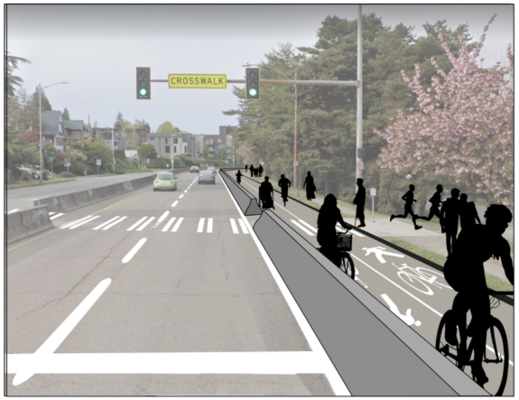
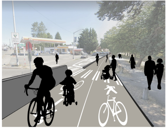
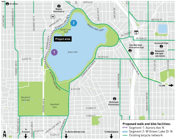
This week at an online open house, SDOT released the results of a survey the department conducted last year around the concept of creating a path for people walking and rolling along the Outer Loop along Green Lake Park’s western edge. Adjacent to Aurora Ave, no sidewalk currently exists, just a dirt path that frequently turns to mud. The idea of repurposing the curbside lane of Aurora, which is actually a continuation of a bus lane on a stretch of road that buses don’t currently use, as a space for people to walk and bike has been kicking around SDOT since mid-2020, according to records Seattle Bike Blog obtained last year. After hearing from over 5,000 people, a huge response for a survey like this, 40% of people said they supported the idea of converting the lane of Aurora compared to 29% of people who said they opposed it.
The curbside lane of Aurora Ave N is planned to be converted to walking and biking space by the end of the year. (SDOT)
SDOT also announced that they’ve selected an alternative to the final connection between this new Aurora path and the existing protected bike lane at the north end of the lake, via West Green Lake Drive N. The final design will be a two-way protected biking and walking lane along the lake side, with the rest of the street shifting to a new one-way traffic pattern in the southbound direction in order to retain parking along the street for residents. SDOT says they discarded making the street northbound due to concern about additional traffic diversion for drivers trying to head southbound. This option actually narrowly lost to the option that included parking removal, 42% to 47% but was the one selected by the city.
West Green Lake Dr N is proposed to be converted to one-way operation for cars, with a new two-way walking and biking path along the lake side up to Densmore Ave N. (SDOT)
And finally, the department announced that the project, which didn’t previously have construction funding identified, is now fully funded via the city’s Vision Zero program. Most of the $1 million cost is anticipated to come from purchasing concrete barriers for the segment along Aurora, but SDOT says they are looking at how to repurpose existing barriers from elsewhere to keep costs down. The Vision Zero program is expected to see a higher amount of revenue in the next few years thanks to an increase in the city’s commercial parking tax set to take effect this year. Previously Vision Zero funding has been used to create separated space for people to bike on 12th Ave S in Little Saigon and on NE 65th Street.
Once complete, the Green Lake Outer Loop project would finalize a safe place to bike around the entirety of Green Lake Park. (SDOT)
The survey, like nearly all surveys on transportation projects, wasn’t exactly representative of Seattle as a whole: only 22% of respondents said they are renters (renters are a majority of Seattle residents) and 80% of respondents said they are white. Green Lake Park receives some of the highest usage in the entire Seattle Parks system and how to use the street space immediately adjacent to it is a citywide concern, although attention to impacts to nearby residents should certainly be paid.
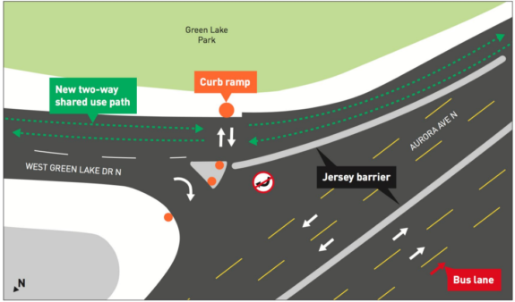
During the open house, SDOT shared early renderings of how the facility will work at the transition points between the different segments, including the infamous slip lane from Aurora onto West Green Lake Dr N, where drivers will no longer be allowed to exit because of the conversion to one-way traffic.
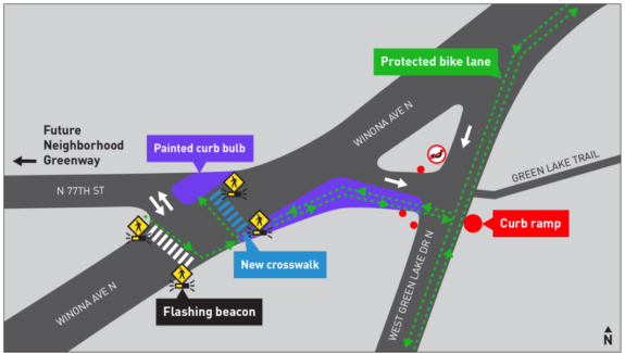
The existing slip lane from Aurora onto West Green Lake Dr N will be eliminated, with turns off Aurora restricted. (SDOT)SDOT will create a way for people on bikes to transition from the West Green Lake Dr N walking and biking space across Winona Ave N. (SDOT)
During the meeting, SDOT staff outlined a “worst-case scenario” of traffic impacts from the conversion of West Green Lake Dr N to one way operation: an additional 500 vehicles using Winona Ave N instead and an average delay per vehicle of 18 seconds for drivers turning off Aurora. In return, the city will be creating a pathway for people biking around the entirety of Green Lake Park. Currently Seattle Parks is prohibiting people on bikes from using the inner loop trail, with a permanent restriction on the table as that department assesses the competing uses for that trail.
Creating joint walking and biking space isn’t a widespread habit of the department, but in this case allowing people who walk or roll to use the bike space is probably the only way the city was going to be able to cheaply create an ADA-compliant pathway around the west edge of Green Lake Park. Because SDOT is treating the new facility as a multi-use trail, they will not be installing traffic signals for bike traffic at the signalized crosswalks across Aurora as they might with a protected bike lane project.
SDOT is currently aiming for a construction date of “Summer-Fall” 2022 for all of these improvements, making it one of the fastest rollouts of quick build protected biking and walking infrastructure in recent memory. Across town, the department has still not even announced a planned route for a safe biking corridor in north Beacon Hill after spending all of 2021 doing outreach around the different options. This disparity can’t be ignored when looking at the Green Lake Outer Loop project and the vast differences in the ability of different areas of the city to be able to move projects like this forward.
You can read more about the Green Lake Outer Loop at the project website.
The two-decade bicycle helmet law experiment is drawing to a close as Seattle, the largest remaining city in the United States with such a law, no longer requires them. The King County Board of Health voted Thursday to repeal its all-ages helmet law after months of debate, a decision that also covers Seattle. The law change went into effect immediately.
The Board made it very clear in their deliberations and in a companion resolution that they still strongly recommend the use of bicycle helmets. But they no longer consider police enforcement the best way to promote their use because of the dangers associated with biased policing.
There were times when it seemed so politically impossible to repeal King County’s rare all-ages bicycle helmet law that it didn’t seem worth trying. But times have changed both within local politics and within global bicycling culture, both of which have pretty big implications for the future of safe streets and beyond.
Bicycle helmet laws were a well-intentioned detour
Let’s rewind to 1993. I-90 finally opened in Seattle, and the region’s decades-long binge of new and wider freeways had led to a seemingly never-ending expansion of sprawling suburbs far away from the city center. People biked a lot in Seattle, at least compared to most other cities in the United States, thanks in large part to the wild success of the Burke-Gilman Trail, the poster child of the Rails-to-Trails movement. But beyond trails, there was practically no momentum to significantly redesign city streets to make them safer for cycling. There was also almost no funding for such an effort. Yet people were getting seriously injured or killed while biking, and people wanted to take action to prevent these tragedies. This was how the bicycle helmet law took hold.
In 1986, an estimated 1% of children wore bicycle helmets in King County, according to the Children’s Bicycle Helmet Coalition (“CBHC”) in a March 1993 Seattle Times story (Seattle Public Library account required to access). But bicycle helmets became more widely available and public information efforts from Cascade Bicycle Club, the Washington Bicycle Federation and the CBHC changed that. By 1993, when King County enacted its helmet law, bicycle helmet use was up to 40% for children and over 50% for adults, according to Cascade. The King County law was supposed to precede a statewide law, but the statewide bill failed to pass.
The early 1990s was also when major bicycle racing organizations started to require helmets for athletes, so the next logical question was whether people riding on city streets should be required to wear them, too. Since the head is the most vulnerable part of the body, it seemed like a good way to prevent death and serious brain injury. This is why Cascade and WA Bike Fed were proponents of the law at the time, and why the law was passed by the Board of Health rather than by the Seattle or King County councils at large. It was a public health effort. (The law initially did not affect Seattle, which had its own Public Health Department. The law expanded to include Seattle when the two public health boards merged in 2003.)
But why single out people on bikes? Yes, head injuries were the leading cause of death for people biking, but the same could be said for people fatally injured inside of cars or walking across the street. Yet there was seemingly no effort at all to mandate that people wear helmets while inside motor vehicles or using crosswalks. While people can easily understand the difference between driving a race car and driving to the grocery store, all bicycling was essentially treated as a sporting activity. If it’s a sport, then wearing a bicycle helmet seemed as logical as wearing a football helmet. (more…)
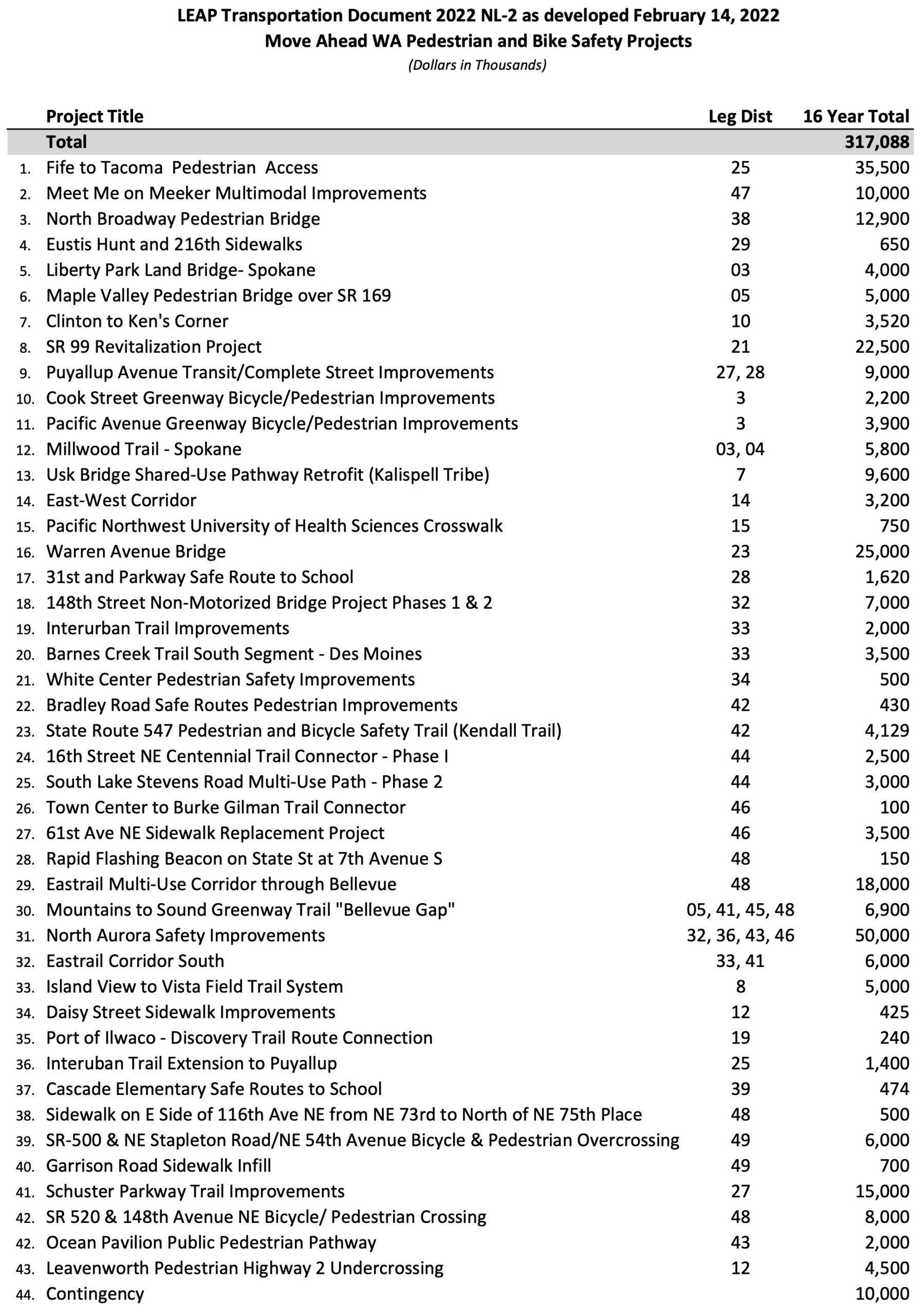
As soon as Washington State legislators released their Move Ahead Washington transportation funding proposal earlier this month, it drew a wave of enthusiastic support from transportation organizations across the state. Lee Lambert, Executive Director of Washington Bikes, called the investments in walking and biking “unprecedented.” And he’s right.
The 16-year, $16 billion “Move Ahead Washington” package passed in the Senate this week with about $1.3 billion for walking and biking safety included. As a percentage of the total, that is far better than what the legislators were discussing during the 2021 session from a safe streets and transit perspective. It is also about four-times better than the “Connecting Washington” funding package legislators passed in 2015 with a Republican-controlled Senate and Democratic-controlled House. Connecting Washington only carved out about 6% of its funding for walking, biking and transit. As pitiful as that was, it was about double the amount in the previous transportation package. Now with both chambers under the control of Democrats, this package is a test of whether the party is willing to invest significantly more seriously in safe streets and transit. The Senate passed the bill along party lines without support from Republicans.
Move Ahead Washington would massively increase statewide Safe Routes to School funding, which is also a big investment in neighborhood safety. The bill would also fund a major expansion of school-based bicycle education and a fund a free bike program for students. It also includes a state-led complete streets effort, which is a huge deal. State routes are very often the most dangerous streets in any city or community that has one. Cities still have a lot of work to do to make their own streets safer, but they can only do so much for their communities without state action.
The package also funds a list of specific walking and biking projects including major trail improvements, such as the I-90 Trail in Bellevue and the EasTrail. You can check out the bill text and supporting documents as passed by the Senate on the Senate’s budget bills website. Here’s the walking and biking project list: